
New update! (4.3.6) - offroad waypoints
-

Hi all!

It is time for a new update!

This version is all about the support of offroad waypoints!Offroad waypoints
Within the online MRA Routeplanner you can very conveniently mark some waypoints as "offroad". The main idea behind this is to skip a section of road that is unknown to the selected routing engine (HERE / TomTom / OSM). Ideal to avoid roads marked as closed (either seasonal or long term damaged) or things such as ferries.
The app had no idea how to work with these "offroad" waypoints and just treated them as normal ones. Causing the route to be different than planned

As of now, the app does support the offroad waypoints!

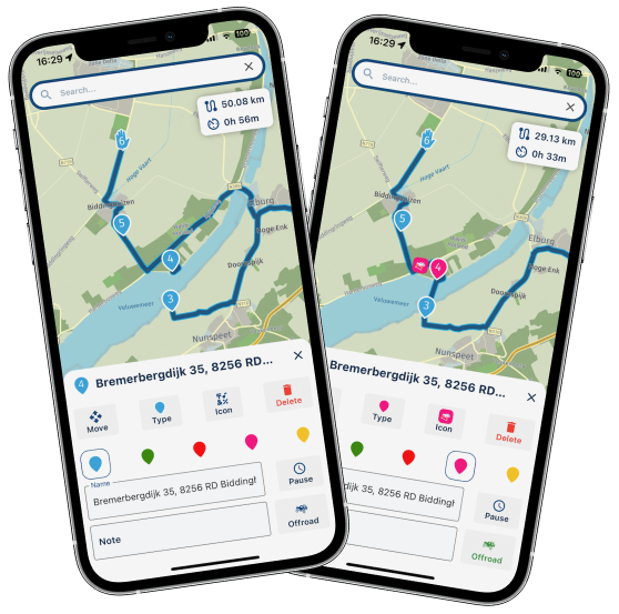
In the planner you can edit any route you like and mark any waypoint as offroad! Just as in the website.
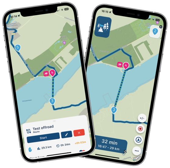
If you then choose to navigate a route with offroad waypoints, you will see straight lines on the offroad sections. Just as planned!

These sections will be made extra clear with a nice dashed line.
While navigating over an offroad section, some things are however different:
- No visual instructions
- No audio instructions
- Possible loss of ETA information
- Automatic recalculations disabled
You don't need them anyway, as you're offroad.
Android Auto / CarPlay do not support the disabling of some visual elements. This can result in a slightly suboptimal experience when on an offroad section.As offroad waypoints rely on track navigation under the hood, you do need to be online for an optimal experience. When offline, you will receive an appropriate warning

By introducing this feature in the app, we now support all the crucial features that the website has
Compass changes
A lot of users were unaware what the selected camera mode was. Not entirely their fault as the icon remained the same and you did not receive any other confirmation.
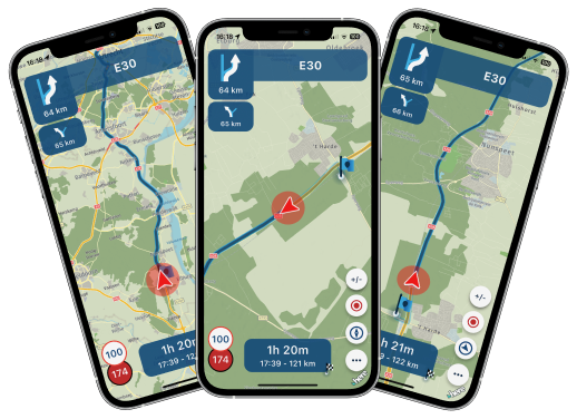
Now when tapping the compass, the icon will change based on the selected mode. Also, you will receive a short textual confirmation of the selected camera mode.
Bluetooth controller changes
- Support for Remotek firmware version 2.x
- Fixed issue with BMW Carpe Iter controller
Minor fixes
- iPad export option
- Manual day / night changes from CarPlay / Android Auto changed the base map style incorrectly
- Missing pause icons
- Not showing the same warning multiple times
Minor changes
- Added a loader in the in-app planner
- Not including current location when calculating routes that are far away
- Showing original route just before starting navigation (not only while navigating)
- Open route from RouteXpert library or activity feed by tapping the image
- Flow for starting routes created in a map other than HERE
Android specific changes
- Hide the notification bar and on screen navigation buttons when navigating
- Support for more "intents" ensuring MyRoute-app is displayed more often as supported app to navigate with (such as with DMD2)
What's next
That's it for now!
We are currently working on a complete rework of the home screen of the app Expecting a release of this somewhere in March.The idea behind this is to improve the visual appearance of the app, less clicks for the user, smoother transition to navigation and offline availability of the home screen maps too.
Cheers,
Corjan -
Hi all!
It is time for a new update!
This version is all about the support of offroad waypoints!Offroad waypoints
Within the online MRA Routeplanner you can very conveniently mark some waypoints as "offroad". The main idea behind this is to skip a section of road that is unknown to the selected routing engine (HERE / TomTom / OSM). Ideal to avoid roads marked as closed (either seasonal or long term damaged) or things such as ferries.
The app had no idea how to work with these "offroad" waypoints and just treated them as normal ones. Causing the route to be different than planned
As of now, the app does support the offroad waypoints!
In the planner you can edit any route you like and mark any waypoint as offroad! Just as in the website.
If you then choose to navigate a route with offroad waypoints, you will see straight lines on the offroad sections. Just as planned!
These sections will be made extra clear with a nice dashed line.
While navigating over an offroad section, some things are however different:
- No visual instructions
- No audio instructions
- Possible loss of ETA information
- Automatic recalculations disabled
You don't need them anyway, as you're offroad.
Android Auto / CarPlay do not support the disabling of some visual elements. This can result in a slightly suboptimal experience when on an offroad section.As offroad waypoints rely on track navigation under the hood, you do need to be online for an optimal experience. When offline, you will receive an appropriate warning
By introducing this feature in the app, we now support all the crucial features that the website has
Compass changes
A lot of users were unaware what the selected camera mode was. Not entirely their fault as the icon remained the same and you did not receive any other confirmation.
Now when tapping the compass, the icon will change based on the selected mode. Also, you will receive a short textual confirmation of the selected camera mode.
Bluetooth controller changes
- Support for Remotek firmware version 2.x
- Fixed issue with BMW Carpe Iter controller
Minor fixes
- iPad export option
- Manual day / night changes from CarPlay / Android Auto changed the base map style incorrectly
- Missing pause icons
- Not showing the same warning multiple times
Minor changes
- Added a loader in the in-app planner
- Not including current location when calculating routes that are far away
- Showing original route just before starting navigation (not only while navigating)
- Open route from RouteXpert library or activity feed by tapping the image
- Flow for starting routes created in a map other than HERE
Android specific changes
- Hide the notification bar and on screen navigation buttons when navigating
- Support for more "intents" ensuring MyRoute-app is displayed more often as supported app to navigate with (such as with DMD2)
What's next
That's it for now!
We are currently working on a complete rework of the home screen of the app Expecting a release of this somewhere in March.The idea behind this is to improve the visual appearance of the app, less clicks for the user, smoother transition to navigation and offline availability of the home screen maps too.
Cheers,
Corjan
@Corjan-Meijerink Nice, thanks for the info.
How do I mark a waypoint as offroad on the web planner? I can't find it anywhereGSA1250
HD Street Glide
XT500 x 2 -
@Corjan-Meijerink Nice, thanks for the info.
How do I mark a waypoint as offroad on the web planner? I can't find it anywhere
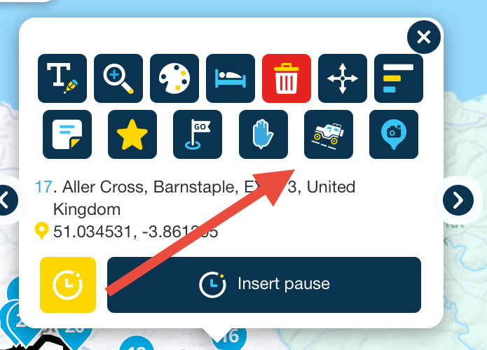
@Rob-Kelley The skip button in the route point menu, it has a 4x4 icon.
Always willing to help if I can.
Triumph Tiger 1200 XRT called Tina.
MRA Navigation Next and SilverFox BJ8 -
@Rob-Kelley The skip button in the route point menu, it has a 4x4 icon.
@Nick-Carthew ah that one, I am just playing it that now, I was looking for a button saying 'off road'
From what I can see, it doesn't route or count the mileage between this and the previous point. -
@Nick-Carthew ah that one, I am just playing it that now, I was looking for a button saying 'off road'
From what I can see, it doesn't route or count the mileage between this and the previous point.
@Rob-Kelley What's that four point arrow button to the right of the Bin? I don't have that and not seen it before.
-
@Nick-Carthew ah that one, I am just playing it that now, I was looking for a button saying 'off road'
From what I can see, it doesn't route or count the mileage between this and the previous point.
@Rob-Kelley Correct, time and distance calculations between the two route points are turned off when skip is used.
-
@Rob-Kelley What's that four point arrow button to the right of the Bin? I don't have that and not seen it before.
@Rob-Kelley said in New update! (4.3.6) - offroad waypoints:
@Rob-Kelley What's that four point arrow button to the right of the Bin? I don't have that and not seen it before.
That’s turns on a set of crosshairs for moving a route point on a touch screen (phone in my case).
I touch the cross, crosshairs appear and I move the map around until the position I want is under the crosshairs and then I tap the move button.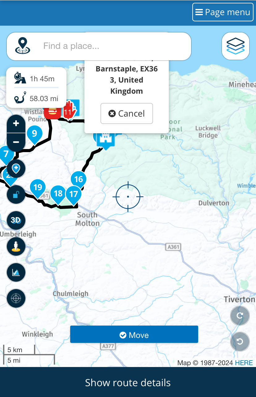
-
Hi all!
It is time for a new update!
This version is all about the support of offroad waypoints!Offroad waypoints
Within the online MRA Routeplanner you can very conveniently mark some waypoints as "offroad". The main idea behind this is to skip a section of road that is unknown to the selected routing engine (HERE / TomTom / OSM). Ideal to avoid roads marked as closed (either seasonal or long term damaged) or things such as ferries.
The app had no idea how to work with these "offroad" waypoints and just treated them as normal ones. Causing the route to be different than planned
As of now, the app does support the offroad waypoints!
In the planner you can edit any route you like and mark any waypoint as offroad! Just as in the website.
If you then choose to navigate a route with offroad waypoints, you will see straight lines on the offroad sections. Just as planned!
These sections will be made extra clear with a nice dashed line.
While navigating over an offroad section, some things are however different:
- No visual instructions
- No audio instructions
- Possible loss of ETA information
- Automatic recalculations disabled
You don't need them anyway, as you're offroad.
Android Auto / CarPlay do not support the disabling of some visual elements. This can result in a slightly suboptimal experience when on an offroad section.As offroad waypoints rely on track navigation under the hood, you do need to be online for an optimal experience. When offline, you will receive an appropriate warning
By introducing this feature in the app, we now support all the crucial features that the website has
Compass changes
A lot of users were unaware what the selected camera mode was. Not entirely their fault as the icon remained the same and you did not receive any other confirmation.
Now when tapping the compass, the icon will change based on the selected mode. Also, you will receive a short textual confirmation of the selected camera mode.
Bluetooth controller changes
- Support for Remotek firmware version 2.x
- Fixed issue with BMW Carpe Iter controller
Minor fixes
- iPad export option
- Manual day / night changes from CarPlay / Android Auto changed the base map style incorrectly
- Missing pause icons
- Not showing the same warning multiple times
Minor changes
- Added a loader in the in-app planner
- Not including current location when calculating routes that are far away
- Showing original route just before starting navigation (not only while navigating)
- Open route from RouteXpert library or activity feed by tapping the image
- Flow for starting routes created in a map other than HERE
Android specific changes
- Hide the notification bar and on screen navigation buttons when navigating
- Support for more "intents" ensuring MyRoute-app is displayed more often as supported app to navigate with (such as with DMD2)
What's next
That's it for now!
We are currently working on a complete rework of the home screen of the app Expecting a release of this somewhere in March.The idea behind this is to improve the visual appearance of the app, less clicks for the user, smoother transition to navigation and offline availability of the home screen maps too.
Cheers,
Corjan
@Corjan-Meijerink said in New update! (4.3.6) - offroad waypoints:
Now when tapping the compass, the icon will change based on the selected mode. Also, you will receive a short textual confirmation of the selected camera mode.
Thank you, nice to see a suggestion making it's way into the app so quickly.
GSA1250
HD Street Glide
XT500 x 2 -
@Corjan-Meijerink said in New update! (4.3.6) - offroad waypoints:
Now when tapping the compass, the icon will change based on the selected mode. Also, you will receive a short textual confirmation of the selected camera mode.
Thank you, nice to see a suggestion making it's way into the app so quickly.
@Rob-Kelley Good suggestions are always appreciated!
Especially when small and easy to implement I always try to process user feedback as fast as possible. -
Hi all!
It is time for a new update!
This version is all about the support of offroad waypoints!Offroad waypoints
Within the online MRA Routeplanner you can very conveniently mark some waypoints as "offroad". The main idea behind this is to skip a section of road that is unknown to the selected routing engine (HERE / TomTom / OSM). Ideal to avoid roads marked as closed (either seasonal or long term damaged) or things such as ferries.
The app had no idea how to work with these "offroad" waypoints and just treated them as normal ones. Causing the route to be different than planned
As of now, the app does support the offroad waypoints!
In the planner you can edit any route you like and mark any waypoint as offroad! Just as in the website.
If you then choose to navigate a route with offroad waypoints, you will see straight lines on the offroad sections. Just as planned!
These sections will be made extra clear with a nice dashed line.
While navigating over an offroad section, some things are however different:
- No visual instructions
- No audio instructions
- Possible loss of ETA information
- Automatic recalculations disabled
You don't need them anyway, as you're offroad.
Android Auto / CarPlay do not support the disabling of some visual elements. This can result in a slightly suboptimal experience when on an offroad section.As offroad waypoints rely on track navigation under the hood, you do need to be online for an optimal experience. When offline, you will receive an appropriate warning
By introducing this feature in the app, we now support all the crucial features that the website has
Compass changes
A lot of users were unaware what the selected camera mode was. Not entirely their fault as the icon remained the same and you did not receive any other confirmation.
Now when tapping the compass, the icon will change based on the selected mode. Also, you will receive a short textual confirmation of the selected camera mode.
Bluetooth controller changes
- Support for Remotek firmware version 2.x
- Fixed issue with BMW Carpe Iter controller
Minor fixes
- iPad export option
- Manual day / night changes from CarPlay / Android Auto changed the base map style incorrectly
- Missing pause icons
- Not showing the same warning multiple times
Minor changes
- Added a loader in the in-app planner
- Not including current location when calculating routes that are far away
- Showing original route just before starting navigation (not only while navigating)
- Open route from RouteXpert library or activity feed by tapping the image
- Flow for starting routes created in a map other than HERE
Android specific changes
- Hide the notification bar and on screen navigation buttons when navigating
- Support for more "intents" ensuring MyRoute-app is displayed more often as supported app to navigate with (such as with DMD2)
What's next
That's it for now!
We are currently working on a complete rework of the home screen of the app Expecting a release of this somewhere in March.The idea behind this is to improve the visual appearance of the app, less clicks for the user, smoother transition to navigation and offline availability of the home screen maps too.
Cheers,
Corjan
As offroad waypoints rely on track navigation under the hood, you do need to be online for an optimal experience. When offline, you will receive an appropriate warning
just curious: why do you need to be online to navigate a track? what's the "optimal" experience?
-
As offroad waypoints rely on track navigation under the hood, you do need to be online for an optimal experience. When offline, you will receive an appropriate warning
just curious: why do you need to be online to navigate a track? what's the "optimal" experience?
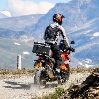
@cvlmtg Good point, many off-road routes in the mountains, for example, do not go together with mobile data... Offline use is the only option.
-
Super hoe jullie toch steeds weer bezig zijn met het verder verbeteren en uitbreiden van de Next App.
iets waar wij als Eindgebruikers heel blij mee zijn .Vraagje
In de grote update die jullie voor Maart gepland hebben is de snelheidsmeter in het scherm tijdens het rijden zonder te navigeren daar nu ook in meegenomen ?
dat is echt iets wat ik nog steeds mis
It's great how you are always working on further improving and expanding the Next App.
something that we as end users are very happy with.Question
In the major update you have planned for March, the speedometer on the screen while driving without navigating is now also included?
that's really something I still miss
-
As offroad waypoints rely on track navigation under the hood, you do need to be online for an optimal experience. When offline, you will receive an appropriate warning
just curious: why do you need to be online to navigate a track? what's the "optimal" experience?
@cvlmtg that's unfortunately a technical limitation from HERE's side
I have requested offline support for track navigation! Not sure if or how soon they will honour that request. -
Super hoe jullie toch steeds weer bezig zijn met het verder verbeteren en uitbreiden van de Next App.
iets waar wij als Eindgebruikers heel blij mee zijn .Vraagje
In de grote update die jullie voor Maart gepland hebben is de snelheidsmeter in het scherm tijdens het rijden zonder te navigeren daar nu ook in meegenomen ?
dat is echt iets wat ik nog steeds mis
It's great how you are always working on further improving and expanding the Next App.
something that we as end users are very happy with.Question
In the major update you have planned for March, the speedometer on the screen while driving without navigating is now also included?
that's really something I still miss
@Erik-35 Dank voor de mooie woorden!
Dat is nog in overweging. Anders gaat het zeker daarna wel komen. -
As offroad waypoints rely on track navigation under the hood, you do need to be online for an optimal experience. When offline, you will receive an appropriate warning
just curious: why do you need to be online to navigate a track? what's the "optimal" experience?

@cvlmtg said in New update! (4.3.6) - offroad waypoints:
just curious: why do you need to be online to navigate a track? what's the "optimal" experience?
@Corjan-Meijerink already explained. I'd just like to add that the availability of an internet connection is mostly important at the start of your route-as-track, especially if recalculation is disabled. The track that matches your route gets fetched from the online platform. If that is not possible, the app imitates a track based on your route, but that is less precise, and you can see the track cutting edges sometimes.
I assume that when once the track is fetched online, losing internet connection is no big deal. So most often, hopefully hotel wifi will be good enough at the start of the route. If I am completely mistaken, hopefully @Corjan-Meijerink will correct me
I am just an enthusiastic MRA user, and hope you will be one too!
Most motorcycle problems are caused by the nut that connects the handlebar to the saddle.
Check out RideSleepRepeat.eu, a biker community for sharing stays across Europe
-
@cvlmtg said in New update! (4.3.6) - offroad waypoints:
just curious: why do you need to be online to navigate a track? what's the "optimal" experience?
@Corjan-Meijerink already explained. I'd just like to add that the availability of an internet connection is mostly important at the start of your route-as-track, especially if recalculation is disabled. The track that matches your route gets fetched from the online platform. If that is not possible, the app imitates a track based on your route, but that is less precise, and you can see the track cutting edges sometimes.
I assume that when once the track is fetched online, losing internet connection is no big deal. So most often, hopefully hotel wifi will be good enough at the start of the route. If I am completely mistaken, hopefully @Corjan-Meijerink will correct me
@Con-Hennekens No not really
Starting online and then going offline won't work result in issues.However once you are offline there only needs to be the slightest deviation of the route to require internet for optimal experience. Even when recalculations are disabled and you rejoin the track, internally stuff is recalculated. Hence you'd ideally have internet.
-
@Con-Hennekens No not really
Starting online and then going offline won't work result in issues.However once you are offline there only needs to be the slightest deviation of the route to require internet for optimal experience. Even when recalculations are disabled and you rejoin the track, internally stuff is recalculated. Hence you'd ideally have internet.
Good to know!
I understand that the recalculation, which requires an internet connection, always affects the route, i.e. the ‘blue line’.
However, the track (or the initially calculated route when navigation route-as-track) is independent; the ‘white line’ remains visible in its original state, even without an internet connection, because it is stored locally on the device.Is this correct?
-
Good to know!
I understand that the recalculation, which requires an internet connection, always affects the route, i.e. the ‘blue line’.
However, the track (or the initially calculated route when navigation route-as-track) is independent; the ‘white line’ remains visible in its original state, even without an internet connection, because it is stored locally on the device.Is this correct?
-
@Martin-Wilcke That is correct!
@Corjan-Meijerink
Excellent!
No matter what, you can still follow the track on sight.
I can't wait to try the new ‘Offroad Waypoints’ feature in MRA NN. It will make planning and navigating even longer, non-routable sections so simple.
You have developed an incredible solution that provides track/route-as-track navigation combined with offroad capabilities, which I have never seen in any other navigation software.
Well done! -
@Corjan-Meijerink
Excellent!
No matter what, you can still follow the track on sight.
I can't wait to try the new ‘Offroad Waypoints’ feature in MRA NN. It will make planning and navigating even longer, non-routable sections so simple.
You have developed an incredible solution that provides track/route-as-track navigation combined with offroad capabilities, which I have never seen in any other navigation software.
Well done!
@Martin-Wilcke Thanks!
Hello! It looks like you're interested in this conversation, but you don't have an account yet.
Getting fed up of having to scroll through the same posts each visit? When you register for an account, you'll always come back to exactly where you were before, and choose to be notified of new replies (either via email, or push notification). You'll also be able to save bookmarks and upvote posts to show your appreciation to other community members.
With your input, this post could be even better 💗
Register Login
-
 0748
0748
-
 1514
1514
-
0524
-
06279
-
 06242
06242
-
04146
-
 17225
17225
-
0367