"Route as Track" wird nicht wie geplant navigiert
-
@Martin-Wilcke : Hey Martin,
versuche es mal mit der GuRu Maps - App, nach etwas einarbeiten kannst Du dem Track knallhart folgen bzw. die Route wählen … geht auch sehr gut mit der Remotek One zusammen zu bedienen. VG
VG Hubert
Beta Test "Next App" dazu die Hardware .
iPad 9. Gen iOS 26.5.2/ iPhone 16e iOS 26.5/ Navi iPhone Xr iOS 18.7.9 / PC mit MS Win11 /❗️MyRoute-App im Cradel und Remotek-One❗️ Info zu MRA & Remotek One -
@Martin-Wilcke : Hey Martin,
versuche es mal mit der GuRu Maps - App, nach etwas einarbeiten kannst Du dem Track knallhart folgen bzw. die Route wählen … geht auch sehr gut mit der Remotek One zusammen zu bedienen. VG@Hubert-Thoring
Danke für den Tipp!Es gibt einige gute Trackplanung-Apps, hauptsächlich aus dem Bereich hiking & biking, die auch Planungen für Motorrad/Auto ermöglichen. Hier ist Locus Maps mein Favorit; unter anderem auch deshalb, weil es einen recht guten WebPlaner bietet.
MRA ist für mich eine klassische Routenplanungs-App, also eher in Konkurrenz zu Kurviger & Co.
-
I did not read the full thread and did not test anything concerning this, but want to give these tips:
- When a route that has the OSM (or TT) map set as basemap is opened in NN, it will always be opened as track, so there is no route recalculation on basis of the HERE map (but of course a track calculation is done, but distances between trackpoints cannot lead to these kind of differences).
- could it be possible when you still have the compare to HERE function active, a save from the webplanner leads to a route based on HERE instead of the basemap? Maybe that's the difference. I never saw anything like this, but I seldomly use compare functions. This might explain perhaps.
I am just an enthusiastic MRA user, and hope you will be one too!
Most motorcycle problems are caused by the nut that connects the handlebar to the saddle.
Check out RideSleepRepeat.eu, a biker community for sharing stays across Europe
-
I did not read the full thread and did not test anything concerning this, but want to give these tips:
- When a route that has the OSM (or TT) map set as basemap is opened in NN, it will always be opened as track, so there is no route recalculation on basis of the HERE map (but of course a track calculation is done, but distances between trackpoints cannot lead to these kind of differences).
- could it be possible when you still have the compare to HERE function active, a save from the webplanner leads to a route based on HERE instead of the basemap? Maybe that's the difference. I never saw anything like this, but I seldomly use compare functions. This might explain perhaps.
Thanks for your hints!
It's not about comparing OSM and HERE or any other interaction between them; it's a pure OSM issue.
Here are three simple steps for a check:
-
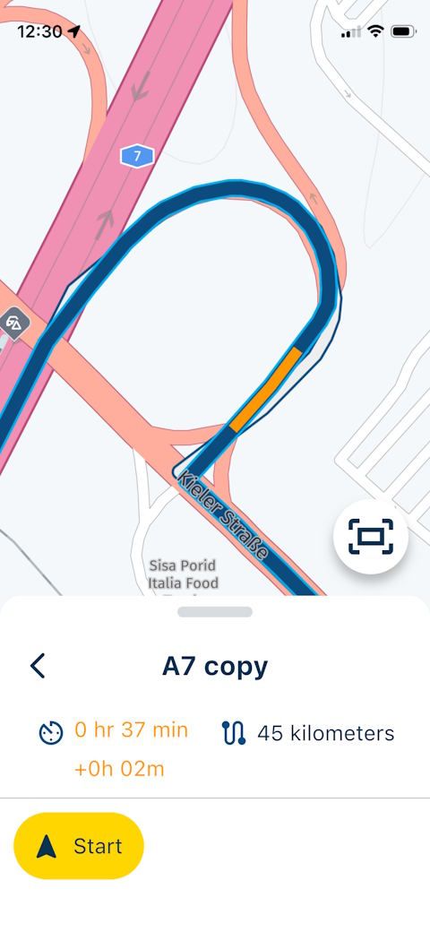
open and use this route; the goal is to avoid the A7 Motorway
https://www.myrouteapp.com/en/social/route/12968571?mode=share -
turn on Toolkit > Curves > Average. The route line changes accordingly; however, if you open this route for navigation, the A7 is used anyway
-
turn off Curves > Average and set Avoid > Highway instead. This works as expected when opening for navigation
-
Thanks for your hints!
It's not about comparing OSM and HERE or any other interaction between them; it's a pure OSM issue.
Here are three simple steps for a check:
-
open and use this route; the goal is to avoid the A7 Motorway
https://www.myrouteapp.com/en/social/route/12968571?mode=share -
turn on Toolkit > Curves > Average. The route line changes accordingly; however, if you open this route for navigation, the A7 is used anyway
-
turn off Curves > Average and set Avoid > Highway instead. This works as expected when opening for navigation
@Martin-Wilcke, Yes I see what you mean... Funny thing is that when you use TomTom instead of OSM for your curvy route, things work as expected
")
-
-
I did not read the full thread and did not test anything concerning this, but want to give these tips:
- When a route that has the OSM (or TT) map set as basemap is opened in NN, it will always be opened as track, so there is no route recalculation on basis of the HERE map (but of course a track calculation is done, but distances between trackpoints cannot lead to these kind of differences).
- could it be possible when you still have the compare to HERE function active, a save from the webplanner leads to a route based on HERE instead of the basemap? Maybe that's the difference. I never saw anything like this, but I seldomly use compare functions. This might explain perhaps.
@Con-Hennekens said in "Route as Track" wird nicht wie geplant navigiert:
When a route that has the OSM (or TT) map set as basemap is opened in NN, it will always be opened as track, so there is no route recalculation on basis of the HERE map
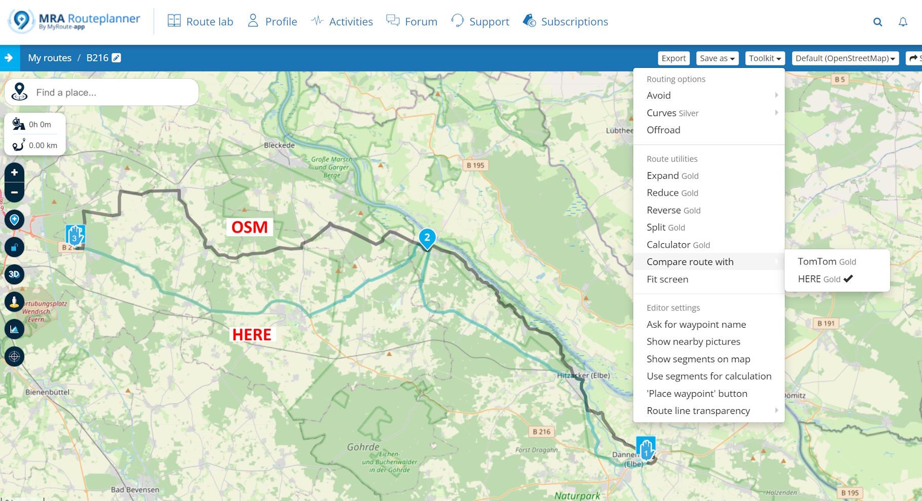
There IS a route calculated with HERE based on and on top of the OSM route. It's one of the features I love about MRA: You can navigate an OSM and a HERE route at the same time and always choose which one to follow. Super handy if you want to navigate routes and tracks that aren't in HERE.
Here is another example, have a look at the white and blue lines:
https://www.myrouteapp.com/en/social/route/12990957?mode=share
-
@Con-Hennekens said in "Route as Track" wird nicht wie geplant navigiert:
When a route that has the OSM (or TT) map set as basemap is opened in NN, it will always be opened as track, so there is no route recalculation on basis of the HERE map
There IS a route calculated with HERE based on and on top of the OSM route. It's one of the features I love about MRA: You can navigate an OSM and a HERE route at the same time and always choose which one to follow. Super handy if you want to navigate routes and tracks that aren't in HERE.
Here is another example, have a look at the white and blue lines:
https://www.myrouteapp.com/en/social/route/12990957?mode=share
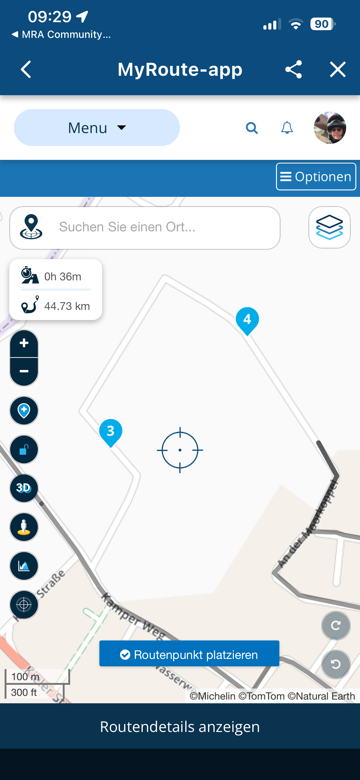
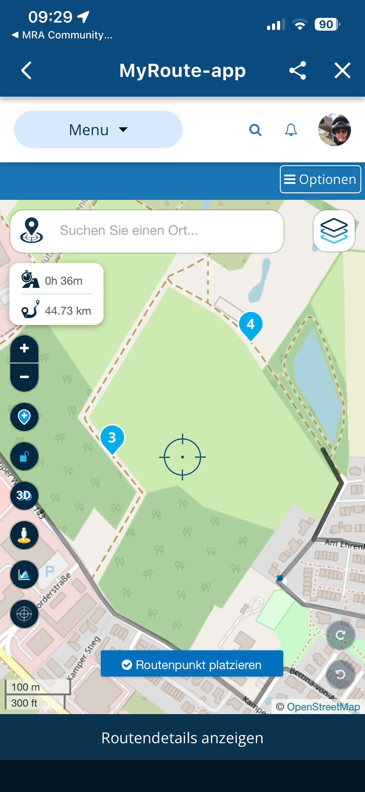
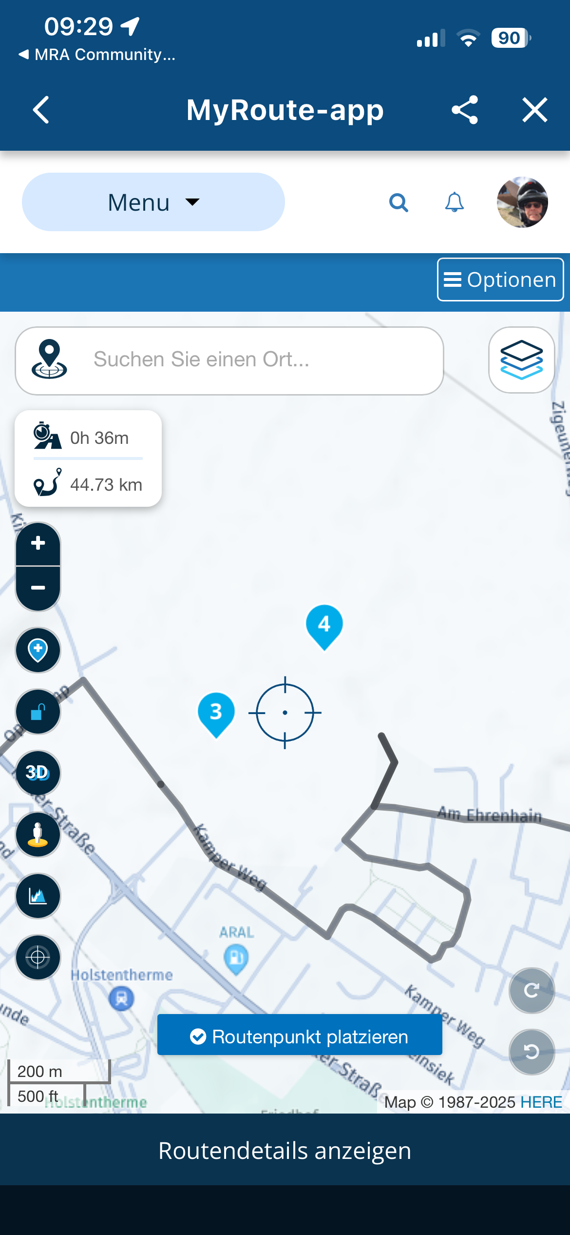
@Martin-Wilcke, You are never navigating on an OSM map, Navigation ONLY uses the HERE map. The difference in your screenshot is something that should not happen, en it does not happen with the TT map for example. In my opinion something goes wrong with opening a OSM based route on the HERE map. It looks to me that the trackconversion loses way too much resolution when exported from OSM.
I am just an enthusiastic MRA user, and hope you will be one too!
Most motorcycle problems are caused by the nut that connects the handlebar to the saddle.
Check out RideSleepRepeat.eu, a biker community for sharing stays across Europe
-
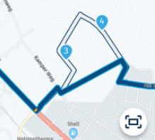
The maps differ from each other, and where OSM or Michelin is more accurate, HERE has not found a road, at least in the example.
Michelin
OSM
HERE
VG Hubert
Beta Test "Next App" dazu die Hardware .
iPad 9. Gen iOS 26.5.2/ iPhone 16e iOS 26.5/ Navi iPhone Xr iOS 18.7.9 / PC mit MS Win11 /❗️MyRoute-App im Cradel und Remotek-One❗️ Info zu MRA & Remotek One -
@Martin-Wilcke, You are never navigating on an OSM map, Navigation ONLY uses the HERE map. The difference in your screenshot is something that should not happen, en it does not happen with the TT map for example. In my opinion something goes wrong with opening a OSM based route on the HERE map. It looks to me that the trackconversion loses way too much resolution when exported from OSM.
@Con-Hennekens said in "Route as Track" wird nicht wie geplant navigiert:
You are never navigating on an OSM map, Navigation ONLY uses the HERE map.
Yes, you're right. "Navigating" in terms of getting additional information, such as TBT instructions, is always based on a route calculated with HERE.
I meant "navigating" in a wider sense: when I come to a point where the lines diverge, I can choose to follow the blue line (with instructions) or the white line (on sight).The difference in your screenshot is something that should not happen, en it does not happen with the TT map for example.
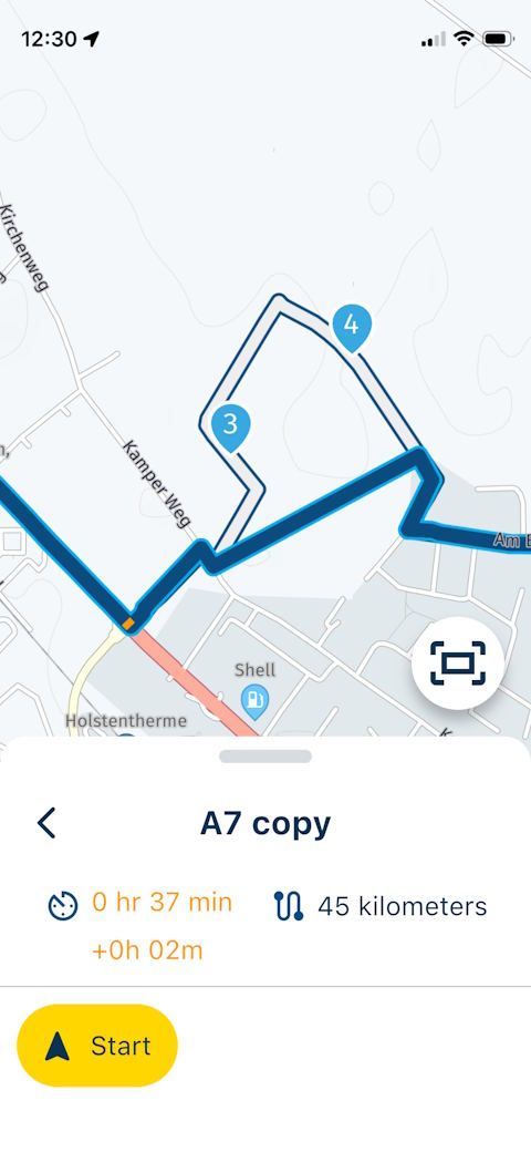
What exactly do you mean? If it's the separation on both lines in pic 2 around WP 3 & 4, it also happens when using TT instead of OSM. If I change the "Basemap" to TT in this example, the result is the same. Even if I export this route, re-import it as a route-track and start track navigation, it looks the same.
But this leads to another question: I always thought I'd only get both lines if I used "Routes as track," but I've now learned that's not necessary at all.
Can you explain the difference between starting navigation with or without "Routes as track" in this example? Is it just a matter of how, during a recalculation (when I deviate from the blue line), the route (blue line) leads back onto the track (white line)? -
The maps differ from each other, and where OSM or Michelin is more accurate, HERE has not found a road, at least in the example.
Michelin
OSM
HERE
Exactly. That's why I use OSM for planning when I want to route tracks that aren't in HERE. I used this a lot, and it always worked. It's like having a "tarmac-based backup" at hand when things go wrong on the track
")
-
@Con-Hennekens said in "Route as Track" wird nicht wie geplant navigiert:
You are never navigating on an OSM map, Navigation ONLY uses the HERE map.
Yes, you're right. "Navigating" in terms of getting additional information, such as TBT instructions, is always based on a route calculated with HERE.
I meant "navigating" in a wider sense: when I come to a point where the lines diverge, I can choose to follow the blue line (with instructions) or the white line (on sight).The difference in your screenshot is something that should not happen, en it does not happen with the TT map for example.
What exactly do you mean? If it's the separation on both lines in pic 2 around WP 3 & 4, it also happens when using TT instead of OSM. If I change the "Basemap" to TT in this example, the result is the same. Even if I export this route, re-import it as a route-track and start track navigation, it looks the same.
But this leads to another question: I always thought I'd only get both lines if I used "Routes as track," but I've now learned that's not necessary at all.
Can you explain the difference between starting navigation with or without "Routes as track" in this example? Is it just a matter of how, during a recalculation (when I deviate from the blue line), the route (blue line) leads back onto the track (white line)?@Martin-Wilcke said in "Route as Track" wird nicht wie geplant navigiert:
I meant "navigating" in a wider sense: when I come to a point where the lines diverge, I can choose to follow the blue line (with instructions) or the white line (on sight).
You are already free to make that choice yourself, aren't you?
@Martin-Wilcke said in "Route as Track" wird nicht wie geplant navigiert:
it also happens when using TT instead of OSM
No, I tested your file, and with TT as basemap it loads just like it is, and does not lead me over A7. It just chooses a different curvy (tomtom) path, but leaves it intact when navigating.
@Martin-Wilcke said in "Route as Track" wird nicht wie geplant navigiert:
I always thought I'd only get both lines if I used "Routes as track," but I've now learned that's not necessary at all.
That's a misconception. The white line just represents the original route or track. If you look at your example from message 26:
WP3 and 4 are not on navigational roads (off road paths according to HERE) so the app is trying to avoid those. Whenever there is a navigational road on the HERE map, close enough to the waypoints, it will use those.
I am just an enthusiastic MRA user, and hope you will be one too!
Most motorcycle problems are caused by the nut that connects the handlebar to the saddle.
Check out RideSleepRepeat.eu, a biker community for sharing stays across Europe
-
@Martin-Wilcke said in "Route as Track" wird nicht wie geplant navigiert:
I meant "navigating" in a wider sense: when I come to a point where the lines diverge, I can choose to follow the blue line (with instructions) or the white line (on sight).
You are already free to make that choice yourself, aren't you?
@Martin-Wilcke said in "Route as Track" wird nicht wie geplant navigiert:
it also happens when using TT instead of OSM
No, I tested your file, and with TT as basemap it loads just like it is, and does not lead me over A7. It just chooses a different curvy (tomtom) path, but leaves it intact when navigating.
@Martin-Wilcke said in "Route as Track" wird nicht wie geplant navigiert:
I always thought I'd only get both lines if I used "Routes as track," but I've now learned that's not necessary at all.
That's a misconception. The white line just represents the original route or track. If you look at your example from message 26:
WP3 and 4 are not on navigational roads (off road paths according to HERE) so the app is trying to avoid those. Whenever there is a navigational road on the HERE map, close enough to the waypoints, it will use those.
@Con-Hennekens said in "Route as Track" wird nicht wie geplant navigiert:
That's a misconception
OK - so, if I plan a route with OSM that includes tracks not in HERE (as in #26 around WP 3/4), and I open it for navigation: What is the difference between having "Routes as track" toggled on or off?
And if there is no difference, what is "Routes as track" good for? -
@Martin-Wilcke said in "Route as Track" wird nicht wie geplant navigiert:
I meant "navigating" in a wider sense: when I come to a point where the lines diverge, I can choose to follow the blue line (with instructions) or the white line (on sight).
You are already free to make that choice yourself, aren't you?
@Martin-Wilcke said in "Route as Track" wird nicht wie geplant navigiert:
it also happens when using TT instead of OSM
No, I tested your file, and with TT as basemap it loads just like it is, and does not lead me over A7. It just chooses a different curvy (tomtom) path, but leaves it intact when navigating.
@Martin-Wilcke said in "Route as Track" wird nicht wie geplant navigiert:
I always thought I'd only get both lines if I used "Routes as track," but I've now learned that's not necessary at all.
That's a misconception. The white line just represents the original route or track. If you look at your example from message 26:
WP3 and 4 are not on navigational roads (off road paths according to HERE) so the app is trying to avoid those. Whenever there is a navigational road on the HERE map, close enough to the waypoints, it will use those.
@Con-Hennekens said in "Route as Track" wird nicht wie geplant navigiert:
You are already free to make that choice yourself, aren't you?
Sure. Even if I don't navigate a route at all. But that's not the point here, right?
-
@Con-Hennekens said in "Route as Track" wird nicht wie geplant navigiert:
That's a misconception
OK - so, if I plan a route with OSM that includes tracks not in HERE (as in #26 around WP 3/4), and I open it for navigation: What is the difference between having "Routes as track" toggled on or off?
And if there is no difference, what is "Routes as track" good for?@Martin-Wilcke said in "Route as Track" wird nicht wie geplant navigiert:
OK - so, if I plan a route with OSM that includes tracks not in HERE (as in #26 around WP 3/4), and I open it for navigation: What is the difference between having "Routes as track" toggled on or off?
And if there is no difference, what is "Routes as track" good for?There will be no difference, since routes created in the OSM or TomTom map are opened as tracks anyway. The only way "route as track" does anything, is when you open a route based on HERE for navigation.
I am just an enthusiastic MRA user, and hope you will be one too!
Most motorcycle problems are caused by the nut that connects the handlebar to the saddle.
Check out RideSleepRepeat.eu, a biker community for sharing stays across Europe
-
@Martin-Wilcke said in "Route as Track" wird nicht wie geplant navigiert:
OK - so, if I plan a route with OSM that includes tracks not in HERE (as in #26 around WP 3/4), and I open it for navigation: What is the difference between having "Routes as track" toggled on or off?
And if there is no difference, what is "Routes as track" good for?There will be no difference, since routes created in the OSM or TomTom map are opened as tracks anyway. The only way "route as track" does anything, is when you open a route based on HERE for navigation.
@Con-Hennekens said in "Route as Track" wird nicht wie geplant navigiert:
The only way "route as track" does anything, is when you open a route based on HERE for navigation
Ahh, good to know.
And what is the difference then? Or, in other words, what is the difference between route navigation and track navigation?
I can't find an explanation in the manuals, and the app's info pop-up (regarding "Navigate routes as tracks") states: "Choose this when you prefer the accuracy of a track". What does it mean?
I don't want to be annoying, I just want to clarify my previous understanding.
-
@Con-Hennekens said in "Route as Track" wird nicht wie geplant navigiert:
The only way "route as track" does anything, is when you open a route based on HERE for navigation
Ahh, good to know.
And what is the difference then? Or, in other words, what is the difference between route navigation and track navigation?
I can't find an explanation in the manuals, and the app's info pop-up (regarding "Navigate routes as tracks") states: "Choose this when you prefer the accuracy of a track". What does it mean?
I don't want to be annoying, I just want to clarify my previous understanding.
@Martin-Wilcke, haha, nothing annoying to it
The difference is mainly how the auto-skip function works. When navigating a route, the auto-skip can only skip to the next route point. When you navigate a track, it looks for a "logical" re-entry point anywhere on the track. Navigating a track certainly also helps when there are offroad parts in your track.I am just an enthusiastic MRA user, and hope you will be one too!
Most motorcycle problems are caused by the nut that connects the handlebar to the saddle.
Check out RideSleepRepeat.eu, a biker community for sharing stays across Europe
-
@Martin-Wilcke, haha, nothing annoying to it
The difference is mainly how the auto-skip function works. When navigating a route, the auto-skip can only skip to the next route point. When you navigate a track, it looks for a "logical" re-entry point anywhere on the track. Navigating a track certainly also helps when there are offroad parts in your track.@Con-Hennekens said in "Route as Track" wird nicht wie geplant navigiert:
The difference is mainly how the auto-skip function works
Yeah, that was my first thought, too. Thanks for the explanation.
And, you wrote “route point,” not “waypoint” - I can't believe I'm actually seeing this
-
Thank you all. Reading along has helped me understand some of it better now; I had already suspected it, but now it's been confirmed.
-
@Con-Hennekens said in "Route as Track" wird nicht wie geplant navigiert:
The difference is mainly how the auto-skip function works
Yeah, that was my first thought, too. Thanks for the explanation.
And, you wrote “route point,” not “waypoint” - I can't believe I'm actually seeing this
@Martin-Wilcke said in "Route as Track" wird nicht wie geplant navigiert:
And, you wrote “route point,” not “waypoint” - I can't believe I'm actually seeing this
A route point actually is just a waypoint that defines a route
-
This issue has just been resolved!
No app update required, I've fixed the problem in the remote API.The OSM route is now correctly loaded by the app allowing track navigation to proceed as expected.
Hello! It looks like you're interested in this conversation, but you don't have an account yet.
Getting fed up of having to scroll through the same posts each visit? When you register for an account, you'll always come back to exactly where you were before, and choose to be notified of new replies (either via email, or push notification). You'll also be able to save bookmarks and upvote posts to show your appreciation to other community members.
With your input, this post could be even better 💗
Register Login-
0376.1k
-
314796
-
13571
-
7321.9k
-
016460
-
110214
-
0101.5k
-
017526