Navigation Option Show "Original Route" Does Not Display Consistently
-
When I load some routes for navigation the display of the "original route" beneath the planned navigation route does not conform closely to the road, it appears to straight line between some unidentifiable points
On other routes it fits very close to the road & can only be seen to deviate a small bit when the navigation app is zoomed in to its maximum setting
All the routes are planned with MRA on the PC & then navigated offline with MRA Navigation.
Some routes may then be edited in the appCould someone please explain why with some of my routes the display of the "original route" differs?
& while on the subject of the "original route" could the colour be changed from white to a much more contrasting colour?
on a bright sunny day with a washed out garmin map style selected the white "original route" is virtually impossible to see
(yes I know there are other map styles but occasionally for whatever reason my style reverts to the washed out bland garmin default colouring"BlackView BV7100, Android 12
Navigate "Routes as Tracks" in Offline mode with Offline Maps
No Wifi, no internet, no interruptions, works well -
sometimes the offset from the road for the "original route" (track) can be large
when this happens & zoomed in at a junction the "original route" (track) can sometimes overlay the entire junction so the exit roads from the junction are hidden/obscured by the overlay
This imo is borderline dangerous as instead of concentrating on the dangers of navigating the junction I am busy trying to guess which exit road from the junction the navigation system is telling me I need to take -
I had the same problem so I turned off (show original route) from settings.
Which is a shame because it is very useful to have if you decide to go on a detour and then want to get back to the original route at the nearest point. And just as a confirmation that that is the original route you planned.
I'm sure it worked fine last year and belive it was a change or update somewhere that started to cause this issue.
-
Had the same problem, turned off the app, deleted cache and restarted app and everything was fine.
-
When I load some routes for navigation the display of the "original route" beneath the planned navigation route does not conform closely to the road, it appears to straight line between some unidentifiable points
On other routes it fits very close to the road & can only be seen to deviate a small bit when the navigation app is zoomed in to its maximum setting
All the routes are planned with MRA on the PC & then navigated offline with MRA Navigation.
Some routes may then be edited in the appCould someone please explain why with some of my routes the display of the "original route" differs?
& while on the subject of the "original route" could the colour be changed from white to a much more contrasting colour?
on a bright sunny day with a washed out garmin map style selected the white "original route" is virtually impossible to see
(yes I know there are other map styles but occasionally for whatever reason my style reverts to the washed out bland garmin default colouring"@Brian-McG, I see you are using offline-mode. I suspect you have "Navigate Routes as Tracks" enabled. Tracks work best in online mode, because tracks van only be calculated online. If offline, you get a less optimal track. If offline use is a must for you, you would better disable "Route as Track".
I am just an enthusiastic MRA user, and hope you will be one too!
Most motorcycle problems are caused by the nut that connects the handlebar to the saddle.
Check out RideSleepRepeat.eu, a biker community for sharing stays across Europe
-
@Brian-McG, I see you are using offline-mode. I suspect you have "Navigate Routes as Tracks" enabled. Tracks work best in online mode, because tracks van only be calculated online. If offline, you get a less optimal track. If offline use is a must for you, you would better disable "Route as Track".
@Con-Hennekens nope, not navigating tracks & option is always disabled
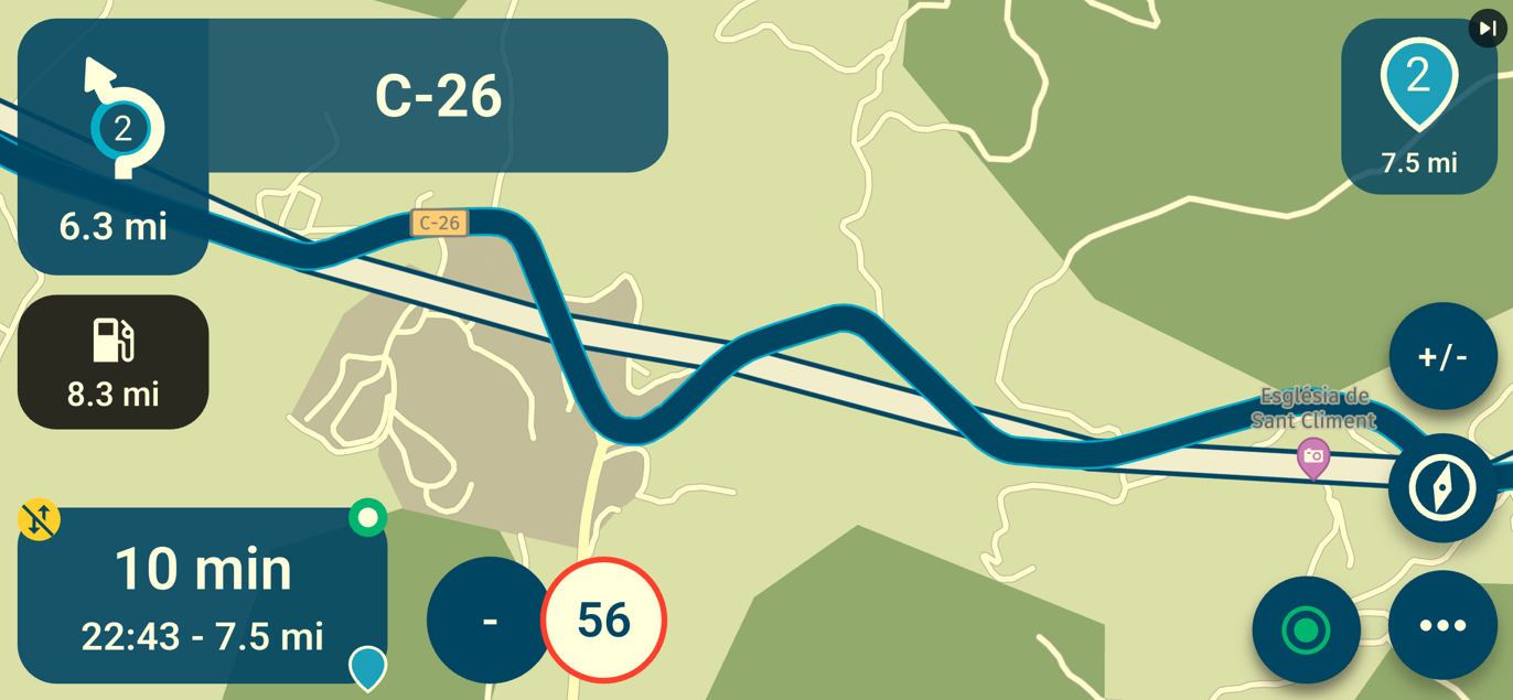
I normally navigates routes as you can see from previous post picture - blue line with multiple waypointsThe option to display the "original route" (track) is a great idea/feature, it just needs to work better (& be more visible/greater contrast on the garmin washed out style!)
others seem to be seeing a similar issue so there has to be a cause/reason -
@Brian-McG, I see you are using offline-mode. I suspect you have "Navigate Routes as Tracks" enabled. Tracks work best in online mode, because tracks van only be calculated online. If offline, you get a less optimal track. If offline use is a must for you, you would better disable "Route as Track".
@Con-Hennekens These statement confused me
because tracks van only be calculated online. If offline, you get a less optimal track.
but they did get me thinking -
I always operate in offline mode, basically airplane mode because my phone, a rugged Blackview BV6200 does not contain a sim card. It is only ever connected to internet via wifi at home or hotels when touring.So firstly if "tracks can only be calculated online" how is the "original route" (track) being calculated when I am using mra for navigation offline & how is it producing the "original route" (track)s show in my previous posts?
Secondly what does this mean "you get a less optimal track" & why?So after a bit of playing about I think I may have found something -
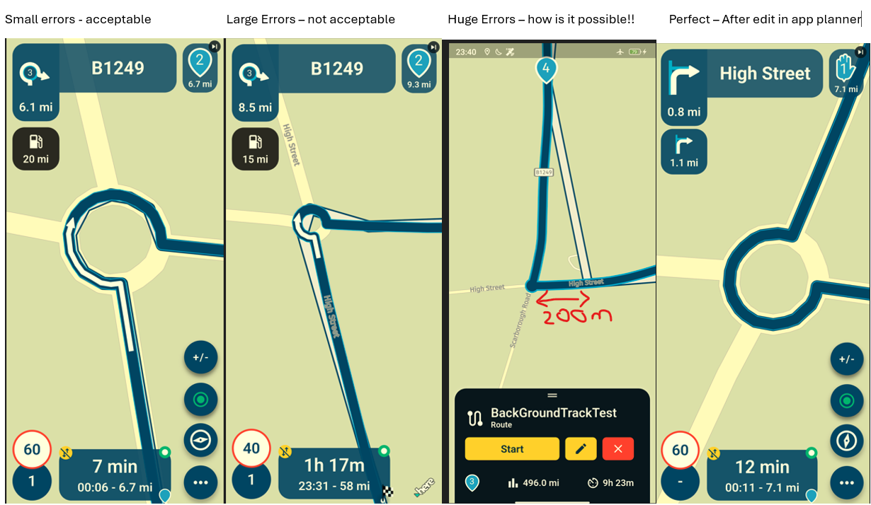
If I edit a route in the web planner or via the app website route lab link - when I try to navigate this route offline the "original route" (track) displayed in the navigation will as you say not be ""optimal"
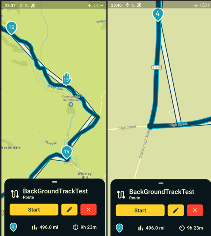
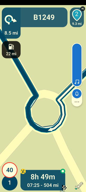
In fact they can be far from it. In the second picture the right turn at the roundabout with the track disappearing off a couple of hundred metres before is the same roundabout shown in my first post which shows very small calculation errors, in this example the track error is huge.What I have found is that if I take a route that has been created on the web planner & then edit it within the app route planner I get a different & what appears to be optimal "original route" (track)
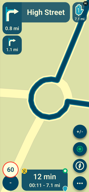
Yes this is the same round about as in the above posts but with the "original route" (track) completley hidden because it is perfectly matched to the route/roadSo my questions are why did you think the "original route" (track) in offline mode would be "less optimal"?
& why is it that when the route is edited in the app planner it appears to calculate the optimal "original route" (track)?my guess is that there is some tiny difference between the Here online map & the downloaded offline map -
this small difference upsets/causes a glitch in the calculation of the "original route" (track) such that it uses less points (sometimes a lot less points) to calculate the "original route" (track) -
a track is not a orginal route. a track is a list off points in a sequeance. so track is not fixed with a map or road. with online calculation the server connects the points and looks if there is a road or path on the map and tries to follow that. offline is less able to do that and then you get straight lines between the points. because a track has many points it seem it is following the road. for old basecamp users it was the same. if calculation was not done or offroad you also got straight lines between points.
the white line can be 2 things. if you ride a route it can be the original route and it will show if you do recalculation and route takes a new way but it will follow the road. other option it is a route based on track information and then it depends on the calculation off the server or offline in app.
-
@Brian-McG, I see you are using offline-mode. I suspect you have "Navigate Routes as Tracks" enabled. Tracks work best in online mode, because tracks van only be calculated online. If offline, you get a less optimal track. If offline use is a must for you, you would better disable "Route as Track".
@Con-Hennekens just got back from an 8days tour in The Eifel. Since réception is por over there I user offline navigation all the t8me. I’ve noticed the the original route under my actual route was mostly bespied the route. Sometimes, mostly while driving hairpins it was way Off. Could using the offline mode be cousinage this
-
The calculated route is infinitely detailed
")
Routes stored by us have a certain resolution to not take up way too much space when syncing them. This results in the minor differences so to say.The original route is a nice indicator of how you planned it so I personally would not be too bothered by it showing these minor divergences (in resolution due to missing coordinates, not actual route).
-
The calculated route is infinitely detailed
Routes stored by us have a certain resolution to not take up way too much space when syncing them. This results in the minor differences so to say.The original route is a nice indicator of how you planned it so I personally would not be too bothered by it showing these minor divergences (in resolution due to missing coordinates, not actual route).
@Corjan-Meijerink sorry the divergences of the "original route" are sometimes not minor, they are major, hundreds of metres, plus the issue is the system is not consistent
if the original route can fit to the road correctly after the route is edited in the app route planner,
why does it not fit correctly when the last edit is done on the web planner?BlackView BV7100, Android 12
Navigate "Routes as Tracks" in Offline mode with Offline Maps
No Wifi, no internet, no interruptions, works well -
@Corjan-Meijerink sorry the divergences of the "original route" are sometimes not minor, they are major, hundreds of metres, plus the issue is the system is not consistent
if the original route can fit to the road correctly after the route is edited in the app route planner,
why does it not fit correctly when the last edit is done on the web planner?@Brian-McG, are you saying that a web-planned route that shows these imperfections does NOT show those imperfections if it got last edited in the in-app planner? That would be interesting...
I am just an enthusiastic MRA user, and hope you will be one too!
Most motorcycle problems are caused by the nut that connects the handlebar to the saddle.
Check out RideSleepRepeat.eu, a biker community for sharing stays across Europe
-
@Brian-McG, are you saying that a web-planned route that shows these imperfections does NOT show those imperfections if it got last edited in the in-app planner? That would be interesting...
@Con-Hennekens yes that is what I am saying, it would be nice if someone could replicate

I am seeing the error in offline navigation
the route is edited in web planner - then synced to the device
the device is taken offline (airplane mode or wifi/network off)
the route is opened & navigation started with original route displayedsometimes the web planned route appears ok with small errors as @Corjan-Meijerink expects
other times it can have larger errors & occasionally very huge errors
if I edit the web planned route in the app planner it seems to fit perfectly
I can understand the idea of trying to save storage, reduce data & speed up transfer
if the errors were always small then I would say - not a problem
when the error is large the original track line can obscure whole junctions & makes it difficult to read the map
for me the problem is the original route is not displayed consistentlyI don't think a long term solution is to re-edit every route every time it is transferred/synced to the app
oh & don't forget the lack of contrast with a white original track
on the default garmin style map with this bug you can see nothing of the roadsBlackView BV7100, Android 12
Navigate "Routes as Tracks" in Offline mode with Offline Maps
No Wifi, no internet, no interruptions, works well -
@Con-Hennekens yes that is what I am saying, it would be nice if someone could replicate
I am seeing the error in offline navigation
the route is edited in web planner - then synced to the device
the device is taken offline (airplane mode or wifi/network off)
the route is opened & navigation started with original route displayedsometimes the web planned route appears ok with small errors as @Corjan-Meijerink expects
other times it can have larger errors & occasionally very huge errors
if I edit the web planned route in the app planner it seems to fit perfectly
I can understand the idea of trying to save storage, reduce data & speed up transfer
if the errors were always small then I would say - not a problem
when the error is large the original track line can obscure whole junctions & makes it difficult to read the map
for me the problem is the original route is not displayed consistentlyI don't think a long term solution is to re-edit every route every time it is transferred/synced to the app
oh & don't forget the lack of contrast with a white original track
on the default garmin style map with this bug you can see nothing of the roads@Brian-McG, This is a good find. Thanks for your elaborate explanation. I will try to replicate this behavior.
I am just an enthusiastic MRA user, and hope you will be one too!
Most motorcycle problems are caused by the nut that connects the handlebar to the saddle.
Check out RideSleepRepeat.eu, a biker community for sharing stays across Europe
-
@Brian-McG, This is a good find. Thanks for your elaborate explanation. I will try to replicate this behavior.
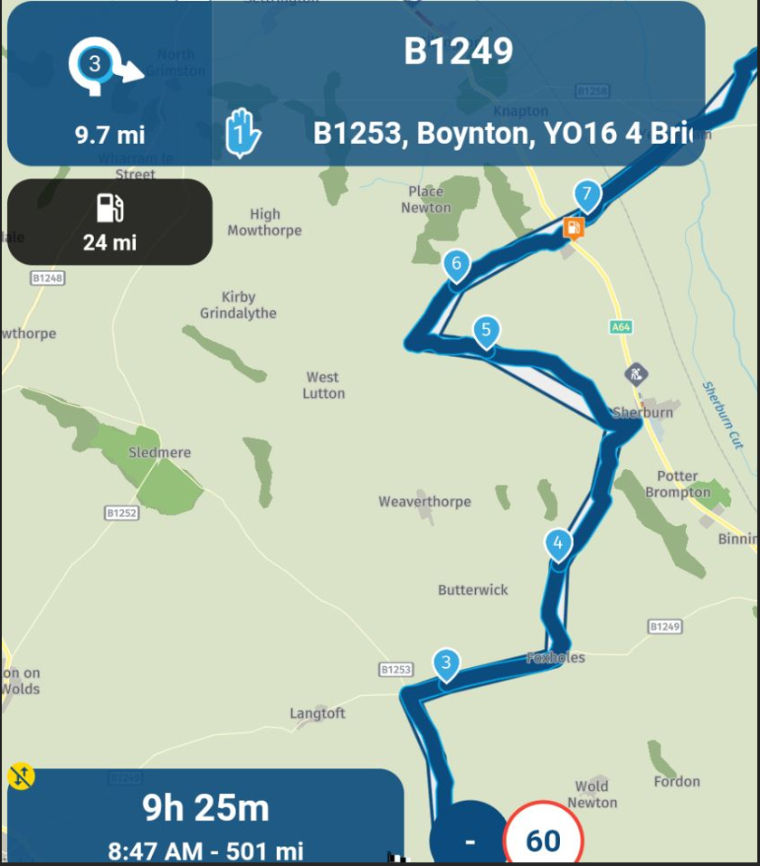
Sometimes the errors with the "original track" can be huge,
with the above route the "original route" is wrong by hundreds & hundreds of metreswhat causes the wrong calculation of the "original route" in offline mode?
I have also noticed that with a route created in the web planner,
if the navigation is started with a network connection, the "original route" will fit perfectly to the road
the same as when the route is edited in the app planner, you get a perfect fitI only seem to get the bad fit of the "original route" when I start the navigation in offline mode
BlackView BV7100, Android 12
Navigate "Routes as Tracks" in Offline mode with Offline Maps
No Wifi, no internet, no interruptions, works well -
Sometimes the errors with the "original track" can be huge,
with the above route the "original route" is wrong by hundreds & hundreds of metreswhat causes the wrong calculation of the "original route" in offline mode?
I have also noticed that with a route created in the web planner,
if the navigation is started with a network connection, the "original route" will fit perfectly to the road
the same as when the route is edited in the app planner, you get a perfect fitI only seem to get the bad fit of the "original route" when I start the navigation in offline mode
@Brian-McG, Tried to replicate this some days ago, but did not succeed... Although I have seen these straight lines before too, I was not able to replicate it in any circumstance you described. I was surprised by that and don't understand why. Old routes, new routes, offline, online, changed in the webplanner, I could not get the straight lines to appear. I'll try again later, probably after the holiday season.
-
I've seen the same behavior during my 8 days trip in the Eiffel 2 weeks ago. It was clear to see it when driving hair pins.
I was driving offline -
I think the solution is to open the route when you have wi-fi, irrespective of whether you will navigate online or offline. I had this happen to me a few weeks back, so from that point I have always opened the route with wi-fi before navigating and I haven't had the problem since.
Always willing to help if I can.
Triumph Tiger 1200 XRT called Tina.
MRA Navigation Next and SilverFox BJ8 -
I think the solution is to open the route when you have wi-fi, irrespective of whether you will navigate online or offline. I had this happen to me a few weeks back, so from that point I have always opened the route with wi-fi before navigating and I haven't had the problem since.
@Nick-Carthew my problem was that the WiFi was Shi... To
-
I think the solution is to open the route when you have wi-fi, irrespective of whether you will navigate online or offline. I had this happen to me a few weeks back, so from that point I have always opened the route with wi-fi before navigating and I haven't had the problem since.
@Nick-Carthew yes the problem only appears if you try to start to try navigating with the device offline i.e. with no internet, no wifi connection
the route must be last edited in the web plannerif you open/edit on the device with an internet/wifi/online connection, it will recalculate the "original route" & you won't see the problem
as far as I am concerned this is a definitive hard reproducible bug
I can replicate it on 3 different devices with 2 different accountsnow I know there are several work arounds, it is not so much of a big issue for me
just a pain having to go through extra steps to get things to work
but as this seems to be the norm for mra, things never quite work as expected ... hey hoBlackView BV7100, Android 12
Navigate "Routes as Tracks" in Offline mode with Offline Maps
No Wifi, no internet, no interruptions, works well
Hello! It looks like you're interested in this conversation, but you don't have an account yet.
Getting fed up of having to scroll through the same posts each visit? When you register for an account, you'll always come back to exactly where you were before, and choose to be notified of new replies (either via email, or push notification). You'll also be able to save bookmarks and upvote posts to show your appreciation to other community members.
With your input, this post could be even better 💗
Register Login-
71156.5k
-
020492
-
026455
-
0352
-
1215291
-
19565
-
0248
-
07270