Assign a via point/waypoint number
-
Hi,
is there a waypoint number reassignment option in the Route Planner?
For example, on an itinerary with 20 total points, do I want to change point 5 to 10 simply by renaming the number?
So far, I've only found a way to move the point with the mouse, but if I need to move an end point to the beginning of a long list, for example, it's a long and difficult process, especially since the list scrolls jerkily when dragging (Google Chrome).Thanks
-
As far as I know this is not possible. You can only change the colour and the description of waypoint.
But why do you want to renumber the waypoints?
| MRA Gold Member |
| Garmin Zumo XT + BMW K1200GT |
| MRA Next + Kawasaki Z650 | -
Hi,
is there a waypoint number reassignment option in the Route Planner?
For example, on an itinerary with 20 total points, do I want to change point 5 to 10 simply by renaming the number?
So far, I've only found a way to move the point with the mouse, but if I need to move an end point to the beginning of a long list, for example, it's a long and difficult process, especially since the list scrolls jerkily when dragging (Google Chrome).Thanks
@Corrado-Miniati-0 If you want to change the order of the shapingpoints/viapoints simply press and hold the one that you want to move and drag it to the place in de routepoints menu where you want it to be
-
Thanks for the advice, I'll follow your advice. Renumbering the points was convenient because moving them on the map can cause positioning errors and is extra work for the control.
Perhaps Corjan can consider this suggestion for a future update.
Thanks
-
As far as I know this is not possible. You can only change the colour and the description of waypoint.
But why do you want to renumber the waypoints?
@Nomko-Nomden said in Assign a via point/waypoint number:
But why do you want to renumber the waypoints?
I had the case the other day where after the reation of a route, I wanted to look for possible fuel stops along the way. But when I added them, they came at the end of a relative long list of shaping points, meaning I had to remember in between which points it needed to be, and then drag the new via-point up into the right position within the list.
But perhaps there is a better way to insert an additional via-point in the right spot in an existing route?
-
@Nomko-Nomden said in Assign a via point/waypoint number:
But why do you want to renumber the waypoints?
I had the case the other day where after the reation of a route, I wanted to look for possible fuel stops along the way. But when I added them, they came at the end of a relative long list of shaping points, meaning I had to remember in between which points it needed to be, and then drag the new via-point up into the right position within the list.
But perhaps there is a better way to insert an additional via-point in the right spot in an existing route?
@K-De-Weerd When you add an additional route point in between others, hover the cursor over the route line until you see a black ball, then click to add the new route point. If you need to, you can then drag the new route point to the fuel station.
Always willing to help if I can.
Triumph Tiger 1200 XRT called Tina.
MRA Navigation Next and SilverFox BJ8 -
Thanks for the advice, I'll follow your advice. Renumbering the points was convenient because moving them on the map can cause positioning errors and is extra work for the control.
Perhaps Corjan can consider this suggestion for a future update.
Thanks
@Corrado-Miniati-0 said in Assign a via point/waypoint number:
because moving them on the map can cause positioning errors and is extra work for the control.
If I understand you correctly, you're moving the points on the map?
To avoid positioning errors, you have to go to the waypoints list and drag them to the location you want them to be.
-
Hi,
is there a waypoint number reassignment option in the Route Planner?
For example, on an itinerary with 20 total points, do I want to change point 5 to 10 simply by renaming the number?
So far, I've only found a way to move the point with the mouse, but if I need to move an end point to the beginning of a long list, for example, it's a long and difficult process, especially since the list scrolls jerkily when dragging (Google Chrome).Thanks
@Corrado-Miniati-0 I try to figure out, what the need could be, to change the order of waypoints that much, so that one of the last points will be one of the first. Your whole route changes and you're driving back and forth and the route twice...
Met andere apps maak je een route, met MRA componeer je een route!
Ducati Monster 1200 met Garmin Zümo XT
Fiat 124 Spider/Camper Dethleffs met Navigation-App op Samsung Tab Active4 Pro
MRA Lifetime Gold -
@Corrado-Miniati-0 I try to figure out, what the need could be, to change the order of waypoints that much, so that one of the last points will be one of the first. Your whole route changes and you're driving back and forth and the route twice...
@Lex.Kloet.RX I think he only has this problem when he has added a point to the route in the app, which he then has to move to the correct position using the waypoint list.
Currently, I agree with his statement that moving the waypoints (opened via the route lab) is very jerky and it takes a long time to move the waypoint to the correct location.I have noticed that if you open the route via the Routes and Tracklogs menu and then open the waypoint list in the route, moving the waypoints works very quickly and smooth.
BMW R 1250 GS
MRA Navigation & SilverFox C1 Controller
DMD-NOR7E 7"
SPC Universal mount
Motorola Edge 40 "offline"
Sena SLR 3
Sena 50 R -
@Lex.Kloet.RX I think he only has this problem when he has added a point to the route in the app, which he then has to move to the correct position using the waypoint list.
Currently, I agree with his statement that moving the waypoints (opened via the route lab) is very jerky and it takes a long time to move the waypoint to the correct location.I have noticed that if you open the route via the Routes and Tracklogs menu and then open the waypoint list in the route, moving the waypoints works very quickly and smooth.
@Peter-Zehentreiter just insert a waypoint on the desired place and delete the other

 ️
️Met andere apps maak je een route, met MRA componeer je een route!
Ducati Monster 1200 met Garmin Zümo XT
Fiat 124 Spider/Camper Dethleffs met Navigation-App op Samsung Tab Active4 Pro
MRA Lifetime Gold -
@Peter-Zehentreiter just insert a waypoint on the desired place and delete the other
️@Lex.Kloet.RX What you say is true, but if he wants an extra one, it's fiddly on a cell phone.
I also move points around from time to time and use this technique.BMW R 1250 GS
MRA Navigation & SilverFox C1 Controller
DMD-NOR7E 7"
SPC Universal mount
Motorola Edge 40 "offline"
Sena SLR 3
Sena 50 R -
@Peter-Zehentreiter he mentioned "to move the point with the mouse", that is definitely not on a cell phone.
Met andere apps maak je een route, met MRA componeer je een route!
Ducati Monster 1200 met Garmin Zümo XT
Fiat 124 Spider/Camper Dethleffs met Navigation-App op Samsung Tab Active4 Pro
MRA Lifetime Gold -
@K-De-Weerd When you add an additional route point in between others, hover the cursor over the route line until you see a black ball, then click to add the new route point. If you need to, you can then drag the new route point to the fuel station.
@Nick-Carthew said in Assign a via point/waypoint number:
@K-De-Weerd When you add an additional route point in between others, hover the cursor over the route line until you see a black ball, then click to add the new route point. If you need to, you can then drag the new route point to the fuel station.
I am aware you can add shaping points like that and you can subsequently change them into via-points, but dragging the point onto the POI does not ‘snap’ it to this POI. Would be a nice way to add a via point automatically named like and with all the info of said POI
-
@Peter-Zehentreiter he mentioned "to move the point with the mouse", that is definitely not on a cell phone.
@Lex.Kloet.RX One-nil to you.
But who knows which cell phones can already be operated with a mouse these days.
BMW R 1250 GS
MRA Navigation & SilverFox C1 Controller
DMD-NOR7E 7"
SPC Universal mount
Motorola Edge 40 "offline"
Sena SLR 3
Sena 50 R -
@Lex.Kloet.RX One-nil to you.
But who knows which cell phones can already be operated with a mouse these days.@Peter-Zehentreiter said in Assign a via point/waypoint number:
But who knows which cell phones can already be operated with a mouse these days.
They all can... Just add a BT mouse.
And especially having a mouse on your tablet (or large phone) is working really great for planning")
-
@Lex.Kloet.RX One-nil to you.
But who knows which cell phones can already be operated with a mouse these days.@Peter-Zehentreiter I have a Samsung S22 Ultra with pencil, it has somewhat the same function as a mouse and works also very precise. And like @Con-Hennekens writes, you can also add a BT-mouse.
Welcome in the world of electronics (true there is a lot of electronic stuff I do not know )
 -
@Lex.Kloet.RX What you say is true, but if he wants an extra one, it's fiddly on a cell phone.
I also move points around from time to time and use this technique.@Peter-Zehentreiter on your phone you just use your finger to click on the black line (your route) to add an intermediate waypoint. Maybe he's using the add waypoint potion which then adds it to the end of the route instead of where the petrol station is. Just click on the line

-
I really appreciate all the feedback and am pleased to see the interest in the topic. I'll try to better explain the origins of my request.
From my PC on Route Lab, when I start planning a trip, I enter the coordinates of the places I'd like to visit, but without any "geographical" order. I do it randomly, following the information I find online and that I already know.
Consequently, there are points on the map that don't follow a logical order of the trip because I only do this once I've completed all the planning.
Only then do I begin to arrange the various points in a logical travel order. So far, the only way I've found is to drag the points one by one to the correct position in the "Waypoint" list with the mouse. However, if the list is very long, not all the points are visible on the screen, and dragging the mouse is time-consuming and not easy. To move a point before or after the visible list, I have to do a sort of back-and-forth with the point always clicked, otherwise the scrolling gets stuck and doesn't flow smoothly.
It would be much easier to be able to rename the points' placement, because the map immediately shows the logical order of my trip.
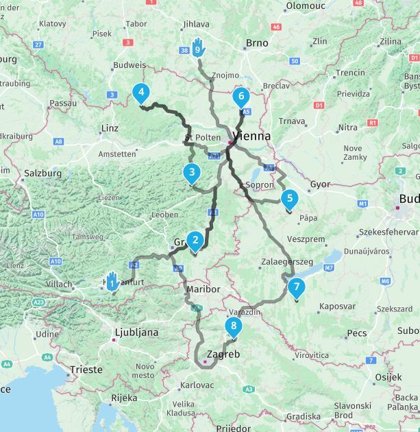
Just as an example, in the map below I've simulated a trip with just a few waypoints. It would already be obvious to me that:- waypoint 9 should become waypoint 5
- waypoint 5 should become waypoint 7
- waypoint 7 should become waypoint 8
If you're thinking of an itinerary with dozens and dozens of waypoints, then it's clear that renaming the waypoints would be a very welcome option.
I hope Corjan considers this possibility.Thanks
-
-
@Corrado-Miniati-0 I have got your point, because I do planning for journeys similar.
The system knows about the routepoint numbers and is using it for sorting the items in the list. Also the number is populated in the list item.
May it would be possible, to get the populated number as editable. I see: manual sorting of a long list will then become quicker.
Hello! It looks like you're interested in this conversation, but you don't have an account yet.
Getting fed up of having to scroll through the same posts each visit? When you register for an account, you'll always come back to exactly where you were before, and choose to be notified of new replies (either via email, or push notification). You'll also be able to save bookmarks and upvote posts to show your appreciation to other community members.
With your input, this post could be even better 💗
Register Login-
12564
-
0366.1k
-
7321.9k
-
016452
-
110200
-
312782
-
0219
-
17416