Skip to content
  • Categories
  • Recent
  • Popular
  • Support
  • MyRoute-app
Collapse
Brand Logo

MRA Community Forum

  1. Home
  2. MyRoute-app Routeplanner
  3. [Web] Suggestions and Discussion
  4. Add option for stripping shaping points in gpx export

Add option for stripping shaping points in gpx export

Scheduled Pinned Locked Moved [Web] Suggestions and Discussion
30 Posts 9 Posters 14.6k Views 3 Watching
  • Oldest to Newest
  • Newest to Oldest
  • Most Votes
Reply
  • Reply as topic
Log in to reply
This topic has been deleted. Only users with topic management privileges can see it.
  • martin-phogel.de Offline
    martin-phogel.de Offline
    martin-phogel.de
    wrote on last edited by martin-phogel.de
    #8

    @Con-Hennekens @Jörgen

    I don't think that any of the tools mentioned will help. It's not about format conversion, but about changing the content (stripping SPs).

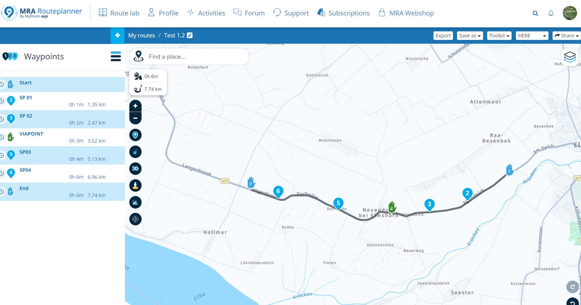
    I have created a route with both MRA-Export 1.2 and BC-Transfer (with ‘Strip-SP-Option’) and the result is almost identical (the BC-version additionally contains gpxx:subclasses, but that should be irrelevant).

    On my Zumo XT both versions behave the same. It may be different on a Garmin outdoor device, but I doubt it.
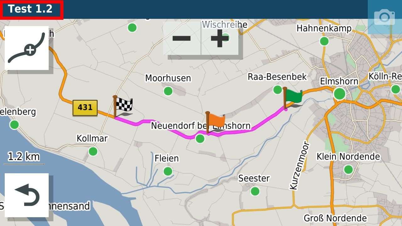
    Route.jpg

    Test MRA.jpg

    TEST BC.jpg

    Con Hennekens 1 Reply Last reply
    0
    • martin-phogel.de martin-phogel.de

      @Con-Hennekens @Jörgen

      I don't think that any of the tools mentioned will help. It's not about format conversion, but about changing the content (stripping SPs).

      I have created a route with both MRA-Export 1.2 and BC-Transfer (with ‘Strip-SP-Option’) and the result is almost identical (the BC-version additionally contains gpxx:subclasses, but that should be irrelevant).

      On my Zumo XT both versions behave the same. It may be different on a Garmin outdoor device, but I doubt it.

      Route.jpg

      Test MRA.jpg

      TEST BC.jpg

      Con Hennekens Offline
      Con Hennekens Offline
      Con Hennekens
      Alpha tester
      wrote on last edited by
      #9

      @Martin-Wilcke, My suggestion was more targetted towards the mentioned Garmin Edge. It seems that JaVaWa is able to turn GPXs into courses for the Edge. But besides that, Javawa is able to "unflag" soft waypoints, which sounds very much like the stripping you explained. But I am not really educated about that.

      I will try to import a GPX 1.2 into my Oregon later, see what happens.

      I am just an enthusiastic MRA user, and hope you will be one too!

      Most motorcycle problems are caused by the nut that connects the handlebar to the saddle.

      Check out RideSleepRepeat.eu, a biker community for sharing stays across Europe

      martin-phogel.de 1 Reply Last reply
      0
      • ConiKost Offline
        ConiKost Offline
        ConiKost
        wrote on last edited by
        #10

        Well, so many answers here. Thank you very much! I will do some tests and report back.

        Shiny!

        1 Reply Last reply
        0
        • Con Hennekens Con Hennekens

          @Martin-Wilcke, My suggestion was more targetted towards the mentioned Garmin Edge. It seems that JaVaWa is able to turn GPXs into courses for the Edge. But besides that, Javawa is able to "unflag" soft waypoints, which sounds very much like the stripping you explained. But I am not really educated about that.

          I will try to import a GPX 1.2 into my Oregon later, see what happens.

          martin-phogel.de Offline
          martin-phogel.de Offline
          martin-phogel.de
          wrote on last edited by
          #11

          @Con-Hennekens

          I'm looking forward to the result!

          Here I've stored the two route versions I created - if you like, you can also load them onto your oregon and see how they differ...

          https://hidrive.ionos.com/share/pquvtok.yw

          ConiKost 1 Reply Last reply
          1
          • GT JWR Offline
            GT JWR Offline
            GT JWR
            Valued contributor
            wrote on last edited by
            #12

            @Peter-Schiefer excercise caution doing this, as if you reduce it by too many points, that actual route planned will change.

            For me, to help avoid that from happening, I will experiment reducing the points until the route changes, then undo that change to get the route as planned, back. From there, if I feel there are still too many points, I will start to delete them individually. Again, caution needs to be used as at a certain point, the route will change if not careful.

            Good luck!

            1 Reply Last reply
            0
            • Erdna Offline
              Erdna Offline
              Erdna
              wrote on last edited by Erdna
              #13

              Hi everybody,

              interesting topic, although it doesn´t concern my use case. Hope you´ll find a solution or at least a workaround.

              Just to give an example of scale and "sustainble" use of routing points: this route is 13 days and approx. 7200 km. It uses 192 waypoints. The individual day trips have around 25 to 30 waypoints and average ca. 550 km. 🙂

              My "dirty solution" for the problem with the old Garmin would be simple: I´d build a loop. Let´s say your planning is a stop at waypoint 8, but you have no waypoints. Why not set waypoint 9 before the real stop? If you reached your planned stop, the Garmin would tell you to turn back. Not suitable for leading groups, I guess.^^

              Regards from Austria,
              André

              1 Reply Last reply
              0
              • ConiKost Offline
                ConiKost Offline
                ConiKost
                wrote on last edited by ConiKost
                #14

                All right, I did now run some tests and have so say, that I was completly wrong in my mind. The "GPX 1.2" export does work indeed. No shaping points are exported, so a route with more than 50 shaping points just works fine. The route is also correctly being shown.

                But: There seems to be an issue with Outdoor devices. All VIA points are missing and not shown. Only Start and End Point is shown, but all Via Points between are gone. This seems only be an export issue, as the VIA points are corrently shown on the MRA web route planer. I can also see those VIA points in the GPX 1.2 file, but the Montana seems just not detect them. I can reproduce that with my Montana.

                This does not happen, when using the same exported route from BaseCamp.

                I am attaching the same route

                1. Transfer with BaseCamp including Shaping Points
                2. Transfer with BaseCamp without Shaping Points
                3. Transfer GPX 1.2 from MRA to Montana

                @Hans-van-de-Ven-MR-MRA This would be an investigation worth, because if that could be fixed, we would have full support for Outdoor devices like Montana.

                The routes can be found here:
                MRA Route GPX 1.2
                BC Route with Shaping Points
                BC Route without Shaping Points

                Shiny!

                Hans van de Ven MR.MRA 1 Reply Last reply
                0
                • martin-phogel.de martin-phogel.de

                  @Con-Hennekens

                  I'm looking forward to the result!

                  Here I've stored the two route versions I created - if you like, you can also load them onto your oregon and see how they differ...

                  https://hidrive.ionos.com/share/pquvtok.yw

                  ConiKost Offline
                  ConiKost Offline
                  ConiKost
                  wrote on last edited by
                  #15

                  @Martin-Wilcke I have the same issue with your example routes. "Test BC.gpx" works correctly and shows the VIA point in the middle. With "Test 1.2.gpx", the VIA point in the middle is missing and not shown.

                  Shiny!

                  martin-phogel.de 1 Reply Last reply
                  0
                  • ConiKost ConiKost

                    @Martin-Wilcke I have the same issue with your example routes. "Test BC.gpx" works correctly and shows the VIA point in the middle. With "Test 1.2.gpx", the VIA point in the middle is missing and not shown.

                    martin-phogel.de Offline
                    martin-phogel.de Offline
                    martin-phogel.de
                    wrote on last edited by
                    #16

                    @ConiKost said in Add option for stripping shaping points in gpx export:

                    "Test BC.gpx" works correctly and shows the VIA point in the middle. With "Test 1.2.gpx", the VIA point in the middle is missing and not show

                    That's strange and I didn't expect it.

                    I have looked at the files - the differences are rather insignificant. But obviously the Montana behaves differently, because the MRA 1.2 is displayed correctly on the XT:
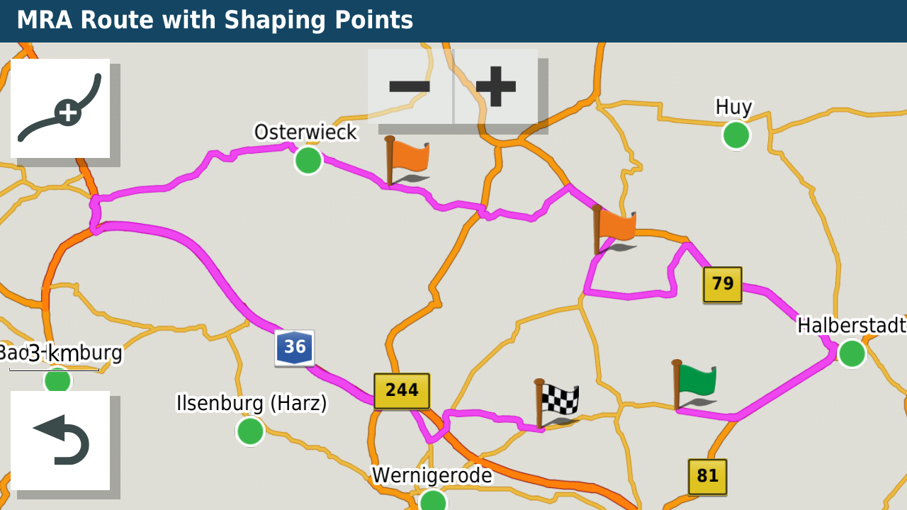
                    20647.png

                    I have made two manual changes to the MRA 1.2 to find out the secret. Can you please load the ‘MRA Route version 2’ saved here
                    https://hidrive.ionos.com/share/pquvtok.yw
                    onto your Montana and check whether one of the two Viapoints is displayed?

                    ConiKost 1 Reply Last reply
                    0
                    • martin-phogel.de martin-phogel.de

                      @ConiKost said in Add option for stripping shaping points in gpx export:

                      "Test BC.gpx" works correctly and shows the VIA point in the middle. With "Test 1.2.gpx", the VIA point in the middle is missing and not show

                      That's strange and I didn't expect it.

                      I have looked at the files - the differences are rather insignificant. But obviously the Montana behaves differently, because the MRA 1.2 is displayed correctly on the XT:

                      20647.png

                      I have made two manual changes to the MRA 1.2 to find out the secret. Can you please load the ‘MRA Route version 2’ saved here
                      https://hidrive.ionos.com/share/pquvtok.yw
                      onto your Montana and check whether one of the two Viapoints is displayed?

                      ConiKost Offline
                      ConiKost Offline
                      ConiKost
                      wrote on last edited by ConiKost
                      #17

                      @Martin-Wilcke Thanks for the new route. Unfortunately the VIA points are still missing.

                      135.jpg

                      You can see on the second image, that its just missing, there is no indicator, that there is a VIA point.
                      143.jpg

                      Shiny!

                      1 Reply Last reply
                      0
                      • martin-phogel.de Offline
                        martin-phogel.de Offline
                        martin-phogel.de
                        wrote on last edited by
                        #18

                        Astonishing.

                        Perhaps it is not due to a lack of information about the waypoints but to the definition of the route itself.

                        Would you like to investigate this issue further?
                        If so: I have changed the route again, it is now Version 3.
                        https://hidrive.ionos.com/share/pquvtok.yw
                        Can you please download it to your device?

                        If there are still no ViaPoints displayed, it would be interesting to know whether they are actually there and are just not shown or whether they have been removed.

                        Do you have the option on the device to
                        a) load the route and display the waypoints before starting the navigation? This should then look something like this:
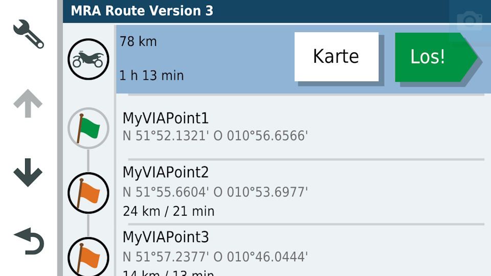
                        Bild1.jpg

                        b) start the navigation and then display the directions? Something like this:
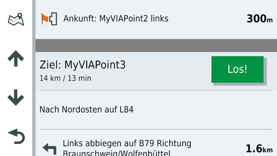
                        Bild2.jpg

                        I'm curious to see if we can track down the problem 🙂

                        Jörgen ConiKost 2 Replies Last reply
                        0
                        • martin-phogel.de martin-phogel.de

                          Astonishing.

                          Perhaps it is not due to a lack of information about the waypoints but to the definition of the route itself.

                          Would you like to investigate this issue further?
                          If so: I have changed the route again, it is now Version 3.
                          https://hidrive.ionos.com/share/pquvtok.yw
                          Can you please download it to your device?

                          If there are still no ViaPoints displayed, it would be interesting to know whether they are actually there and are just not shown or whether they have been removed.

                          Do you have the option on the device to
                          a) load the route and display the waypoints before starting the navigation? This should then look something like this:
                          Bild1.jpg

                          b) start the navigation and then display the directions? Something like this:
                          Bild2.jpg

                          I'm curious to see if we can track down the problem 🙂

                          Jörgen Offline
                          Jörgen Offline
                          Jörgen
                          Valued contributor
                          wrote on last edited by
                          #19

                          Just an idea, compare the files in an text editor to see what is different.

                          Hardware
                          iPhone 12 pro (iOS 26.2.1)
                          iPad (7.Gen.) 18.7.3
                          Oukitel RT3 Pro (Andr. 14)
                          Wireless CarPlay mit (Elebest C650)
                          Wired CarPlay (SEAT Arona - 2021)
                          MRA Workshops in Deutsch sind hier zu finden

                          martin-phogel.de 1 Reply Last reply
                          0
                          • ConiKost ConiKost

                            All right, I did now run some tests and have so say, that I was completly wrong in my mind. The "GPX 1.2" export does work indeed. No shaping points are exported, so a route with more than 50 shaping points just works fine. The route is also correctly being shown.

                            But: There seems to be an issue with Outdoor devices. All VIA points are missing and not shown. Only Start and End Point is shown, but all Via Points between are gone. This seems only be an export issue, as the VIA points are corrently shown on the MRA web route planer. I can also see those VIA points in the GPX 1.2 file, but the Montana seems just not detect them. I can reproduce that with my Montana.

                            This does not happen, when using the same exported route from BaseCamp.

                            I am attaching the same route

                            1. Transfer with BaseCamp including Shaping Points
                            2. Transfer with BaseCamp without Shaping Points
                            3. Transfer GPX 1.2 from MRA to Montana

                            @Hans-van-de-Ven-MR-MRA This would be an investigation worth, because if that could be fixed, we would have full support for Outdoor devices like Montana.

                            The routes can be found here:
                            MRA Route GPX 1.2
                            BC Route with Shaping Points
                            BC Route without Shaping Points

                            Hans van de Ven MR.MRA Offline
                            Hans van de Ven MR.MRA Offline
                            Hans van de Ven MR.MRA
                            Valued contributor
                            wrote on last edited by
                            #20

                            @ConiKost

                            The developers should dive into that as soon as they have time

                            Garmin Zumo XT3/XT2/XT/BMW Connected Ride Navigator/Tourstart/ MyRouteapp (The App)/...
                            Een dag niet gelachen is een dag niet geleefd / Een route is net zo goed als deze uitgezet is.

                            martin-phogel.de 1 Reply Last reply
                            0
                            • Jörgen Jörgen

                              Just an idea, compare the files in an text editor to see what is different.

                              martin-phogel.de Offline
                              martin-phogel.de Offline
                              martin-phogel.de
                              wrote on last edited by
                              #21

                              @Jörgen

                              Yes, that was exactly my idea. I use MS Visual Studio Code, which has a good compare feature.
                              There are a few differences between the MRA and the BC version and I'm trying to figure out which one is crucial. Unfortunately, the gpxx extensions are probably responsible for that, but they are a proprietary Garmin development and not publicly known. Most of the time you can only get to the bottom of these effects by trial and error...

                              1 Reply Last reply
                              0
                              • Hans van de Ven MR.MRA Hans van de Ven MR.MRA

                                @ConiKost

                                The developers should dive into that as soon as they have time

                                martin-phogel.de Offline
                                martin-phogel.de Offline
                                martin-phogel.de
                                wrote on last edited by
                                #22

                                @Hans-van-de-Ven-MR-MRA said in Add option for stripping shaping points in gpx export:

                                The developers should dive into that as soon as they have time

                                Of course! But perhaps we can try out a few things in advance to make it easier for the developer to analyse the problem.
                                This topic is a broad field and you can invest quite a lot of time in it.

                                1 Reply Last reply
                                0
                                • martin-phogel.de martin-phogel.de

                                  Astonishing.

                                  Perhaps it is not due to a lack of information about the waypoints but to the definition of the route itself.

                                  Would you like to investigate this issue further?
                                  If so: I have changed the route again, it is now Version 3.
                                  https://hidrive.ionos.com/share/pquvtok.yw
                                  Can you please download it to your device?

                                  If there are still no ViaPoints displayed, it would be interesting to know whether they are actually there and are just not shown or whether they have been removed.

                                  Do you have the option on the device to
                                  a) load the route and display the waypoints before starting the navigation? This should then look something like this:
                                  Bild1.jpg

                                  b) start the navigation and then display the directions? Something like this:
                                  Bild2.jpg

                                  I'm curious to see if we can track down the problem 🙂

                                  ConiKost Offline
                                  ConiKost Offline
                                  ConiKost
                                  wrote on last edited by ConiKost
                                  #23

                                  @Martin-Wilcke Thank you for your help. I am interested in further testing 🙂 Your number 3 test works, that all VIA points are now being shown. But the whole route is gone. The route is now point to point shown.
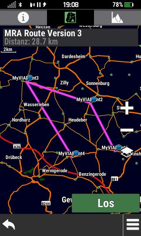
                                  MRA Route Version 3.jpg

                                  Unfortunately, the Montana route planer does not show the VIA points in a list as your Zumo does. This is a sutpid Garmin software decision, as the GPSMap 276Cx could do this and was based on Montana software.. the only option, where is does show VIA points like Zumo in a list, if I do transfer a route from Basecamp with "Direct Navigation". Thats the only case, where this works. You can find such example route here: clickme (This means only straight lines, no routing)

                                  This is can example, what I mean. It only works with my uploaded direct Route from Basecamp. Your "MRA Route Version 3", despide being direct, does not show its points, so it's apprently not detected as direct route?
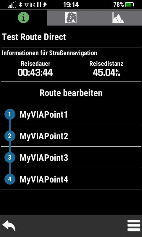
                                  Test Direct Route.jpg

                                  @Hans-van-de-Ven-MR-MRA Great, many thanks. Do you want to open for that a support ticket?

                                  Shiny!

                                  1 Reply Last reply
                                  0
                                  • martin-phogel.de Offline
                                    martin-phogel.de Offline
                                    martin-phogel.de
                                    wrote on last edited by
                                    #24

                                    @Peter-Schiefer

                                    Thanks for the link, I‘ll check it out!

                                    1 Reply Last reply
                                    0
                                    • martin-phogel.de Offline
                                      martin-phogel.de Offline
                                      martin-phogel.de
                                      wrote on last edited by
                                      #25

                                      @ConiKost

                                      OK - here comes the next and hopefully final attempt (Version 4):
                                      https://hidrive.ionos.com/share/pquvtok.yw

                                      This version contains all the additional information from the BC file, which either has static values or can be derived relatively easily.

                                      I'm curious to see if it works!

                                      1 Reply Last reply
                                      0
                                      • martin-phogel.de Offline
                                        martin-phogel.de Offline
                                        martin-phogel.de
                                        wrote on last edited by
                                        #26

                                        @ConiKost

                                        ooops, little bug in version 4, please use version 5.

                                        ConiKost 1 Reply Last reply
                                        0
                                        • martin-phogel.de martin-phogel.de

                                          @ConiKost

                                          ooops, little bug in version 4, please use version 5.

                                          ConiKost Offline
                                          ConiKost Offline
                                          ConiKost
                                          wrote on last edited by
                                          #27

                                          @Peter-Schiefer Thanks, I will have a look.

                                          @Martin-Wilcke Thank you. I tried V5 and Unfortunately no change. Still missing VIA points.
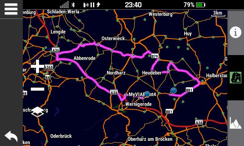
                                          Shiny!

                                          martin-phogel.de Canario 2 Replies Last reply
                                          0

                                          Hello! It looks like you're interested in this conversation, but you don't have an account yet.

                                          Getting fed up of having to scroll through the same posts each visit? When you register for an account, you'll always come back to exactly where you were before, and choose to be notified of new replies (either via email, or push notification). You'll also be able to save bookmarks and upvote posts to show your appreciation to other community members.

                                          With your input, this post could be even better 💗

                                          Register Login
                                          Reply
                                          • Reply as topic
                                          Log in to reply
                                          • Oldest to Newest
                                          • Newest to Oldest
                                          • Most Votes


                                          • 1
                                          • 2
                                          ACTIVE USERS
                                          Con Hennekens
                                          Con Hennekens
                                          ConiKost
                                          ConiKost
                                          martin-phogel.de
                                          martin-phogel.de
                                          Hans van de Ven MR.MRA
                                          Hans van de Ven MR.MRA
                                          Jörgen
                                          Jörgen
                                          GT JWR
                                          GT JWR
                                          Erdna
                                          Erdna
                                          Canario
                                          Canario
                                          POPULAR TOPICS
                                          • Is there a way to put a Home button in the program
                                            Travellexxie
                                            Travellexxie
                                            0
                                            8
                                            108

                                          • routepunten overslaan gebeurd niet zoals verwacht
                                            g.bolijn 1 0
                                            g.bolijn 1 0
                                            1
                                            23
                                            678

                                          • Route doesn’t recalculate to my destination
                                            Stevedo 6 0
                                            Stevedo 6 0
                                            0
                                            8
                                            293

                                          • Google maps and Streetview
                                            Stevedo 6 0
                                            Stevedo 6 0
                                            1
                                            13
                                            620

                                          • Is there a way to re-order the routes in your routes folder?
                                            superg
                                            superg
                                            0
                                            3
                                            61

                                          • MRA 5.2.2 (489) Route time is calculated incorrectly /// Strecken Zeit wird falsch berechnet
                                            Nick Carthew
                                            Nick Carthew
                                            0
                                            4
                                            32

                                          • Opening Route Direct from Android Auto Screen
                                            LennyO
                                            LennyO
                                            0
                                            7
                                            285

                                          • MRA In the BMW - Cradel vertically and horizontally /// MRA im BMW - Cradel senkrecht und waagerecht nutzen
                                            Hubert Thoring
                                            Hubert Thoring
                                            0
                                            2
                                            52

                                          MY GROUPS
                                          • Login

                                          • Login or register to search.
                                          • First post
                                            Last post
                                          0
                                          • Categories
                                          • Recent
                                          • Popular
                                          • Support
                                          • MyRoute-app