Skip to content
  • Categories
  • Recent
  • Popular
  • Support
  • MyRoute-app
Collapse
Brand Logo

MRA Community Forum

  1. Home
  2. The MyRoute-app
  3. [App] Problems, Bugs and other Issues
  4. Online map settings

Online map settings

Scheduled Pinned Locked Moved [App] Problems, Bugs and other Issues
19 Posts 4 Posters 702 Views 2 Watching
  • Oldest to Newest
  • Newest to Oldest
  • Most Votes
Reply
  • Reply as topic
Log in to reply
This topic has been deleted. Only users with topic management privileges can see it.
  • MartinW MartinW

    @peter-zehentreiter

    Ok, danke für die Infos!
    Letzte Frage: wie sieht es denn aus, wenn du eine solche Fahrrad-Route navigierst?

    Peter Zehentreiter
    Peter Zehentreiter
    Peter Zehentreiter
    wrote last edited by
    #10

    @MartinW Ich hab mich auf einen virtuellen Trip begeben um Deine Frage zu beantworten.

    https://1drv.ms/f/c/94b7ec629bb8bee5/IgBzCVGHUkkaTqPT4waxqaf9AZfJPI8Eilwru7xQtttBd5A?e=Rlr5Vg
    BMW R 1250 GS
    MRA Navigation & SilverFox C1 Controller
    DMD-NOR7E 7"
    SPC Universal mount
    Motorola Edge 40 "offline"
    Sena SLR 3
    Sena 50 R

    MartinW 1 Reply Last reply
    0
    • Peter Zehentreiter Peter Zehentreiter

      @MartinW Ich hab mich auf einen virtuellen Trip begeben um Deine Frage zu beantworten.

      https://1drv.ms/f/c/94b7ec629bb8bee5/IgBzCVGHUkkaTqPT4waxqaf9AZfJPI8Eilwru7xQtttBd5A?e=Rlr5Vg

      MartinW
      MartinW
      MartinW
      wrote last edited by
      #11

      @Peter-Zehentreiter

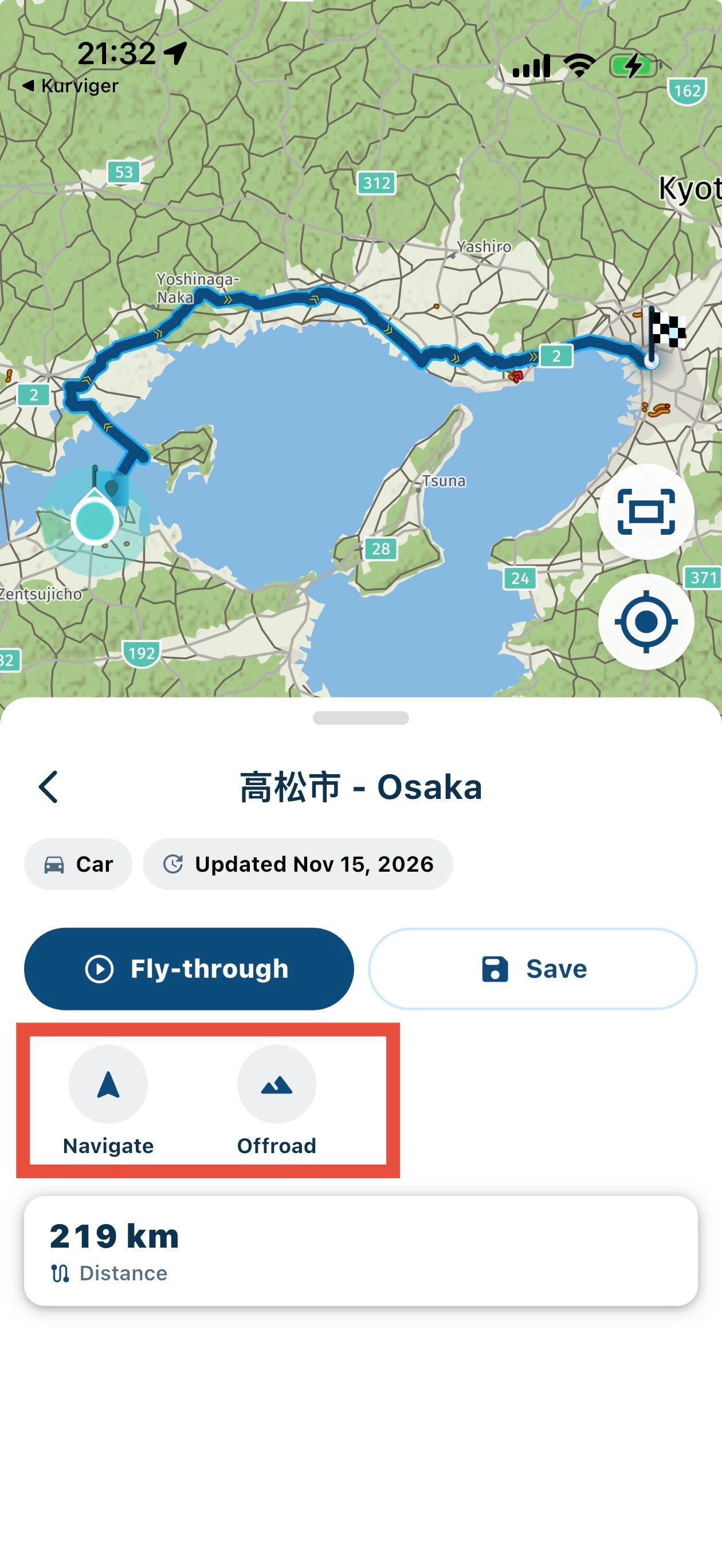
      Das mp4 zeigt einen fly-through - mich interessiert hauptsächlich, wie die echte Navigation aussieht. Gibt es TBT Anweisungen oder geht das nur als off-road Navigation?
      IMG_3099.jpeg

      Peter Zehentreiter 1 Reply Last reply
      0
      • MartinW MartinW

        @Peter-Zehentreiter

        Das mp4 zeigt einen fly-through - mich interessiert hauptsächlich, wie die echte Navigation aussieht. Gibt es TBT Anweisungen oder geht das nur als off-road Navigation?
        IMG_3099.jpeg

        Peter Zehentreiter
        Peter Zehentreiter
        Peter Zehentreiter
        wrote last edited by
        #12

        @MartinW Dazu müsste ich jetzt eine Route abfahren... ist mir persönlich aber heute zu kalt .

        Ich hab noch ein kurzes Video gemacht (ist im vorherigen Ordner abgelegt) wo Du sehen kannst das ich die Route gestartet habe und dann die weiteren Optionen aufgemacht, zumindest dort werden Sprachansagen gemäß der Einstellungen angezeigt und die Routenführung zeigt die Entfernung bis zum Ziel an und warnt Dich wenn Du die Route verlassen solltest.

        BMW R 1250 GS
        MRA Navigation & SilverFox C1 Controller
        DMD-NOR7E 7"
        SPC Universal mount
        Motorola Edge 40 "offline"
        Sena SLR 3
        Sena 50 R

        1 Reply Last reply
        0
        • MartinW MartinW

          @BertM

          Yes, some kind of auto-assignment of a map type according to the route type.

          But how does it work?
          Not while navigating:
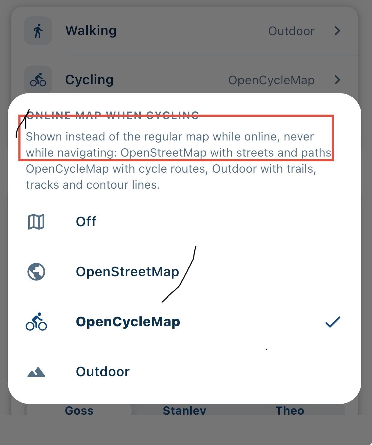
          IMG_3080.jpeg

          And if I create a new route, I can't select bicycle as the route type:

          IMG_3081.jpeg

          Could you please provide more details on how to use it?

          BertM
          BertM
          BertM
          wrote last edited by
          #13

          @MartinW said:

          @BertM

          Yes, some kind of auto-assignment of a map type according to the route type.

          But how does it work?
          Not while navigating:

          And if I create a new route, I can't select bicycle as the route type:
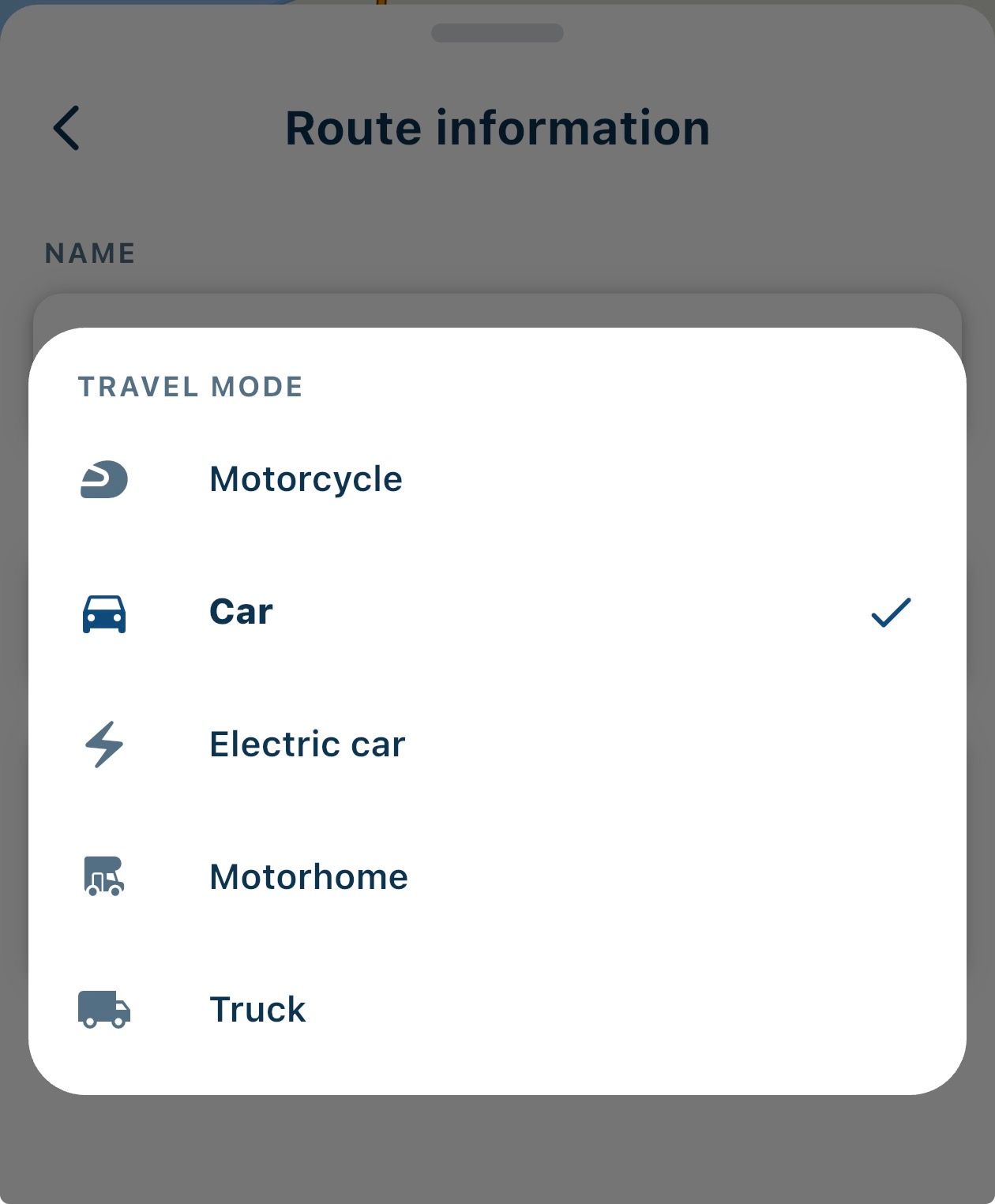
          No, creating a route in the app is only is possible on the Here map, and does not support bicycle, only car and motorbike

          Could you please provide more details on how to use it?

          If you have a route from your libary made for bicyle it will open the selected map. If you have outdoor selected for hiking it selects this map. It will then use this map for navigating the route

          MartinW 1 Reply Last reply
          0
          • BertM BertM

            @MartinW said:

            @BertM

            Yes, some kind of auto-assignment of a map type according to the route type.

            But how does it work?
            Not while navigating:

            And if I create a new route, I can't select bicycle as the route type:

            No, creating a route in the app is only is possible on the Here map, and does not support bicycle, only car and motorbike

            Could you please provide more details on how to use it?

            If you have a route from your libary made for bicyle it will open the selected map. If you have outdoor selected for hiking it selects this map. It will then use this map for navigating the route

            MartinW
            MartinW
            MartinW
            wrote last edited by
            #14

            @BertM @peter-zehentreiter

            Thanks!

            That's exactly what I expected: I can create hiking/cycling routes in OSM using the new beta planner and navigate them with NN V6, where the map automatically switches according to the settings mentioned above. I get basic info on the remaining distance while navigating (”off-road mode”), but no TBTs.

            Since NN V6 is limited to the HERE routing engine, that's likely the best we can get.

            1 Reply Last reply
            0
            • BertM
              BertM
              BertM
              wrote last edited by
              #15

              @martinw
              Your understanding is correct. I must admit that i struggled to understand the above also, but @nick-carthew helped me on that 😉
              I hope the new planner has some improvements for cycling. (I do not participate in the Beta).

              I do not use NN on the bicycle, but use a Garmin Edge. I like the web planner and use that one to create my cycling routes, the GPX of the track I then convert to a Garmin TCX or FIT file with turn alerts with a little tool I made.

              1 Reply Last reply
              0
              • Herman Veldhuizen
                Herman Veldhuizen
                Herman Veldhuizen
                wrote last edited by Herman Veldhuizen
                #16

                HERE does support pedestrian and cycling mode. That is I think what you get when you "navigate" (walk) a foot or (cycle) a cycling route.

                BertM 1 Reply Last reply
                0
                • Herman Veldhuizen Herman Veldhuizen

                  HERE does support pedestrian and cycling mode. That is I think what you get when you "navigate" (walk) a foot or (cycle) a cycling route.

                  BertM
                  BertM
                  BertM
                  wrote last edited by
                  #17

                  @Herman-Veldhuizen said:

                  HERE does support pedestrian and cycling mode. That is I think what you get when you "navigate" (walk) a foot or (cycle) a cycling route.

                  correct, but you cannot plan routes in NN

                  MartinW 1 Reply Last reply
                  0
                  • BertM BertM

                    @Herman-Veldhuizen said:

                    HERE does support pedestrian and cycling mode. That is I think what you get when you "navigate" (walk) a foot or (cycle) a cycling route.

                    correct, but you cannot plan routes in NN

                    MartinW
                    MartinW
                    MartinW
                    wrote last edited by
                    #18

                    @BertM [sagte](/post/89
                    correct, but you cannot plan routes in NN

                    Exactly. Cross-platform editing still works only for routes with one of HERE’s standard travelling modes.

                    1 Reply Last reply
                    0
                    • Herman Veldhuizen
                      Herman Veldhuizen
                      Herman Veldhuizen
                      wrote last edited by Herman Veldhuizen
                      #19

                      If I only use the app and only the Here maps (no "online" map), both for planning and navigation, I am not working cross platform. In that case I don't see a reason why editing should not be allowed.

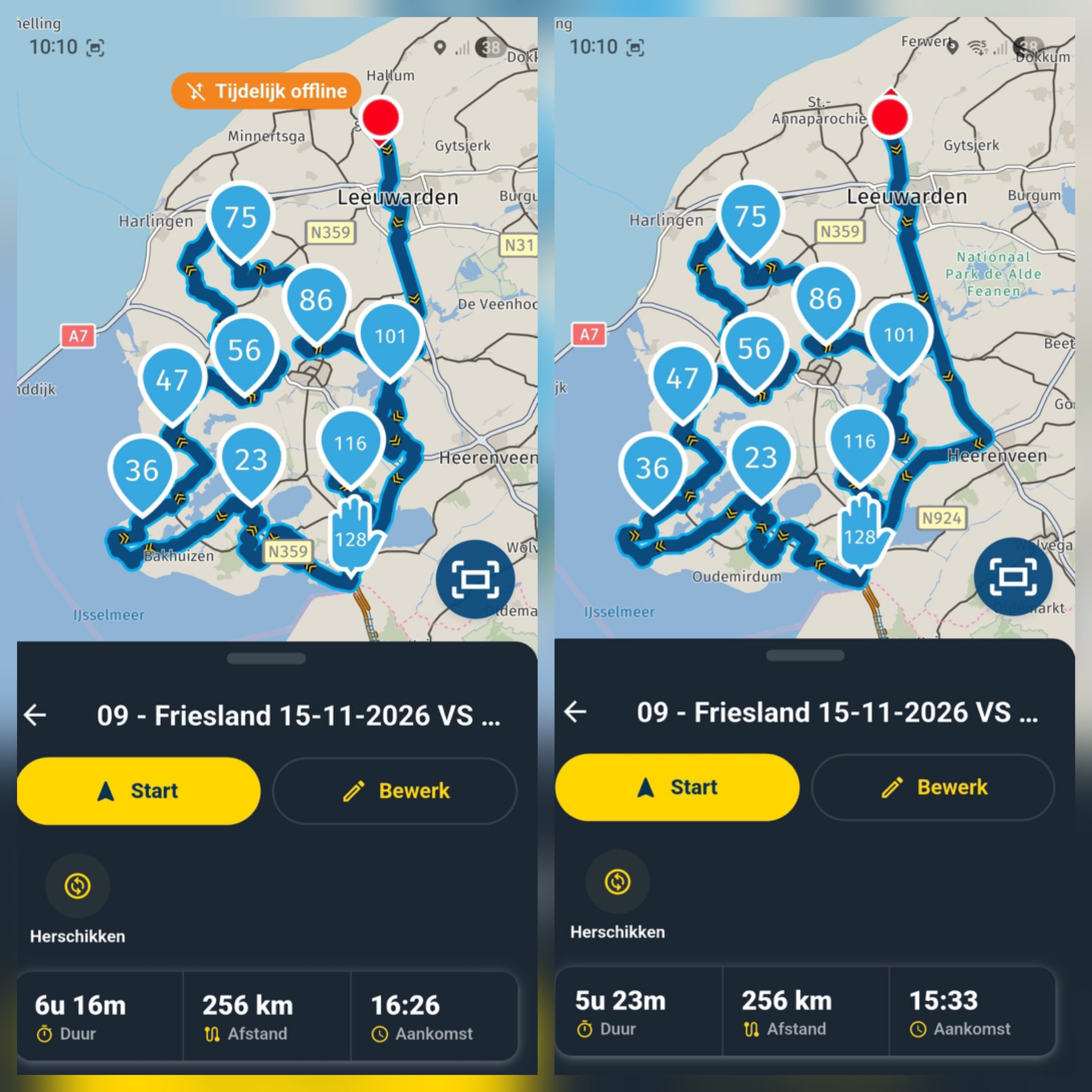
                      Here is an example.

                      The first picture shows my walking route through a city. Perfectly ok and made by the app.
                      The second one shows the route with the travel mode car. But the only way to make the first is though the second : by using the travel car for editing. The route becomes a walking route by changing the travel mode to foot, after editing.
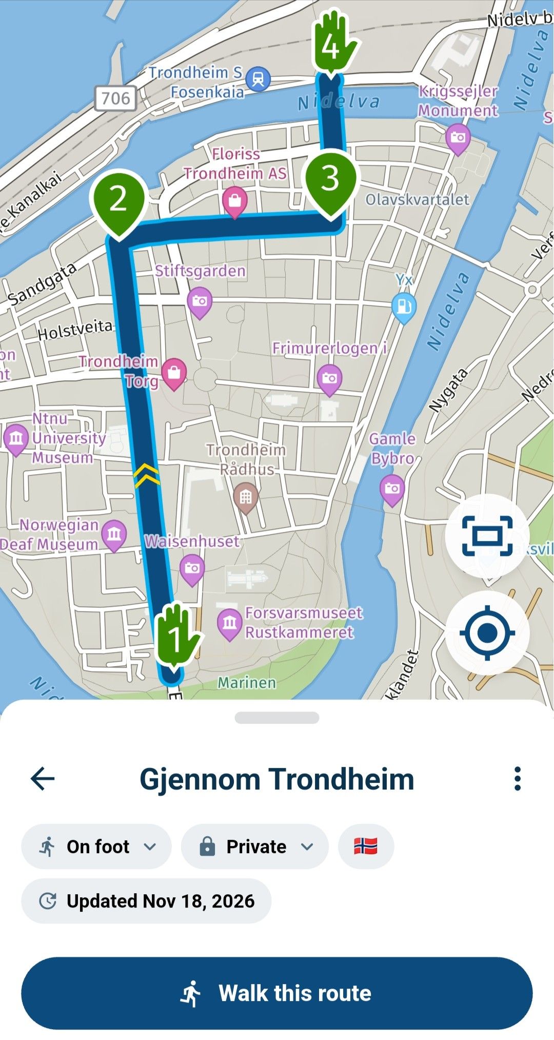
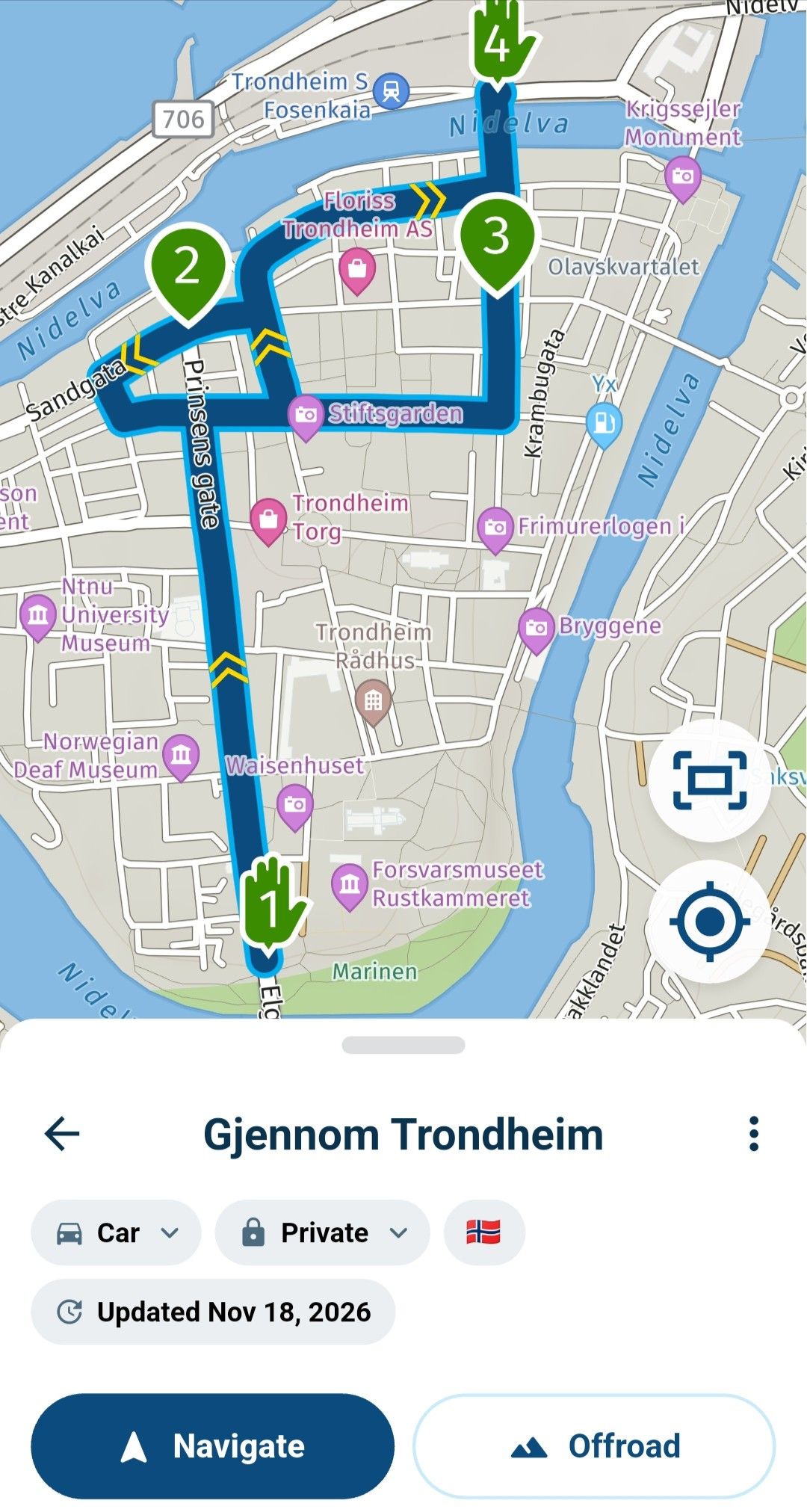
                      1000014752.jpg

                      1000014751.jpg

                      1 Reply Last reply
                      0

                      Hello! It looks like you're interested in this conversation, but you don't have an account yet.

                      Getting fed up of having to scroll through the same posts each visit? When you register for an account, you'll always come back to exactly where you were before, and choose to be notified of new replies (either via email, or push notification). You'll also be able to save bookmarks and upvote posts to show your appreciation to other community members.

                      With your input, this post could be even better 💗

                      Register Login
                      Reply
                      • Reply as topic
                      Log in to reply
                      • Oldest to Newest
                      • Newest to Oldest
                      • Most Votes


                      ACTIVE USERS
                      Herman Veldhuizen
                      Herman Veldhuizen
                      MartinW
                      MartinW
                      BertM
                      BertM
                      Peter Zehentreiter
                      Peter Zehentreiter
                      POPULAR TOPICS
                      • Website update - Send to your phone, POIs in clubs, search on the map and more
                        Guzzist
                        Guzzist
                        9
                        4
                        56

                      • The menu option “Continue with your last route” is missing
                        Axel Lange
                        Axel Lange
                        0
                        4
                        25

                      • Moving a Trip or Event to a Club?
                        Corjan Meijerink
                        Corjan Meijerink
                        0
                        4
                        21

                      • In het kort......
                        Corjan Meijerink
                        Corjan Meijerink
                        0
                        4
                        31

                      • Difference in online and offline
                        MotoCon
                        MotoCon
                        0
                        4
                        141

                      • Route probleem
                        Corjan Meijerink
                        Corjan Meijerink
                        0
                        4
                        53

                      • Route in planner komt niet overeen met app
                        Jack 13
                        Jack 13
                        0
                        13
                        162

                      • Scenic Route Generator - Weather Information
                        Corjan Meijerink
                        Corjan Meijerink
                        0
                        4
                        63

                      MY GROUPS
                      • Login

                      • Login or register to search.
                      • First post
                        Last post
                      0
                      • Categories
                      • Recent
                      • Popular
                      • Support
                      • MyRoute-app