Navigating with a track or navigating with a route?
-
For me this blog has slightly answered some of the advantages and disadvantages of Route, Tracks and Track Logs, I'm still not 100% clear how this affects me in my own real world scenario.
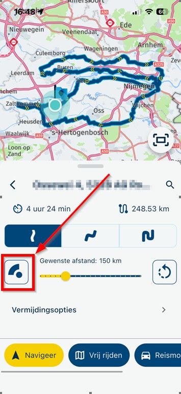
I often produce routes in MRA for a tour group which then gets distributed out (by GPX) to other riders just before a trip. The other riders have a range of different Navigation devices including TomTom Rider, Garmin Zumo, TomTomGo etc. I want to be able to provide them with a route, provided to them in the most optimal way that gives them the best experience which closely follows the route as originally intended. The reality is that while riding the route others follow different instructions that there device has told them to take and they end up getting lost. My Solution to this is to provide them with the stop locations (location name and What3Words ref) and telling them 'if you get lost, abandon the route and navigate to the stop location so we can regroup'.
Could there be a table provided in the 'Manuals' listing the different devices showing the critical steps necessary to make sure they end up with the optimal route which then allows them to be confident that they will follow the same route as it was originally designed on MRA Planner.
While GPX file is the most convenient method of route distribution I appreciate it most probably doesn't provide the best experience for all the different devices being used.
Many thanks
David Rudgley@davidrudgley-net said in Navigating with a track or navigating with a route?:
While GPX file is the most convenient method of route distribution I appreciate it most probably doesn't provide the best experience for all the different devices being used.
As far as I know GPX is the only common and generic method of sharing routes. What it does not share however is route optimization and routing settings that ere used in the planner (things like quickest or shortest, no highways, no unpaved roads). That means that calculation of the route depends on the settings on the device itself. Many people forget that, and even "official" tour planners forget to share that information, making it very difficult for riders to re-calculate the route the same way it was planned.
Besides that, a GPX can contain many things: routes, waypoints, POI and tracks, all in the same file.
I am just an enthusiastic MRA user, and hope you will be one too!
Most motorcycle problems are caused by the nut that connects the handlebar to the saddle.
Check out RideSleepRepeat.eu, a biker community for sharing stays across Europe
-
@Bouke-Ent waarom zou je geen instructies kunnen krijgen? Dat hangt zoals gezegd helemaal af van de software/app/het apparaat dat je gebruikt. MRA Navigation en TomTom Go werken gewoon op tracks, TomTom inderdaad zelfs uitsluitend.
Een route is ook alleen maar een reeks GPS-coordinaten, die niet gekoppeld zijn aan een kaart. Het gaat om de interpretatie daarvan door de navigatiesoftware/-app/-apparaat.
@Herko-ter-Horst said in Navigating with a track or navigating with a route?:
@Bouke-Ent waarom zou je geen instructies kunnen krijgen? Dat hangt zoals gezegd helemaal af van de software/app/het apparaat dat je gebruikt. MRA Navigation en TomTom Go werken gewoon op tracks, TomTom inderdaad zelfs uitsluitend.
Een route is ook alleen maar een reeks GPS-coordinaten, die niet gekoppeld zijn aan een kaart. Het gaat om de interpretatie daarvan door de navigatiesoftware/-app/-apparaat.
je kan het ook zo zien.
ik zie een track als een kruimelspoor die overal kan lopen ook waar geen wegen zijn. een route is in mijn beleving iets waar langs je navigeer de punten die volg je dan. het navigatie systeem maak er dan op basis van een kaart er instructies van. ik heb ook een tomtom 500 en die werkt niet met een track. in mijn geval gaat mydrive of de 500 zelf proberen er een route van te maken met alleen vormingspunten. zit er dan bv een stukje offroad of fietspad tussen dan krijg ik een omweg. mijn zumo doet het zelfde.
misschien bedoelen we het zelfde maar praten we even langs elkaar.
-
@Herko-ter-Horst said in Navigating with a track or navigating with a route?:
@Bouke-Ent waarom zou je geen instructies kunnen krijgen? Dat hangt zoals gezegd helemaal af van de software/app/het apparaat dat je gebruikt. MRA Navigation en TomTom Go werken gewoon op tracks, TomTom inderdaad zelfs uitsluitend.
Een route is ook alleen maar een reeks GPS-coordinaten, die niet gekoppeld zijn aan een kaart. Het gaat om de interpretatie daarvan door de navigatiesoftware/-app/-apparaat.
je kan het ook zo zien.
ik zie een track als een kruimelspoor die overal kan lopen ook waar geen wegen zijn. een route is in mijn beleving iets waar langs je navigeer de punten die volg je dan. het navigatie systeem maak er dan op basis van een kaart er instructies van. ik heb ook een tomtom 500 en die werkt niet met een track. in mijn geval gaat mydrive of de 500 zelf proberen er een route van te maken met alleen vormingspunten. zit er dan bv een stukje offroad of fietspad tussen dan krijg ik een omweg. mijn zumo doet het zelfde.
misschien bedoelen we het zelfde maar praten we even langs elkaar.
@Bouke-Ent said in Navigating with a track or navigating with a route?:
ik zie een track als een kruimelspoor die overal kan lopen ook waar geen wegen zijn.
Dat is het ook, maar dat betekent nog niet dat daar geen instructies mogelijk zijn. Daar waar geen wegen zijn krijg je inderdaad geen instructies. Maar volgens mij zijn er ook off-road systemen die wèl gewoon instructies geven, speciaal aangepast aan off-road rijden. Ook jouw zumo rijdt gewoon een track zonder vormingspunten als je de track hebt geconverteerd naar trip. Zet hercalculatie maar eens aan en rij van de track af, dan pas maakt-ie er een route van (naar het eind...)
")
-
@davidrudgley-net said in Navigating with a track or navigating with a route?:
While GPX file is the most convenient method of route distribution I appreciate it most probably doesn't provide the best experience for all the different devices being used.
As far as I know GPX is the only common and generic method of sharing routes. What it does not share however is route optimization and routing settings that ere used in the planner (things like quickest or shortest, no highways, no unpaved roads). That means that calculation of the route depends on the settings on the device itself. Many people forget that, and even "official" tour planners forget to share that information, making it very difficult for riders to re-calculate the route the same way it was planned.
Besides that, a GPX can contain many things: routes, waypoints, POI and tracks, all in the same file.
@Con-Hennekens In an ideal world I get my fellow riders to all use MRA Navigation Next... Unfortunately they are reluctant having already invested in their own method of navigating whether that be TomTom Rider, Garmin Zumo etc.
The next best thing, I provide them with is the route/track, transferred by the most reliable means (Device connector, GPX.x.xx version) whatever suits their device the best which then results in them following the route closely as originally intended.
On a recent tour through Europe one of the riders in the group was given the route GPX file and if it wasn't for being able to see his fellow riders ahead he was being directed differently to everyone else.
So in summary, riders tell me what their device is, I tell them exactly what steps they need to follow which then provides them with a route that they can rely on. I just need to know the optimum applicable to each device.
Regards
David RMRA Gold Planner + App + Navigation Next user
Android Pixel 9 Pro XL
TomTomGo as backupKTM 1290 Super Adventure S
Quad Lock + Phone +Carpuride W702KTM 790 Duke
Quad Lock + Phone -
@Con-Hennekens In an ideal world I get my fellow riders to all use MRA Navigation Next... Unfortunately they are reluctant having already invested in their own method of navigating whether that be TomTom Rider, Garmin Zumo etc.
The next best thing, I provide them with is the route/track, transferred by the most reliable means (Device connector, GPX.x.xx version) whatever suits their device the best which then results in them following the route closely as originally intended.
On a recent tour through Europe one of the riders in the group was given the route GPX file and if it wasn't for being able to see his fellow riders ahead he was being directed differently to everyone else.
So in summary, riders tell me what their device is, I tell them exactly what steps they need to follow which then provides them with a route that they can rely on. I just need to know the optimum applicable to each device.
Regards
David R@davidrudgley-net Or you make shure that the route you provide is the same for Here, TomTom and OSM so they can use it on all systems, That'swhat we call an RouteXpert proof route.
Honda Goldwing GL1500,
Honda Silverwing GL 650
DMD2 T865X 8 inch Android tablet using MRA next for navigation
Garmin XT sold
Samsung S24FE mounted on a Quadlock and using Android Auto in my car -
@davidrudgley-net Or you make shure that the route you provide is the same for Here, TomTom and OSM so they can use it on all systems, That'swhat we call an RouteXpert proof route.
@Marinus-van-Deudekom Yes I understand that, but for example do I suggest to the TomTom Rider users to use the Connector App, if so what export option do they use?? is the Connector App method better than providing them with a GPX file, is there a version of the GPX that is better than another? or is it better to transfer through 'Save As' using the TomTom MyDrive log in??
MRA Gold Planner + App + Navigation Next user
Android Pixel 9 Pro XL
TomTomGo as backupKTM 1290 Super Adventure S
Quad Lock + Phone +Carpuride W702KTM 790 Duke
Quad Lock + Phone -
@davidrudgley-net Or you make shure that the route you provide is the same for Here, TomTom and OSM so they can use it on all systems, That'swhat we call an RouteXpert proof route.
@Marinus-van-Deudekom Just to add, I put a lot of hard work into getting the routes accurate, I make sure all WP's are on the road and positioned correctly away from roundabouts, junction etc. I check between the three maps TomTom, Here and OSM making all necessary corrections and I ensure that there are plenty of WP's, expanding the quantity where necessary. Having done all this on my last tour we still had problems with riders getting lost due to differences in directions between devices. If I can eliminate these differences by advising riders the 'best practice' import process we can hopefully avoid these issues.
If the answer is... you just have to live with the inaccuracies because the export process is never going to be 100% accurate every time then so be it, at least I can manage expectations.
MRA Gold Planner + App + Navigation Next user
Android Pixel 9 Pro XL
TomTomGo as backupKTM 1290 Super Adventure S
Quad Lock + Phone +Carpuride W702KTM 790 Duke
Quad Lock + Phone -
@Marinus-van-Deudekom Yes I understand that, but for example do I suggest to the TomTom Rider users to use the Connector App, if so what export option do they use?? is the Connector App method better than providing them with a GPX file, is there a version of the GPX that is better than another? or is it better to transfer through 'Save As' using the TomTom MyDrive log in??
@davidrudgley-net if they don’t use MRA and you orovide them an gpx file it’s Out of your hands and control. I would vive them an gpx 1.1 file because that can be used on all devices but there’s no real way of telling what will hapen to you carefully planned route once a dedicated device gets it ckaws into it.
Most likely there Will be diverences Between the routes on different devices. If they got lost like you said something else has gone wrong. -
@Marinus-van-Deudekom Just to add, I put a lot of hard work into getting the routes accurate, I make sure all WP's are on the road and positioned correctly away from roundabouts, junction etc. I check between the three maps TomTom, Here and OSM making all necessary corrections and I ensure that there are plenty of WP's, expanding the quantity where necessary. Having done all this on my last tour we still had problems with riders getting lost due to differences in directions between devices. If I can eliminate these differences by advising riders the 'best practice' import process we can hopefully avoid these issues.
If the answer is... you just have to live with the inaccuracies because the export process is never going to be 100% accurate every time then so be it, at least I can manage expectations.
@davidrudgley-net, The method of transfer is in my view not important. Whether they get the route through GPX, the connector or whatever should not matter. Good practice is to always plan your routes the same way. Leave route optimization on quickest, and all allowed roads enabled. At least in the final stage. Of course you can disable unpaved or highways in planning stage, but rework your route to be identical with everything allowed. Instruct your riders to allow all roads too. Ithink that is best practise to ensure everyone gets the best result. You can export your GPX with track, that way riders cab check for themselves if the route is going according to how it was planned.
-
Let's be very clear right away, we from MyRoute-app and as lovers of making routes and recreational touring, are big fans of riding a route with waypoints, especially via our own navigation app MRA Navigation Next. In this blog I explain why we prefer riding a route rather than a track with MRA Navigation Next.
So the question when should the good idea be implemented "Suppolation to improve route navigation" s. Blog
Good morning Michael,
A question about the timeline in this project, because yesterday there was spontaneously exactly that again.
Quickly click to the goal and go, only my friend and so it goes probably many others do not know exactly this difference.
-
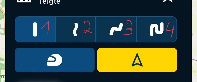
Route = 1 straight course
-
Track = Track 2,3,4 Rich In Curves
Many also probably very many customers of the MRA Think you drive at curves (2,3,4) also a route. Who's reading a manual?
This is what happened:
The click was a track = track (2) to the goal and it came as it had to come, he came off the track without consciously doing it and he was asked to drive back for an infinitely long time via the announcement and screen. He was frustrated and unhappy because he was leading in front.
After a spontaneous gas stop, I drove at the front again, but I tried to explain it to him briefly, he grabbed the helmet and just shook his head ...
Even in the evening with beer it has led to a longer discussion. ...
Also die Frage wann soll die Gute Idee denn umgesetzt werden „Vorschlag zur Verbesserung der Streckennavigation“ s. Blog
Guten Morgen Michael,
eine Frage zum zeitlichen Ablauf in diesem Projekt, denn gestern gab es spontan wieder genau das.Schnell klick zum Ziel und los, nur mein Freund und so geht es wohl sehr viele andere kennen genau diesen Unterschied nicht.
- Route = 1 gerader Verlauf
- Strecke = Track 2,3,4 Kurvenreich
Viele auch wohl sehr viele Kunden der MRA Denke Sie fahren bei Kurvenreich (2,3,4) auch eine Route, wer liest schon ein Handbuch.
Das ist passiert:
Der Klick war eine Strecke = Track (2) zum Ziel und es kam wie es kommen musste, er kam ab von der Strecke ohne es bewusst zu tun und er wurde über die Ansage und Bildschirm unendlich lange gebeten zurück zu fahren. Er war frustriert und unglücklich denn er fuhr vorne.
Nach einem spontanen Tankstop bin ich dann doch wieder vorne gefahren, habe versucht ihm das aber kurz zu erklärt, er fasste sich an den Helm und schüttelte nur noch den Kopf …
Auch Abends beim Bier hat es zu einer längeren Diskussion geführt. …
-
Hello! It looks like you're interested in this conversation, but you don't have an account yet.
Getting fed up of having to scroll through the same posts each visit? When you register for an account, you'll always come back to exactly where you were before, and choose to be notified of new replies (either via email, or push notification). You'll also be able to save bookmarks and upvote posts to show your appreciation to other community members.
With your input, this post could be even better 💗
Register Login-
723202
-
04121
-
08157
-
0321
-
0493
-
0250
-
024642
-
0252