gpx 1.1 vs 1.2
-
I have a question regarding exporting gps files from MRA to Garmin XT2....and how the XT2 reshapes routes differently with the two file types.
My workflow is to create my routes using MRA on my laptop, then export them from the MRA app on my iPhone to Garmin Tread. This then automatically syncs the routes with the Garmin XT2 (which is a pretty cool feature).
I use named Via points, and quite a few additional shaping points to define the routes.
If I export to Tread using the gps 1.2 formate, then it appears that all shaping points are lost and the XT2 simply routes directly between the Via points - which basically loses all the lovely twisty roads I have lovingly crafted the route around.
The workaround is to turn all shaping points into Vias - but this is not a good solution as you then end up with loads of confusingly named Via points.
However, if I export to Tread as gps 1.1, then the routes come across normally with all the shaping points intact and the XT routes perfectly.
I have read somewhere on a Zumo users forum, that in the case of the gps 1.2 format, MRA actually does not export the shaping points, but instead sends many (hundreds?) "ghost points", (route extensions?). It appears that the Zumo XT2 ignores these completely.
Does anyone know if this is correct - and why it works this way?
I am currently just exporting using px 1.1 which works just fine, but I am intrigued as to why gpx 1.2 works this way and doesn't include shaping points?
@Alasdair-Denton-Miller hi
Of you search on the forum you can have a great time reading about all the pro’s and con’s. There’s more then enough said about this topic -
Well, I am not sure that there is quite enough said about it yet because the Garmin Zumo XT2 nav, using the Garmin Tread app behaves differently than the older XT.
Using the same route created in MRA, sent to both the XT (via Drive) and the XT2 (via Tread) in gps 1.2 format, the route calculation is completely different.
For example, I have a great 120 mile circular route around the lower part of the Black Forest. If I export it in 1.2 to the XT, then the device follows the track, connects all the Vias and everything is good.
But if I export the same route in 1.2 via Tread, to the XT2, it simply goes for the shortest route between Vias. It does not follow the track at all, and as 1.2 does not contain shaping points, the route just follows the shortest, most boring roads.
So there is clearly something different going on with Tread/XT2 than Drive/XT. The 1.2 format that had benefits with the XT is now a liability with the XT2.
I know I can just send 1.1 format routes to the XT2 and use my shaping points, but it's also nice to be able to see the route and track at the same time and see any deviations from the plan.
-
Well, I am not sure that there is quite enough said about it yet because the Garmin Zumo XT2 nav, using the Garmin Tread app behaves differently than the older XT.
Using the same route created in MRA, sent to both the XT (via Drive) and the XT2 (via Tread) in gps 1.2 format, the route calculation is completely different.
For example, I have a great 120 mile circular route around the lower part of the Black Forest. If I export it in 1.2 to the XT, then the device follows the track, connects all the Vias and everything is good.
But if I export the same route in 1.2 via Tread, to the XT2, it simply goes for the shortest route between Vias. It does not follow the track at all, and as 1.2 does not contain shaping points, the route just follows the shortest, most boring roads.
So there is clearly something different going on with Tread/XT2 than Drive/XT. The 1.2 format that had benefits with the XT is now a liability with the XT2.
I know I can just send 1.1 format routes to the XT2 and use my shaping points, but it's also nice to be able to see the route and track at the same time and see any deviations from the plan.
@Alasdair-Denton-Miller hi @Alasdair-Denton-Miller
You are completely right. The 2 devices act differently.
What I true to say was that there are multiple topics in the Forum addressing just this problem.
Some say to solution is not using the tread app because it's nooit stable enough.
The only one that can give you a real good advice is @hans-van-de-ven. Of you can search the Forum for XT2 exportHonda Goldwing GL1500,
Honda Silverwing GL 650
DMD2 T865X 8 inch Android tablet using MRA next for navigation
Garmin XT sold
Samsung S24FE mounted on a Quadlock and using Android Auto in my car -
@Alasdair-Denton-Miller hi @Alasdair-Denton-Miller
You are completely right. The 2 devices act differently.
What I true to say was that there are multiple topics in the Forum addressing just this problem.
Some say to solution is not using the tread app because it's nooit stable enough.
The only one that can give you a real good advice is @hans-van-de-ven. Of you can search the Forum for XT2 export@Marinus-van-Deudekom I did some testing last night and found the following:
-
I made a detailed route in Tread with multiple shaping points. I transferred this to my Zumo XT2, which then took the route from 400 miles to 900 miles!
-
I tried to rectify the issue for hours over days to no avail. Turns out the Tread app is just useless.
-
I then decided to use MyRouteApp - MUCH, MUCH, MUCH better than Tread. I have then planned my route again, including 153 shaping points.
3.1. Go to the MRA app, export using GPX 1.2, import into Tread. Tread then imports 2 tracks, instead of a track and a route.
3.2. Go to MRA app, export GPX 1.1 - route and track imported into Tread. Route takes the fastest route between start and end point disregarding shaping points.
3.3. MRA app, export GPX 1.1, import into Explore. Route and track imported. Both displayed perfectly. Route includes all the shaping points. However, when opened in Tread to then transfer to Zumo, Tread than reverts to the position at 3.2 and removes all shaping points.
3.4. MRA website, export GPX 1.1, connect Zumo XT2 to Mac and use Android File Transfer to share the GPX file to the device. Route ONLY imported, no track. GPX is displayed correctly, and includes all shaping points.
I've emailed this to Garmin and will await their response.
KTM 1290 Super Adventure S
-
-
@Marinus-van-Deudekom I did some testing last night and found the following:
-
I made a detailed route in Tread with multiple shaping points. I transferred this to my Zumo XT2, which then took the route from 400 miles to 900 miles!
-
I tried to rectify the issue for hours over days to no avail. Turns out the Tread app is just useless.
-
I then decided to use MyRouteApp - MUCH, MUCH, MUCH better than Tread. I have then planned my route again, including 153 shaping points.
3.1. Go to the MRA app, export using GPX 1.2, import into Tread. Tread then imports 2 tracks, instead of a track and a route.
3.2. Go to MRA app, export GPX 1.1 - route and track imported into Tread. Route takes the fastest route between start and end point disregarding shaping points.
3.3. MRA app, export GPX 1.1, import into Explore. Route and track imported. Both displayed perfectly. Route includes all the shaping points. However, when opened in Tread to then transfer to Zumo, Tread than reverts to the position at 3.2 and removes all shaping points.
3.4. MRA website, export GPX 1.1, connect Zumo XT2 to Mac and use Android File Transfer to share the GPX file to the device. Route ONLY imported, no track. GPX is displayed correctly, and includes all shaping points.
I've emailed this to Garmin and will await their response.
@Sam-Ellis the Tread app is awful. It does not seem to matter what I do, there always seems to be a problem with the route being changed to a lesser or greater degree by the sync action between the Tread App and the XT2 and vice versa. Generally, I stick with making changes on the XT2 as the backward sync to Tread appears to be more reliable. That said, converting a track to a route seems to be the safest option at the moment but then you lose the via points.
Lost patience with the Tread and XT2 and using MRA on a CarPlay display on the bike now. So much more easier.
-
-
@Marinus-van-Deudekom I did some testing last night and found the following:
-
I made a detailed route in Tread with multiple shaping points. I transferred this to my Zumo XT2, which then took the route from 400 miles to 900 miles!
-
I tried to rectify the issue for hours over days to no avail. Turns out the Tread app is just useless.
-
I then decided to use MyRouteApp - MUCH, MUCH, MUCH better than Tread. I have then planned my route again, including 153 shaping points.
3.1. Go to the MRA app, export using GPX 1.2, import into Tread. Tread then imports 2 tracks, instead of a track and a route.
3.2. Go to MRA app, export GPX 1.1 - route and track imported into Tread. Route takes the fastest route between start and end point disregarding shaping points.
3.3. MRA app, export GPX 1.1, import into Explore. Route and track imported. Both displayed perfectly. Route includes all the shaping points. However, when opened in Tread to then transfer to Zumo, Tread than reverts to the position at 3.2 and removes all shaping points.
3.4. MRA website, export GPX 1.1, connect Zumo XT2 to Mac and use Android File Transfer to share the GPX file to the device. Route ONLY imported, no track. GPX is displayed correctly, and includes all shaping points.
I've emailed this to Garmin and will await their response.
@Sam-Ellis Hi
I see that you also use the explore app.
My experience is that explore wel surely mess everything you want to do.
I advise you the set the XT2 to factory settings install it again and don't use explore.
Look at how @hans-van-de-ven is using the tread app and maybe it will end alrightHonda Goldwing GL1500,
Honda Silverwing GL 650
DMD2 T865X 8 inch Android tablet using MRA next for navigation
Garmin XT sold
Samsung S24FE mounted on a Quadlock and using Android Auto in my car -
-
@Sam-Ellis Hi
I see that you also use the explore app.
My experience is that explore wel surely mess everything you want to do.
I advise you the set the XT2 to factory settings install it again and don't use explore.
Look at how @hans-van-de-ven is using the tread app and maybe it will end alright@Marinus-van-Deudekom I have to use Explore for other Garmin outdoor devices I use that don't support anything else. I'll check out Hans and see how it goes.
KTM 1290 Super Adventure S
-
@Marinus-van-Deudekom I have to use Explore for other Garmin outdoor devices I use that don't support anything else. I'll check out Hans and see how it goes.
@Sam-Ellis for your XT2 make sure that it isn’t on the XT2
-
@Marinus-van-Deudekom I did some testing last night and found the following:
-
I made a detailed route in Tread with multiple shaping points. I transferred this to my Zumo XT2, which then took the route from 400 miles to 900 miles!
-
I tried to rectify the issue for hours over days to no avail. Turns out the Tread app is just useless.
-
I then decided to use MyRouteApp - MUCH, MUCH, MUCH better than Tread. I have then planned my route again, including 153 shaping points.
3.1. Go to the MRA app, export using GPX 1.2, import into Tread. Tread then imports 2 tracks, instead of a track and a route.
3.2. Go to MRA app, export GPX 1.1 - route and track imported into Tread. Route takes the fastest route between start and end point disregarding shaping points.
3.3. MRA app, export GPX 1.1, import into Explore. Route and track imported. Both displayed perfectly. Route includes all the shaping points. However, when opened in Tread to then transfer to Zumo, Tread than reverts to the position at 3.2 and removes all shaping points.
3.4. MRA website, export GPX 1.1, connect Zumo XT2 to Mac and use Android File Transfer to share the GPX file to the device. Route ONLY imported, no track. GPX is displayed correctly, and includes all shaping points.
I've emailed this to Garmin and will await their response.
@Sam-Ellis
UPDATEAfter a bit more digging, I've now found that I can export GPX 1.1 in MRA, and import into Tread and it will keep the shaping points, so long as the total number of waypoints in MRA is 50 or less. Any more than that, and it imports both the route and track as tracks.
-
-
I'm also still trying to find the best way of using MRA/Tread/XT2. Tread will definitely not play nicely with gpx1.2 is the first thing - it's purely a MRA file that nails a route to your track in the Zumo. The shaping points are stripped so Tread will build its own route using whatever parameters are set within the app.
However, you can transfer gpx1.2 via cable but now I'm finding Tread will sometimes mess with those routes after a sync. I suppose a check before departure that your MRA route and Tread agree might stop this but what a faff. A quick workaround if you're on tour and it happens is to delete the route, re-import (as it should still be there if you haven't done another cable transfer), make sure it overlays your track then start the route immediately before another potentially route destroying sync.
gpx1.1: This is the file of choice and seems to work a lot of the time. Enough Shaping and/or Via points need to be used so that Tread builds exactly the same route as MRA otherwise your XT2 may refuse to calculate the route, though sometimes it will! I'm not over keen on Via points as if you don't go to them, the Zumo will try to route you back there. There is a 'skip' option but that can totally destroy the rest of your route. With both the above files, you will also be sent your track. As others have mentioned in previous posts, it's a really good idea to widen the track and put it in a visible collection where you can see any route deviations. Bright red for the track seems to show well in the XT2.
You can simply follow the Track or even create a route from it which will be accurate but you then lose any Via points you may have added. Fine a lot of the time.
I would like to be able to export my MRA routes in gpx1.1 via both cable when at home and Tread whilst away without Tread destroying all the good work. It would be great if you could only sync what and when you want. Disabling Tread means you lose everything else it provides. It's a Garmin problem, I know .By the way, if you haven't read elsewhere, you can now leave auto-recalculate switched on with gpx1.1 and it will bring you back to your route if you deviate. gpx1.2 will do similar but seems to prefer turning you around and sending you miles back to a previous point.
Apologies if this is all stuff you know but I'd love to hear any other suggestions anyone has to make MRA (or any other imported pre-built GPX route) and Tread play nicely all the time.
@Carl-Lee
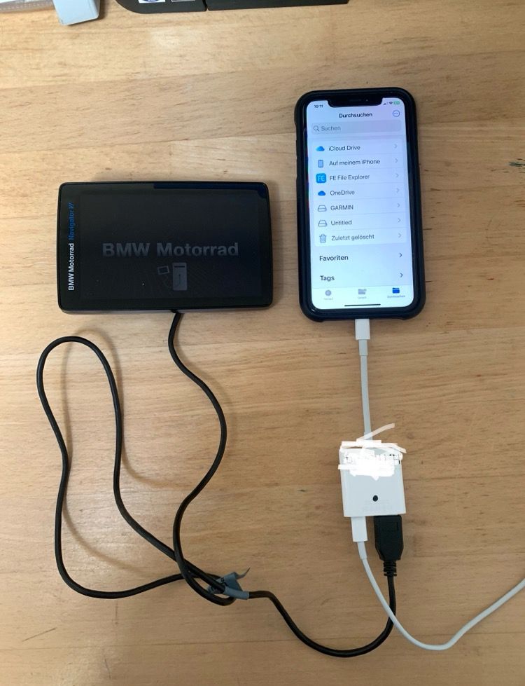
Hey, try copying it from your phone to the XT2 with a cable when you're on the go. It works with the BMW N6 navigation system, (iPhone Xr) see picture.File on the N6 on the Garmin internal memory in the /GPX folder
File on the additional memory card in the /Garmin / GPX folder
Hey versuche das doch mal für unterwegs, vom Handy mit Kable an den XT2 zu kopieren, beim BMW-Navi N6 geht es mit einem (iPhone Xr) s. Bild.
Datei beim N6 auf dem Garmin internen Speicher in Ordner /GPX
Datei auf die zusätzliche Speicherkarte unter Ordner /Garmin / GPXs. Bild !
VG Hubert
Beta Test "Next App" dazu die Hardware .
iPad 9. Gen iOS 26.5.2/ iPhone 16e iOS 26.5.2/ Navi iPhone Xr iOS 18.7.9 / PC mit MS Win11 /❗️MyRoute-App im Cradel und Remotek-One❗️ Info zu MRA & Remotek One -
I'm also still trying to find the best way of using MRA/Tread/XT2. Tread will definitely not play nicely with gpx1.2 is the first thing - it's purely a MRA file that nails a route to your track in the Zumo. The shaping points are stripped so Tread will build its own route using whatever parameters are set within the app.
However, you can transfer gpx1.2 via cable but now I'm finding Tread will sometimes mess with those routes after a sync. I suppose a check before departure that your MRA route and Tread agree might stop this but what a faff. A quick workaround if you're on tour and it happens is to delete the route, re-import (as it should still be there if you haven't done another cable transfer), make sure it overlays your track then start the route immediately before another potentially route destroying sync.
gpx1.1: This is the file of choice and seems to work a lot of the time. Enough Shaping and/or Via points need to be used so that Tread builds exactly the same route as MRA otherwise your XT2 may refuse to calculate the route, though sometimes it will! I'm not over keen on Via points as if you don't go to them, the Zumo will try to route you back there. There is a 'skip' option but that can totally destroy the rest of your route. With both the above files, you will also be sent your track. As others have mentioned in previous posts, it's a really good idea to widen the track and put it in a visible collection where you can see any route deviations. Bright red for the track seems to show well in the XT2.
You can simply follow the Track or even create a route from it which will be accurate but you then lose any Via points you may have added. Fine a lot of the time.
I would like to be able to export my MRA routes in gpx1.1 via both cable when at home and Tread whilst away without Tread destroying all the good work. It would be great if you could only sync what and when you want. Disabling Tread means you lose everything else it provides. It's a Garmin problem, I know .By the way, if you haven't read elsewhere, you can now leave auto-recalculate switched on with gpx1.1 and it will bring you back to your route if you deviate. gpx1.2 will do similar but seems to prefer turning you around and sending you miles back to a previous point.
Apologies if this is all stuff you know but I'd love to hear any other suggestions anyone has to make MRA (or any other imported pre-built GPX route) and Tread play nicely all the time.
MRA - Drive - XT geht gut
MRA - Tread - XT2 ..? maybe also works MRA - Drive - XT2
Garmin Drive App !!
VG Hubert
Beta Test "Next App" dazu die Hardware .
iPad 9. Gen iOS 26.5.2/ iPhone 16e iOS 26.5.2/ Navi iPhone Xr iOS 18.7.9 / PC mit MS Win11 /❗️MyRoute-App im Cradel und Remotek-One❗️ Info zu MRA & Remotek One -
MRA - Drive - XT geht gut
MRA - Tread - XT2 ..? maybe also works MRA - Drive - XT2
Garmin Drive App !!
@Hubert-Thoring Nope Drive only works with the XT
-
I have a question regarding exporting gps files from MRA to Garmin XT2....and how the XT2 reshapes routes differently with the two file types.
My workflow is to create my routes using MRA on my laptop, then export them from the MRA app on my iPhone to Garmin Tread. This then automatically syncs the routes with the Garmin XT2 (which is a pretty cool feature).
I use named Via points, and quite a few additional shaping points to define the routes.
If I export to Tread using the gps 1.2 formate, then it appears that all shaping points are lost and the XT2 simply routes directly between the Via points - which basically loses all the lovely twisty roads I have lovingly crafted the route around.
The workaround is to turn all shaping points into Vias - but this is not a good solution as you then end up with loads of confusingly named Via points.
However, if I export to Tread as gps 1.1, then the routes come across normally with all the shaping points intact and the XT routes perfectly.
I have read somewhere on a Zumo users forum, that in the case of the gps 1.2 format, MRA actually does not export the shaping points, but instead sends many (hundreds?) "ghost points", (route extensions?). It appears that the Zumo XT2 ignores these completely.
Does anyone know if this is correct - and why it works this way?
I am currently just exporting using px 1.1 which works just fine, but I am intrigued as to why gpx 1.2 works this way and doesn't include shaping points?
See this blog: https://info.myrouteapp.com/blog-routes-loading-garmin-zumo-xt/
In short: gpx 1.1 is a route with shaping and via points
gpx 1.2 is a route-track with via points
In the XT2 you have to link the track to a collection
See all the options in the Explore icon on the XT2There are indeed some issues regarding a Mac and the XT(2). See also: https://forum.myrouteapp.com/topic/1396/garmin-zumo-xt-mac?_=1722582031290
There are 2 ways to put the route in your XT(2):
-
Save the route as gpx 1.1 (this will be placed in the download folder) move the gpx file using Android File Transfer to the GPX folder on the XT(2)
-
Download the MRA App "My-Route-app" from the app store.
Download the Garmind Drive-App (XT) or the Garmin Tread (XT2)
Log in with your MRA account
Go to routes in the app, open the route, choose download, choose export, then choose the Garmin Drive App (XT) or Tread (XT2).
If you have connected the App to your XT with your Garmin account, the route will be transferred to the XT(2)
In both cases, restart the XT(2) and you will receive a message that there is a new route that you can import. Choose Yes.
-
-
@Carl-Lee
Hey, try copying it from your phone to the XT2 with a cable when you're on the go. It works with the BMW N6 navigation system, (iPhone Xr) see picture.File on the N6 on the Garmin internal memory in the /GPX folder
File on the additional memory card in the /Garmin / GPX folder
Hey versuche das doch mal für unterwegs, vom Handy mit Kable an den XT2 zu kopieren, beim BMW-Navi N6 geht es mit einem (iPhone Xr) s. Bild.
Datei beim N6 auf dem Garmin internen Speicher in Ordner /GPX
Datei auf die zusätzliche Speicherkarte unter Ordner /Garmin / GPXs. Bild !
@Hubert-Thoring yes, I'd seen your phone cable which is certainly an option to put gpx1.2 to the XT2. And as you've seen, it has to be Tread otherwise. I'm actually happy with gpx1.1 if I can manage to get it right all the time.
The issue most of us seem to be having is Tread getting hold of our pre-built routes and changing them should we not have enough shaping points. I've tried using the MRA 'expand' option but yet again, not usually compatible with Tread, I think due to the random nature of where it places the points. So it's a case of manual input of a limited amount of shaping points in order to try to stop Tread thinking better. I think any more than 50 per route and it also goes tilt and will not calculate.
It's a different beast this XT2 but I love MRA and want to keep using it. The Tread planning function is a half decent compromise on the move to plot a diversion etc. but definitely nowhere near as good.
-
All,
Forgive me for coming to the party late!
I have wasted hours of my life on this sh*t show that Garmin think is acceptable to release to paying customers!! Please see my findings below…
The unit itself (XT2) is generally flawless if used itself to get from A to B, if however like me you tour a lot and want to share and plan routes around certain points/locations with MRA (best route software out there) All the options below are for OTA file transfer using the MRA app and the Tread app.
GPX 1.0 route will work but no shaping points shown on the map but works!
GPX 1.1 Track/POI convert to route on the unit, works!
GPX 1.1 Route/Track/POI works but you have to check and if necessary adjust the route on the unit.
GPX 1.2 Drops the shaping points and adjusts the route between the via points… I have absolutely no idea why…? This option is definitely no good!
Thanks for an amazing piece of software MRA!
Andy.
gpx 1.2 is a route-track with via points, works fine in de XT and XT2, but it needs via points in a route (max 28)
Garmin Zumo XT3/XT2/XT/BMW Connected Ride Navigator/Tourstart/ MyRouteapp (The App)/...
Een dag niet gelachen is een dag niet geleefd / Een route is net zo goed als deze uitgezet is. -
gpx 1.2 is a route-track with via points, works fine in de XT and XT2, but it needs via points in a route (max 28)
@Hans-van-de-Ven-MR-MRA
Hi Hans,
Many thanks for your reply but unfortunately in my-case this is incorrect, if I send a route from MRA to Tread and onto the XT2 over the air only the via points are shown and the unit changes the route between the via points, obviously this could be my error but believe me I’ve tried and tried…
Just to reiterate this is file transfer over the air and my issues are when the route is viewed on the unit not on MRA or Tread.
Thanks again,
Andy.
-
@Andy-Beviere said in gpx 1.1 vs 1.2:
@Hans-van-de-Ven-MR-MRA
Hi Hans,
Many thanks for your reply but unfortunately in my-case this is incorrect, if I send a route from MRA to Tread and onto the XT2 over the air only the via points are shown and the unit changes the route between the via points, obviously this could be my error but believe me I’ve tried and tried…
Just to reiterate this is file transfer over the air and my issues are when the route is viewed on the unit not on MRA or Tread.
Thanks again,
Andy.
Hi Andy,
Not sure if you have seen this earlier post from Steve Jarrell that really explains how 1.2 works and why he feels it is better to use than 1.1
https://forum.myrouteapp.com/topic/2734/gpx-1-1-vs-1-2-simple-explanation
Hope it helps
Tony
Hello! It looks like you're interested in this conversation, but you don't have an account yet.
Getting fed up of having to scroll through the same posts each visit? When you register for an account, you'll always come back to exactly where you were before, and choose to be notified of new replies (either via email, or push notification). You'll also be able to save bookmarks and upvote posts to show your appreciation to other community members.
With your input, this post could be even better 💗
Register Login-
0682
-
023485
-
729346
-
0637.2k
-
1987.9k
-
0355
-
06165
-
03116