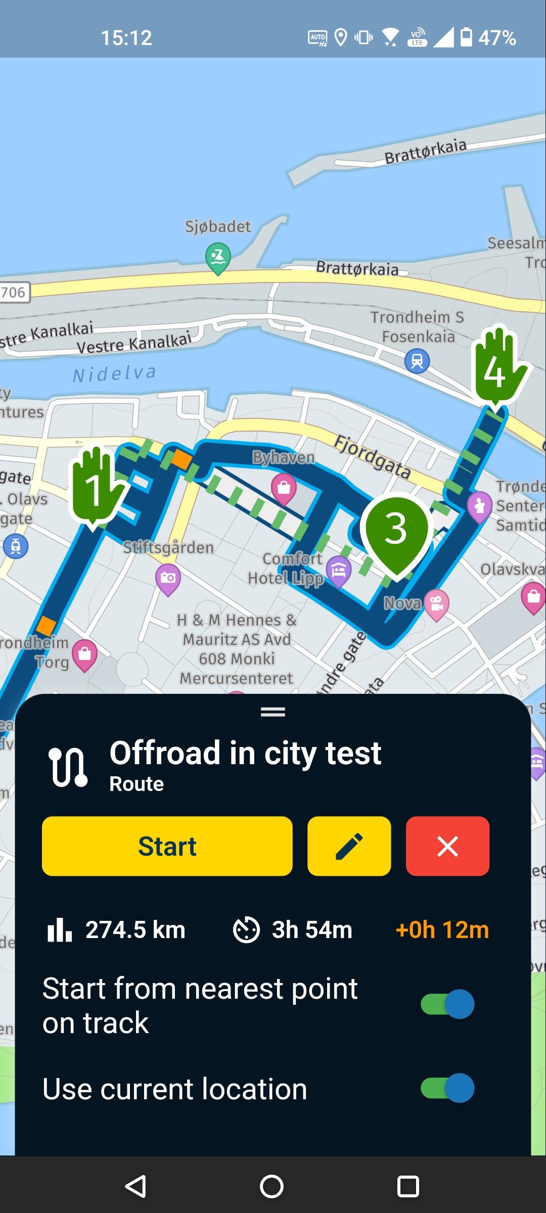
Offroad in city
-
Is there a way to stop MRA from calculating a route between off-road waypoints in cities?
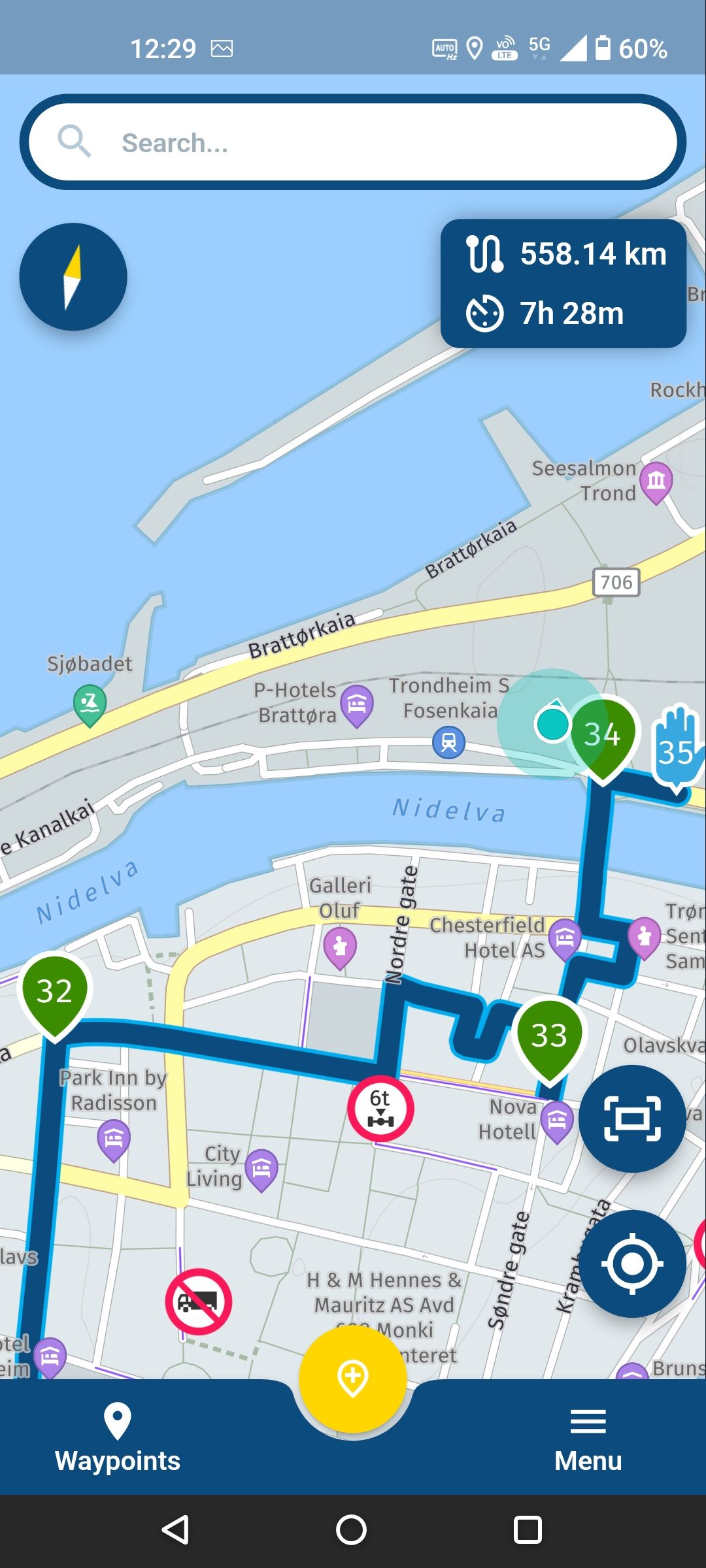
In the picture below I drive in a straight line from 32 to 33 and also from 33 to 34. I can because I drive the bus (normal cars are not allowed). I was hoping I could stop the app from being smart by defining off-road points but no.
-
Is there a way to stop MRA from calculating a route between off-road waypoints in cities?
In the picture below I drive in a straight line from 32 to 33 and also from 33 to 34. I can because I drive the bus (normal cars are not allowed). I was hoping I could stop the app from being smart by defining off-road points but no.
@Herman-Veldhuizen Can somebody confirm that Offroad only works in the web based route planner? As soon as I open the route in the app the app tries to place the route between off-road points on (nearby) roads. There is probably a technical reason for this but it would be nice to be consistent.
-
@Herman-Veldhuizen Can somebody confirm that Offroad only works in the web based route planner? As soon as I open the route in the app the app tries to place the route between off-road points on (nearby) roads. There is probably a technical reason for this but it would be nice to be consistent.
@Herman-Veldhuizen you can use the skip function in the planner and then you'll be on your own when you do that, exactly what you want I think
Honda Goldwing GL1500,
Honda Silverwing GL 650
DMD2 T865X 8 inch Android tablet using MRA next for navigation
Garmin XT sold
Samsung S24FE mounted on a Quadlock and using Android Auto in my car -
@Herman-Veldhuizen you can use the skip function in the planner and then you'll be on your own when you do that, exactly what you want I think
@Marinus-van-Deudekom I have used the skip function (suv on a slope) for the green points above. It works as expected in the planner but not in the navigation app.
-
@Herman-Veldhuizen Can somebody confirm that Offroad only works in the web based route planner? As soon as I open the route in the app the app tries to place the route between off-road points on (nearby) roads. There is probably a technical reason for this but it would be nice to be consistent.
@Herman-Veldhuizen, The offroad function of the web-planner should work while navigating in "navigate route as track" mode. I believe we have mentioned that mode to you in an earlier post, right? It has one backdraw though: it will ruin your ETA because the time for a "directline" as not added to the ETA. Iirc that was also important for you?
I am just an enthusiastic MRA user, and hope you will be one too!
Most motorcycle problems are caused by the nut that connects the handlebar to the saddle.
Check out RideSleepRepeat.eu, a biker community for sharing stays across Europe
-
@Herman-Veldhuizen, The offroad function of the web-planner should work while navigating in "navigate route as track" mode. I believe we have mentioned that mode to you in an earlier post, right? It has one backdraw though: it will ruin your ETA because the time for a "directline" as not added to the ETA. Iirc that was also important for you?
@Con-Hennekens I am navigating as track.
Yes I understand that it will ruin my ETA box but that's for another topic later. For now I only want to use the skip feature to explain to a colleague how I drive in some areas. These areas are small compared to the total distance and have no big effect on the ETA,s.
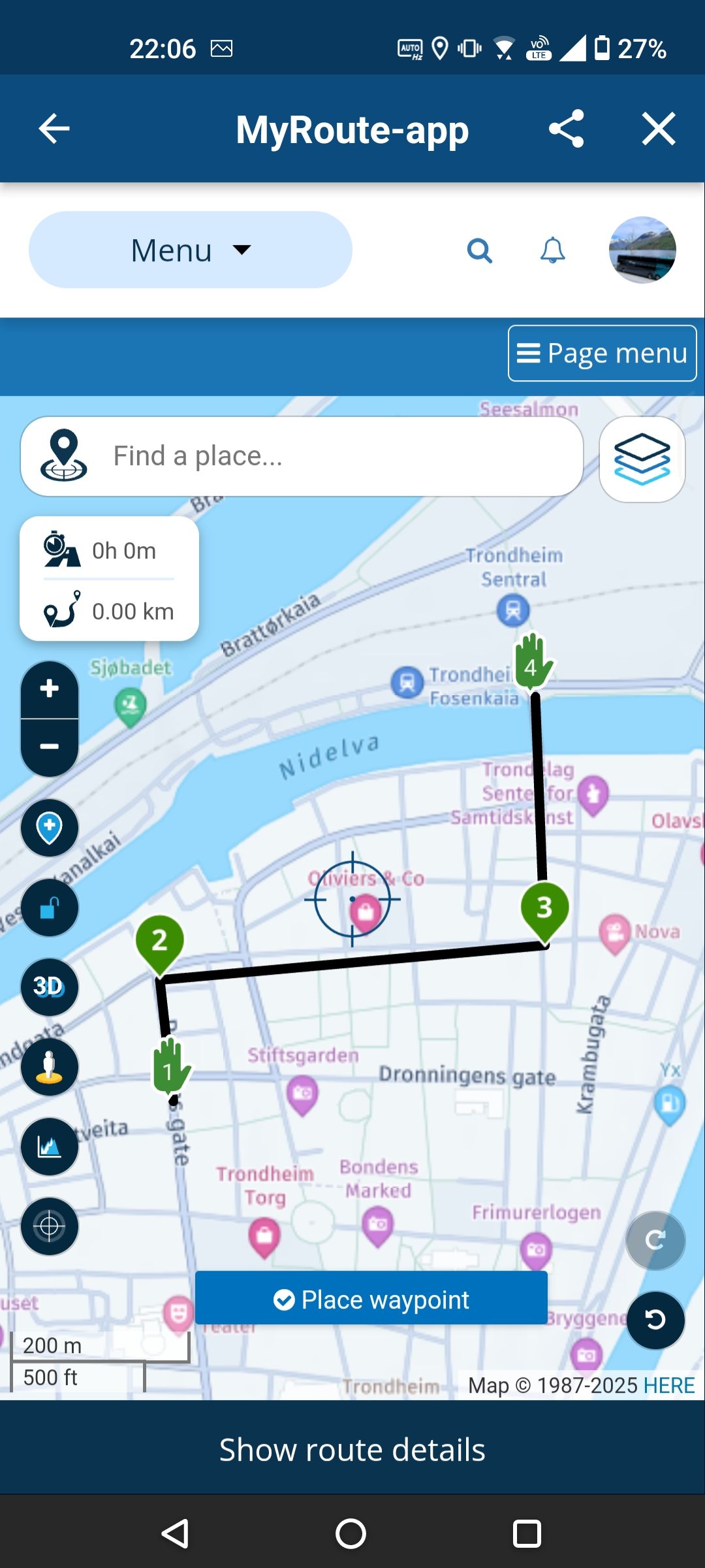
If you want to see the points, have a look here. The off-road points are the last few points.
https://www.myrouteapp.com/route/open/10542644 -
@Con-Hennekens I am navigating as track.
Yes I understand that it will ruin my ETA box but that's for another topic later. For now I only want to use the skip feature to explain to a colleague how I drive in some areas. These areas are small compared to the total distance and have no big effect on the ETA,s.
If you want to see the points, have a look here. The off-road points are the last few points.
https://www.myrouteapp.com/route/open/10542644@Herman-Veldhuizen Hi Herman
You've placed most of the routepoint OFF the actual roads.
I saw that you've used the OSM layer in the Here map, probably to get the busstations on the map.
The only routepoint ON the road are the green ones on witch you"ve used the skip button to force the system to take a direct road to the other side. In thoise case there are roads (closed for al other trafic beside busses)
Have you tried the ut the routepoint ON the road and use POI for the stations. What happens when you do that.
what you try to do in my opinion is out of the scope of MRAHonda Goldwing GL1500,
Honda Silverwing GL 650
DMD2 T865X 8 inch Android tablet using MRA next for navigation
Garmin XT sold
Samsung S24FE mounted on a Quadlock and using Android Auto in my car -
@Herman-Veldhuizen Hi Herman
You've placed most of the routepoint OFF the actual roads.
I saw that you've used the OSM layer in the Here map, probably to get the busstations on the map.
The only routepoint ON the road are the green ones on witch you"ve used the skip button to force the system to take a direct road to the other side. In thoise case there are roads (closed for al other trafic beside busses)
Have you tried the ut the routepoint ON the road and use POI for the stations. What happens when you do that.
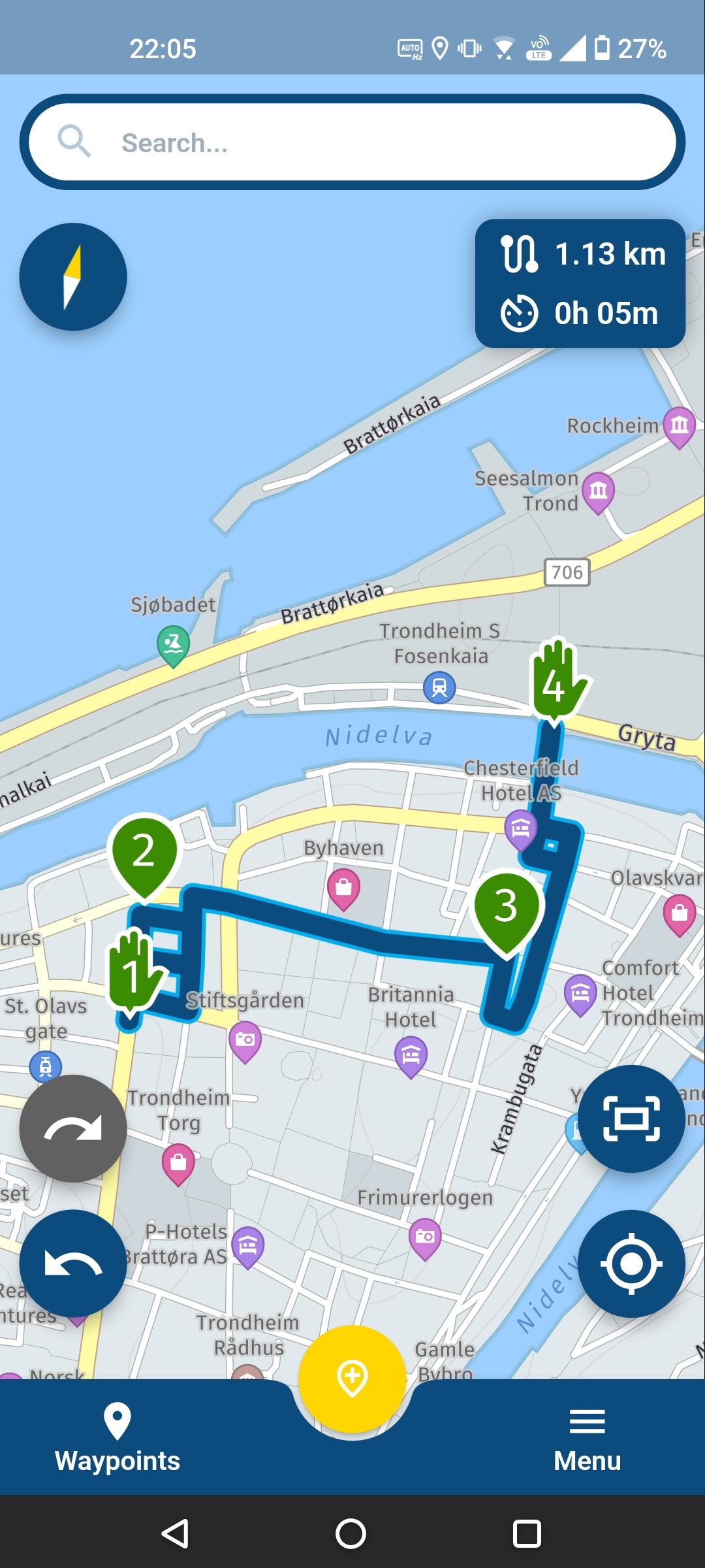
what you try to do in my opinion is out of the scope of MRA@Marinus-van-Deudekom Also when all points are on roads, the planner and app work differently. This is what I see also with another small test route. The planner creates straight lines between the (off-road) points, the app tries to place the lines on roads. Would be nice to know how to make them behave the same.
Using bus stops as waypoints is another topic. It currently has to be this way and it works quite well most of the time. -
@Marinus-van-Deudekom Also when all points are on roads, the planner and app work differently. This is what I see also with another small test route. The planner creates straight lines between the (off-road) points, the app tries to place the lines on roads. Would be nice to know how to make them behave the same.
Using bus stops as waypoints is another topic. It currently has to be this way and it works quite well most of the time. -
@Herman-Veldhuizen, The strange thing is that in my work area I am perfectly able to take a shortcut over a footpath where it is not allowed to drive a car/motorbike... Something stranhe happens though when I disable "Use current location":
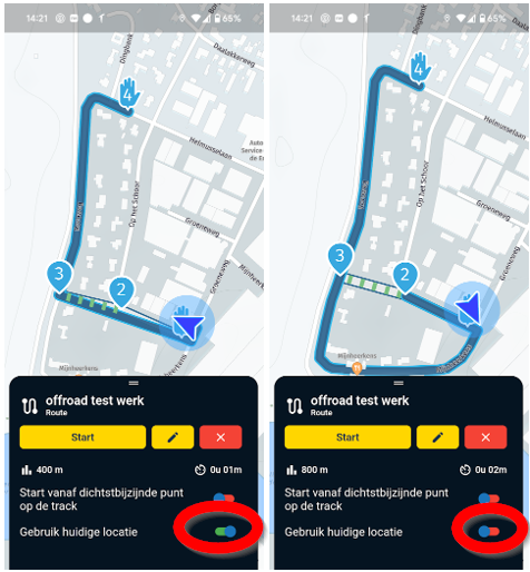
It still takes the offroad path but adds a loop somehow. I think for what you want to accomplish, you would need special maps that designate bus-lanes and a public transport profile.
I am just an enthusiastic MRA user, and hope you will be one too!
Most motorcycle problems are caused by the nut that connects the handlebar to the saddle.
Check out RideSleepRepeat.eu, a biker community for sharing stays across Europe
-
@Herman-Veldhuizen, The strange thing is that in my work area I am perfectly able to take a shortcut over a footpath where it is not allowed to drive a car/motorbike... Something stranhe happens though when I disable "Use current location":
It still takes the offroad path but adds a loop somehow. I think for what you want to accomplish, you would need special maps that designate bus-lanes and a public transport profile.
@Con-Hennekens A bus mode would be great but I am not holding my breath on that one. I was hoping that Skip would mean Skip, nomatter where the point is.
I now tried Navigate myself (for the first time) on my test route and I also see something interesting. The straight line path suddenly becomes visible. The only line I was hoping to see straight away.
What you are seeing is maybe the effect of limited gps accuracy ? Because the initial direction is in the opposite way in your 2nd picture. I described this problem in another post (named definition of nearest point).
https://forum.myrouteapp.com/post/58688 -
Skipping is really intended in areas where there are no roads / you are offroad.
I understand what you are trying to achieve but it’s not designed for this.
Hello! It looks like you're interested in this conversation, but you don't have an account yet.
Getting fed up of having to scroll through the same posts each visit? When you register for an account, you'll always come back to exactly where you were before, and choose to be notified of new replies (either via email, or push notification). You'll also be able to save bookmarks and upvote posts to show your appreciation to other community members.
With your input, this post could be even better 💗
Register Login-
0431.1k
-
0768
-
06135
-
017321
-
010304
-
0333
-
06214