Route on Temporary Road Closure?
-
I'm planning a route for middle March, and a portion of the National Trails Hwy is currently closed but expected to reopen. However, the Routeplanner is not allowing to route on the currently closed portion. Is there a way around this to ensure the route follows the road?
2009 BMW K1300GT
Garmin zümo XT
Samsung Galaxy Tab Active 5 w/RAM mount
2023 BMW R18 Transcontinental
iPhone 14 Pro Max w/QuadLock mount
Apple CarPlay in Carpuride W603D w/front-rear cameras -
I'm planning a route for middle March, and a portion of the National Trails Hwy is currently closed but expected to reopen. However, the Routeplanner is not allowing to route on the currently closed portion. Is there a way around this to ensure the route follows the road?
@Ron-Z If you use The HERE planning map you can use the tool: Disable seasonal closures from the toolkit.
Always willing to help if I can.
Triumph Tiger 1200 XRT called Tina.
MRA Navigation Next and SilverFox BJ8 -
@Ron-Z If you use The HERE planning map you can use the tool: Disable seasonal closures from the toolkit.
@Nick-Carthew said in Route on Temporary Road Closure?:
@Ron-Z If you use The HERE planning map you can use the tool: Disable seasonal closures from the toolkit.
I tried that, and it's not working.
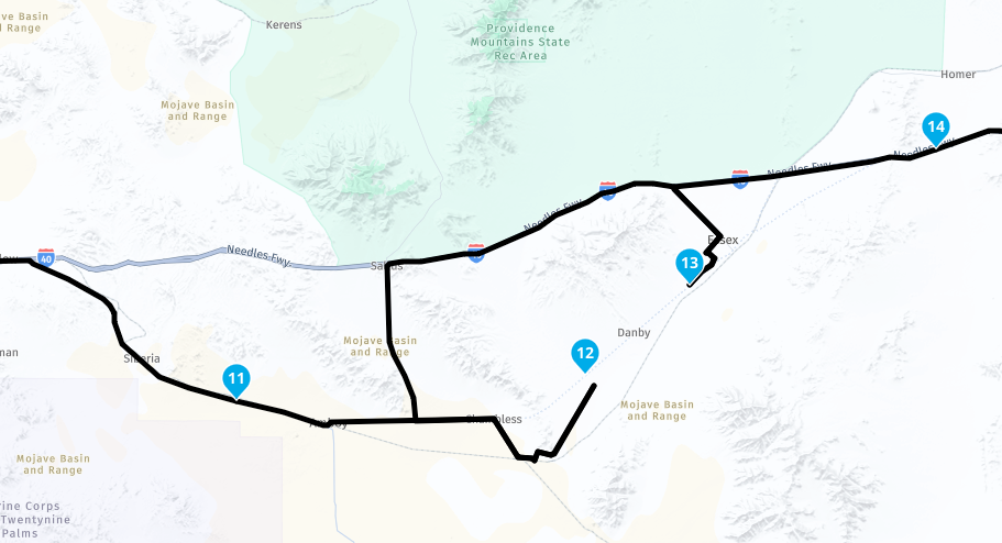
As you can see in the above image, the route is not continuous from points 12 to 13 and it's still routing me to avoid that. But the closure isn't seasonal, it's just closed due to some road damage that's expected to be repaired next month.
2009 BMW K1300GT
Garmin zümo XT
Samsung Galaxy Tab Active 5 w/RAM mount
2023 BMW R18 Transcontinental
iPhone 14 Pro Max w/QuadLock mount
Apple CarPlay in Carpuride W603D w/front-rear cameras -
@Nick-Carthew said in Route on Temporary Road Closure?:
@Ron-Z If you use The HERE planning map you can use the tool: Disable seasonal closures from the toolkit.
I tried that, and it's not working.
As you can see in the above image, the route is not continuous from points 12 to 13 and it's still routing me to avoid that. But the closure isn't seasonal, it's just closed due to some road damage that's expected to be repaired next month.
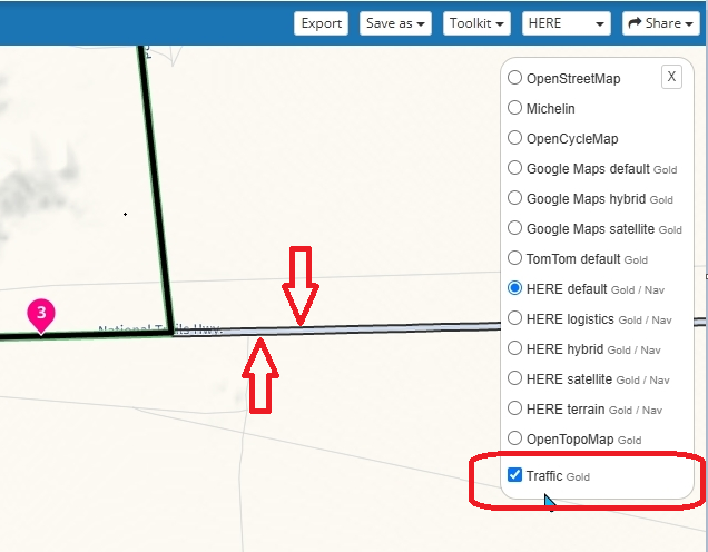
Put on the traffic layer and when there are black lines then is it reported as a close road
Garmin Zumo XT3/XT2/XT/BMW Connected Ride Navigator/Tourstart/ MyRouteapp (The App)/...
Een dag niet gelachen is een dag niet geleefd / Een route is net zo goed als deze uitgezet is. -
@Nick-Carthew said in Route on Temporary Road Closure?:
@Ron-Z If you use The HERE planning map you can use the tool: Disable seasonal closures from the toolkit.
I tried that, and it's not working.
As you can see in the above image, the route is not continuous from points 12 to 13 and it's still routing me to avoid that. But the closure isn't seasonal, it's just closed due to some road damage that's expected to be repaired next month.
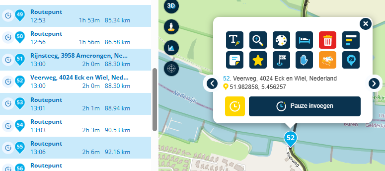
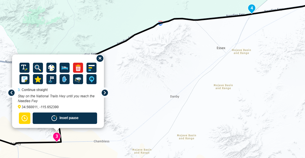
@Ron-Z If you know the road will be repaired by the time that you want to use it, then you do not need to do anything. I would maybe position a pink route point with information at Kelbaker Rd.
-
Put on the traffic layer and when there are black lines then is it reported as a close road
@Hans-van-de-Ven-MR-MRA said in Route on Temporary Road Closure?:
Put on the traffic layer and when there are black lines then is it reported as a close road
How do you "put on the traffic layer" ?
-
@Nick-Carthew said in Route on Temporary Road Closure?:
@Ron-Z If you use The HERE planning map you can use the tool: Disable seasonal closures from the toolkit.
I tried that, and it's not working.
As you can see in the above image, the route is not continuous from points 12 to 13 and it's still routing me to avoid that. But the closure isn't seasonal, it's just closed due to some road damage that's expected to be repaired next month.
@Ron-Z I have had this happen to me a few times with similar road closures in Wales. I generally will make sure that my shaping points will take me to the road (which I think they do from your picture). With the last point before the route, I will make pink with a warning icon and put a note in the waypoint about when the road is expected to open. Additionally at a point just before the detour for the closure, I will also put another point with a warning icon and call it 'Check Road Open' or something similar and I will then receive a verbal warning (settings dependent). The main point is that if you are navigating as a route then the navigation will take you on the route if the road is open when you start the route on your device and the route calculation is performed. Sometimes the roads are not always notified as being formally open but the check point allows me to see what signage is out if the route is open or not.
If you are navigating as route to track then same calculation should happen to generate the track correctly if the road is open. Happy to be corrected if not the case as I am still 'playing' with this new feature. The additional points I suggested will still be useful to check as with a route.
Remember that the web planning tool is just a planner based on published information (visible when selecting traffic) but your device will calculate your route or track on known information at that time when you start the app to navigate. Hope this makes sense and helpful.
-
@Hans-van-de-Ven-MR-MRA said in Route on Temporary Road Closure?:
Put on the traffic layer and when there are black lines then is it reported as a close road
How do you "put on the traffic layer" ?
@richard-3v said in Route on Temporary Road Closure?:
@Hans-van-de-Ven-MR-MRA said in Route on Temporary Road Closure?:
Put on the traffic layer and when there are black lines then is it reported as a close road
How do you "put on the traffic layer" ?
The last option in the overlay maps. A black line indicates a closure in one direction a black line on both sides indicates a full closure.
-
@Ron-Z
To plan a route to be travelled later, you can switch to the OSM Routing Engine(!), which will work.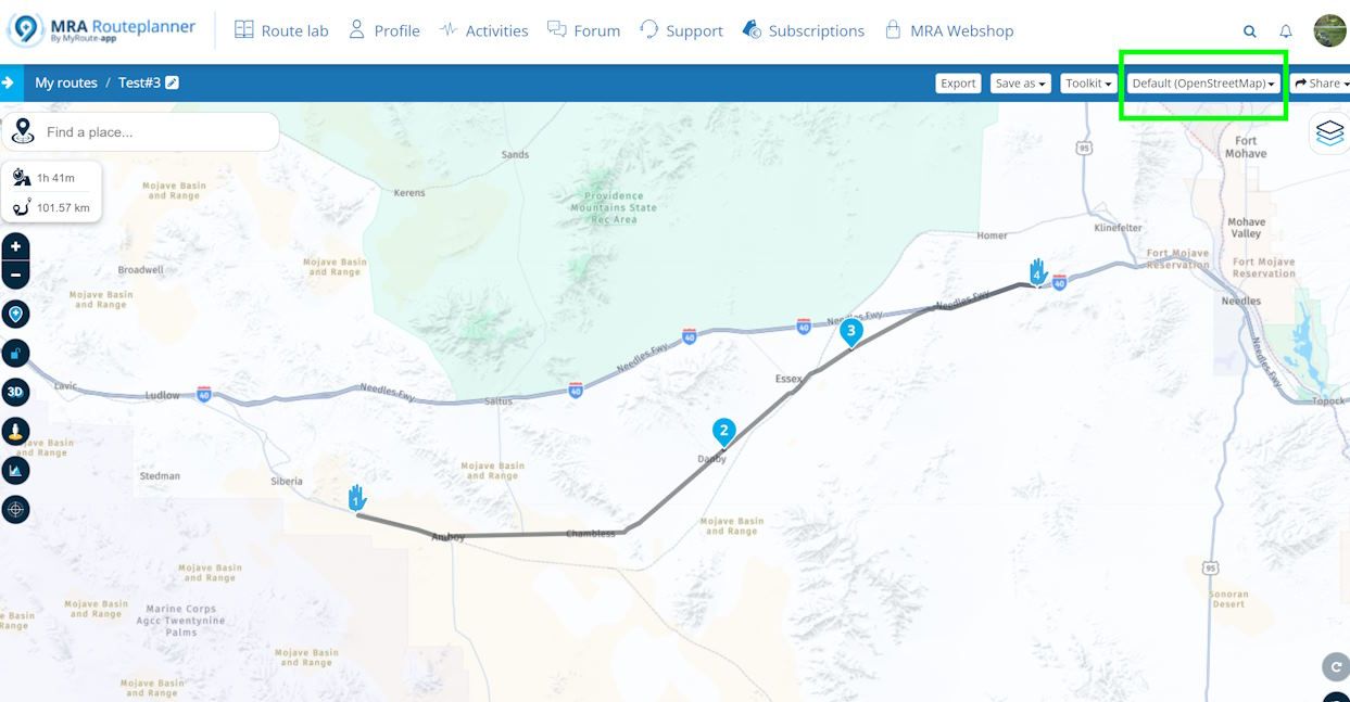 , which will work.
 -
@Nick-Carthew said in Route on Temporary Road Closure?:
@Ron-Z If you use The HERE planning map you can use the tool: Disable seasonal closures from the toolkit.
I tried that, and it's not working.
As you can see in the above image, the route is not continuous from points 12 to 13 and it's still routing me to avoid that. But the closure isn't seasonal, it's just closed due to some road damage that's expected to be repaired next month.
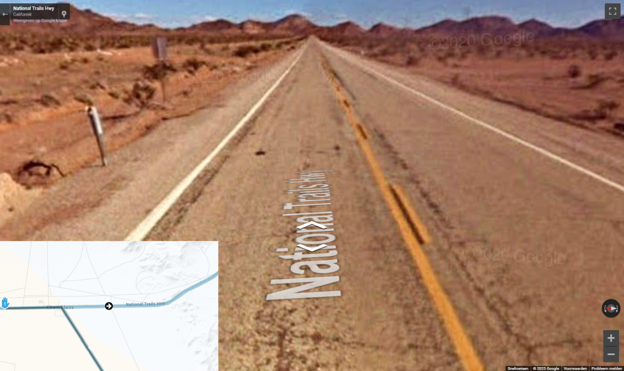
@Ron-Z, that road is depicted as a dotted line, which indicates an unpaved road. StreetView proves it is paved though, although it seems to be in a deplorable state...
https://mapfeedback.here.com/
says indeed that this road is unpaved indeed.
You can create a report there, to have it changed.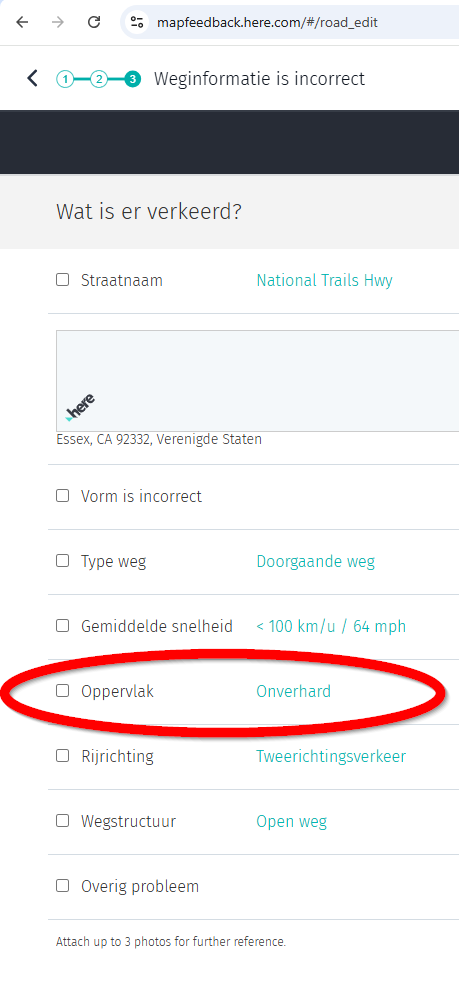
I am just an enthusiastic MRA user, and hope you will be one too!
Most motorcycle problems are caused by the nut that connects the handlebar to the saddle.
Check out RideSleepRepeat.eu, a biker community for sharing stays across Europe
-
@Ron-Z, that road is depicted as a dotted line, which indicates an unpaved road. StreetView proves it is paved though, although it seems to be in a deplorable state...
https://mapfeedback.here.com/
says indeed that this road is unpaved indeed.
You can create a report there, to have it changed.@Con-Hennekens said in Route on Temporary Road Closure?:
https://mapfeedback.here.com/
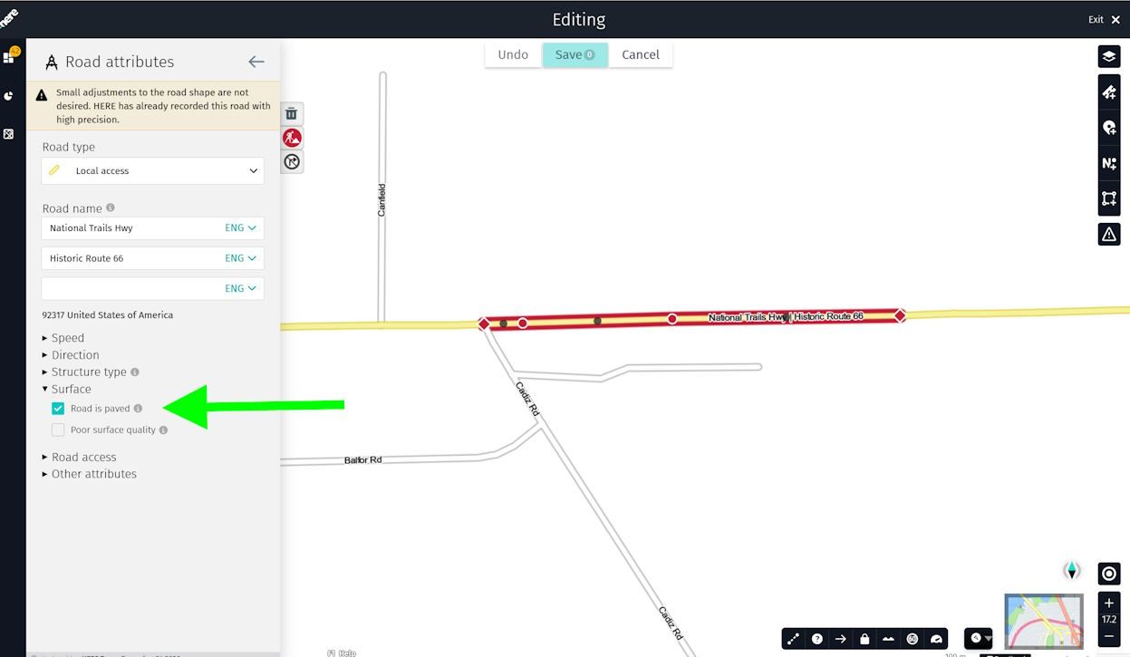
says indeed that this road is unpaved indeed.That's surprising - HERE Map Creator indicates the same section as paved...
-
Thank you

-
@Con-Hennekens said in Route on Temporary Road Closure?:
https://mapfeedback.here.com/
says indeed that this road is unpaved indeed.That's surprising - HERE Map Creator indicates the same section as paved...
@Martin-Wilcke said in Route on Temporary Road Closure?:
That's surprising - HERE Map Creator indicates the same section as paved...
Try a little bit further up the road to the east?
I am just an enthusiastic MRA user, and hope you will be one too!
Most motorcycle problems are caused by the nut that connects the handlebar to the saddle.
Check out RideSleepRepeat.eu, a biker community for sharing stays across Europe
-
@Martin-Wilcke said in Route on Temporary Road Closure?:
That's surprising - HERE Map Creator indicates the same section as paved...
Try a little bit further up the road to the east?
@Con-Hennekens said in Route on Temporary Road Closure?:
Try a little bit further up the road to the east?
hmmm... I checked "National Trails Hwy" from Amboy eastbound up to intersection Hwy I40 - all paved.
-
@Con-Hennekens said in Route on Temporary Road Closure?:
Try a little bit further up the road to the east?
hmmm... I checked "National Trails Hwy" from Amboy eastbound up to intersection Hwy I40 - all paved.
@Martin-Wilcke, No idea... I found it surprising to see it designated as unpaved in the first place too
")
Hello! It looks like you're interested in this conversation, but you don't have an account yet.
Getting fed up of having to scroll through the same posts each visit? When you register for an account, you'll always come back to exactly where you were before, and choose to be notified of new replies (either via email, or push notification). You'll also be able to save bookmarks and upvote posts to show your appreciation to other community members.
With your input, this post could be even better 💗
Register Login-
0684
-
0592
-
09139
-
012257
-
05114
-
1413229
-
0390
-
0333