Increase the number of exported GPX point
-
If the planned route is long, approx. more than 1,000 km, the number of exported GPX points does not allow an easy way to follow the track.
Is it possible to increase the number of exported points or to set a maximum distance between them?As an example, in the figure below are shown the exported GPX points:
@lpagani You can use 200 waypoints in a route. Isn't that enough for 1000km? That means, in theory, a waypoint every 5km. Often, you need far fewer than that. Or am I misunderstanding your question?
🏍️ BMW K1600GT-P (2013) | Nolan N100-5 with Sena 30K
📱 iOS on iPhone 13 & 16 (mounted on Quadlock or AliExpress extention on BMW-cradle)
🚙 Apple CarPlay in VW T-Roc
💻 Routelab on MacBook Air & iMac (Tahoe & Ventura) -
@lpagani You can use 200 waypoints in a route. Isn't that enough for 1000km? That means, in theory, a waypoint every 5km. Often, you need far fewer than that. Or am I misunderstanding your question?
@Rob-Verhoeff I mean the raw points exported in the track of GPX file, not the waypoints.
-
If the planned route is long, approx. more than 1,000 km, the number of exported GPX points does not allow an easy way to follow the track.
Is it possible to increase the number of exported points or to set a maximum distance between them?As an example, in the figure below are shown the exported GPX points:
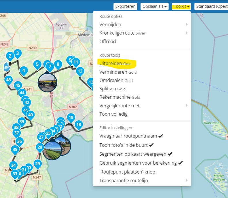
@lpagani in the toolkit there is an option (for gold members) to increase and decrease, or do you want something else?
-
@Rob-Verhoeff I mean the raw points exported in the track of GPX file, not the waypoints.
@lpagani Do you mean the number of viapoints from MRA that you export? Most devices have a limit on the number of viapoints (the hand symbol) you can include in a route. This varies from device to device.
-
@Rob-Verhoeff I mean the raw points exported in the track of GPX file, not the waypoints.
@lpagani as far as I know there is no way to tell MRA to include more navigation points in a track GPX file. It's my understanding that a track file already contains a huge number of navigation points . Converting a track to a route certainly results in a very large number of waypoints.
-
Thanks to all for your answers. To clarify I'm referring to the track points (the field
trkptin the GPX file), not the route (or shaping or via points).
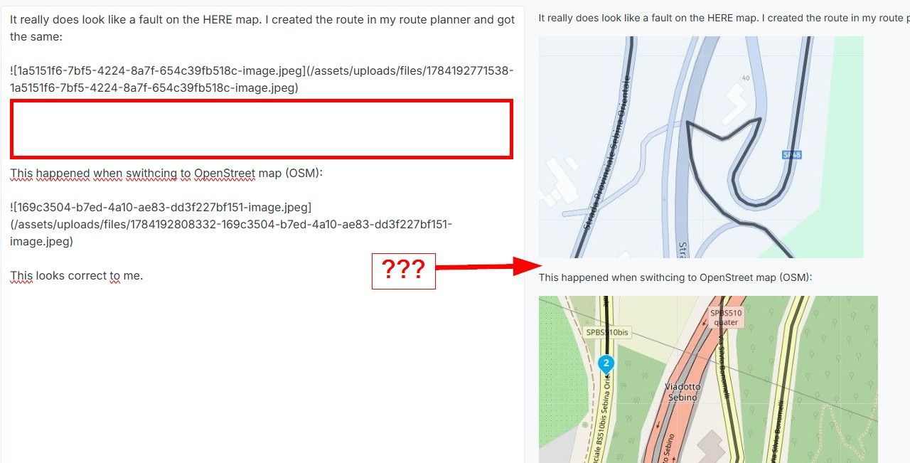
Currently I'm creating the route with MRA, export the GPX file and follow the track on OsmAnd, without the navigation function.To show what I mean I've exported the GPX of the track with a long route, ~3,000 km (red polyline), and a very short one (black polyline) and I imported both in MRA tracklog.
Comparing the two files, the red curve has less track points compared to the black one in the same portion of the route (I assume a decimation is done before exporting the file):
Since I don't use any active navigation following the track is very difficult in cities.
There is a limit of 30,000 points during a GPX import due to uploading performance reason.
I am wondering if there is the same limitation during the export and if there is a way to avoid it. 30,000 points seem a small number of points to accurately represent a long route. -
Thanks to all for your answers. To clarify I'm referring to the track points (the field
trkptin the GPX file), not the route (or shaping or via points).
Currently I'm creating the route with MRA, export the GPX file and follow the track on OsmAnd, without the navigation function.To show what I mean I've exported the GPX of the track with a long route, ~3,000 km (red polyline), and a very short one (black polyline) and I imported both in MRA tracklog.
Comparing the two files, the red curve has less track points compared to the black one in the same portion of the route (I assume a decimation is done before exporting the file):
Since I don't use any active navigation following the track is very difficult in cities.
There is a limit of 30,000 points during a GPX import due to uploading performance reason.
I am wondering if there is the same limitation during the export and if there is a way to avoid it. 30,000 points seem a small number of points to accurately represent a long route.@lpagani Then I must admit I don't know the answer...
-
If the planned route is long, approx. more than 1,000 km, the number of exported GPX points does not allow an easy way to follow the track.
Is it possible to increase the number of exported points or to set a maximum distance between them?As an example, in the figure below are shown the exported GPX points:
@lpagani You show us a map with the Track shown on it That is not a route and you will not receive instructions. You just have to follow the line manually.
If you would convert the track to a Route it will use the map to make sure you are using/following roads.The track is normally just a transfer method from one device to another. (Assuming you are not riding offroad).
-
@lpagani You show us a map with the Track shown on it That is not a route and you will not receive instructions. You just have to follow the line manually.
If you would convert the track to a Route it will use the map to make sure you are using/following roads.The track is normally just a transfer method from one device to another. (Assuming you are not riding offroad).
@Gerard-Wullink I prefer to follow the track instead of using the navigation although I'm not driving off-road. The track comes from a route planned in MRA, my goal is not to convert the track after exporting it or receive instructions.
My question was if it is possible to export the GPX with more track points, because the default number of points is pretty small if the planned route in MRA is long.
I've showed the image to show the low resolution of track points in the exported GPX file and the difference between a short and a long route.
-
@Gerard-Wullink I prefer to follow the track instead of using the navigation although I'm not driving off-road. The track comes from a route planned in MRA, my goal is not to convert the track after exporting it or receive instructions.
My question was if it is possible to export the GPX with more track points, because the default number of points is pretty small if the planned route in MRA is long.
I've showed the image to show the low resolution of track points in the exported GPX file and the difference between a short and a long route.
@lpagani No there is no way to set the number of points to export.
-
@Gerard-Wullink I prefer to follow the track instead of using the navigation although I'm not driving off-road. The track comes from a route planned in MRA, my goal is not to convert the track after exporting it or receive instructions.
My question was if it is possible to export the GPX with more track points, because the default number of points is pretty small if the planned route in MRA is long.
I've showed the image to show the low resolution of track points in the exported GPX file and the difference between a short and a long route.
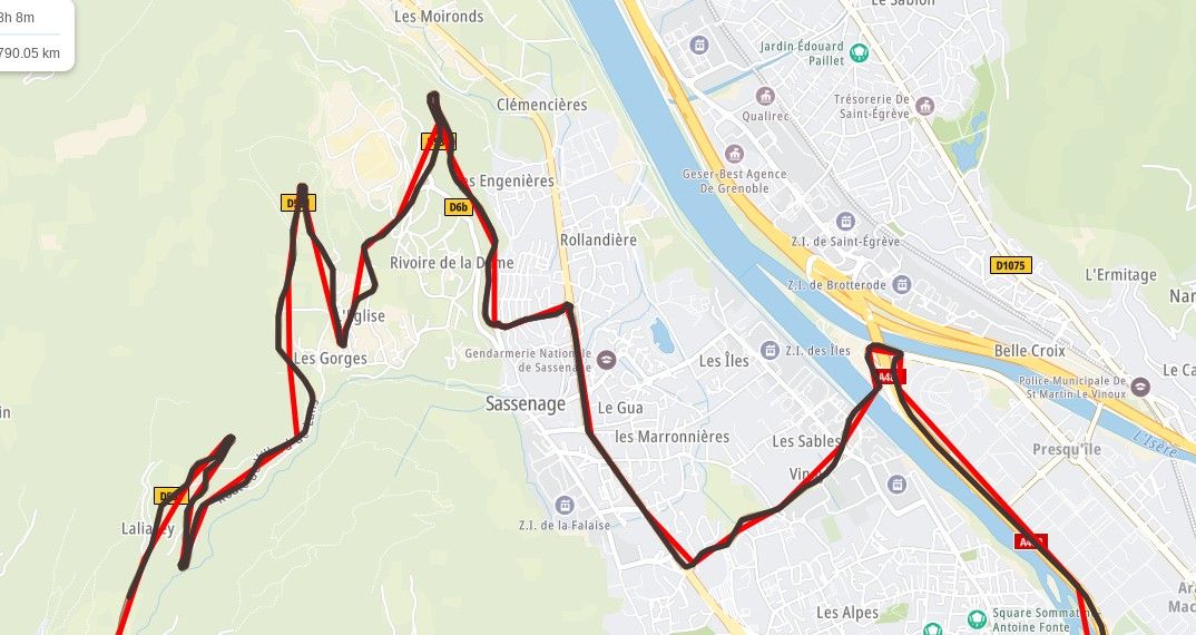
@lpagani That looks awfully familiar to the routes exported to the Garmin devices. Straight lines between the via points.
-
@lpagani That looks awfully familiar to the routes exported to the Garmin devices. Straight lines between the via points.
@UltraStar a track has straight lines between points. only it has many points so when you zoom out ik looks like it follows a road or a path. a track has no connection with a map but is just a list op point with there position.
-
@UltraStar a track has straight lines between points. only it has many points so when you zoom out ik looks like it follows a road or a path. a track has no connection with a map but is just a list op point with there position.
@Bouke-Ent Thank you, I do understand that. Still, the red line (short track outlined by @Ipagani) looks like the route exported to Garmin. There were lot of posts in the past about that and, I am guessing, that issue was resolved.
Considering point limit during the GPX import, I can understand longer straight lines.
I use MyRoute-app exclusively so I am not an expert in exporting the file. I had Zumo before, and it was too much hassle to transfer, convert, fix the straight lines. I just want to ride. -
Thanks to all for your answers. To clarify I'm referring to the track points (the field
trkptin the GPX file), not the route (or shaping or via points).
Currently I'm creating the route with MRA, export the GPX file and follow the track on OsmAnd, without the navigation function.To show what I mean I've exported the GPX of the track with a long route, ~3,000 km (red polyline), and a very short one (black polyline) and I imported both in MRA tracklog.
Comparing the two files, the red curve has less track points compared to the black one in the same portion of the route (I assume a decimation is done before exporting the file):
Since I don't use any active navigation following the track is very difficult in cities.
There is a limit of 30,000 points during a GPX import due to uploading performance reason.
I am wondering if there is the same limitation during the export and if there is a way to avoid it. 30,000 points seem a small number of points to accurately represent a long route.Hi @lpagani
Since I don't use any active navigation following the track is very difficult in cities.
Sorry I don't have an ideal solution
From your above posts it seems you dont want to use a route or any active navigation intructions, could you advise why you prefer to manually follow the track & not a route?Reason I ask is in Osmand you can take a track & use the "Attach to Roads" feature which will do a similar thing as adding more track points. i.e. it will force the path onto the nearest roads
The issue may be for you that this produces a route but you could just follow the route line if you dont start the active navigation which would be similar to following the track lineBlackView BV7100, Android 12
Navigate "Routes as Tracks" in Offline mode with Offline Maps
No Wifi, no internet, no interruptions, works well -
Hi @lpagani
Since I don't use any active navigation following the track is very difficult in cities.
Sorry I don't have an ideal solution
From your above posts it seems you dont want to use a route or any active navigation intructions, could you advise why you prefer to manually follow the track & not a route?Reason I ask is in Osmand you can take a track & use the "Attach to Roads" feature which will do a similar thing as adding more track points. i.e. it will force the path onto the nearest roads
The issue may be for you that this produces a route but you could just follow the route line if you dont start the active navigation which would be similar to following the track line@Brian-McG no problem, thanks for the answer anyway. I don't have any practical reason to don't use active navigation, I'm just used to use the passive one while riding. It's a kind of mixture between the paper map and the active navigation.
Attaching the track the road and then create a route or a new track in OsmAnd is possible. This is what I do for short tracks, about two or three days. Unfortunately it doesn't work for long tracks (sometimes it cuts the track in half or it doesn't find a solution at all).
The workaround I found is to split the route in segment of approx 1,500 km, export them to TomTom planner, recreate the route and export the GPX that has way more points than the MRA exporter.
Hello! It looks like you're interested in this conversation, but you don't have an account yet.
Getting fed up of having to scroll through the same posts each visit? When you register for an account, you'll always come back to exactly where you were before, and choose to be notified of new replies (either via email, or push notification). You'll also be able to save bookmarks and upvote posts to show your appreciation to other community members.
With your input, this post could be even better 💗
Register Login-
618130
-
026535
-
06157
-
615121
-
0857
-
0369
-
04144
-
0493