FEATURE RELEASE: Height profile (available for everyone!)
-
Attention Community,
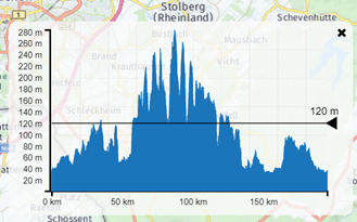
You can now view a height profile of your routes. Activating the height profile renders a 2D graphic of your route on the map, clearly showing what parts of the route go over higher terrain and which parts go through lower terrain.
Basic usage of the height profile
You activate the height profile on any route by clicking the height-profile button. Once active it’ll turn blue.(height profile inactive)

(height profile active)

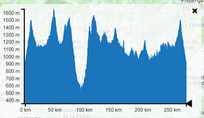
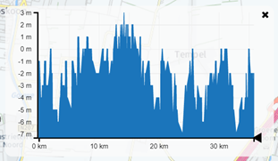
Once activated, the height profile graph is rendered in the lower right of your route. The graphic automatically picks a range of heights relative to your route on the y axis. This means that on roads with less height-difference (such as roads in the Netherlands) will still show the relative height difference. However, in these cases it will be differences in a few meters, rather than hundreds of meters.
(a route with high relative height-difference shows clear peaks and valleys)
(a route with low relative height difference shows slight differences in elevation)
Advanced usage: height reviewing
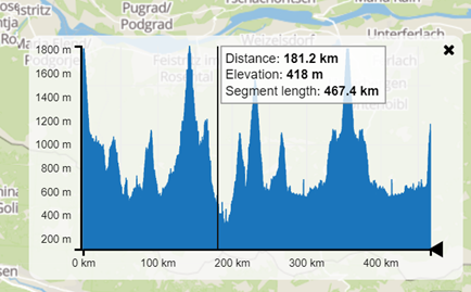
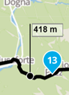
The graph allows users to review the height profile of their route by intelligently tracking the connection between a point on the graph and the corresponding coordinate on your route. For this purpose we use height-flags. If you move your mouse over the graph, a flag containing the details of the corresponding coordinate will show. Additionally, you’ll see a smaller flag appear on your route indicating the exact location coordinate. Clicking the coordinate in the graph will zoom in on the map.(a flag with details will appear when you mouse-over in the graph)
(a flag will apear over the corresponding location on the map)
Advanced usage: threshold reviewing
The graph has a handy threshold slider allowing you to slice off parts of the route above or below the threshold slider. The threshold slider is located in the bottom right corner of the height profile graph. To move the treshold up, click and hold the black triangle. Whilst holding the black triangle, move the mouse up vertically. Release the handle at an elevation of your choice.(default position of the threshold slider handle)

(after moving the threshold slider, it will remain on it’s position of release, clearly slicing the height profile).
After releasing the handle, the graph becomes clearly sliced at the set elevation. Using the threshold slider as a visual guide you can verify that parts of the route are indeed all above or below a certain elevation.
We look forward to hearing your thoughts on this new feature. And as with anything, feel free to leave a comment.
-
Attention Community,
You can now view a height profile of your routes. Activating the height profile renders a 2D graphic of your route on the map, clearly showing what parts of the route go over higher terrain and which parts go through lower terrain.
Basic usage of the height profile
You activate the height profile on any route by clicking the height-profile button. Once active it’ll turn blue.(height profile inactive)
(height profile active)
Once activated, the height profile graph is rendered in the lower right of your route. The graphic automatically picks a range of heights relative to your route on the y axis. This means that on roads with less height-difference (such as roads in the Netherlands) will still show the relative height difference. However, in these cases it will be differences in a few meters, rather than hundreds of meters.
(a route with high relative height-difference shows clear peaks and valleys)
(a route with low relative height difference shows slight differences in elevation)
Advanced usage: height reviewing
The graph allows users to review the height profile of their route by intelligently tracking the connection between a point on the graph and the corresponding coordinate on your route. For this purpose we use height-flags. If you move your mouse over the graph, a flag containing the details of the corresponding coordinate will show. Additionally, you’ll see a smaller flag appear on your route indicating the exact location coordinate. Clicking the coordinate in the graph will zoom in on the map.(a flag with details will appear when you mouse-over in the graph)
(a flag will apear over the corresponding location on the map)
Advanced usage: threshold reviewing
The graph has a handy threshold slider allowing you to slice off parts of the route above or below the threshold slider. The threshold slider is located in the bottom right corner of the height profile graph. To move the treshold up, click and hold the black triangle. Whilst holding the black triangle, move the mouse up vertically. Release the handle at an elevation of your choice.(default position of the threshold slider handle)
(after moving the threshold slider, it will remain on it’s position of release, clearly slicing the height profile).
After releasing the handle, the graph becomes clearly sliced at the set elevation. Using the threshold slider as a visual guide you can verify that parts of the route are indeed all above or below a certain elevation.
We look forward to hearing your thoughts on this new feature. And as with anything, feel free to leave a comment.
@Timo-Martosatiman-MRA Very nice feature!!! And fun to watch past "scary routes with this tool.
")
-
Attention Community,
You can now view a height profile of your routes. Activating the height profile renders a 2D graphic of your route on the map, clearly showing what parts of the route go over higher terrain and which parts go through lower terrain.
Basic usage of the height profile
You activate the height profile on any route by clicking the height-profile button. Once active it’ll turn blue.(height profile inactive)
(height profile active)
Once activated, the height profile graph is rendered in the lower right of your route. The graphic automatically picks a range of heights relative to your route on the y axis. This means that on roads with less height-difference (such as roads in the Netherlands) will still show the relative height difference. However, in these cases it will be differences in a few meters, rather than hundreds of meters.
(a route with high relative height-difference shows clear peaks and valleys)
(a route with low relative height difference shows slight differences in elevation)
Advanced usage: height reviewing
The graph allows users to review the height profile of their route by intelligently tracking the connection between a point on the graph and the corresponding coordinate on your route. For this purpose we use height-flags. If you move your mouse over the graph, a flag containing the details of the corresponding coordinate will show. Additionally, you’ll see a smaller flag appear on your route indicating the exact location coordinate. Clicking the coordinate in the graph will zoom in on the map.(a flag with details will appear when you mouse-over in the graph)
(a flag will apear over the corresponding location on the map)
Advanced usage: threshold reviewing
The graph has a handy threshold slider allowing you to slice off parts of the route above or below the threshold slider. The threshold slider is located in the bottom right corner of the height profile graph. To move the treshold up, click and hold the black triangle. Whilst holding the black triangle, move the mouse up vertically. Release the handle at an elevation of your choice.(default position of the threshold slider handle)
(after moving the threshold slider, it will remain on it’s position of release, clearly slicing the height profile).
After releasing the handle, the graph becomes clearly sliced at the set elevation. Using the threshold slider as a visual guide you can verify that parts of the route are indeed all above or below a certain elevation.
We look forward to hearing your thoughts on this new feature. And as with anything, feel free to leave a comment.
@Timo-Martosatiman-MRA Another great tool added to the toolkit

 Bravo
Bravo -
Great

-
Thank you all! I'll tell the team about the appreciation. More will follow soon!
-
Dat is geweldig mooi
-
Very nice feature. I like this very much!
-
Great addition to MRA. Is it possible to have a feature that would allow the user to switch from Meters to Feet. This would help some of us in the USA as we are not as familiar with the metric measurements used internationally. Thanks
-
And, as already suggested by me, have the ability to see estmated gardients at the intersection ot the vertical line, particulalry of interest for cyclists.
-
If there a way to display Height in feet?
-
Very cool feature as you can find the highest points on your route moving the slider up and down and it shows them on the map in red. we have one in our group that gets elevation sickness so we can avoid these areas in planning. Would love to have a setting to change into feet or meters. keep up the good work MR team!
-
@David-McCoy @TL-Donnelly @Scuba-Steve
Thank you for your suggestion. In close cooperation with one of our developers we've now added this feature to the height profile.
-
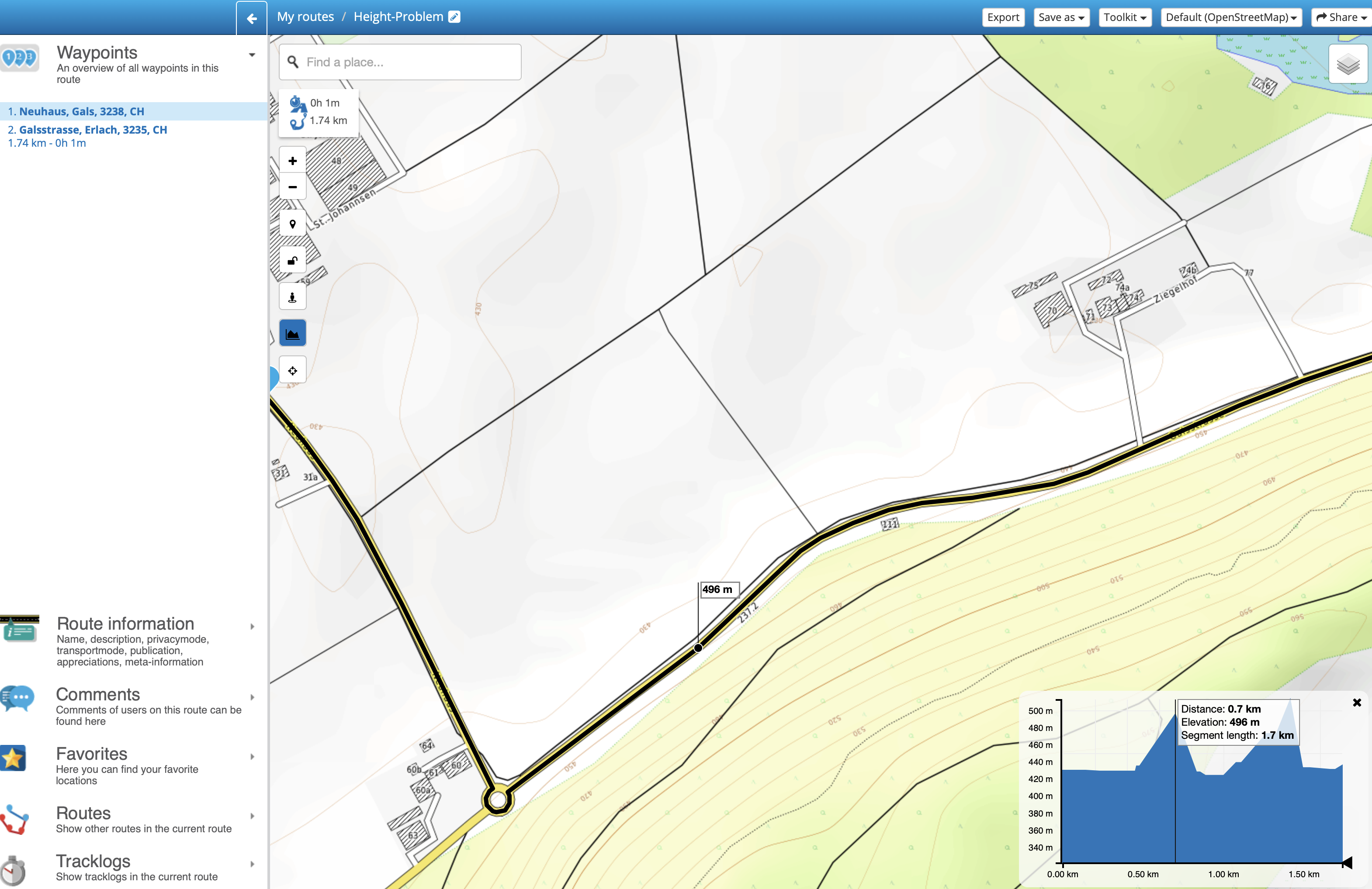
Very nice and wanted feature, thanks.
But I see some problems with the height. Two many non existant peaks of 10 to 90 meters on my tracks. For example on a flat road near my home 2 points very near show height of 429 meter and 20 meters further height of 496 meters. That's quite a difference, at least for a bicycle point of view.
Can this problem be avoided ? -
Hi Claude, I'm not perceiving these problems myself. However, I've listed the problem as a possible bug.
-
Hi Claude, I'm not perceiving these problems myself. However, I've listed the problem as a possible bug.
@Timo-Martosatiman-MRA
Hi Timo, thanks for your answer. To try to better show the problem I have created a short, flat road (altitude 430m) that runs along a hill. In the height profile some altitudes are not correct and make it look like there are 2 hills with altitude of about 500m on the route itself. I used the OpenTopoMap maps in this example because these maps clearly show the altitude lines and show that the route is really flat. Here is a link which shows a screen copy of the problem:
screencopy of the problem -
I'm really liking this feature - especially for cycling. The only thing I'd like to see added is a way to see the total elevation change of a route.
Hello! It looks like you're interested in this conversation, but you don't have an account yet.
Getting fed up of having to scroll through the same posts each visit? When you register for an account, you'll always come back to exactly where you were before, and choose to be notified of new replies (either via email, or push notification). You'll also be able to save bookmarks and upvote posts to show your appreciation to other community members.
With your input, this post could be even better 💗
Register Login-
0456.2k
-
0440
-
0411
-
315847
-
0121.5k
-
010229
-
021368
-
138111