The Great Suggestion List
-
Can I add a couple of other suggestions which I've previously raised on the "old" topics/forums
-
Add speed limit data for roads. This is already available and open source from OpenStreetMap data
-
Being able to change the colour and transparency of the route line (solid black isn't always the most helpful!)
-
-
Can I add a couple of other suggestions which I've previously raised on the "old" topics/forums
-
Add speed limit data for roads. This is already available and open source from OpenStreetMap data
-
Being able to change the colour and transparency of the route line (solid black isn't always the most helpful!)
@Will-Brooks Hi Will, you may definitely suggest those! However, please do so in seperate threads as that will allow discussion on those subjects to happen in a structured manner. If someone else raises a similar suggestion, I'll then forward them that specific thread. This is to avoid having a conversation about detail here in the comments on the suggestion list.
-
-
@Timo-Martosatiman-MRA please can you add this to "great suggestion list" :
At MRA Navigation App, especialy the only one used map is really a pain!
It is possible in MRA to create routes for driving, cycling, or by foot. And for this purpose you can use maps which fits best for: OpenCyleMap or OpenTopoMap (both as Gold Member). With this, you can use small paths or gravel roads to do route planning.But then, if you will use the route in MRA Navigation App, the App is only using HERE Map and will not show your route if ther is no big street! Ok, directing the driver by message is one thing - but simply showing current position on map and route is the other thing. Because this is essentially, it mußt be developed soon! Otherwise App is senseless for cyclists and pedestrians.
May do it for Gold Memers only - but do it. -
Hi, suggestions are made and i probalby inserted more suggestions which from my point of view make sense. However when looking at the releases for MyRouteApp-Navigation, the last release with new features was on October/19.
These are 6 months without any new functionality and no announcements only a suggestion list.
To get a better communication between the development team and the users it would be good to have more information about what is planned for the next release.
It would also be a good thing even for you to start a Beta program for your App where we can participate and give you immediately feedback. I know this is possible to with Android-Apps on Google Play.
What do you think MRA-Team? -
Hi, suggestions are made and i probalby inserted more suggestions which from my point of view make sense. However when looking at the releases for MyRouteApp-Navigation, the last release with new features was on October/19.
These are 6 months without any new functionality and no announcements only a suggestion list.
To get a better communication between the development team and the users it would be good to have more information about what is planned for the next release.
It would also be a good thing even for you to start a Beta program for your App where we can participate and give you immediately feedback. I know this is possible to with Android-Apps on Google Play.
What do you think MRA-Team?I am not part of the MRA team but to give them credit: it is not correct that there have been no announcements.
In fact, the big announcement was called MRA Video which was scheduled for release end last year (a bit too optimistic as it seems
 ) but is "upcoming.
Next to that some refactoring has been urgently done to go round some Google price hike, and there has been a substantial amount of bug fixing as well.
In addition, they invented recently the great suggestion list that several forum members have contributed to, and for which the voting (and decision) wil be finalized/has finalized? very soon. Involving users in a decision making process takes time, you need to collect the idea's, make a first list, have a first voting round to downsize that huge list, then a final vote to determine the next iteration of the software...
We just have to wait a few more days/weeks for the outcome of that final voting and have the first roadmap.
In any case: if you open a new post with title: "great suggestion list: topic title" and then some content explaining what you mean then you will undoubtedly get soem reaction from other users, and make it easy for MRA to find all suggestions.
-
Hi,
I would like to add a suggestion to impliment the "Offroad" functionality in MRA into the Navigation App
Using the "Offroad" functionality in MRA, it simply draws a straight line between the waypoints rather than plotting the route via actual roads.
This would allow actual plotting of the UK's Ordanance Survey "Green Lanes" or Byways Open to All Traffic which very often unclearly or incorrectly marked on the actual trail.For other countries where there are vast open spaces that can be legally ridden anywhere this would be great for those users as they could share there gnarliest (or not) trails with others.
Thanks.
Steve. -
@Timo-Martosatiman-MRA said in The Great Suggestion List:
Unlike the original Tyre a favorite cannot be left permanently showing on the general map template, presumably because each map generated in MRA is a stand alone item. A favorite can only be added as a waypoint, it would be a good feature if a favorite could be added permanently as is the case with POI's. To me there is a difference between a favorite and a POI, a favorite can be someone's address personal to you, a POI is more of a general interest. The difference in the visual image of the icons is the important significance.
-
Suggestion: add a "export as link to GPX".
Rationale: exporting through USB is so very 2005, but all currently available alternatives require the use of intermediate storage.
Current "export as a link" links to the interactive MRA webapp. While I understand the viral value this has for MRA (as a company), as a user I would like to be able to drop a link directly into other apps.
This is what URLs were invented for, right?
-
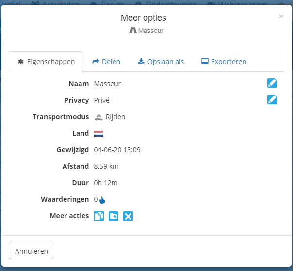
Suggestion: change the route-type of an existing or imported route.
When you start making a new route you have to choose what type this route is (Driving, Cycling, By foot). I use MRA for preparing running-routes as well and when you (accidentally) select a different type it is not possible to modify this later on.
This also goes when using imported Route-tracks: when choosing to use the track as a route you don't have the possibility to select what type of route it is.
-
Suggestion: change the route-type of an existing or imported route.
When you start making a new route you have to choose what type this route is (Driving, Cycling, By foot). I use MRA for preparing running-routes as well and when you (accidentally) select a different type it is not possible to modify this later on.
This also goes when using imported Route-tracks: when choosing to use the track as a route you don't have the possibility to select what type of route it is.
Hello BJ,
You can change this afterwards in the route-information
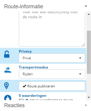
or via the 3 dots behind the route in your route library
-
Nice to find myself in the list
")
The actual suggestion was to "search routes based on X-distance form destantion an originating Y-distance from desired starting point" But I will forgive about the shortened versionMay I deposit another one here, for Navigation?
- Expand the on-screen information with current-time, direction or compass, Height, en maybe more. It could be placed on either side of a landscape navigation screen, since more map than really needed is shown when using landscape. Maybe even move speed etc to the same location.
And for MRA?
- Since we have the heightprofile information, it could be used for a "caravan & camper" function. As opposite to the curvy road functions, Caravan and Camper drivers could benefit from leaving out slopes beyond a certain parameter.
I am just an enthusiastic MRA user, and hope you will be one too!
Most motorcycle problems are caused by the nut that connects the handlebar to the saddle.
Check out RideSleepRepeat.eu, a biker community for sharing stays across Europe
-
Idea and suggestion from @Martin-Cooke: Is it possible to do a search in MRA by grid reference? A created waypoint's info contains the grid reference, surely that must be possible?
-
MRA Navigation Suggestion:
Add a button for change from "guidance view" (Standard MRA navigation view) to "map view" too see where i am in the track.
Alternatively a zoom +/- could be a good solution.Doing always a pinch-to-zoom is complicated. You have to stop the ride and take off the gloves.
-
Vandaag even wat routes 'geoptimaliseerd'. Twee dingen waar ik tegenaan liep. Ik moest een grote route met een stuk of 80 routepunten nalopen (puntjes op de weg zetten en niet op kruispunten bijvoorbeeld). Als je dan een routepunt aanklikt krijg je het popupje met de opties .
Nadat je het routepunt even iets verschoven hebt, herberekent MRA de route. Daarna is gelijk het popupje weg. Als je dus naar het volgende routepunt wilt klikken met de pijltjes, moet je eerst weer het routepunt aanklikken en dan pas op het pijltje. Als dat popupje nu niet verdwijnt, maar blijft staan gaat dat sneller (scheelt een klik) en scheelt ook de kans op een misklik (en dat er dan een routepunt wordt toegevoegd). Een optie om te kiezen voor het laten staan van het popupje zou wel een welkome aanvulling zijn.
Dit brengt me op het volgende punt. Als je misklikt en er een routepunt wordt toegevoegd, komt daar rechtsonder in je scherm een bevestiging van
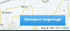
echter staat die bevestiging precies boven op de 'ongedaan maak button' (de oh-shit knop volgens Serge).
Is het een idee om die bevestiging linksonder in het scherm te plaatsen, daar staat ie niets in de weg. Dit maakt het corrigeren van een misklik sneller, want je hoeft niet 3 seconden te wachten met ongedaan maken.
Het zou in mijn ogen de gebruiksvriendelijkheid ten goede komen en lijken me beide geen hele zware aanpassingen.
-
Vandaag even wat routes 'geoptimaliseerd'. Twee dingen waar ik tegenaan liep. Ik moest een grote route met een stuk of 80 routepunten nalopen (puntjes op de weg zetten en niet op kruispunten bijvoorbeeld). Als je dan een routepunt aanklikt krijg je het popupje met de opties .
Nadat je het routepunt even iets verschoven hebt, herberekent MRA de route. Daarna is gelijk het popupje weg. Als je dus naar het volgende routepunt wilt klikken met de pijltjes, moet je eerst weer het routepunt aanklikken en dan pas op het pijltje. Als dat popupje nu niet verdwijnt, maar blijft staan gaat dat sneller (scheelt een klik) en scheelt ook de kans op een misklik (en dat er dan een routepunt wordt toegevoegd). Een optie om te kiezen voor het laten staan van het popupje zou wel een welkome aanvulling zijn.
Dit brengt me op het volgende punt. Als je misklikt en er een routepunt wordt toegevoegd, komt daar rechtsonder in je scherm een bevestiging van
echter staat die bevestiging precies boven op de 'ongedaan maak button' (de oh-shit knop volgens Serge).
Is het een idee om die bevestiging linksonder in het scherm te plaatsen, daar staat ie niets in de weg. Dit maakt het corrigeren van een misklik sneller, want je hoeft niet 3 seconden te wachten met ongedaan maken.
Het zou in mijn ogen de gebruiksvriendelijkheid ten goede komen en lijken me beide geen hele zware aanpassingen.
@Wytze Inderdaad kleinigheden maar lijken me wel belangrijk qua gebruiksvriendelijkheid
-
Vandaag even wat routes 'geoptimaliseerd'. Twee dingen waar ik tegenaan liep. Ik moest een grote route met een stuk of 80 routepunten nalopen (puntjes op de weg zetten en niet op kruispunten bijvoorbeeld). Als je dan een routepunt aanklikt krijg je het popupje met de opties .
Nadat je het routepunt even iets verschoven hebt, herberekent MRA de route. Daarna is gelijk het popupje weg. Als je dus naar het volgende routepunt wilt klikken met de pijltjes, moet je eerst weer het routepunt aanklikken en dan pas op het pijltje. Als dat popupje nu niet verdwijnt, maar blijft staan gaat dat sneller (scheelt een klik) en scheelt ook de kans op een misklik (en dat er dan een routepunt wordt toegevoegd). Een optie om te kiezen voor het laten staan van het popupje zou wel een welkome aanvulling zijn.
Dit brengt me op het volgende punt. Als je misklikt en er een routepunt wordt toegevoegd, komt daar rechtsonder in je scherm een bevestiging van
echter staat die bevestiging precies boven op de 'ongedaan maak button' (de oh-shit knop volgens Serge).
Is het een idee om die bevestiging linksonder in het scherm te plaatsen, daar staat ie niets in de weg. Dit maakt het corrigeren van een misklik sneller, want je hoeft niet 3 seconden te wachten met ongedaan maken.
Het zou in mijn ogen de gebruiksvriendelijkheid ten goede komen en lijken me beide geen hele zware aanpassingen.
@Wytze U kunt ervoor kiezen om op een routepunt in de lijst te klikken. Dit bespaart 1 klik en 1,25 seconden
-
Attention all, please try to use English as much as possible and stay on the subject.
-
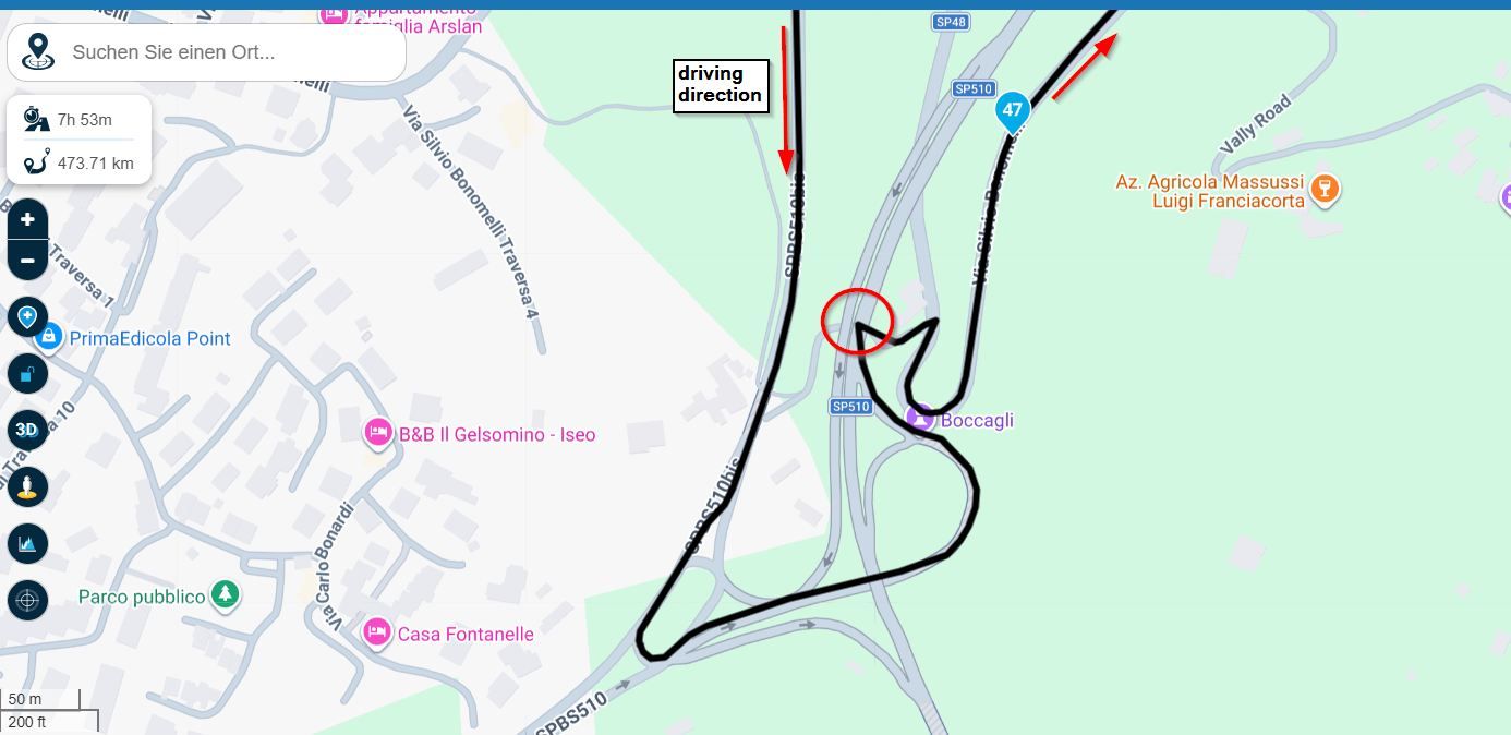
i've got a great one. woudn't it be great if i can pick up my phone, Open de Myroute app and send any route to my Navigation system wireless.
the functionality is already in a lot of systems.
Currently i can send or receive from my BMW navigator to any Garmin /bmw device any route or track.
but it is not possible trough my phone.You only have to trich the system by leting hem think the Phone is another Nav device.
from there i can get any route i want from the app, and drive for ever!!!
-
i've got a great one. woudn't it be great if i can pick up my phone, Open de Myroute app and send any route to my Navigation system wireless.
the functionality is already in a lot of systems.
Currently i can send or receive from my BMW navigator to any Garmin /bmw device any route or track.
but it is not possible trough my phone.You only have to trich the system by leting hem think the Phone is another Nav device.
from there i can get any route i want from the app, and drive for ever!!!
@Arjan-Olsthoorn I can send routes from my MRA library to my TomTom 500 using my phone. And I know that you can do the same with the new Garmin XT.
-
Nice to find myself in the list
The actual suggestion was to "search routes based on X-distance form destantion an originating Y-distance from desired starting point" But I will forgive about the shortened versionMay I deposit another one here, for Navigation?
- Expand the on-screen information with current-time, direction or compass, Height, en maybe more. It could be placed on either side of a landscape navigation screen, since more map than really needed is shown when using landscape. Maybe even move speed etc to the same location.
And for MRA?
- Since we have the heightprofile information, it could be used for a "caravan & camper" function. As opposite to the curvy road functions, Caravan and Camper drivers could benefit from leaving out slopes beyond a certain parameter.
@Con-Hennekens said in The Great Suggestion List:
Nice to find myself in the list
The actual suggestion was to "search routes based on X-distance form destantion an originating Y-distance from desired starting point" But I will forgive about the shortened versionMay I deposit another one here, for Navigation?
- Expand the on-screen information with current-time, direction or compass, Height, en maybe more. It could be placed on either side of a landscape navigation screen, since more map than really needed is shown when using landscape. Maybe even move speed etc to the same location.
And for MRA?
- Since we have the heightprofile information, it could be used for a "caravan & camper" function. As opposite to the curvy road functions, Caravan and Camper drivers could benefit from leaving out slopes beyond a certain parameter.
To add to myself (all for Navigation):
- it would be excellent to have the "next turn" indicator at the top left show the next waypoint number to which you are navigating too. That keeps track of route progress, and in case of reboots, recalculations (often start at the beginning again) it gives a better idea of to which waypoint to skip (seems an easy one!)
- in addition to the above, it would be great if a single tap on the map would show a 2d overview of the route, and your location in it. That is much easier to zoom into areas that on the standard 3d naviagtion map. It seems odd to have to quit navigation in order to see an overview of the route.
- If there is a need to skip waypoints, it is a real PITA to have to scroll through the waypoints one by one. Why not make the waypoint selectable on the map? It is already clickable, just the button "select this waypoint to skip to" is missing. I can't imagine that to be a difficult change, but if so, a dropbox in which you can select a waypoint would already be a lot of progress. Besides: pressing "close" on a selected waypoint in that view takes you out of the "skip to" function, instead of just out of the selected waypoint details. Probably a bug.
- make the "start navigation from" options a system default option. At the moment of writing it is implemented as a routing-option, and it defaults to "start of the route" each time a route loads. That can't be meant like that
Most of these additions come from some frustration because of the fact that while navigating it frequently starts recalculating (sometimes while taking a wrong turn, sometimes spontaneously) and in some of those cases it start at the beginning of the route instead of the closest waypoint (ahead!). I am not sure why, but I think it has to do with the fact that where normally the remaining time and kilometers are shown, a text shows "calculating" instead for very long and very often. The navigation runs with no problems at that point. I did not have a chance to test, but I think having the system in off-line mode helps against that.
Hello! It looks like you're interested in this conversation, but you don't have an account yet.
Getting fed up of having to scroll through the same posts each visit? When you register for an account, you'll always come back to exactly where you were before, and choose to be notified of new replies (either via email, or push notification). You'll also be able to save bookmarks and upvote posts to show your appreciation to other community members.
With your input, this post could be even better 💗
Register Login-
022225
-
08111
-
019382
-
5760
-
08171
-
0643
-
012211
-
0366