Visualizing unpaved roads
-
Re: Unpaved roads vs color contrast and permanently closed roads motorcyclists
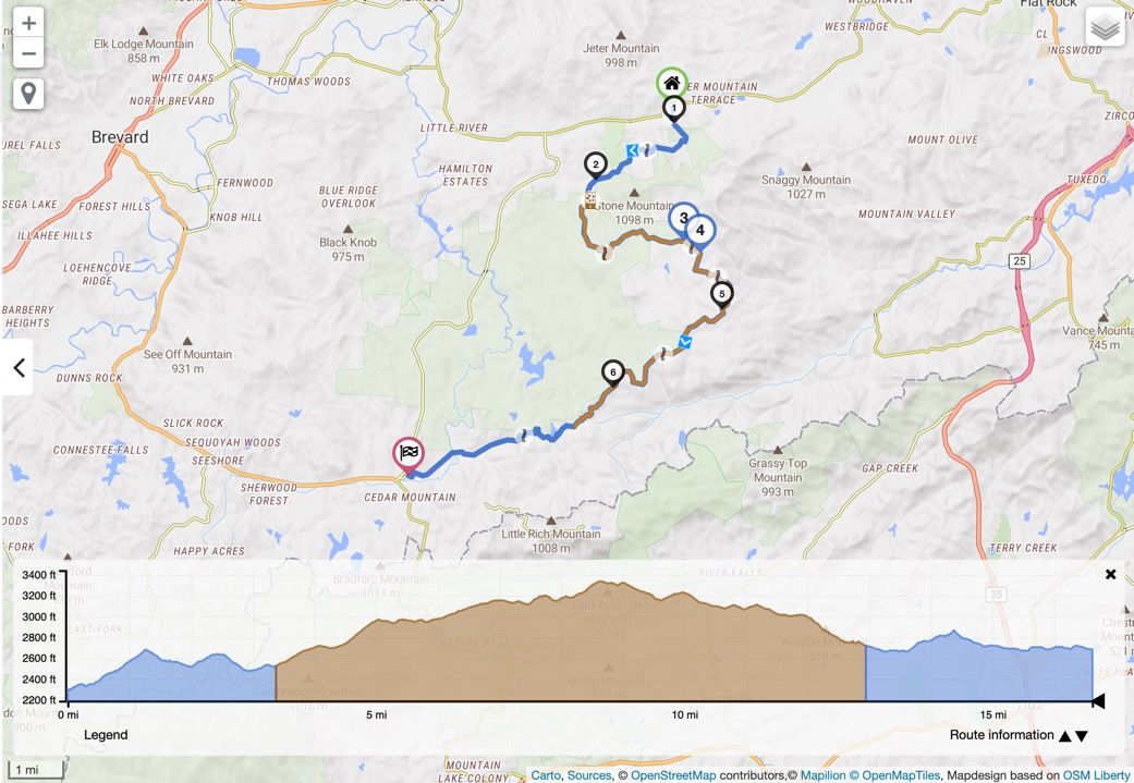
In my area I ride a combination of paved and unpaved roads when I'm on my smaller motorcycle (Husqvarna Svartpilen 401), however I like to avoid the unpaved sections if possible when I'm on my larger touring bike (Honda Goldwing). It's really nice to be able to quickly visualize that route and see if it has unpaved sections, and if so how many there are and how long they are.
The Kurvinger.de route planner solved this issue using OpenStreetMaps both on the map itself and in their elevation view. In the following screenshot the blue sections are paved and the brown are unpaved.
It would be GREAT if MRA could implement this feature in the future!
Steve
Steve Jarrell
Western North Carolina USLifetime Routeplanner Gold & Navigation Next
2025 BMW R1200GS
2025 Can-Am Spyder
DMD T865-X 8" Tablet
Garmin XT3 -
Re: Unpaved roads vs color contrast and permanently closed roads motorcyclists
In my area I ride a combination of paved and unpaved roads when I'm on my smaller motorcycle (Husqvarna Svartpilen 401), however I like to avoid the unpaved sections if possible when I'm on my larger touring bike (Honda Goldwing). It's really nice to be able to quickly visualize that route and see if it has unpaved sections, and if so how many there are and how long they are.
The Kurvinger.de route planner solved this issue using OpenStreetMaps both on the map itself and in their elevation view. In the following screenshot the blue sections are paved and the brown are unpaved.
It would be GREAT if MRA could implement this feature in the future!
Steve
@steve-jarrell
Steve open the route in the here-map and see the unsaved roads are greyGarmin Zumo XT3/XT2/XT/BMW Connected Ride Navigator/Tourstart/ MyRouteapp (The App)/...
Een dag niet gelachen is een dag niet geleefd / Een route is net zo goed als deze uitgezet is. -
@steve-jarrell
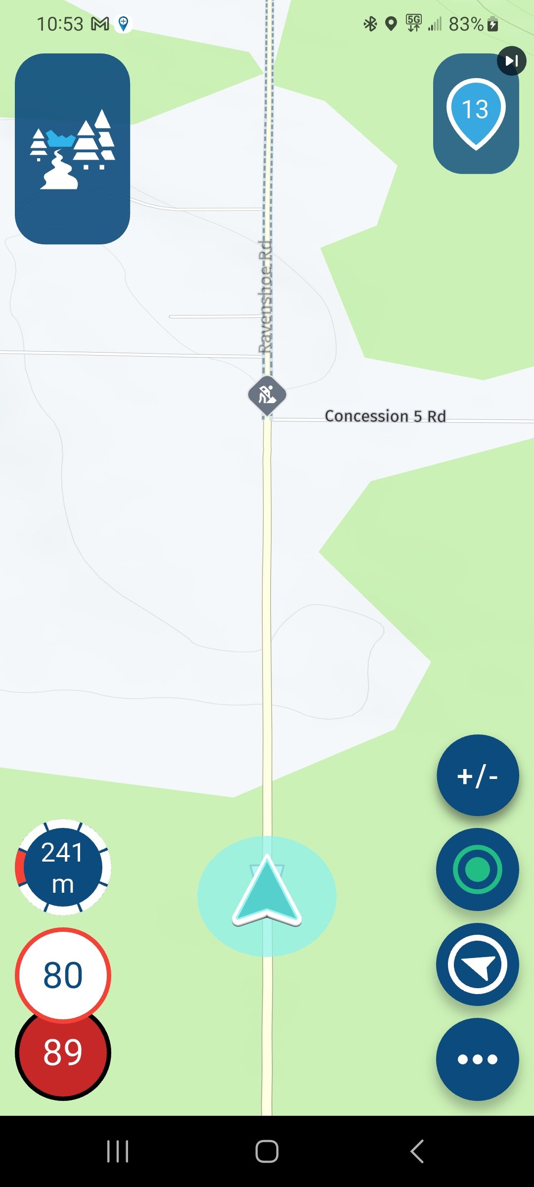
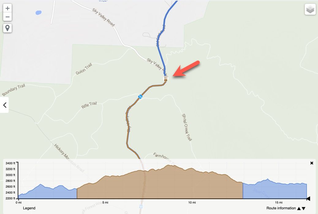
Steve open the route in the here-map and see the unsaved roads are grey@hans-van-de-ven-mra-master Unfortunately that's not the case with many unpaved roads and the Here maps (at least in my area). Even if they were shown in a slightly different color, once I've made my route the route line covers up the different color that indicates that it is a dirt road, so if I go back to the route in the future I have no idea it goes over an unpaved road just by looking at it.
Take a look at the screenshots below that illustrate what I'm talking about. Technologically it is possible to show unpaved roads very clearly as routes are being created and afterwards using OpenStreetMaps. Whether that's a feature that's worth investing development time in or not is another question entirely.
Thanks for your help! I sincerely appreciate it!
Steve
Steve Jarrell
Western North Carolina USLifetime Routeplanner Gold & Navigation Next
2025 BMW R1200GS
2025 Can-Am Spyder
DMD T865-X 8" Tablet
Garmin XT3 -
@hans-van-de-ven-mra-master Unfortunately that's not the case with many unpaved roads and the Here maps (at least in my area). Even if they were shown in a slightly different color, once I've made my route the route line covers up the different color that indicates that it is a dirt road, so if I go back to the route in the future I have no idea it goes over an unpaved road just by looking at it.
Take a look at the screenshots below that illustrate what I'm talking about. Technologically it is possible to show unpaved roads very clearly as routes are being created and afterwards using OpenStreetMaps. Whether that's a feature that's worth investing development time in or not is another question entirely.
Thanks for your help! I sincerely appreciate it!
Steve
Mm, ok, that is something that is not in the OSM map that MRA use.
I will ask the developersGarmin Zumo XT3/XT2/XT/BMW Connected Ride Navigator/Tourstart/ MyRouteapp (The App)/...
Een dag niet gelachen is een dag niet geleefd / Een route is net zo goed als deze uitgezet is. -
Mm, ok, that is something that is not in the OSM map that MRA use.
I will ask the developers@hans-van-de-ven-mra-master Thank you very much. I'm sure it's a feature that any on and off road adventure rider would find to be extremely useful.
Best regards,
Steve
Steve Jarrell
Western North Carolina USLifetime Routeplanner Gold & Navigation Next
2025 BMW R1200GS
2025 Can-Am Spyder
DMD T865-X 8" Tablet
Garmin XT3 -
@hans-van-de-ven-mra-master Thank you very much. I'm sure it's a feature that any on and off road adventure rider would find to be extremely useful.
Best regards,
Steve
@steve-jarrell I agree, more shopuld be done for off-road riders or dirty-raod riders !


-
@hans-van-de-ven-mra-master Unfortunately that's not the case with many unpaved roads and the Here maps (at least in my area). Even if they were shown in a slightly different color, once I've made my route the route line covers up the different color that indicates that it is a dirt road, so if I go back to the route in the future I have no idea it goes over an unpaved road just by looking at it.
Take a look at the screenshots below that illustrate what I'm talking about. Technologically it is possible to show unpaved roads very clearly as routes are being created and afterwards using OpenStreetMaps. Whether that's a feature that's worth investing development time in or not is another question entirely.
Thanks for your help! I sincerely appreciate it!
Steve
@steve-jarrell @steve-jarrell Steve,
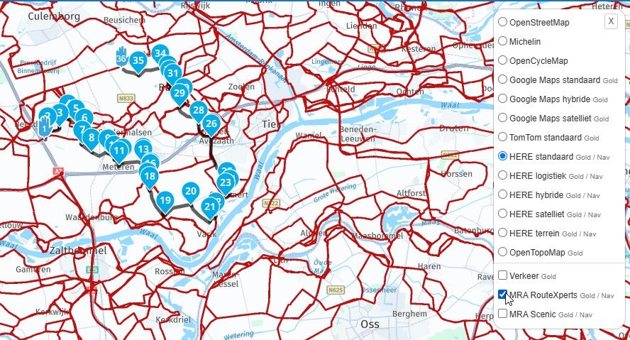
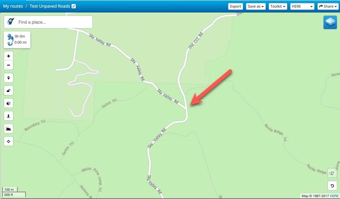
I think that will be a tough one for every developer : I have been looking at the stretch you mention, and in none of the map materials which are available in MRA Gold (and there are a lot of them), I nowhere notice any difference between paved and unpaved. I specifically mention the stretch of road one the crossing of Sky Valley Road and Old CCC road. South of that crossing and North of it should be differently colored if I understand you correctly. In none of the maps there is any difference between both.So I think not any developer will be able to show you any difference at that particular spot : it all depends on the map material the developer has available. You may edit the OpenStreetMap material there, however...
-
@steve-jarrell @steve-jarrell Steve,
I think that will be a tough one for every developer : I have been looking at the stretch you mention, and in none of the map materials which are available in MRA Gold (and there are a lot of them), I nowhere notice any difference between paved and unpaved. I specifically mention the stretch of road one the crossing of Sky Valley Road and Old CCC road. South of that crossing and North of it should be differently colored if I understand you correctly. In none of the maps there is any difference between both.So I think not any developer will be able to show you any difference at that particular spot : it all depends on the map material the developer has available. You may edit the OpenStreetMap material there, however...
@sudolea I'm not sure I understand. Just because we're not seeing the data on MRA's maps doesn't mean that it's not available from the source.
Kurviger uses OpenSource Maps as does MRA. It's obvious that the data is available in OSM and that it can be presented graphically. I export a .gpx file from MRA to Kurviger and I can see the off road portions of my trip perfectly.
I found the same issue with POIs that I posted about a couple of days ago. Kurviger and MRA both use OSM for POIs, and yet Kurviger shows MANY more pertinent POIs than MRA does.
Since OSM is open source, if there's a reason that data is available to Kurviger that's not available to MRA I don't know what it could possibly be.
As I said previously it seems like the data that's needed is there to implement this feature, however whether or not it's worth the development time to make use of it or not is another issue.
Best regards,
Steve
Steve Jarrell
Western North Carolina USLifetime Routeplanner Gold & Navigation Next
2025 BMW R1200GS
2025 Can-Am Spyder
DMD T865-X 8" Tablet
Garmin XT3 -
@steve-jarrell @steve-jarrell Steve,
I think that will be a tough one for every developer : I have been looking at the stretch you mention, and in none of the map materials which are available in MRA Gold (and there are a lot of them), I nowhere notice any difference between paved and unpaved. I specifically mention the stretch of road one the crossing of Sky Valley Road and Old CCC road. South of that crossing and North of it should be differently colored if I understand you correctly. In none of the maps there is any difference between both.So I think not any developer will be able to show you any difference at that particular spot : it all depends on the map material the developer has available. You may edit the OpenStreetMap material there, however...
@sudolea I haven't looked at the source data provided by OSM, but my guess is the "surface" tag as defined here is what is being used by Kurviger to determine which roads are unpaved.
Best regards,
Steve
-
@sudolea I'm not sure I understand. Just because we're not seeing the data on MRA's maps doesn't mean that it's not available from the source.
Kurviger uses OpenSource Maps as does MRA. It's obvious that the data is available in OSM and that it can be presented graphically. I export a .gpx file from MRA to Kurviger and I can see the off road portions of my trip perfectly.
I found the same issue with POIs that I posted about a couple of days ago. Kurviger and MRA both use OSM for POIs, and yet Kurviger shows MANY more pertinent POIs than MRA does.
Since OSM is open source, if there's a reason that data is available to Kurviger that's not available to MRA I don't know what it could possibly be.
As I said previously it seems like the data that's needed is there to implement this feature, however whether or not it's worth the development time to make use of it or not is another issue.
Best regards,
Steve
@steve-jarrell Interesting. I went and looked it up in OSM (had to log in and start editing before I saw it). Indeed, the "surface" property is different (gravel vs. asphalt). So it would (in principle) be available indeed. I missed that one

-
@sudolea I'm not sure I understand. Just because we're not seeing the data on MRA's maps doesn't mean that it's not available from the source.
Kurviger uses OpenSource Maps as does MRA. It's obvious that the data is available in OSM and that it can be presented graphically. I export a .gpx file from MRA to Kurviger and I can see the off road portions of my trip perfectly.
I found the same issue with POIs that I posted about a couple of days ago. Kurviger and MRA both use OSM for POIs, and yet Kurviger shows MANY more pertinent POIs than MRA does.
Since OSM is open source, if there's a reason that data is available to Kurviger that's not available to MRA I don't know what it could possibly be.
As I said previously it seems like the data that's needed is there to implement this feature, however whether or not it's worth the development time to make use of it or not is another issue.
Best regards,
Steve
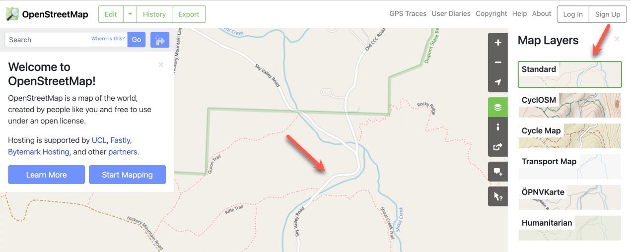
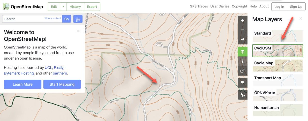
@steve-jarrell I just looked quickly at this same area directly in OSM. If I use the "Standard" layer I can't see that this section of the road is unpaved. However, if I use the "CyclOSM" layer I can it clearly.
My guess is that Kurviger is using the unpaved road data from the CyclOSM layer to depict unpaved roads on their standard maps. I don't know whether that's possible for MRA's developers to do or not, but I think it's worth consideration.
Best regards,
Steve
-
@steve-jarrell Interesting. I went and looked it up in OSM (had to log in and start editing before I saw it). Indeed, the "surface" property is different (gravel vs. asphalt). So it would (in principle) be available indeed. I missed that one
@sudolea Thanks for the update. I have just started using the OSM editor to add some local information so I may need to reach out for some help!
Thanks!
Steve
Steve Jarrell
Western North Carolina USLifetime Routeplanner Gold & Navigation Next
2025 BMW R1200GS
2025 Can-Am Spyder
DMD T865-X 8" Tablet
Garmin XT3 -
@sudolea Thanks for the update. I have just started using the OSM editor to add some local information so I may need to reach out for some help!
Thanks!
Steve
@steve-jarrell Steve, I myself have also already edited some OSM map data; most of the times I don't feel very confident about my edits. However, there is an option to ask people who are more familiar with editing the map material to audit your changes before they get "live"...
-
@steve-jarrell Steve, I myself have also already edited some OSM map data; most of the times I don't feel very confident about my edits. However, there is an option to ask people who are more familiar with editing the map material to audit your changes before they get "live"...
@sudolea Thanks. Yes, I saw and checked that option. It's not real intuitive. It will tell you there's a potential problem, but it doesn't give you hardly any indication of what the problem is or how to resolve it. I guess I'll have to watch a few more of the videos and read more of the manual. I'll figure out the basics.... somehow..... someday.
")
Thanks!
Steve
-
Re: Unpaved roads vs color contrast and permanently closed roads motorcyclists
In my area I ride a combination of paved and unpaved roads when I'm on my smaller motorcycle (Husqvarna Svartpilen 401), however I like to avoid the unpaved sections if possible when I'm on my larger touring bike (Honda Goldwing). It's really nice to be able to quickly visualize that route and see if it has unpaved sections, and if so how many there are and how long they are.
The Kurvinger.de route planner solved this issue using OpenStreetMaps both on the map itself and in their elevation view. In the following screenshot the blue sections are paved and the brown are unpaved.
It would be GREAT if MRA could implement this feature in the future!
Steve
@Steve-Jarrell Steve, I am totally with you on that request! I is a big missing part in MRA.
Btw, I was just playing with Kurviger (never heard of it before your mentioning it). I don't get to see unpaved roads like you do... Is it only for subscribed members?
Thanks!Positive emotions are worth every penny ;)
-
@Steve-Jarrell Steve, I am totally with you on that request! I is a big missing part in MRA.
Btw, I was just playing with Kurviger (never heard of it before your mentioning it). I don't get to see unpaved roads like you do... Is it only for subscribed members?
Thanks!@Lenny-O That is a paid version (Tourer or Tourer+) feature.
Steve Jarrell
Western North Carolina USLifetime Routeplanner Gold & Navigation Next
2025 BMW R1200GS
2025 Can-Am Spyder
DMD T865-X 8" Tablet
Garmin XT3 -
@Lenny-O That is a paid version (Tourer or Tourer+) feature.
@Steve-Jarrell Thank you!
As of late, we still have no way to tell in MRA, right?Positive emotions are worth every penny ;)
-
@Steve-Jarrell Thank you!
As of late, we still have no way to tell in MRA, right?@Lenny-O Not that I know of.
MRA does have an "avoid unpaved roads" option but that isn't the same thing as visualizing the unpaved section. For example, the unpaved section may only be 100 meters long and would be perfectly rideable but MRA will completely avoid it, many times taking you on a much longer and much less desirable route.
Steve Jarrell
Western North Carolina USLifetime Routeplanner Gold & Navigation Next
2025 BMW R1200GS
2025 Can-Am Spyder
DMD T865-X 8" Tablet
Garmin XT3 -
@Lenny-O Not that I know of.
MRA does have an "avoid unpaved roads" option but that isn't the same thing as visualizing the unpaved section. For example, the unpaved section may only be 100 meters long and would be perfectly rideable but MRA will completely avoid it, many times taking you on a much longer and much less desirable route.
@Steve-Jarrell MRA sends you on unpaved road even if Avoid unpaved roads is selected... That's my biggest problem with that.
Positive emotions are worth every penny ;)
-
@Steve-Jarrell MRA sends you on unpaved road even if Avoid unpaved roads is selected... That's my biggest problem with that.
@Lenny-O Which maps are you using? If you're not already using the OSM maps see if using them solves that issue. I have had some issues with the HERE/Garmin maps so I always double check a route using the OSM maps.
Steve Jarrell
Western North Carolina USLifetime Routeplanner Gold & Navigation Next
2025 BMW R1200GS
2025 Can-Am Spyder
DMD T865-X 8" Tablet
Garmin XT3
Hello! It looks like you're interested in this conversation, but you don't have an account yet.
Getting fed up of having to scroll through the same posts each visit? When you register for an account, you'll always come back to exactly where you were before, and choose to be notified of new replies (either via email, or push notification). You'll also be able to save bookmarks and upvote posts to show your appreciation to other community members.
With your input, this post could be even better 💗
Register Login-
08124
-
0473
-
0367
-
718173
-
027
-
06171
-
018