
GPX Versions 1.1 vs 1.2 for Garmin Visually Explained
-
I haven't found any clear explanation that made sense to me regarding the differences and pros and cons of the gpx 1.1 and 1.2 export formats. I'll outline what I have found after hours of testing and hopefully it will be of some help.
I'll start off with the basics for anyone that's totally new to .gpx files to lay the groundwork, then I'll include screenshot examples that clearly show the differences. I know the first part of this will be unnecessary for most of you, but for any new users I think it will be helpful.
THE BASICS
Bear in mind these examples are for the Garmin XT series of GPS devices. 1.2 may or may not work the same on other gps units (it probably doesn't) but even so the limitations of the 1.1 format will be the same regardless of what type of unit that you may have and it's important know how to work around them.
A .gpx file is a simple text file. You can open it with any text editor and inspect it. The file basically has three sections... 1) the header, 2) the route information, and 3) the track information.
The header section tells the GPS the general information about the file, the route section gives the GPS the information that it needs to create the turn-by-turn route when it imports the .gpx file, and the track is simple gps latitude and longitude coordinates (breadcrumbs) that form a simple path. A track doesn't know if it's on-road or off-road, or in the middle of a lake or the ocean. It's simply a series of coordinates (many times thousands of them in a file).
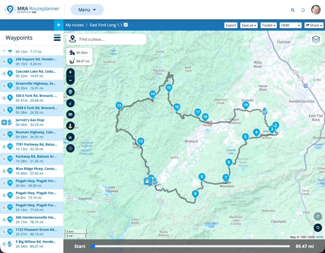
In MRA, or pretty much any route creation program, you create two basic elements that will form the route and track. You have waypoint (aka via points, but we'll just ) and shaping points. Waypoint you must go to (either a stop or pass through it) unless you purposely choose to skip it, and shaping points are just that, their purpose is to solely shape the route. Here's an example of a simple route in MRA showing 3 waypoints (Start, Finish and a gas stop) and 17 shaping points that (try to) force the route to go where I wanted it to.
When you export the route (save as and upload) to your GPS, whether it's in 1.1 or 1.2 format, the GPS takes the .gpx file, reads it and creates a route based on the information in the route section apply its own logic (shortest route, fastest route, etc) and that's the route that you see on your GPS. The track is also imported from the .gpx file, and it should always look exactly the same on your GPS as the route looked in MRA.
SO, ENOUGH OF THE BASICS... WHAT'S THE PRACTICAL DIFFERENCE IN THE GPX 1.1 AND 1.2 FORMATS???
The primary difference between the two formats is quite simple, but the difference in now they create a route is significant! Both formats are basically the same except for what's in the Routes section, but this is a BIG difference.
1.1 Route
In our example MRA screenshot above, when the route is exported in (saved as) gpx 1.1 format it contains the 3 waypoints and the 17 shaping points. When the 1.1 file is imported into the Garmin XT GPS, the GPS begins at the first waypoint, then finds the shortest or fastest route (depending on your navigation settings) to shaping point #1, then to shaping point #2 until it gets to the gas stop waypoint (#10), then it continues by finding the shortest or fastest route to the next shaping point (#11 in our example) and so on until it reaches the next waypoint (which, in our case is the end of the route.1.2 Route
When the MRA route is exported in (saved as) .gpx 1.2 format the route section DOES NOT include any shaping points! Instead, it includes gps latitude and longitude coordinates in its route section just like those that are included in its track section. When the gpx 1.2 file is imported into the Garmin XT GPS, it starts at the beginning waypoint, then follows the GPS latitude and longitude coordinates to the gas stop waypoint (#10) then it continues following the GPS coordinates to the next waypoint (the end of the route in our simple example).Summary
Finally! The 1.1 format contains route shaping points that the Garmin XT GPS uses when it creates its route based on the criteria in its navigation settings, and the 1.2 format uses route gps coordinates (just like a track) that isn't affected by the Garmin's route creation logic when the route is created.
So, What Does This Look Like VISUALLY?
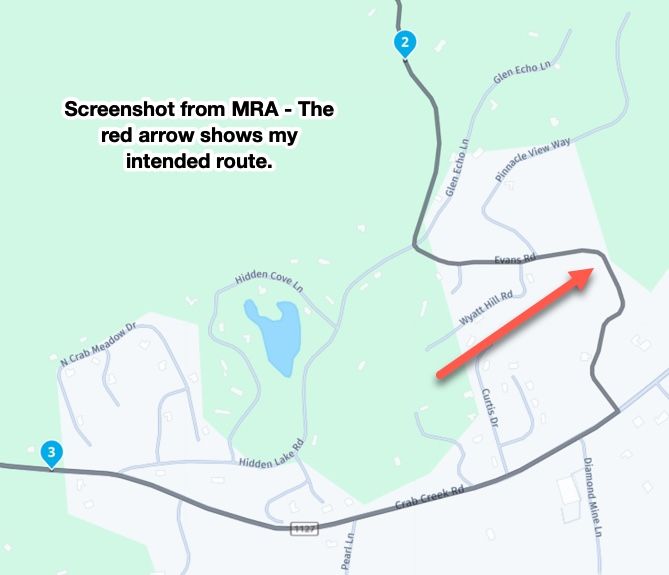
Ok, here's a section of the route above shown in a screenshot from MRA. As you can see the route I planned goes down Evans Road until it meets Crab Creek Road.
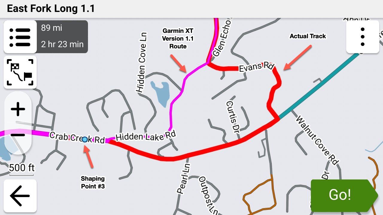
So I exported this route in 1.1 format and imported into my Garmin XT3 and my navigation setting was set to "Fastest". The XT decided that "Fastest" (and it did the same when I set it to "Shortest") way between to take Hidden Lake Road instead (purple line) even though the track clearly showed that I intended to go down Evans Road (you can show the track and route simultaneously with the XT3 which I did here for clarity).
Next, I exported this EXACT same route from MRA in gpx 1.2 format and imported it into my Garmin XT3. Notice two important things - the route followed what I was seeing in MRA, and there are NO shaping points.
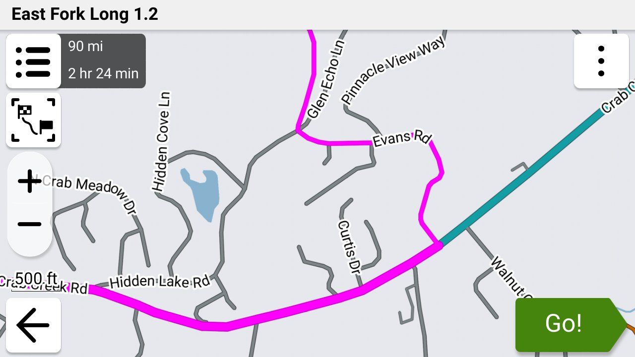
While this is a very small example of what happens during the Garmin's route creation with a gpx 1.1 file, on a large, complex route the Garmin can make a LOT of unintended changes. I have wound up on nasty gravel roads on a Goldwing, down back alleys, missed curvy sections that I wanted to ride, etc. etc. because of this issue.
I'm exclusively using the gpx 1.2 format using the "Save As" feature and uploading the file manually to my XT3 using a USB cable as I described in detail earlier today in this post.
So What if My GPS Doesn't Support the 1.2 Format?
Use a LOT of shaping points to force the GPS not to "cut corners". Then export it (or "save as") in the 1.1 format and import it into your GPS. Show the route and the track simultaneously (you'll have to figure out how do this on your own.... your owner's manual is a good place to start).
You can normally spot the differences in the route and track (which was your intended route) fairly easily by looking for where their paths diverge. This is much easier if you can set your track to a color that's completely different from your route color.
You can also compare the mileage shown for the route in your GPS and MRA and they should be very close.
If you see any issues, go back into MRA and add shaping points to fix the problem(s). Delete the route and track from your GPS, export it again from MRA then import it into your GPS and check it again. It may take several tries if you want your GPS route and the route that you see in MRA to match exactly.
Steve
p.s. Here's a link to the example MRA route that I used above. Ignore the 1.1 in the filename as I had 2 identical MRA routes, on with a 1 in the filename and 1 with a 2 just so that I could test quickly and tell them apart. This file can be exported as gpx 1.1 or 1.2 to achieve the same results as I did above.
-
 Steve Jarrell referenced this topic on
-
Thankx @steve-jarrell fir making this perfectly clear. That’s why we advise thé usées to use the 1.2 format to export there besutifull MRA routes to Garmin devices and keep them as they intended. No Garmin recalculating bulls…
-
I think this was known by many already. GPX 1.2 is basically a track with VIA points present as POI. Besides that, if you save a GPX 1.1 there is also a track included as well as a route.
-
Just to be clear as well, gpx format 1.2 is not an official format!
See: https://www.topografix.com/gpx.asp1.1 is still the official format.
1.2 format is intended for Garmin usage.
1.2 format is introduced by MyRouteApp just to avoid some shortcomings in the 1.1 format. -
Just to be clear as well, gpx format 1.2 is not an official format!
See: https://www.topografix.com/gpx.asp1.1 is still the official format.
1.2 format is intended for Garmin usage.
1.2 format is introduced by MyRouteApp just to avoid some shortcomings in the 1.1 format.@nomko Yes you are wright but its the only format that keeps Garmin from doing its own gecalculating trick witch messes up your route
-
Very good read! Thank you all!
I would like to bring another twist into this
It has to do with the Avoidances set in your Garmin.
Let's say your MRA planned route has some Highways you plan to ride, but your Garmin is set to avoid Highways.
If format 1.1 is used to transfer your route from MRA to the Garmin, when you select the route for navigation on the Garmin, it will calculate the route and change it to avoid the Highways.
But when format 1.2 is used, then Garmin will ignore your Highway avoidance preference and will go on the intended Highways just like you planned it.
So, 1.2 format is eliminating another potential discrepancy between MRA planned route and Garmin's calculation.
Please, correct me if I am wrong! -
When using a Garmin don’t set any avoidance items. It will mess up your route. For Pete’s sake deactivate recalculating
-
When using a Garmin don’t set any avoidance items. It will mess up your route. For Pete’s sake deactivate recalculating
@Marinus-van-Deudekom I completely agree that Garmin's avoidances certainly mess up a gpx 1.1 route in sometimes VERY unpredictable ways.
However, Garmin's avoidance settings do not in any way alter a gpx 1.2 route as the Garmin is forced to follow the gps coordinates in the route section of the file and not the shaping points or, in the case of this example, just the beginning and ending waypoints. That is the BIG difference between the gpx 1.1 and 1.2 formats.
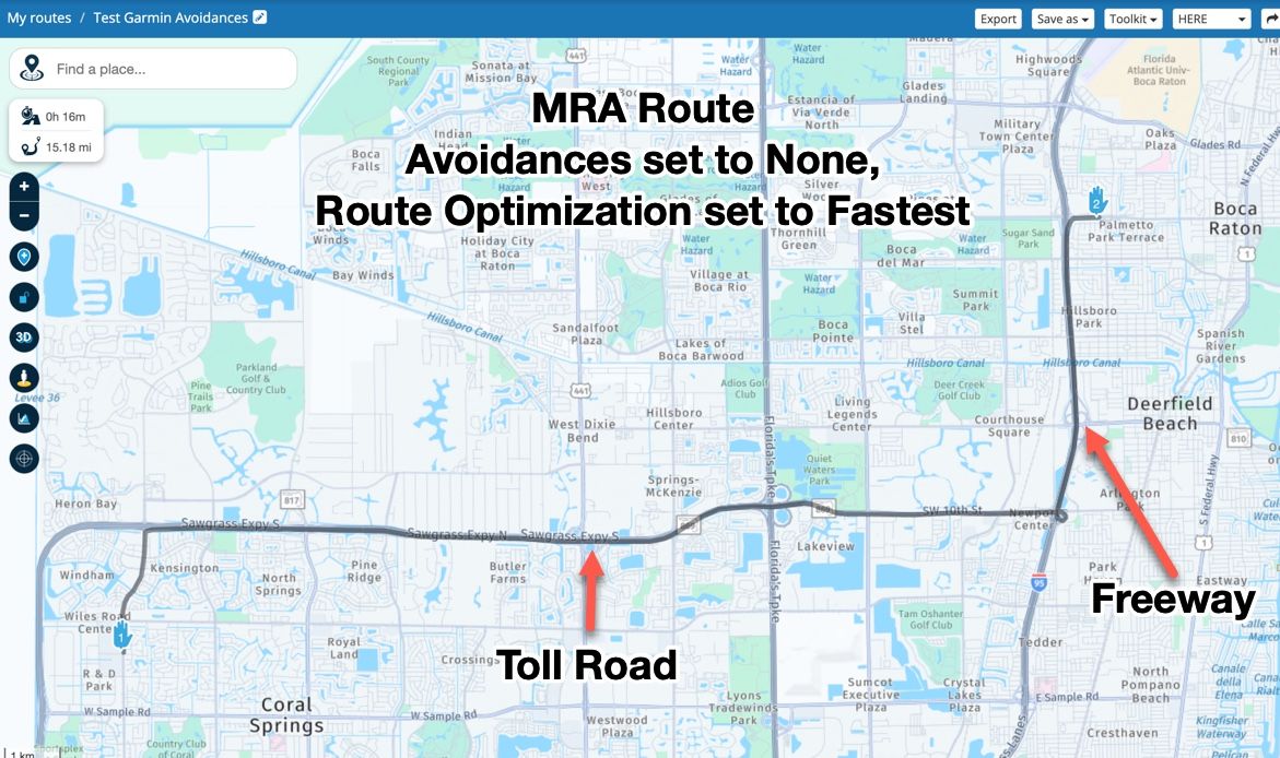
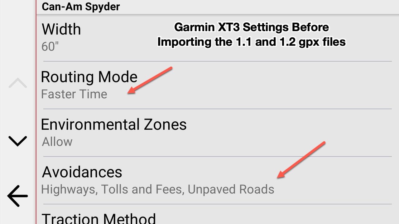
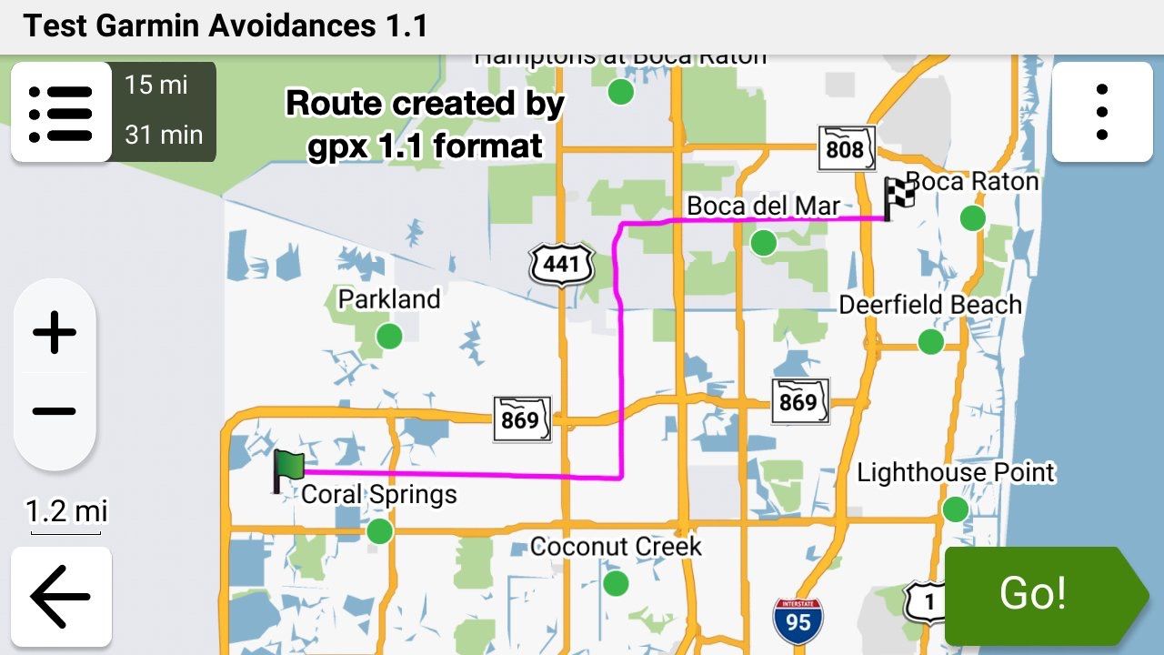
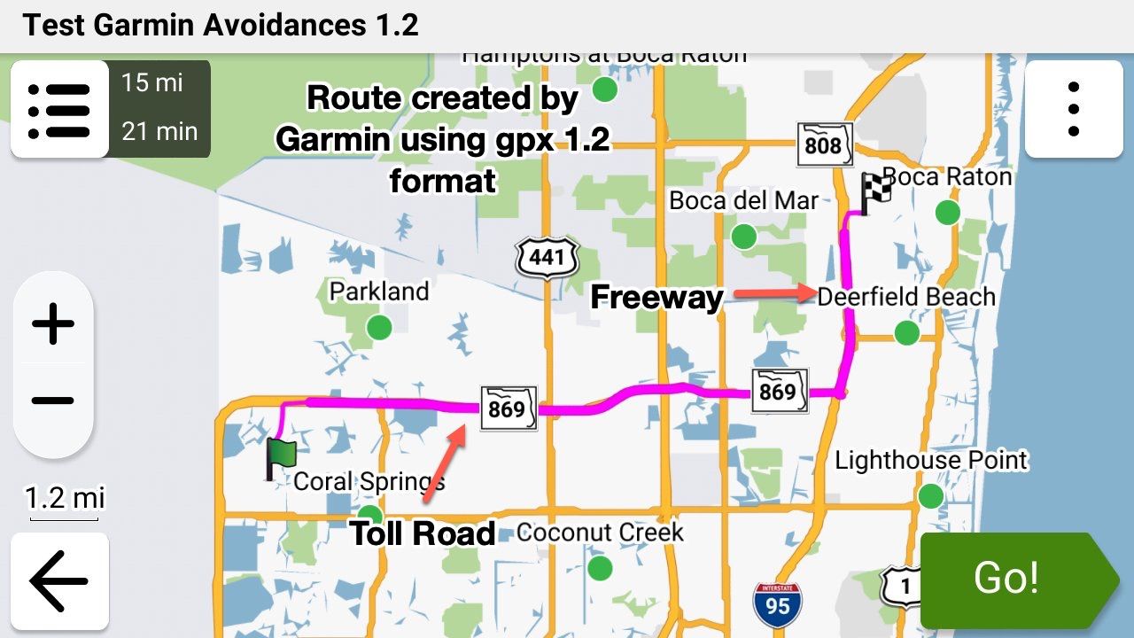
The following example route and screenshots show this clearly. Here's a very simple 2 waypoint (Start and Finish) route in MRA that I created this morning to show this visually. In this example route my MRA's Route Optimisation is set to "Fastest" and my Garmin's is set to "Fastest" and its Avoids are set to "Freeways" and "Toll Roads".
The EXACT same route was saved as gpx 1.1 and then 1.2 formats and then both formats were imported into my Garmin XT3. You can see that the Garmin totally ignored the planned route when importing using the gpx 1.1 format file and followed its Avoid settings, however it followed the planned route exactly when importing the route using gpx 1.2 format file and totally ignored its Avoid settings.
-
That is a cool conclusion @steve-jarrell
Tread didn't mess up the 1.2 (which I always use on my XT1)?
So, could you say, that it will work on the XT2 exactly the same?Met andere apps maak je een route, met MRA componeer je een route!
Ducati Monster 1200 met Garmin Zümo XT
Fiat 124 Spider/Camper Dethleffs met Navigation-App op Samsung Tab Active4 Pro
MRA Lifetime Gold -
That is a cool conclusion @steve-jarrell
Tread didn't mess up the 1.2 (which I always use on my XT1)?
So, could you say, that it will work on the XT2 exactly the same?@Travellexxie I have no idea of how the Tread app will work with anyone else's X1 or X2 (or X3 for that matter). All that I can relate is what happened to me.
Let me preface this by saying that this was MY experience, and others may have a perfectly good experience with the XT3 and data synching. It is perhaps caused by my refusal to turn over control of my data transfer to the XT3 to any app or cloud service (see my post here on how I transfer and why).
The Tread app provides 3 key features. It provides:
- A data connection from your phone to the XT that enables the realtime traffic and weather reporting on the XT (a REALLY neat feature).
-
A connection to whatever bluetooth headset that you have (a Cardo Edge in my case) already hooked up to your phone so you don't have to hook your headset up to both. (another REALLY neat feature).
-
A data connection to explore.garmin.com that allows data transfer, including .gpx files, to and from explore.garmin.com (This wound up being a TERRIBLE "feature" for me as I'll describe below.)
The Tread app's features 1 and 2 work GREAT and are very useful. Even though I didn't need or want the data / gpx file transfer feature as I use a USB cable, when I was originally setting up my XT3 one of the initial setup prompts was something like "Would you like to back your data up to explore.garmin.com" and I selected "Yes" as I figured what harm could having an online backup do?
Wrong!! That was a REALLY BIG mistake for me! As I added new .gpx files manually via a USB cable connection, and then converted them into routes and tracks, the XT3 tried to synch them to the cloud. It was painfully slow, and every time I'd go online with my web browser and check my Garmin Explore account the files and collections were NEVER synched correctly or completely.
So I figured "No big deal, I'll just go into the Tread app and / or XT3's settings and turn the synching feature off." NOPE! There is simply NO WAY to turn off the data synching feature once you've turned it on, either in the Tread app or in the XT3! I couldn't believe it (if anyone can prove me wrong I'll GLADLY admit my failure!!!).
I searched all over the internet and found several suggestions for how to stop synching such as completely removing the app and its bluetooth settings, and even getting into the "hidden" developer's area of the XT3 and deleting the user database. I'm very computer literate, and I did all of these things multiple times to absolutely no avail. Perhaps they worked for the XT1 and / or the XT2, but I could not "unsynch" the XT3 - Tread - Garmin cloud data connection no matter what I tried.
I FINALLY gave up and totally removed the Tread app (again), removed its bluetooth settings in my phone) again, AND did a total reset on the XT3 (Settings - Device - Reset). Then I reinstall the Tread app and started the XT3 back up, and when I got to the deceptive prompt about backing up to the cloud I said NO!
After that everything worked perfectly and my XT3 no longer tries to synch with Garmin's cloud service. Obviously the setting to synch with Garmin's cloud service is in the XT3's hidden settings, and once you turn it on the only way that you can turn it off is to do a total reset. Not giving the user the ability to turn synching off is absolutely ridiculous and one of the most idiotic things that I've ever seen from Garmin (except for the TERRIBLE user interface on Basecamp).
Sorry for such a long answer to a short question but if it helps even one person avoid the Garmin "backup to the cloud" trap it was worth it!
-
 Nick Carthew moved this topic from [Web] Suggestions and Discussion on
-
Nick Carthew pinned this topic on
-
@steve-jarrell in your current use are you saying that with an XT3 and using Tread app that you can have features 1 & 2 (traffic and Bluetooth headset) WITHOUT having 3 (syncing routes with Garmin cloud)?
-
I can answer about 1.2 and Tread. 1.2 is an MRA invention which I used almost exclusively on my previous, non-XT Zumo and it's very good to easily keep your route the same as your track. Zumos recognise it and plot the routes but Tread doesn't. If you allow Trad to sync with a 1.2 route, it will almost certainly change it to follow its own settings/algorithms.
With any Zumo using a 1.2 route, you must turn off auto-recalculate - otherwise it will! You may well end up with a totally different route between your via points. Also, you will not be redirected back onto your route should you deviate from it.
The XT2 & 3 will accept 1.2 but only via cable transfer. If you have deleted Explore from Tread by resetting, you will not be able to transfer a route wirelessly other than via an SD card.
My answer to all these problems, and I realise others have not had the same success, is to use 1.1 (route, track POI) with plenty of shaping points to pin the Zumo/Tread calculated route to my track. Once I've planned my route on MRA, I export it into Tread to see if the route and track coincide. If not, I can add another shaping point where necessary and look again. Sounds a bit of a faff but it's really quite quick and easy once you've done it a few times.
With 1.1, you can leave auto-recalculate switched on and you will be redirected back to your route if you wander for any reason, including road closures but that's another subject.
I really like being able to plan on MRA when away and transfer to the Zumo so Tread is my preferred option. If in a hurry, just using an MRA track works well too.
A long way of saying Tread and 1.2 don't play together. -
@steve-jarrell in your current use are you saying that with an XT3 and using Tread app that you can have features 1 & 2 (traffic and Bluetooth headset) WITHOUT having 3 (syncing routes with Garmin cloud)?
@Will-Brooks YES, exactly!
If you don't turn on data synching when you first setup the X3 features 1 and 2 still work just fine. These features rely on the bluetooth connection with your phone, not the data synching link with Garmin Explore.
Don't establish a bluetooth connection manually between your phone and the X3. When you pair your Tread app with your X3 it will ask you if you want to establish the bluetooth connection. When you proceed the Tread app will pair your XT with your phone via bluetooth.
In your phone's bluetooth settings you will then see a connection to your X3 just as if you would have manually connected them without the Tread app, however since the Tread app initiated the connection it can send the verbal instructions from the X3 to whatever bluetooth headset that your phone is using, and it can enable your XT3 to get traffic and weather information as well.
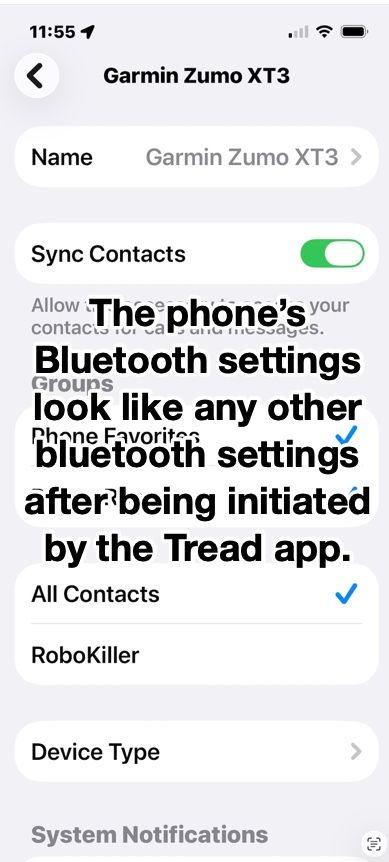
I have a Cardo unit in my helmet connected to my iPhone directly. It is not directly connected to my XT3 and it works just as if it was. I was also pleasantly surprised during testing the if I use my Apple AirPods they work perfectly as well even though they're not paired with my XT3. The ONLY bluetooth connection to my XT from my phone is the one that the Tread app set up.
The bluetooth connection in the phone looks just like any other bluetooth connection, but since it was initiated by the Tread app somehow the app can reroute the XT3's voice output to the phone's connected headset, and also use the phones data for the XT3's weather and traffic. AWESOME FEATURES!
-
Very good read! Thank you all!
I would like to bring another twist into this
It has to do with the Avoidances set in your Garmin.
Let's say your MRA planned route has some Highways you plan to ride, but your Garmin is set to avoid Highways.
If format 1.1 is used to transfer your route from MRA to the Garmin, when you select the route for navigation on the Garmin, it will calculate the route and change it to avoid the Highways.
But when format 1.2 is used, then Garmin will ignore your Highway avoidance preference and will go on the intended Highways just like you planned it.
So, 1.2 format is eliminating another potential discrepancy between MRA planned route and Garmin's calculation.
Please, correct me if I am wrong!@Lenny-O You are 100% correct.
-
Steve Jarrell referenced this topic on
-
I can answer about 1.2 and Tread. 1.2 is an MRA invention which I used almost exclusively on my previous, non-XT Zumo and it's very good to easily keep your route the same as your track. Zumos recognise it and plot the routes but Tread doesn't. If you allow Trad to sync with a 1.2 route, it will almost certainly change it to follow its own settings/algorithms.
With any Zumo using a 1.2 route, you must turn off auto-recalculate - otherwise it will! You may well end up with a totally different route between your via points. Also, you will not be redirected back onto your route should you deviate from it.
The XT2 & 3 will accept 1.2 but only via cable transfer. If you have deleted Explore from Tread by resetting, you will not be able to transfer a route wirelessly other than via an SD card.
My answer to all these problems, and I realise others have not had the same success, is to use 1.1 (route, track POI) with plenty of shaping points to pin the Zumo/Tread calculated route to my track. Once I've planned my route on MRA, I export it into Tread to see if the route and track coincide. If not, I can add another shaping point where necessary and look again. Sounds a bit of a faff but it's really quite quick and easy once you've done it a few times.
With 1.1, you can leave auto-recalculate switched on and you will be redirected back to your route if you wander for any reason, including road closures but that's another subject.
I really like being able to plan on MRA when away and transfer to the Zumo so Tread is my preferred option. If in a hurry, just using an MRA track works well too.
A long way of saying Tread and 1.2 don't play together. -
Have you read the manual page 47?
https://www8.garmin.com/manuals/webhelp/GUID-7E13E879-D2C7-4B0C-9E63-CD693B2E7042/EN-US/zumo_XT2_OM_EN-US.pdf -
@Carl-Lee
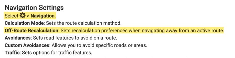
Hi, I have an XT2 and cannot figure out how to turn off auto-recalculate off? Can you let me know how to turn off auto-recalculate, please?As @reinhard-32 said, this is from page 47 of the XT2 manual. My XT3 is a lttle different, but this is from the .pdf manual downloaded from Garmin's site.
-
Thank you Steve. I did eventually figure this out. I thought there was a different setting used during import of files.
@OkayJim You're very welcome. I'm glad that you figured it out!








Hello! It looks like you're interested in this conversation, but you don't have an account yet.
Getting fed up of having to scroll through the same posts each visit? When you register for an account, you'll always come back to exactly where you were before, and choose to be notified of new replies (either via email, or push notification). You'll also be able to save bookmarks and upvote posts to show your appreciation to other community members.
With your input, this post could be even better 💗
Register Login
-
 010325
-
 0346
0346
-
17254
-
 016695