Skip to content
  • Categories
  • Recent
  • Popular
  • Support
  • MyRoute-app
Collapse
Brand Logo

MRA Community Forum

  1. Home
  2. MyRoute-app Routeplanner
  3. [Web] Suggestions and Discussion
  4. Distances between waypoints

Distances between waypoints

Scheduled Pinned Locked Moved [Web] Suggestions and Discussion
100
12 Posts 11 Posters 2.2k Views 5 Watching
  • Oldest to Newest
  • Newest to Oldest
  • Most Votes
Reply
  • Reply as topic
Log in to reply
This topic has been deleted. Only users with topic management privileges can see it.
  • Wallace Shackletonundefined Wallace Shackleton

    How about including the distance between each waypoints rather than a cumulative number?
    eg,
    Start .......0km 0km
    Waypoint 1 100km 100km
    Waypoint 2 200km 300km
    Waypoint 2 400km 700km

    This would make planning especially between stages of a big trip a whole lot easier when roughing out a route, as compared to looking at big numbers such as 2372km, 2606 km and 3204km and deciding if that is an achievable distance between waypoints/destinations.

    Brian McGundefined Offline
    Brian McGundefined Offline
    Brian McG
    wrote on last edited by
    #2

    @Wallace-Shackleton I sort of am onboard with this idea as I do spend a lot of time subtracting the distance from one point to another
    however I would definetley not want to see both the cumulative & individual distances displayed at the same time
    my preference would be for a toggle switch at the top of the waypoint list that enabled the user to flip between the different measurement styles

    BlackView BV7100, Android 12
    Normaly navigate Routes in Offline mode with Offline Maps

    1 Reply Last reply
    2
    • Nick Carthewundefined Online
      Nick Carthewundefined Online
      Nick Carthew
      RouteXpert
      wrote on last edited by
      #3

      For those with a Gold subscription, the calculator in the toolkit can tell you the time and distance between any two route points.

      Always willing to help if I can.
      Triumph Tiger 1200 XRT called Tina.
      MRA Navigation Next and SilverFox BJ8

      1 Reply Last reply
      2
      • Lex.Kloet.RXundefined Offline
        Lex.Kloet.RXundefined Offline
        Lex.Kloet.RX
        RouteXpert
        wrote on last edited by
        #4

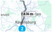
        When you want to know the distance anywhere in your routes, simply click on the altitude gaphics map
        2a04ec85-071f-4bab-9e3a-e7b0d62e38fb-image.png
        Now hoover with your mouse over the graphic and you see the exact position and altitude after xxx km.
        4ba8f74f-51f5-4f39-be6c-938a9ddf6622-image.png
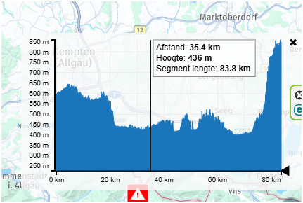
        On the map this position is sowed with a little flag with the altitude. In this way you can schedule your route very precisely
        7f767f5e-5e9b-41a7-b598-c929e0f5ba37-image.png

        Met andere apps maak je een route, met MRA componeer je een route!

        Ducati Monster 1200 met Garmin Zümo XT
        Fiat 124 Spider/Camper Dethleffs met Navigation-App op Samsung Tab Active4 Pro
        MRA Lifetime Gold

        1 Reply Last reply
        3
        • Hubert Thoringundefined Offline
          Hubert Thoringundefined Offline
          Hubert Thoring
          Valued contributor
          wrote on last edited by
          #5

          Hey @Wallace-Shackleton ,
          The waypoints list offers the km between the WP always added up.

          VG 👋

          VG Hubert
          Beta Test "Next App" dazu die Hardware .
          iPad 9. Gen iOS 26.3.1a / iPhone 16e iOS 26.3.1a / iPhone Xr iOS 18.7.7 / PC mit MS Win11 /❗️MyRoute-App im Cradel und Remotek-One❗️ Info zu MRA & Remotek One

          1 Reply Last reply
          0
          • Matjaz Valjavecundefined Offline
            Matjaz Valjavecundefined Offline
            Matjaz Valjavec
            wrote on last edited by
            #6

            Hey MRA team... I totally agree with @Wallace-Shackleton. Normally you always plan whole length of journey at first, then later split the route in proper daily rides. Therefore the distance between consecutive waypoints in the waypoints list would be very, very useful, a really cool feature. BTW: all other solutions above are clumsy and not really useful. Best regards, Matjaz

            Jörgenundefined Peter Zehentreiterundefined 2 Replies Last reply
            0
            • Matjaz Valjavecundefined Matjaz Valjavec

              Hey MRA team... I totally agree with @Wallace-Shackleton. Normally you always plan whole length of journey at first, then later split the route in proper daily rides. Therefore the distance between consecutive waypoints in the waypoints list would be very, very useful, a really cool feature. BTW: all other solutions above are clumsy and not really useful. Best regards, Matjaz

              Jörgenundefined Offline
              Jörgenundefined Offline
              Jörgen
              Valued contributor
              wrote on last edited by
              #7

              @Matjaz-Valjavec said in Distances between waypoints:

              Hey MRA team... I totally agree with @Wallace-Shackleton. Normally you always plan whole length of journey at first, then later split the route in proper daily rides. Therefore the distance between consecutive waypoints in the waypoints list would be very, very useful, a really cool feature. BTW: all other solutions above are clumsy and not really useful. Best regards, Matjaz

              I do not agree, the planner gives you all tools that are needed to do any kind of calculation for any perfect route.

              Hardware
              iPhone 12 pro (iOS 26.2.1)
              iPad (7.Gen.) 18.7.3
              Oukitel RT3 Pro (Andr. 14)
              Wireless CarPlay mit (Elebest C650)
              Wired CarPlay (SEAT Arona - 2021)
              MRA Workshops in Deutsch sind hier zu finden

              1 Reply Last reply
              1
              • Matjaz Valjavecundefined Matjaz Valjavec

                Hey MRA team... I totally agree with @Wallace-Shackleton. Normally you always plan whole length of journey at first, then later split the route in proper daily rides. Therefore the distance between consecutive waypoints in the waypoints list would be very, very useful, a really cool feature. BTW: all other solutions above are clumsy and not really useful. Best regards, Matjaz

                Peter Zehentreiterundefined Offline
                Peter Zehentreiterundefined Offline
                Peter Zehentreiter
                wrote on last edited by
                #8

                @Matjaz-Valjavec said in Distances between waypoints:

                BTW: all other solutions above are clumsy and not really useful.

                That's always in the eye of the beholder.
                Every platform has its own characteristics and approaches to achieving the goal.

                Once I have decided on a platform, I need to familiarize myself with the options available, then I can intuitively use the tools at my disposal.

                But to say that the options are not helpful but cumbersome is definitely NOT correct.

                I agree with Jörgen 100% on this.
                The platform includes all the tools you need to plan a perfect tour.

                BMW R 1250 GS
                MRA Navigation & SilverFox C1 Controller
                BMW Connected Ride Cradle
                Wunderlich USB Ladebox mit Quadlock
                Pixel 9 "online"
                SPC Universal mount
                Motorola Edge 40 "offline"
                Sena SLR 3
                Sena 50 R

                1 Reply Last reply
                3
                • Tony 13undefined Offline
                  Tony 13undefined Offline
                  Tony 13
                  wrote on last edited by
                  #9

                  I would still like to be able to toggle between cumulative and individual distances

                  1 Reply Last reply
                  1
                  • Allan Greigundefined Offline
                    Allan Greigundefined Offline
                    Allan Greig
                    wrote on last edited by
                    #10

                    I’ve only just discovered the ‘distance between waypoints’ feature ! What I do with a 2-3 day transit route, is compile the entire route in one, and then select “Expand” from the toolkit. I generally get away with 50. It appears that the added waypoints are based on time travelled, so if we plan on departing 8am - there is generally a waypoint very close to ‘each hour’. I re-colour each hourly waypoint to yellow, and rename to ‘1hr waypoint’, ‘2Hr waypoint’ etc. this helps decide the best area to start looking for accommodation. I feel that ‘time’ is more relevant than ‘distance’ in this scenario (obv not so much for fuel range).

                    1 Reply Last reply
                    0
                    • Don Staufferundefined Offline
                      Don Staufferundefined Offline
                      Don Stauffer
                      wrote last edited by
                      #11

                      I'm in the early stages of planning a multi-day trip. I do have a Gold subscription, and access to the calculator. But it is a little disruptive to the work flow to use the calculator. I'd be in favor of an easier way to see distances between waypoints.

                      1 Reply Last reply
                      0
                      • Wallace Shackletonundefined Offline
                        Wallace Shackletonundefined Offline
                        Wallace Shackleton
                        wrote last edited by Wallace Shackleton
                        #12

                        Using the Altitude feature is counter intuitive and no better than doing some rough mental arithmetic on the distances from the Way point list.

                        Another reason for having automatic displayed distances between way points is for tank range estimation. On a long trip it gets very complicated factoring in fuel stops. The slider thing at the bottom is about as much use as a chocolate fire guard when it comes to fuel range as is the Altitude tool. The best work around is to guess a point along a route, drop a marker and estimate the rough distance. But Workarounds are not functionality, they just compensate for poor design.

                        It is functionality I'm asking for. Making MRA an indispensable tool for route planning rather than just the same as all the other route planners out there.

                        1 Reply Last reply
                        0
                        Reply
                        • Reply as topic
                        Log in to reply
                        • Oldest to Newest
                        • Newest to Oldest
                        • Most Votes


                        ACTIVE USERS
                        Jörgenundefined
                        Jörgen
                        Hubert Thoringundefined
                        Hubert Thoring
                        Wallace Shackletonundefined
                        Wallace Shackleton
                        Nick Carthewundefined
                        Nick Carthew
                        Don Staufferundefined
                        Don Stauffer
                        Peter Zehentreiterundefined
                        Peter Zehentreiter
                        Lex.Kloet.RXundefined
                        Lex.Kloet.RX
                        Tony 13undefined
                        Tony 13
                        Brian McGundefined
                        Brian McG
                        Allan Greigundefined
                        Allan Greig
                        Matjaz Valjavecundefined
                        Matjaz Valjavec
                        POPULAR TOPICS
                        • Problems with DIY POI Files
                          Jörgenundefined
                          Jörgen
                          0
                          13
                          216

                        • TyuTyu from Hungary
                          Cleoundefined
                          Cleo
                          0
                          4
                          65

                        • Different paths between TT and Here algorithms
                          Aiello antoninoundefined
                          Aiello antonino
                          0
                          4
                          105

                        • Start route bij dichtstbijzijnde routepunt werkt niet
                          Con Hennekensundefined
                          Con Hennekens
                          0
                          9
                          555

                        • MRA V5.0.3 (449) The contrast is not sufficient
                          Hubert Thoringundefined
                          Hubert Thoring
                          0
                          23
                          205

                        • Kaart Griekenland in griekse letters
                          Léon Hassingundefined
                          Léon Hassing
                          0
                          3
                          91

                        • MRA V5.0.3 (449) iOS Gebührenpflichtige Straßen Autobahn ??
                          Jörgenundefined
                          Jörgen
                          0
                          5
                          83

                        • Distances between waypoints
                          Wallace Shackletonundefined
                          Wallace Shackleton
                          0
                          12
                          2.2k
                        MY GROUPS
                        • Login

                        • Login or register to search.
                        • First post
                          Last post
                        0
                        • Categories
                        • Recent
                        • Popular
                        • Support
                        • MyRoute-app