Bicycle route on Navigation app: how to select bike map?
-
@StefanHummelink No worries. We like members to use English in the main channels so that most can understand

@Nick-Carthew So Nick, now you can try to learn Dutch!

 English vs Dutch in my post above. I see opportunities.
 Manks bu'j te bange.
-
@Nick-Carthew So Nick, now you can try to learn Dutch!
English vs Dutch in my post above. I see opportunities. @StefanHummelink Thanks for the translation. I sometimes feel embarrassed by my European friends ability to speak more than one language.

Always willing to help if I can.
Triumph Tiger 1200 XRT called Tina.
MRA Navigation Next and SilverFox BJ8 -
@StefanHummelink Thanks for the translation. I sometimes feel embarrassed by my European friends ability to speak more than one language.
@Nick-Carthew don't be! Multilingual education is one of the benefits of living in an country with a non-world language(like Dutch), for lack of a better term ...

In the Netherlands by default we learn German and French since that are the adjacent countries that are not similar to Dutch. Vlaams (Part of Belgium) is similar to Dutch so we can understand eachother alreadyFunny thing though is that my parents speak German significantly better than I do due to the fact that in the early years of television German TV was far more available than English TV, or at least the presence of English on the TV. English for them is harder than for us young people.

Manks bu'j te bange.
-
@Nick-Carthew don't be! Multilingual education is one of the benefits of living in an country with a non-world language(like Dutch), for lack of a better term ...
In the Netherlands by default we learn German and French since that are the adjacent countries that are not similar to Dutch. Vlaams (Part of Belgium) is similar to Dutch so we can understand eachother alreadyFunny thing though is that my parents speak German significantly better than I do due to the fact that in the early years of television German TV was far more available than English TV, or at least the presence of English on the TV. English for them is harder than for us young people.
@StefanHummelink we invented our own version of the dutch language; it is called west-flemish and even people from the next village are unabel to understand each other
It is not difficult, it is easy, it's a hobby
-
@StefanHummelink we invented our own version of the dutch language; it is called west-flemish and even people from the next village are unabel to understand each other
@Drabslab Hahahaha, in my local region we sort of have the same thing: Twents Dialect. People on the other side of the river Ijssel, cannot understand us
-
Hi Stefan
The link is: https://www.myrouteapp.com/nl/social/route/4604579?mode=shareWhen switching between Open street map (standard) - in this view the route is OK, take close look at the route between route point 18 and 19. 11 and 12 etc.
When switching to Here: It messes it up. On the iPhone iOS Navigation app: i believe it selects the Here map as standard? Is there a way to change that to Open street map? -
If I would make the route in Here, it most likely will be identical to the navigation app.
But I would miss all the Bicycle routes. Is there a work around for this? -
If I would make the route in Here, it most likely will be identical to the navigation app.
But I would miss all the Bicycle routes. Is there a work around for this?@Martin-Middelkoop
The Here maps are primary made for engine driven vehicles and not for bicycles. I have inspected your trip via street view and the added picture maybe explains why the routing at the here map is not possible between point 18 and 19.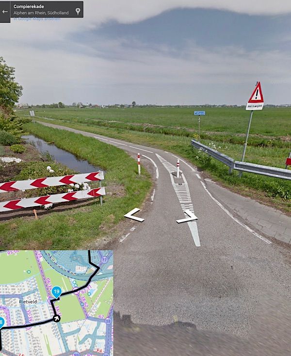
-
Hi Stefan
The link is: https://www.myrouteapp.com/nl/social/route/4604579?mode=shareWhen switching between Open street map (standard) - in this view the route is OK, take close look at the route between route point 18 and 19. 11 and 12 etc.
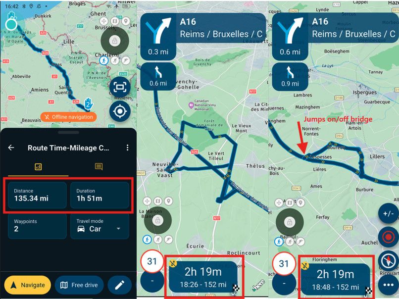
When switching to Here: It messes it up. On the iPhone iOS Navigation app: i believe it selects the Here map as standard? Is there a way to change that to Open street map?@Martin-Middelkoop The behaviour you're seeing is completely expected since the Here map is different from the OpenStreetMap and it is very likely that the bicicyle roads you've been using in the OSM map, are not present in the Here map. This last point can actually be seen:
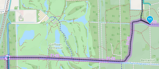
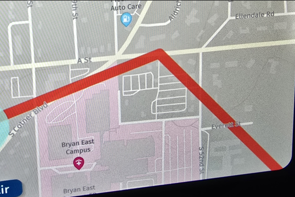
Road between wp11 and wp12 is recognized in the OpenStreetMap.
While in the Here map this road does not exist(disruption in the white road, shown by the Here overlay) and therefore the Here algorithm(used by the Navigation app) goes haywire. In fact it just calculates a route between wp11 and wp12 based on the roads it knows:
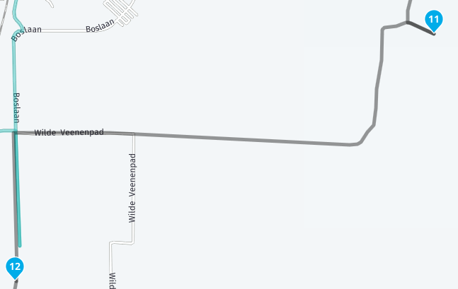
Unfortunately there is no way to change the map algorithm used by MRA Nagation. Not yet. Many people have requested this feature, but it remains to be seen if this will be developed. Maybe in the next roadmap?
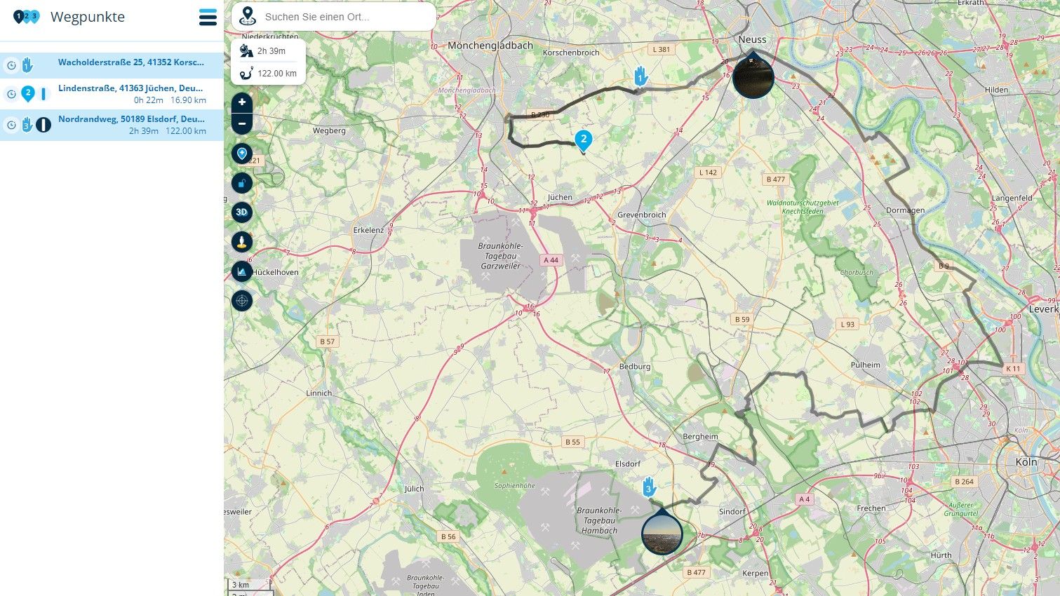
One workaround may be to: create a lot of waypoints at the bicycle roads the Here map does not recognize (use the 'compare with Here' functionality from the toolkit), and set those addedn waypoints to Offroad/Skip. As soon as the MRA Navigation will handle offroad points correctly, you'll see straight lines on your screen between the waypoints but at least you can cycle the road :). For example:
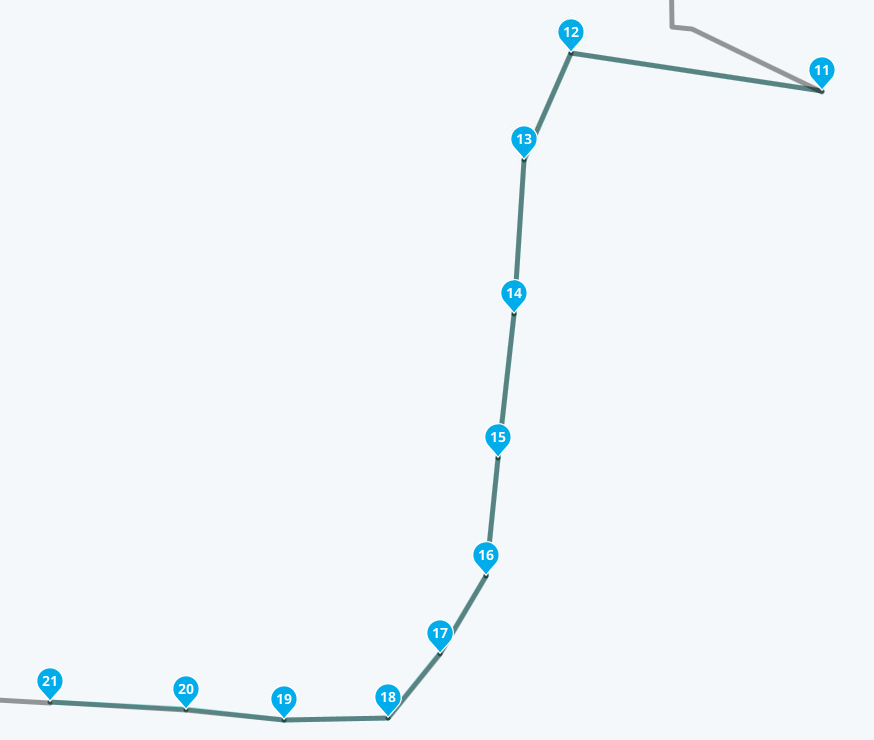
Notice how the green line(Here calculation) now follows the black line(OpenStreetMap calculation) for all the 'Offroad' waypoints (it's underneath the black line very faintly) and how it stops at waypoint 21 because waypoint 22 is not set to 'offroad' -
If I would make the route in Here, it most likely will be identical to the navigation app.
But I would miss all the Bicycle routes. Is there a work around for this?@Martin-Middelkoop The suggestion of Stefan may seem cumbersome, but it actually works. It is very close to the way of working in the early days of navigation, at times when the Garmin etrex was considered a miracle device, even when it could not calculate anything; It could only show on a tiny screen what your position was and where the next waypoint was. It had a massive 24Mb of internal memory.
still, I drove all the way to Italy with that thing (and back, of course) without needing a map.
It is not difficult, it is easy, it's a hobby
-
@Martin-Middelkoop The suggestion of Stefan may seem cumbersome, but it actually works. It is very close to the way of working in the early days of navigation, at times when the Garmin etrex was considered a miracle device, even when it could not calculate anything; It could only show on a tiny screen what your position was and where the next waypoint was. It had a massive 24Mb of internal memory.
still, I drove all the way to Italy with that thing (and back, of course) without needing a map.
@Drabslab @Martin-Middelkoop Although my proposed method works in theory, it does not work yet with MRA navigation since the app cannot distinguish normal waypoints from Offroad waypoints. Therefore routecalculation fails when too many offroad points are used. I made you happy with a dead bug.
My apologies. We'll have to wait for the developers to update the app so that this functionality is included in the navigation app as well.
-
@Drabslab @StefanHummelink Thanks. will wait for that possible update of the Navigation app
Hello! It looks like you're interested in this conversation, but you don't have an account yet.
Getting fed up of having to scroll through the same posts each visit? When you register for an account, you'll always come back to exactly where you were before, and choose to be notified of new replies (either via email, or push notification). You'll also be able to save bookmarks and upvote posts to show your appreciation to other community members.
With your input, this post could be even better 💗
Register Login-
221285
-
0536
-
27110
-
05243
-
734420
-
015
-
017