New update! (4.3.0) Project sync
-
Hi all!

This week, we got a lovely update for MyRoute-app coming your way

A massive shoutout to Joost is well deserved
") He works in the dark to serve the light! And he definitely brings to light to all MRA users with this update. After a lot of technical coding
He works in the dark to serve the light! And he definitely brings to light to all MRA users with this update. After a lot of technical coding  we are proud to present this smashing 4.3.0 update: project Sync!
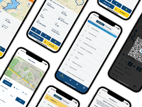
Sync all your routes
Sync? What is sync? According to the oxford dictionary:
in (or out of) sync working well (or badly) together; in (or out of) agreement.
With this update, the app will sync well with the website.
Meaning that all your routes will be magically synced across both platforms

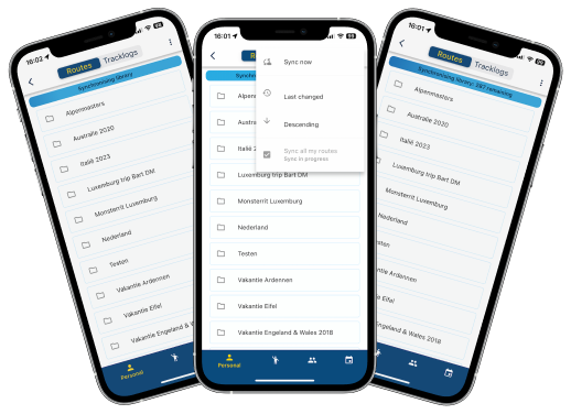
You can sync all your routes or choose an individual route to be synced.
When a route (or all for that matter) is marked as syncable, any changes made to that route in the app, will be uploaded to the website. Or when the route is modified on the website, it will be automatically updated on your phone
By doing so, all your routes will be available in the app all the time and most important of all, they are up to date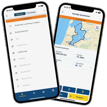
Therefore the downloads folder now no longer contains your own routes.
You also can't download your own routes as you were used to. Just sync them and you are ready to go!
Groups / events / friends are not synced or available offline by default. You will still need to download these yourself and yes, they can be found in your downloads.Conflict handling
What if you made changes in the app and on the website? How do we select the right one to save? We don't! You do

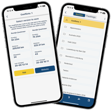
Conflicts are automatically detected and you are forced to resolve these in the app.
Restyling information screen
To facilitate the offline availability of all your routes, the information screen has been modified too!
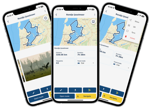
A cleaner look and besides that the following options have been added:
- Share link to route
- Show QR code for easy access
- Mark route to be synced
- Delete
Map styles navigation
This one will make a lot of people very, very happy!
The HERE map lacked some detail. Sad but true

A weird development how all major map suppliers changed their colour scheme to be less rich in contrast.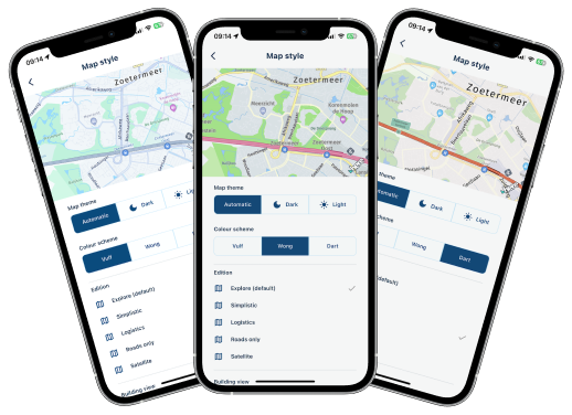
Head over to the map styling section and be amazed! We offer 3 different colour themes and 6 editions! Are you oriented on logistical roads, we got your back!
Want to use the old colour scheme? Try out "Wong" Map configuration
We all enjoy styling / customising the map. More settings have been added!
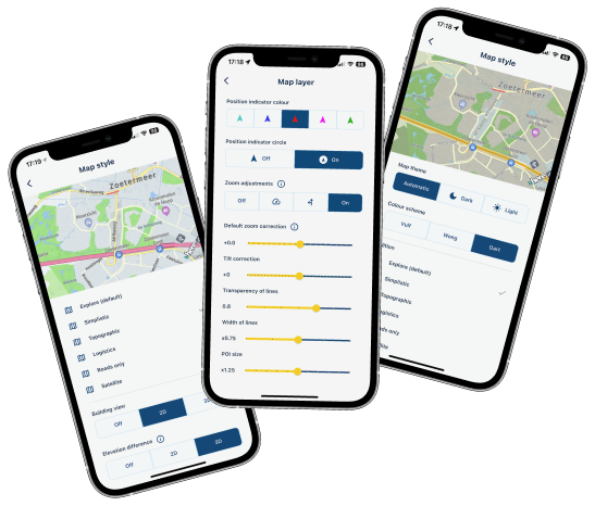
- Allow showing elevation differences in map (only for explore & topographic)
- Change width / opacity of the displayed lines
- Change scaling of POI icons shown on the map
- Larger range of allowed zoom / tilt adjustments
Elevation difference? Is that noticeable?
Oh hell yeah!
(old / 3d / 2d). I mean, just look at it 
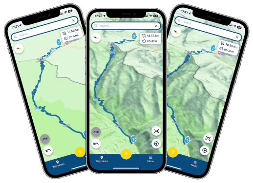
Improvements generated routes
Did you ever generate a nice route? Did you ever want to save / share that? I guess both apply to you but you could never achieve the second

An issue that is no more!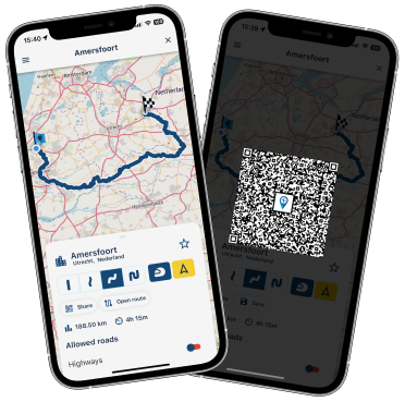
Generate a route and with the touch of a button, you can share the same configuration to your buddy. As this is a QR code, we expect the person that scans it, to be in the same location as you
If not, just save the route! Then you can share the route and it will work too.Minor changes
- Improved Spanish translations thanks to active MRA user Ramon C.L.

- GPX files can be uploaded to MRA simply by opening them with the app
- You can now switch between imperial and metric directly from the app
- Fixed issue where some users could not use the search
- Fixed issue that caused people from Luxemburg to not be able to save their tracklog
- General textual improvements
- Added information popups to complicated settings
- HERE SDK updated to newest version
Wrapup
If this isn't a great update, I don't know what else we can do!
Hopefully you all enjoy this update. After this update we will do another iteration concerning the app stability. Minor new features will also be added such as automatically starting your route at the nearest marker or locking your screenCheers,
Corjan -
Hi all!
This week, we got a lovely update for MyRoute-app coming your way
A massive shoutout to Joost is well deserved
He works in the dark to serve the light! And he definitely brings to light to all MRA users with this update. After a lot of technical coding we are proud to present this smashing 4.3.0 update: project Sync! Sync all your routes
Sync? What is sync? According to the oxford dictionary:
in (or out of) sync working well (or badly) together; in (or out of) agreement.
With this update, the app will sync well with the website.
Meaning that all your routes will be magically synced across both platforms You can sync all your routes or choose an individual route to be synced.
When a route (or all for that matter) is marked as syncable, any changes made to that route in the app, will be uploaded to the website. Or when the route is modified on the website, it will be automatically updated on your phone
By doing so, all your routes will be available in the app all the time and most important of all, they are up to dateTherefore the downloads folder now no longer contains your own routes.
You also can't download your own routes as you were used to. Just sync them and you are ready to go!
Groups / events / friends are not synced or available offline by default. You will still need to download these yourself and yes, they can be found in your downloads.Conflict handling
What if you made changes in the app and on the website? How do we select the right one to save? We don't! You do
Conflicts are automatically detected and you are forced to resolve these in the app.
Restyling information screen
To facilitate the offline availability of all your routes, the information screen has been modified too!
A cleaner look and besides that the following options have been added:
- Share link to route
- Show QR code for easy access
- Mark route to be synced
- Delete
Map styles navigation
This one will make a lot of people very, very happy!
The HERE map lacked some detail. Sad but true
A weird development how all major map suppliers changed their colour scheme to be less rich in contrast.Head over to the map styling section and be amazed! We offer 3 different colour themes and 6 editions! Are you oriented on logistical roads, we got your back!
Want to use the old colour scheme? Try out "Wong" Map configuration
We all enjoy styling / customising the map. More settings have been added!
- Allow showing elevation differences in map (only for explore & topographic)
- Change width / opacity of the displayed lines
- Change scaling of POI icons shown on the map
- Larger range of allowed zoom / tilt adjustments
Elevation difference? Is that noticeable?
Oh hell yeah!
(old / 3d / 2d). I mean, just look at it Improvements generated routes
Did you ever generate a nice route? Did you ever want to save / share that? I guess both apply to you but you could never achieve the second
An issue that is no more!Generate a route and with the touch of a button, you can share the same configuration to your buddy. As this is a QR code, we expect the person that scans it, to be in the same location as you
If not, just save the route! Then you can share the route and it will work too.Minor changes
- Improved Spanish translations thanks to active MRA user Ramon C.L.
- GPX files can be uploaded to MRA simply by opening them with the app
- You can now switch between imperial and metric directly from the app
- Fixed issue where some users could not use the search
- Fixed issue that caused people from Luxemburg to not be able to save their tracklog
- General textual improvements
- Added information popups to complicated settings
- HERE SDK updated to newest version
Wrapup
If this isn't a great update, I don't know what else we can do!
Hopefully you all enjoy this update. After this update we will do another iteration concerning the app stability. Minor new features will also be added such as automatically starting your route at the nearest marker or locking your screenCheers,
Corjan@Corjan-Meijerink thank you for the update on software development.
I am a big fan of both MRA as well as Apple CarPlay, I use Apple Maps for day to day task, but increasingly switching to MRA in the car as well as on my motorcycle (using CHIGEE AIO-5 Play)
I however still have two gripes with the MRA software.
-
One having the ability to freely move the map just to glance further up the route by means of tapping and dragging my finger across the screen like you can with both Apple and Google maps, then tapping n done or re enter to return to my current location, without the need to tap on4 way arrow icon, then tap each an every arrow to move the map just a few centimetres, then the need to tap + or - to zoom in and out, instead of panning with my finger and pinching to zoom in and out the map
-
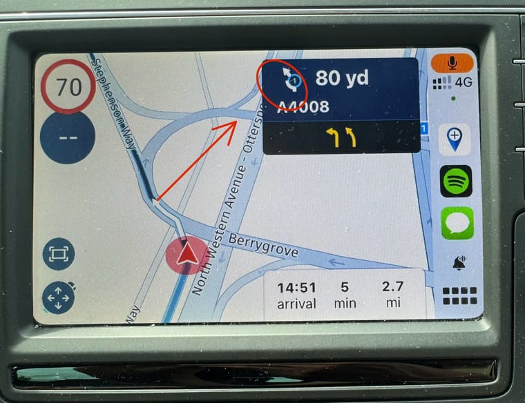
Probably the biggest bugbear. Is the way that roundabout diagram displayed and the exit number shown within. Which is hard to read in a 7” VW screen let alone in a 5” CHIGEE screen. I would sooner have it in written text besides the symbol like Google maps display it for example. The number within the roundabout on CHIGEE device just looks like a pixel from a 2 megapixel camera produced photo in 2003. I simply can’t read it and having to focus on the roundabout layout shown on the map, whilst following the thin blue line on the map, instead of being informed 300-500m before (ps: I don’t do voice guidance) reaching the roundabout, then take an appropriate exit whilst paying attention to the traffic situation around me. I just find it unsafe.
See highlighted image below from a VW Polo.
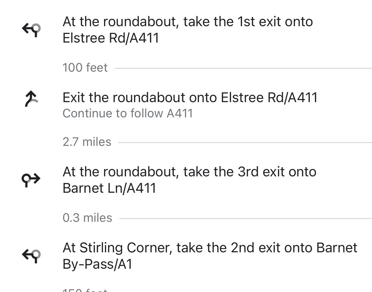
Examples of instructions from Google Maps
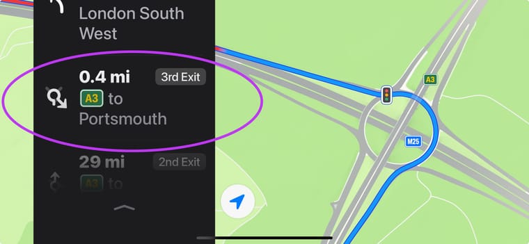
And Apple Maps
Thank you.
-
Hi all!
This week, we got a lovely update for MyRoute-app coming your way
A massive shoutout to Joost is well deserved
He works in the dark to serve the light! And he definitely brings to light to all MRA users with this update. After a lot of technical coding we are proud to present this smashing 4.3.0 update: project Sync! Sync all your routes
Sync? What is sync? According to the oxford dictionary:
in (or out of) sync working well (or badly) together; in (or out of) agreement.
With this update, the app will sync well with the website.
Meaning that all your routes will be magically synced across both platforms You can sync all your routes or choose an individual route to be synced.
When a route (or all for that matter) is marked as syncable, any changes made to that route in the app, will be uploaded to the website. Or when the route is modified on the website, it will be automatically updated on your phone
By doing so, all your routes will be available in the app all the time and most important of all, they are up to dateTherefore the downloads folder now no longer contains your own routes.
You also can't download your own routes as you were used to. Just sync them and you are ready to go!
Groups / events / friends are not synced or available offline by default. You will still need to download these yourself and yes, they can be found in your downloads.Conflict handling
What if you made changes in the app and on the website? How do we select the right one to save? We don't! You do
Conflicts are automatically detected and you are forced to resolve these in the app.
Restyling information screen
To facilitate the offline availability of all your routes, the information screen has been modified too!
A cleaner look and besides that the following options have been added:
- Share link to route
- Show QR code for easy access
- Mark route to be synced
- Delete
Map styles navigation
This one will make a lot of people very, very happy!
The HERE map lacked some detail. Sad but true
A weird development how all major map suppliers changed their colour scheme to be less rich in contrast.Head over to the map styling section and be amazed! We offer 3 different colour themes and 6 editions! Are you oriented on logistical roads, we got your back!
Want to use the old colour scheme? Try out "Wong" Map configuration
We all enjoy styling / customising the map. More settings have been added!
- Allow showing elevation differences in map (only for explore & topographic)
- Change width / opacity of the displayed lines
- Change scaling of POI icons shown on the map
- Larger range of allowed zoom / tilt adjustments
Elevation difference? Is that noticeable?
Oh hell yeah!
(old / 3d / 2d). I mean, just look at it Improvements generated routes
Did you ever generate a nice route? Did you ever want to save / share that? I guess both apply to you but you could never achieve the second
An issue that is no more!Generate a route and with the touch of a button, you can share the same configuration to your buddy. As this is a QR code, we expect the person that scans it, to be in the same location as you
If not, just save the route! Then you can share the route and it will work too.Minor changes
- Improved Spanish translations thanks to active MRA user Ramon C.L.
- GPX files can be uploaded to MRA simply by opening them with the app
- You can now switch between imperial and metric directly from the app
- Fixed issue where some users could not use the search
- Fixed issue that caused people from Luxemburg to not be able to save their tracklog
- General textual improvements
- Added information popups to complicated settings
- HERE SDK updated to newest version
Wrapup
If this isn't a great update, I don't know what else we can do!
Hopefully you all enjoy this update. After this update we will do another iteration concerning the app stability. Minor new features will also be added such as automatically starting your route at the nearest marker or locking your screenCheers,
Corjan@Corjan-Meijerink Great work
 Verry happy with the hard work you all did
 -
This is a really nice one. The devs outdone themselves!
-
Great job by the team. The sync works brilliantly and with such little effort by the user. It just works. Awesome.
-
Great work, the app becomes better and better.
Unfortunately, I hit a definite problem:
https://forum.myrouteapp.com/topic/7752/synchronization-in-the-latest-app-update-a-problem
-
Hi all!
This week, we got a lovely update for MyRoute-app coming your way
A massive shoutout to Joost is well deserved
He works in the dark to serve the light! And he definitely brings to light to all MRA users with this update. After a lot of technical coding we are proud to present this smashing 4.3.0 update: project Sync! Sync all your routes
Sync? What is sync? According to the oxford dictionary:
in (or out of) sync working well (or badly) together; in (or out of) agreement.
With this update, the app will sync well with the website.
Meaning that all your routes will be magically synced across both platforms You can sync all your routes or choose an individual route to be synced.
When a route (or all for that matter) is marked as syncable, any changes made to that route in the app, will be uploaded to the website. Or when the route is modified on the website, it will be automatically updated on your phone
By doing so, all your routes will be available in the app all the time and most important of all, they are up to dateTherefore the downloads folder now no longer contains your own routes.
You also can't download your own routes as you were used to. Just sync them and you are ready to go!
Groups / events / friends are not synced or available offline by default. You will still need to download these yourself and yes, they can be found in your downloads.Conflict handling
What if you made changes in the app and on the website? How do we select the right one to save? We don't! You do
Conflicts are automatically detected and you are forced to resolve these in the app.
Restyling information screen
To facilitate the offline availability of all your routes, the information screen has been modified too!
A cleaner look and besides that the following options have been added:
- Share link to route
- Show QR code for easy access
- Mark route to be synced
- Delete
Map styles navigation
This one will make a lot of people very, very happy!
The HERE map lacked some detail. Sad but true
A weird development how all major map suppliers changed their colour scheme to be less rich in contrast.Head over to the map styling section and be amazed! We offer 3 different colour themes and 6 editions! Are you oriented on logistical roads, we got your back!
Want to use the old colour scheme? Try out "Wong" Map configuration
We all enjoy styling / customising the map. More settings have been added!
- Allow showing elevation differences in map (only for explore & topographic)
- Change width / opacity of the displayed lines
- Change scaling of POI icons shown on the map
- Larger range of allowed zoom / tilt adjustments
Elevation difference? Is that noticeable?
Oh hell yeah!
(old / 3d / 2d). I mean, just look at it Improvements generated routes
Did you ever generate a nice route? Did you ever want to save / share that? I guess both apply to you but you could never achieve the second
An issue that is no more!Generate a route and with the touch of a button, you can share the same configuration to your buddy. As this is a QR code, we expect the person that scans it, to be in the same location as you
If not, just save the route! Then you can share the route and it will work too.Minor changes
- Improved Spanish translations thanks to active MRA user Ramon C.L.
- GPX files can be uploaded to MRA simply by opening them with the app
- You can now switch between imperial and metric directly from the app
- Fixed issue where some users could not use the search
- Fixed issue that caused people from Luxemburg to not be able to save their tracklog
- General textual improvements
- Added information popups to complicated settings
- HERE SDK updated to newest version
Wrapup
If this isn't a great update, I don't know what else we can do!
Hopefully you all enjoy this update. After this update we will do another iteration concerning the app stability. Minor new features will also be added such as automatically starting your route at the nearest marker or locking your screenCheers,
Corjan@Corjan-Meijerink
Wow, that sounds really good. Update wasn't available yesterday evening here in Germany, but now it is. Phone is already downloadingGreetings
Thomas -
Really great new functions. Also the different views for the maps. Now you can finally see the roads well with Here Map. The synchronisation is also great, but it would be an advantage if you could apply it to individual folders. I also have a lot of routes online, synchronising them all would be too much of a good thing
-
Really great new functions. Also the different views for the maps. Now you can finally see the roads well with Here Map. The synchronisation is also great, but it would be an advantage if you could apply it to individual folders. I also have a lot of routes online, synchronising them all would be too much of a good thing
@Parantapa said in New update! (4.3.0) Project sync:
synchronising them all would be too much of a good thing
Just try it! It will only take 2 minutes or so, and after that, ONLY changes to existing routes, and new routes are synced!
-
 undefined Rob Verhoeff referenced this topic on
-
Hi,
I am a big fan of MRA, both for the web and the app, I think the team does an amazing job.
Today I noticed that with the new app version 4.3, the width of the lines was not reflected on Carplay: I was using both the app and carplay at the same time, and on the app the lines were wide (as I set the width line parameter to x1.25) but on Carplay they were thin, just as before the update.
Is this a Carplay limitation or is this not implemented on Carplay version yet ?
Ron
iPhone 15 with iOS 17.6.1
Carplay on BMW 430i
Carplay on Innovv N1 Pro (moto)BMW 1250 RS '23
Garmin Zumo XT2 (sold)
Chigee AIO-5 Lite (sold)
Innovv N1 Pro (sold)
Chigee AIO-6 MAX -
Hi,
I am a big fan of MRA, both for the web and the app, I think the team does an amazing job.
Today I noticed that with the new app version 4.3, the width of the lines was not reflected on Carplay: I was using both the app and carplay at the same time, and on the app the lines were wide (as I set the width line parameter to x1.25) but on Carplay they were thin, just as before the update.
Is this a Carplay limitation or is this not implemented on Carplay version yet ?
Ron
iPhone 15 with iOS 17.6.1
Carplay on BMW 430i
Carplay on Innovv N1 Pro (moto)@Ronny-Schenkels-0 Should work on CarPlay!
Maybe it did not synchronise immediately. Probably it will work as expected when reconnecting to CarPlay again.Thanks for the kind words
-
@Ronny-Schenkels-0 Should work on CarPlay!
Maybe it did not synchronise immediately. Probably it will work as expected when reconnecting to CarPlay again.Thanks for the kind words
You automatically get a route from a foreign group whose member you are also synchronized with your own mobile phone so that it is also immediately available offline ...
Currently, this does not seem to be offered:
Two steps:
-
Open route in group
-
Download Route
-
Route then first start
If no net and that happens in the mountains what is then?
-
App was accidentally stopped during a break
-
Route from download load / Start ?? Would be cumbersome
For security for users in the group:
- Do I really have to go cumbersomely through the route lab in the morning and "use" the route means copying ... so it is then synchronized for offline????
We had the problems somehow in Slovenia.
VG
VG Hubert
Beta Test "Next App" dazu die Hardware .
iPad 9. Gen iOS 26.5.2/ iPhone 16e iOS 26.5.2/ Navi iPhone Xr iOS 18.7.9 / PC mit MS Win11 /❗️MyRoute-App im Cradel und Remotek-One❗️ Info zu MRA & Remotek One -
-
You automatically get a route from a foreign group whose member you are also synchronized with your own mobile phone so that it is also immediately available offline ...
Currently, this does not seem to be offered:
Two steps:
-
Open route in group
-
Download Route
-
Route then first start
If no net and that happens in the mountains what is then?
-
App was accidentally stopped during a break
-
Route from download load / Start ?? Would be cumbersome
For security for users in the group:
- Do I really have to go cumbersomely through the route lab in the morning and "use" the route means copying ... so it is then synchronized for offline????
We had the problems somehow in Slovenia.
VG
@Hubert-Thoring said in New update! (4.3.0) Project sync:
If no net and that happens in the mountains what is then?
If you go drive routes that are not in your own library, you need to add them to your downloads, just like with your own routes before the sync update. You can then start those routes from the downloads folder, just like it always was.
Do I really have to go cumbersomely through the route lab in the morning and "use" the route means copying ... so it is then synchronized for offline????
No, just add them to your downloads.
-
-
@Corjan-Meijerink In the app you can now easily switch between your private routes/tracks and the routes/tracks of Friends, Groups and Events. What I don’t like is that when you switch from routes to track or the other way around, you always go back to your private routes/tracks. For me it would be more logical if you can switch between routes/tracks in the same folder (Private, Froends, Groups or Events).
-
This update is really awesome, great job done!
The new map styles and configurations look especially good, but sometimes I'd like to use the OSM map layer for planning. Are there any schedules for including the existing layers (OSM, TomTom, etc.) in the planner as well?
-
This update is really awesome, great job done!
The new map styles and configurations look especially good, but sometimes I'd like to use the OSM map layer for planning. Are there any schedules for including the existing layers (OSM, TomTom, etc.) in the planner as well?
@Martin-Wilcke Those are not expected
Thanks for the kind words! -
@Martin-Wilcke Those are not expected
Thanks for the kind words!@Corjan-Meijerink
Are there any particular reasons for different map sets for browsing and planning? Or will the app finally end up with HERE maps only? -
@Corjan-Meijerink
Are there any particular reasons for different map sets for browsing and planning? Or will the app finally end up with HERE maps only?@Martin-Wilcke the OSM and TomTom map are available in the web module (Gold abo only) but in the end for navigating you must convert such a route to the Here map because Next uses Here and Here only
Honda Goldwing GL1500,
Honda Silverwing GL 650
DMD2 T865X 8 inch Android tablet using MRA next for navigation
Garmin XT sold
Samsung S24FE mounted on a Quadlock and using Android Auto in my car -
@Martin-Wilcke the OSM and TomTom map are available in the web module (Gold abo only) but in the end for navigating you must convert such a route to the Here map because Next uses Here and Here only
@Marinus-van-Deudekom
Yes, I know. However, my question is not about different routing engines but about different map layers. -
 undefined Brian McG referenced this topic on
-
@Peter-Schiefer
Agreed.
But to clarify: I'm not comparing the web planner with the app planner. It's about the different map layer sets within the app.
Several map layers are available in "browse/view" mode, including OSM, HERE and TomTom.
In "edit/planning" mode ("MRA Routeplanner"), however, we have one map layer (HERE) with various style options: Vulf, Wong, Dart and a bunch of "edition" options (explore, topo, satellite, etc.)
I'd like to know if this will be harmonised and, if so, in which way.
Hello! It looks like you're interested in this conversation, but you don't have an account yet.
Getting fed up of having to scroll through the same posts each visit? When you register for an account, you'll always come back to exactly where you were before, and choose to be notified of new replies (either via email, or push notification). You'll also be able to save bookmarks and upvote posts to show your appreciation to other community members.
With your input, this post could be even better 💗
Register Login-
017188
-
011187
-
011207
-
7382.5k
-
012511
-
617366
-
0210
-
0594
