
New MRA Mobile Update 3.2.0
-

Version 3.2.0 out now!
Today we launched another big update for the MyRoute-app Mobile app! In version 3.2.0 the following changes have been made:
- Say goodbye to low resolution raster (Image) maplayers. MyRoute-app Mobile now supports the use of Vector maps enabling a truly immersive experience with 3D rendering
- Waypoints now show the selected pause icon. When a note or images have been added to the waypoint you can display these by tapping on the waypoint
- Support for the new My Triumph app
- Improved tracking
Vector maps truly enable an immersive experience while using the app! These premium maps match what you expect from us with an app that is constantly improving.
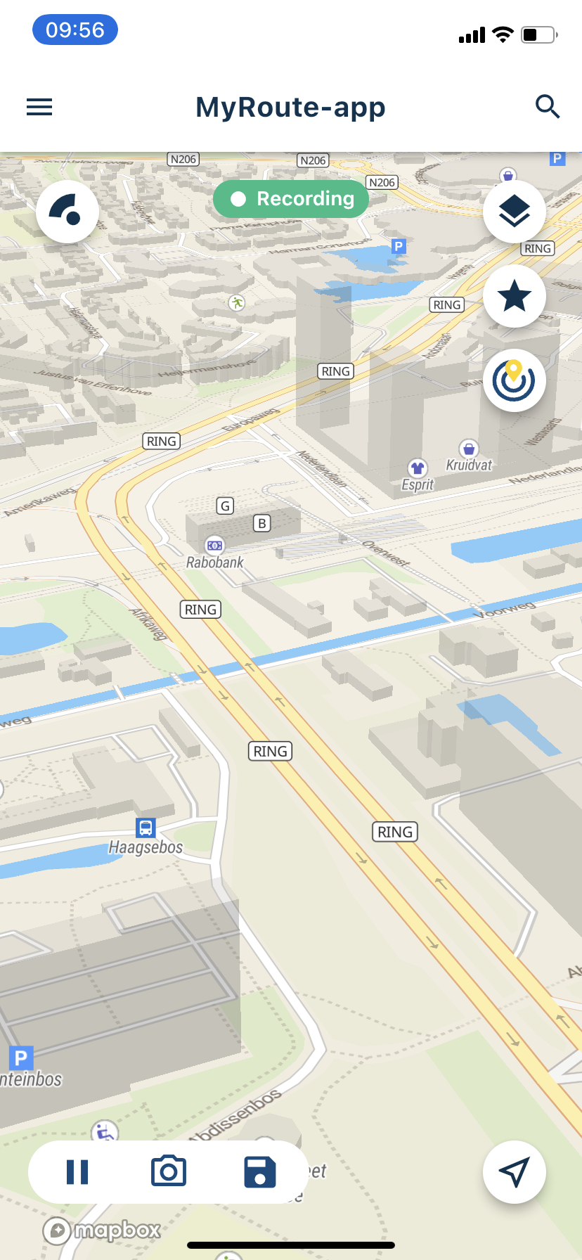
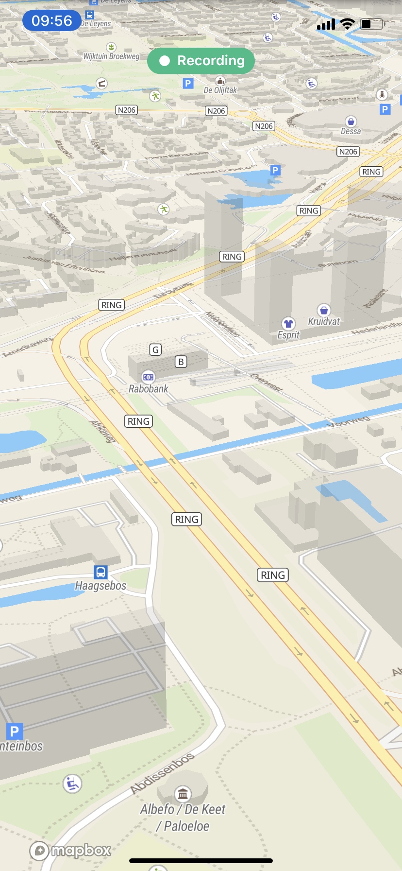
As we want to lay more emphasis on these maps, you can now even see more map than ever before! With a single tap on the screen, the buttons hide (as already existed in the app) but now we also hide the top bar. By doing so, you can truly focus on the road and the route you are driving.
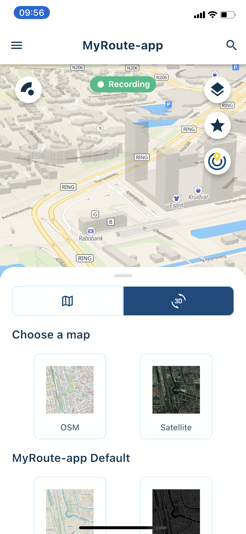
You can obviously still switch between the old and new maps. Do so by changing maplayers and selecting the other menu item. The OSM vector map is available to all users. I would personally recommend purchasing a Silver subscription as the MyRoute-app Streets vector map is absolutely stunning. This is the only visible in the screenshots above. All other vector maps require a minimum Silver subscription. The HERE / TomTom vector maps are for Gold only users.
In another recent update, we introduced the nearby routes feature! With the click of a button you can view the routes created by our RouteXperts that are within your vicinity. Did you know that coloured waypoints actually mean something?
Blue = standard point for shaping your route
Yellow = nice point what you can see on your route but don’t stop.
Green = Nice point to take a picture or nice view
Red = stop for koffie, lunch, petrol or hotel
Pink = extra info for example ferry or warning for bad road surfaceIf you click on a waypoint containing extra information, you will be able to read the info! As a nice little extra, you will also see the selected icon next to the waypoint. Just like in the website.
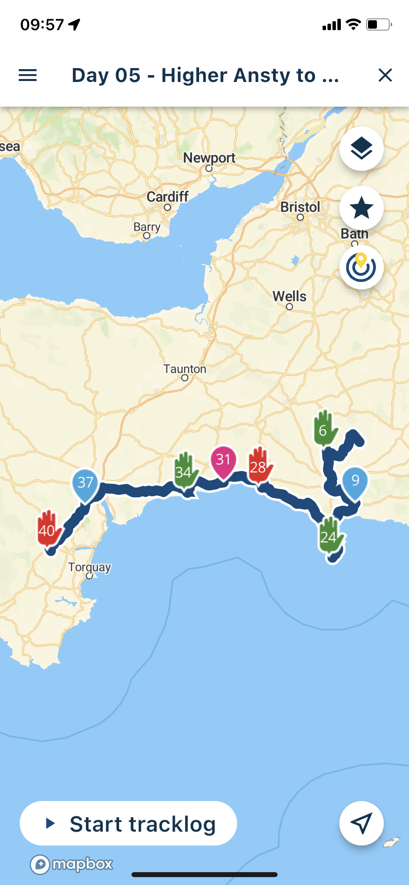
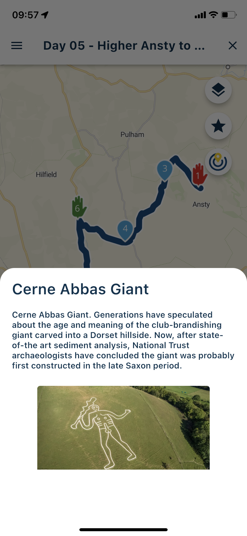
Waypoints in the app now don't overlap with each other. Zoom in to see other waypoints that might not be displayed at you current zoom level.
All these changes bring the Mobile app more in sync with the website allowing our users to use the app more and more to their satisfaction!
We also solved a minor nuisance in the app. When driving a route / track or simply free driving. We now pre-fill the name of the tracklog with the opened route / track or the current date. Less typing for you, and way easier to find you tracklogs again!

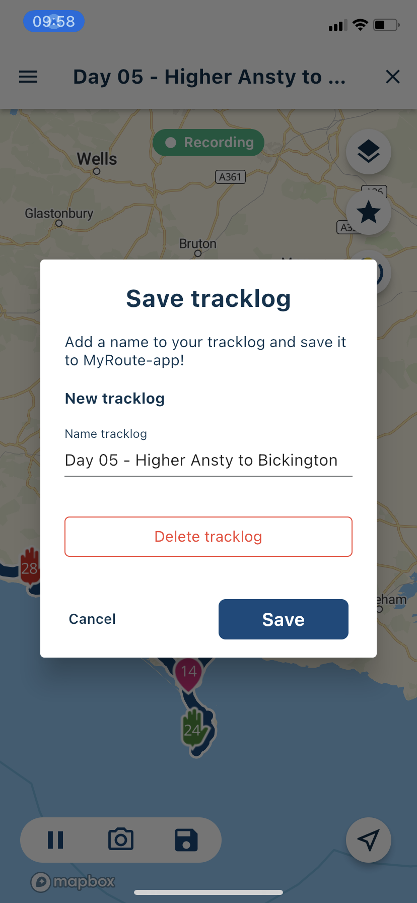
That was it for this update! We are currently working on update 3.2.1 which will add some more amazing features! Keep posted for more.
Cheers,
Corjan
Team MyRoute-app -
Corjan Meijerink pinned this topic on
-
Version 3.2.0 out now!
Today we launched another big update for the MyRoute-app Mobile app! In version 3.2.0 the following changes have been made:
- Say goodbye to low resolution raster (Image) maplayers. MyRoute-app Mobile now supports the use of Vector maps enabling a truly immersive experience with 3D rendering
- Waypoints now show the selected pause icon. When a note or images have been added to the waypoint you can display these by tapping on the waypoint
- Support for the new My Triumph app
- Improved tracking
Vector maps truly enable an immersive experience while using the app! These premium maps match what you expect from us with an app that is constantly improving.
As we want to lay more emphasis on these maps, you can now even see more map than ever before! With a single tap on the screen, the buttons hide (as already existed in the app) but now we also hide the top bar. By doing so, you can truly focus on the road and the route you are driving.
You can obviously still switch between the old and new maps. Do so by changing maplayers and selecting the other menu item. The OSM vector map is available to all users. I would personally recommend purchasing a Silver subscription as the MyRoute-app Streets vector map is absolutely stunning. This is the only visible in the screenshots above. All other vector maps require a minimum Silver subscription. The HERE / TomTom vector maps are for Gold only users.
In another recent update, we introduced the nearby routes feature! With the click of a button you can view the routes created by our RouteXperts that are within your vicinity. Did you know that coloured waypoints actually mean something?
Blue = standard point for shaping your route
Yellow = nice point what you can see on your route but don’t stop.
Green = Nice point to take a picture or nice view
Red = stop for koffie, lunch, petrol or hotel
Pink = extra info for example ferry or warning for bad road surfaceIf you click on a waypoint containing extra information, you will be able to read the info! As a nice little extra, you will also see the selected icon next to the waypoint. Just like in the website.
Waypoints in the app now don't overlap with each other. Zoom in to see other waypoints that might not be displayed at you current zoom level.
All these changes bring the Mobile app more in sync with the website allowing our users to use the app more and more to their satisfaction!
We also solved a minor nuisance in the app. When driving a route / track or simply free driving. We now pre-fill the name of the tracklog with the opened route / track or the current date. Less typing for you, and way easier to find you tracklogs again!
That was it for this update! We are currently working on update 3.2.1 which will add some more amazing features! Keep posted for more.
Cheers,
Corjan
Team MyRoute-app
@Corjan-Meijerink The new vector maps are excellent, I especially like the Here map for navigation.
I’m currently testing it now. Breakfast stop at The Engine Room on the A39 at Otterham Station. Superb update @Corjan-Meijerink

-
Version 3.2.0 out now!
Today we launched another big update for the MyRoute-app Mobile app! In version 3.2.0 the following changes have been made:
- Say goodbye to low resolution raster (Image) maplayers. MyRoute-app Mobile now supports the use of Vector maps enabling a truly immersive experience with 3D rendering
- Waypoints now show the selected pause icon. When a note or images have been added to the waypoint you can display these by tapping on the waypoint
- Support for the new My Triumph app
- Improved tracking
Vector maps truly enable an immersive experience while using the app! These premium maps match what you expect from us with an app that is constantly improving.
As we want to lay more emphasis on these maps, you can now even see more map than ever before! With a single tap on the screen, the buttons hide (as already existed in the app) but now we also hide the top bar. By doing so, you can truly focus on the road and the route you are driving.
You can obviously still switch between the old and new maps. Do so by changing maplayers and selecting the other menu item. The OSM vector map is available to all users. I would personally recommend purchasing a Silver subscription as the MyRoute-app Streets vector map is absolutely stunning. This is the only visible in the screenshots above. All other vector maps require a minimum Silver subscription. The HERE / TomTom vector maps are for Gold only users.
In another recent update, we introduced the nearby routes feature! With the click of a button you can view the routes created by our RouteXperts that are within your vicinity. Did you know that coloured waypoints actually mean something?
Blue = standard point for shaping your route
Yellow = nice point what you can see on your route but don’t stop.
Green = Nice point to take a picture or nice view
Red = stop for koffie, lunch, petrol or hotel
Pink = extra info for example ferry or warning for bad road surfaceIf you click on a waypoint containing extra information, you will be able to read the info! As a nice little extra, you will also see the selected icon next to the waypoint. Just like in the website.
Waypoints in the app now don't overlap with each other. Zoom in to see other waypoints that might not be displayed at you current zoom level.
All these changes bring the Mobile app more in sync with the website allowing our users to use the app more and more to their satisfaction!
We also solved a minor nuisance in the app. When driving a route / track or simply free driving. We now pre-fill the name of the tracklog with the opened route / track or the current date. Less typing for you, and way easier to find you tracklogs again!
That was it for this update! We are currently working on update 3.2.1 which will add some more amazing features! Keep posted for more.
Cheers,
Corjan
Team MyRoute-app
@Corjan-Meijerink Wow, simply amazed by the rate of improvement for this app! I can't wait to see the same kind of development taking place in the navigation app! @Corjan-Meijerink, you have created a lot of expectations dude!

Keep us posted regarding that Nav app.
-
Version 3.2.0 out now!
Today we launched another big update for the MyRoute-app Mobile app! In version 3.2.0 the following changes have been made:
- Say goodbye to low resolution raster (Image) maplayers. MyRoute-app Mobile now supports the use of Vector maps enabling a truly immersive experience with 3D rendering
- Waypoints now show the selected pause icon. When a note or images have been added to the waypoint you can display these by tapping on the waypoint
- Support for the new My Triumph app
- Improved tracking
Vector maps truly enable an immersive experience while using the app! These premium maps match what you expect from us with an app that is constantly improving.
As we want to lay more emphasis on these maps, you can now even see more map than ever before! With a single tap on the screen, the buttons hide (as already existed in the app) but now we also hide the top bar. By doing so, you can truly focus on the road and the route you are driving.
You can obviously still switch between the old and new maps. Do so by changing maplayers and selecting the other menu item. The OSM vector map is available to all users. I would personally recommend purchasing a Silver subscription as the MyRoute-app Streets vector map is absolutely stunning. This is the only visible in the screenshots above. All other vector maps require a minimum Silver subscription. The HERE / TomTom vector maps are for Gold only users.
In another recent update, we introduced the nearby routes feature! With the click of a button you can view the routes created by our RouteXperts that are within your vicinity. Did you know that coloured waypoints actually mean something?
Blue = standard point for shaping your route
Yellow = nice point what you can see on your route but don’t stop.
Green = Nice point to take a picture or nice view
Red = stop for koffie, lunch, petrol or hotel
Pink = extra info for example ferry or warning for bad road surfaceIf you click on a waypoint containing extra information, you will be able to read the info! As a nice little extra, you will also see the selected icon next to the waypoint. Just like in the website.
Waypoints in the app now don't overlap with each other. Zoom in to see other waypoints that might not be displayed at you current zoom level.
All these changes bring the Mobile app more in sync with the website allowing our users to use the app more and more to their satisfaction!
We also solved a minor nuisance in the app. When driving a route / track or simply free driving. We now pre-fill the name of the tracklog with the opened route / track or the current date. Less typing for you, and way easier to find you tracklogs again!
That was it for this update! We are currently working on update 3.2.1 which will add some more amazing features! Keep posted for more.
Cheers,
Corjan
Team MyRoute-app
@Corjan-Meijerink simply beautiful

-
Corjan Meijerink referenced this topic on
-

Yes the map is beautiful but for me it is still a flat 2D map, despite choosing a 3D map in the layer menu. How do I give it an angle?
I am just an enthusiastic MRA user, and hope you will be one too!
Most motorcycle problems are caused by the nut that connects the handlebar to the saddle.
Check out RideSleepRepeat.eu, a biker community for sharing stays across Europe
-
Yes the map is beautiful but for me it is still a flat 2D map, despite choosing a 3D map in the layer menu. How do I give it an angle?
@Con-Hennekens Actually not all vector maps render everything in 3D. The vector maps MyRoute-app Street and the HERE do. The others don't at all or not in all regions.
If you select one of the above maps and go into 'Navigate' mode (tap the location icon bottom right twice) the map will tilt for you.
You can also tilt yourself by dragging two fingers next to each other in up / down direction over the screen. (is that clear? Something like this hahaha https://www.nextpit.com/forum/561686/how-to-use-google-maps-secret-gestures)Edit: the main advantage that all vector maps do have is that they are incredibly sharp on all zoom levels and the labels on the map rotate in perspective to the map. When using raster tiles (the old maps) you would often see place names upside down when rotating the map
-

Looks great! I use the mobile-app for bicycle navigation. Works fine, thnx

-
@Con-Hennekens Actually not all vector maps render everything in 3D. The vector maps MyRoute-app Street and the HERE do. The others don't at all or not in all regions.
If you select one of the above maps and go into 'Navigate' mode (tap the location icon bottom right twice) the map will tilt for you.
You can also tilt yourself by dragging two fingers next to each other in up / down direction over the screen. (is that clear? Something like this hahaha https://www.nextpit.com/forum/561686/how-to-use-google-maps-secret-gestures)Edit: the main advantage that all vector maps do have is that they are incredibly sharp on all zoom levels and the labels on the map rotate in perspective to the map. When using raster tiles (the old maps) you would often see place names upside down when rotating the map
@Corjan-Meijerink, ah! The arrow button did the trick, thanks!
-

@Corjan-Meijerink said in New MRA Mobile Update 3.2.0:
Support for the new My Triumph app
In what way? Are you saying you create your route in MRA and can send it to the Triumph App?
-
@Corjan-Meijerink said in New MRA Mobile Update 3.2.0:
Support for the new My Triumph app
In what way? Are you saying you create your route in MRA and can send it to the Triumph App?
@Terry-Cox-0
Hi Terry,There has been an update to the Triumph App that can now import GPX files so yes Plan in MRA and Export the GPX File and then Import the GPX file to the Triumph App.
-
@Corjan-Meijerink Wow, simply amazed by the rate of improvement for this app! I can't wait to see the same kind of development taking place in the navigation app! @Corjan-Meijerink, you have created a lot of expectations dude!
Keep us posted regarding that Nav app.
Great
but Yes, bring it to Navigation and include a possibility for audiosignal ( by choise) for each waypoint. You can't expect trafficers to look at their navigation all the time. -
This post is deleted!
-
What exactly is the support for My Triumph? I can’t find any reference to it anywhere, including in ‘support’.
I have managed to download a gpx file from MRA directly to my phone (didn’t work on OneDrive for some reason) and then imported it into the My Triumph app.
A slicker direct connection between MRA and My Triumph app would be great, especially if possible to use MRA full navigation as well, although I guess that will be dependent upon Triumph instead of MRA?
-
What exactly is the support for My Triumph? I can’t find any reference to it anywhere, including in ‘support’.
I have managed to download a gpx file from MRA directly to my phone (didn’t work on OneDrive for some reason) and then imported it into the My Triumph app.
A slicker direct connection between MRA and My Triumph app would be great, especially if possible to use MRA full navigation as well, although I guess that will be dependent upon Triumph instead of MRA?
@Martin-Field It is in Dutch but we had a small chat about it here: https://forum.myrouteapp.com/topic/1955/hallo-weet-er-iemand-of-mra-werkt-met-de-navigatie-van-triumph-tiger-pro-dank-je
I will create a blog next week talking about this!
-
Corjan Meijerink unpinned this topic on
-
Version 3.2.0 out now!
Today we launched another big update for the MyRoute-app Mobile app! In version 3.2.0 the following changes have been made:
- Say goodbye to low resolution raster (Image) maplayers. MyRoute-app Mobile now supports the use of Vector maps enabling a truly immersive experience with 3D rendering
- Waypoints now show the selected pause icon. When a note or images have been added to the waypoint you can display these by tapping on the waypoint
- Support for the new My Triumph app
- Improved tracking
Vector maps truly enable an immersive experience while using the app! These premium maps match what you expect from us with an app that is constantly improving.
As we want to lay more emphasis on these maps, you can now even see more map than ever before! With a single tap on the screen, the buttons hide (as already existed in the app) but now we also hide the top bar. By doing so, you can truly focus on the road and the route you are driving.
You can obviously still switch between the old and new maps. Do so by changing maplayers and selecting the other menu item. The OSM vector map is available to all users. I would personally recommend purchasing a Silver subscription as the MyRoute-app Streets vector map is absolutely stunning. This is the only visible in the screenshots above. All other vector maps require a minimum Silver subscription. The HERE / TomTom vector maps are for Gold only users.
In another recent update, we introduced the nearby routes feature! With the click of a button you can view the routes created by our RouteXperts that are within your vicinity. Did you know that coloured waypoints actually mean something?
Blue = standard point for shaping your route
Yellow = nice point what you can see on your route but don’t stop.
Green = Nice point to take a picture or nice view
Red = stop for koffie, lunch, petrol or hotel
Pink = extra info for example ferry or warning for bad road surfaceIf you click on a waypoint containing extra information, you will be able to read the info! As a nice little extra, you will also see the selected icon next to the waypoint. Just like in the website.
Waypoints in the app now don't overlap with each other. Zoom in to see other waypoints that might not be displayed at you current zoom level.
All these changes bring the Mobile app more in sync with the website allowing our users to use the app more and more to their satisfaction!
We also solved a minor nuisance in the app. When driving a route / track or simply free driving. We now pre-fill the name of the tracklog with the opened route / track or the current date. Less typing for you, and way easier to find you tracklogs again!
That was it for this update! We are currently working on update 3.2.1 which will add some more amazing features! Keep posted for more.
Cheers,
Corjan
Team MyRoute-app
@Corjan-Meijerink said in New MRA Mobile Update 3.2.0:
Support for the new My Triumph app
What exactly does it mean?
-
@Corjan-Meijerink said in New MRA Mobile Update 3.2.0:
Support for the new My Triumph app
What exactly does it mean?
@Vlad-Popovici-0 That gpx files can be shared with the My Triumph app enabling turn-by-turn navigation on your Triumph bike
Hello! It looks like you're interested in this conversation, but you don't have an account yet.
Getting fed up of having to scroll through the same posts each visit? When you register for an account, you'll always come back to exactly where you were before, and choose to be notified of new replies (either via email, or push notification). You'll also be able to save bookmarks and upvote posts to show your appreciation to other community members.
With your input, this post could be even better 💗
Register Login-
 0745
0745
-
 1514
1514
-
0524
-
06260
-
 06237
06237
-
04137
-
 17214
17214
-
0359