Show elevation
-
I have been using the planner for quite some time in combination with a Garmin navigator, now I am starting to use the app. One thing I miss compared to the navigator is having the elevation on the screen. Agreed, it's not essential and probably not an issue in the Netherlands
") , but I miss not seeing the elevation as I ride from pass to pass in the Alps. Thanks for your attention!
, but I miss not seeing the elevation as I ride from pass to pass in the Alps. Thanks for your attention! -
I have been using the planner for quite some time in combination with a Garmin navigator, now I am starting to use the app. One thing I miss compared to the navigator is having the elevation on the screen. Agreed, it's not essential and probably not an issue in the Netherlands
, but I miss not seeing the elevation as I ride from pass to pass in the Alps. Thanks for your attention!@Graziano-0, I( would welcome that to. The Garmin way of choosing your own data fields is quite clever.
-
I have been using the planner for quite some time in combination with a Garmin navigator, now I am starting to use the app. One thing I miss compared to the navigator is having the elevation on the screen. Agreed, it's not essential and probably not an issue in the Netherlands
, but I miss not seeing the elevation as I ride from pass to pass in the Alps. Thanks for your attention!@Graziano-0 if it is part of a selectable menu, it sounds intriguing...if not, in my opinion (I'm sure everyone has a view
 ) the screen is busy enough. I'd prefer lareger roadway/POI icons - at least a size that is recognizable from the current very small, mostly indiscernable ones.
 -
@Graziano-0 May be this helps until it is implemented.
Hardware
iPhone 12 pro (iOS 26.2.1)
iPad (7.Gen.) 18.7.3
Oukitel RT3 Pro (Andr. 14)
Wireless CarPlay mit (Elebest C650)
Wired CarPlay (SEAT Arona - 2021)
MRA Workshops in Deutsch sind hier zu finden -
@Graziano-0 May be this helps until it is implemented.
@Jörgen Thank you, but it seems I have no access to that link
-
@Jörgen Thank you, but it seems I have no access to that link
@Graziano-0 @Jörgen was referencing a post from the closed BETA forum, this is why you don’t have access from the link. Jörgen has found an app that works for Android phones and it will add an altimeter to your maps, including MRA. You can find it in the PlayStore and it’s called: Maps Altimeter
Always willing to help if I can.
Triumph Tiger 1200 XRT called Tina.
MRA Navigation Next and SilverFox BJ8 -
@Graziano-0 @Jörgen was referencing a post from the closed BETA forum, this is why you don’t have access from the link. Jörgen has found an app that works for Android phones and it will add an altimeter to your maps, including MRA. You can find it in the PlayStore and it’s called: Maps Altimeter
@Nick-Carthew Thanks! I did not know that app, it looks to be very nice, to be seen how it works while riding (ie elevation continuosly changing), but if it works it's a very good option.
-
@Graziano-0 @Jörgen was referencing a post from the closed BETA forum, this is why you don’t have access from the link. Jörgen has found an app that works for Android phones and it will add an altimeter to your maps, including MRA. You can find it in the PlayStore and it’s called: Maps Altimeter
@Nick-Carthew Thank you Nick.
Yes this App will help until there is something in MRA.
I made it look like it is in MRA, the setup makes it possible.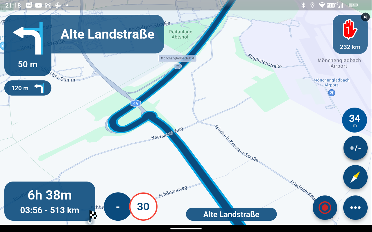
-
I too miss this option. Temperature changes linked to elevation variations are usually significant, and I like to have that information at hand. When riding mountain roads, changes in elevation are pretty obvious, but quite often it's hard to tell when riding through plateaus. I am using MyrouteApp + Carplay, so Jörgen's suggestion is not an option for me and I would appreciate the team to have this suggestion into consideration.
Thanks,
-
@Peter-Schiefer Thank you for your insight.
Personally, I see plenty of room to implement the requested feature either on the right side or at the bottom:

But even if it is not possible to add a new info widget for whichever the reasons, I would personally trade one of the current info widgets. For instance, showing the Estimated Time of Arrival AND the remaining time, at the same time, is redundant in my opinion. I would gladly swap one of those for the elevation (or any other at the choice of the user).
I too used a Garmin sat navigation device for years and I loved being able to choose which info blocks to have available. And elevation was definitely always on for me. I really cannot see why MyRoute-app cannot, or should not, offer the user the possibility to choose among the options most useful for each user.
I understand that this may not be a very popular request. But, being a "suggestion forum", I believe I am entitled to make mine. If fact, I am just supporting another user's request.
Thank you for your time.
Regards,
-
@Peter-Schiefer Thank you for your insight.
Personally, I see plenty of room to implement the requested feature either on the right side or at the bottom:
But even if it is not possible to add a new info widget for whichever the reasons, I would personally trade one of the current info widgets. For instance, showing the Estimated Time of Arrival AND the remaining time, at the same time, is redundant in my opinion. I would gladly swap one of those for the elevation (or any other at the choice of the user).
I too used a Garmin sat navigation device for years and I loved being able to choose which info blocks to have available. And elevation was definitely always on for me. I really cannot see why MyRoute-app cannot, or should not, offer the user the possibility to choose among the options most useful for each user.
I understand that this may not be a very popular request. But, being a "suggestion forum", I believe I am entitled to make mine. If fact, I am just supporting another user's request.
Thank you for your time.
Regards,
@Ramon-Cutanda-Lopez having a menu of options to choose from would be ideal.
-
@Peter-Schiefer Thank you for your insight.
Personally, I see plenty of room to implement the requested feature either on the right side or at the bottom:
But even if it is not possible to add a new info widget for whichever the reasons, I would personally trade one of the current info widgets. For instance, showing the Estimated Time of Arrival AND the remaining time, at the same time, is redundant in my opinion. I would gladly swap one of those for the elevation (or any other at the choice of the user).
I too used a Garmin sat navigation device for years and I loved being able to choose which info blocks to have available. And elevation was definitely always on for me. I really cannot see why MyRoute-app cannot, or should not, offer the user the possibility to choose among the options most useful for each user.
I understand that this may not be a very popular request. But, being a "suggestion forum", I believe I am entitled to make mine. If fact, I am just supporting another user's request.
Thank you for your time.
Regards,
@Ramon-Cutanda-Lopez That is the old app
Not that the new app supports the elevation to be displayed but you should stop using that app")
-
@Ramon-Cutanda-Lopez That is the old app
Not that the new app supports the elevation to be displayed but you should stop using that appThank you Peter and Corjan. When I wrote this post I was away from my device and, just for illustration purposes, the screen capture I used was actually one taken from the YouTube channel: https://www.youtube.com/watch?v=QMCG76K3F0g
I had once access to the betas, but lost it at some point. I was not using the Navigation app because its lack of loading routes directly from Carplay. I am currently using 4.2.0, but now that MRA is finally my main navigation app I will ask access to the beta again to test any new features.
Regards,


-
Just like to chip and agree that I would also like to be able to see elevation while riding. I am using the app directly, not via CarPlay. I'll give the app mentioned above a go, but I'd love to have it in the MRA app as well.