STILL having issues w/ my Zumo XT not following the route
-
I am still having issues with my Zumo XT NOT following the route designed in MRA completely/correctly. I have added a bunch more shaping points, used the export to 1.2 gpx. It didn't take long before it routed me down a DEAD END ROAD.... I knew the area and just drove by it. I then took another road, thus passing a WAYPOINT. I "skipped" the waypoint via Zumo, it then said it was recalculating.
From that point on, it seemed to ignore any shaping points and followed a recalculated fastest route using the few WAYPOINTS left from there on. The route was useless from then on... ( it routed me 16miles down an interstate until the next WAYPOINT) I don't ever route via interstates.
Since getting back:
-
I have gone back in, changed from Google to the HERE map
-
Added a bunch more WAYPOINTS,
-
then did a comparison with TOM TOM and OPEN maps... They all followed the same route...
MY QUESTION:
Is it normal to skip a waypoint and have the Zumo recalculate even though I had recalculation turned off and taking what seemed like the fastest route using the final few WAYPOINTS?I am so losing trust between the MRA and Garmin. I have a 4 day 1,000 mile trip through the NC/VA/WVA mountains planned for this Spring. I don't want to worry about the Zumo randomly changing my route.
"There is no problem so bad that you can't make it worse"
- Chris Hadfield (NASA Astronaut)
-
-
I am still having issues with my Zumo XT NOT following the route designed in MRA completely/correctly. I have added a bunch more shaping points, used the export to 1.2 gpx. It didn't take long before it routed me down a DEAD END ROAD.... I knew the area and just drove by it. I then took another road, thus passing a WAYPOINT. I "skipped" the waypoint via Zumo, it then said it was recalculating.
From that point on, it seemed to ignore any shaping points and followed a recalculated fastest route using the few WAYPOINTS left from there on. The route was useless from then on... ( it routed me 16miles down an interstate until the next WAYPOINT) I don't ever route via interstates.
Since getting back:
-
I have gone back in, changed from Google to the HERE map
-
Added a bunch more WAYPOINTS,
-
then did a comparison with TOM TOM and OPEN maps... They all followed the same route...
MY QUESTION:
Is it normal to skip a waypoint and have the Zumo recalculate even though I had recalculation turned off and taking what seemed like the fastest route using the final few WAYPOINTS?I am so losing trust between the MRA and Garmin. I have a 4 day 1,000 mile trip through the NC/VA/WVA mountains planned for this Spring. I don't want to worry about the Zumo randomly changing my route.
You use the gpx 1.2, which is a route track with via points. So if you deviate from the route and the XT starts calculating, it will, according to the settings of the XT, take you to the next via point, in your case via the highway. When using the gpx 1.2, turn off the recalculation if you use the gpx 1.1 in this gpx there is both the route file and the treack file and you can also make the track visible
gpx 1.2 (with track visible), flags are the via points
gpx 1.1 (with track visible) flags are via points, dots are shaping points.
I hope this helps you understand the difference between gpx 1.1 and gpx 1.2
Garmin Zumo XT3/XT2/XT/BMW Connected Ride Navigator/Tourstart/ MyRouteapp (The App)/...
Een dag niet gelachen is een dag niet geleefd / Een route is net zo goed als deze uitgezet is. -
-
I am still having issues with my Zumo XT NOT following the route designed in MRA completely/correctly. I have added a bunch more shaping points, used the export to 1.2 gpx. It didn't take long before it routed me down a DEAD END ROAD.... I knew the area and just drove by it. I then took another road, thus passing a WAYPOINT. I "skipped" the waypoint via Zumo, it then said it was recalculating.
From that point on, it seemed to ignore any shaping points and followed a recalculated fastest route using the few WAYPOINTS left from there on. The route was useless from then on... ( it routed me 16miles down an interstate until the next WAYPOINT) I don't ever route via interstates.
Since getting back:
-
I have gone back in, changed from Google to the HERE map
-
Added a bunch more WAYPOINTS,
-
then did a comparison with TOM TOM and OPEN maps... They all followed the same route...
MY QUESTION:
Is it normal to skip a waypoint and have the Zumo recalculate even though I had recalculation turned off and taking what seemed like the fastest route using the final few WAYPOINTS?I am so losing trust between the MRA and Garmin. I have a 4 day 1,000 mile trip through the NC/VA/WVA mountains planned for this Spring. I don't want to worry about the Zumo randomly changing my route.
@Greenham said in STILL having issues w/ my Zumo XT not following the route:
Since getting back:
- I have gone back in, changed from Google to the HERE map
@Hans-van-de-Ven-MR-MRA has far more knowledge with Garmins than I do, but I have to comment on your above statement.
The Google map is an overlay map and not a planning map. Think of overlay maps as clear sheets with extra information that you lay over the planning map. The planning map does all of the calculations.
There are 3 planning maps: OpenstreetMap, TomTom and HERE, make sure that you have chosen the HERE planning map.Always willing to help if I can.
Triumph Tiger 1200 XRT called Tina.
MRA Navigation Next and SilverFox BJ8 -
-
@Greenham said in STILL having issues w/ my Zumo XT not following the route:
Since getting back:
- I have gone back in, changed from Google to the HERE map
@Hans-van-de-Ven-MR-MRA has far more knowledge with Garmins than I do, but I have to comment on your above statement.
The Google map is an overlay map and not a planning map. Think of overlay maps as clear sheets with extra information that you lay over the planning map. The planning map does all of the calculations.
There are 3 planning maps: OpenstreetMap, TomTom and HERE, make sure that you have chosen the HERE planning map.@Nick-Carthew like Hans I also have a lot of experience with the XT and MRA. Like Nick said use the Here map. Then I Check of the route is the same for Here TomTom and OSM. The XT had a bit of a will of its own. Recalculate off. Use the 1.2 further. If you share the route weer can have a look at it and give you some tips. Make shure it's set to public
Have funHonda Goldwing GL1500,
Honda Silverwing GL 650
DMD2 T865X 8 inch Android tablet using MRA next for navigation
Garmin XT sold
Samsung S24FE mounted on a Quadlock and using Android Auto in my car -
I am still having issues with my Zumo XT NOT following the route designed in MRA completely/correctly. I have added a bunch more shaping points, used the export to 1.2 gpx. It didn't take long before it routed me down a DEAD END ROAD.... I knew the area and just drove by it. I then took another road, thus passing a WAYPOINT. I "skipped" the waypoint via Zumo, it then said it was recalculating.
From that point on, it seemed to ignore any shaping points and followed a recalculated fastest route using the few WAYPOINTS left from there on. The route was useless from then on... ( it routed me 16miles down an interstate until the next WAYPOINT) I don't ever route via interstates.
Since getting back:
-
I have gone back in, changed from Google to the HERE map
-
Added a bunch more WAYPOINTS,
-
then did a comparison with TOM TOM and OPEN maps... They all followed the same route...
MY QUESTION:
Is it normal to skip a waypoint and have the Zumo recalculate even though I had recalculation turned off and taking what seemed like the fastest route using the final few WAYPOINTS?I am so losing trust between the MRA and Garmin. I have a 4 day 1,000 mile trip through the NC/VA/WVA mountains planned for this Spring. I don't want to worry about the Zumo randomly changing my route.
@Greenham Firstly as an MRA user and Garmin XT user none of what you describe are issues with MRA Route Planner. I've used Garmin units for 20 years or so. Using the XT I now do four things that I wouldn't have necessarily done with the older Garmin units units. (I still have and use a Zumo 340,390 and BMW NAV4)
-
I put a shaping point on every road I want to be on and use more shaping points than I previously would have if planning routes in basecamp or increasingly MRA routeplanner.
-
Always make a track and display the track and the route on the device so that I can spot any deviation(s).
-
Have recalculation on prompted rather than automatic and use it sparingly
-
Any route I'm using gets saved as an "Active Route" to avoid any issues with repeated u-turns if I have used recalculation at some point in the route.
Sounds like a faff but its a workflow thing really and turns the XT into a very reliable and competent unit
More information here https://www.zumouserforums.co.uk/viewtopic.php?t=3139
At point 4 making sure that any route is displayed as a "Saved Route" is important as "Imported Routes" can display repeated U turn behaviour "RUT behaviour" if a shaping point is missed.
If you use GPX 1.2 turn recalculation off, if you don't the XT unit will take you to the end of the route usually via the "Fastest route" which on the XT is not the fastest route per se but a route that takes you along major roads. If you go off route you have to find your own way back to the magenta line and the nav will go silent and not issue directions until you are back on the line. I use GPX 1.1 which gives me the option of using recalculation and always have the track displayed under the route which means any deviations are immediately obvious. But you have to use enough waypoints/shaping points to pin your route to the intended route as the route will be recalculated on import to the XT unit.
I also have the unit disconnected from Garmin Explore and use MRA as my online repository for routes. I use Garmin drive to transfer routes (via my phone) to the XT unit.
-
-
@Greenham Firstly as an MRA user and Garmin XT user none of what you describe are issues with MRA Route Planner. I've used Garmin units for 20 years or so. Using the XT I now do four things that I wouldn't have necessarily done with the older Garmin units units. (I still have and use a Zumo 340,390 and BMW NAV4)
-
I put a shaping point on every road I want to be on and use more shaping points than I previously would have if planning routes in basecamp or increasingly MRA routeplanner.
-
Always make a track and display the track and the route on the device so that I can spot any deviation(s).
-
Have recalculation on prompted rather than automatic and use it sparingly
-
Any route I'm using gets saved as an "Active Route" to avoid any issues with repeated u-turns if I have used recalculation at some point in the route.
Sounds like a faff but its a workflow thing really and turns the XT into a very reliable and competent unit
More information here https://www.zumouserforums.co.uk/viewtopic.php?t=3139
At point 4 making sure that any route is displayed as a "Saved Route" is important as "Imported Routes" can display repeated U turn behaviour "RUT behaviour" if a shaping point is missed.
If you use GPX 1.2 turn recalculation off, if you don't the XT unit will take you to the end of the route usually via the "Fastest route" which on the XT is not the fastest route per se but a route that takes you along major roads. If you go off route you have to find your own way back to the magenta line and the nav will go silent and not issue directions until you are back on the line. I use GPX 1.1 which gives me the option of using recalculation and always have the track displayed under the route which means any deviations are immediately obvious. But you have to use enough waypoints/shaping points to pin your route to the intended route as the route will be recalculated on import to the XT unit.
I also have the unit disconnected from Garmin Explore and use MRA as my online repository for routes. I use Garmin drive to transfer routes (via my phone) to the XT unit.
I have also been using Garmin devices for navigation for decades and can confirm everything you have written. That is an excellent summary!
However, I ultimately came to a different conclusion: GPX 1.2 was my better alternative, as I mainly navigate back "visually" in diversion situations. Or, if I really needed guided navigation for the way back, I stopped the current route, set up a new one (A-B) to the point where I wanted to get back on, and once I got there, I started the original route again.
But that is up to personal preferences.
Thanks also for the link to the Zumo Users forum. I haven't looked at the full PDF and the other resources given, but it seems to be the best documentation and guidance on the subject. Respect!
-
-
I have also been using Garmin devices for navigation for decades and can confirm everything you have written. That is an excellent summary!
However, I ultimately came to a different conclusion: GPX 1.2 was my better alternative, as I mainly navigate back "visually" in diversion situations. Or, if I really needed guided navigation for the way back, I stopped the current route, set up a new one (A-B) to the point where I wanted to get back on, and once I got there, I started the original route again.
But that is up to personal preferences.
Thanks also for the link to the Zumo Users forum. I haven't looked at the full PDF and the other resources given, but it seems to be the best documentation and guidance on the subject. Respect!
@Martin-Wilcke Thankyou. I can understand why you would use GPX1.2 as you get exactly what you have planned and your methodology for getting back on track is sound
 The only reason I haven't used that method is I hadn't thought of it
  Every day is a learning day!
 -
@Martin-Wilcke Thankyou. I can understand why you would use GPX1.2 as you get exactly what you have planned and your methodology for getting back on track is sound
The only reason I haven't used that method is I hadn't thought of it Every day is a learning day!Due to weather conditions, I haven't had a chance to check out MRAs new/enhanced "navigate route as a track" feature in reality so far - but from my understanding, this could be the perfect way to navigate the route exactly as planned (like a track) and having just VIAs visible (similar to GPX 1.2 on an XT) but with the option to activate automatic re-calculation. It mainly depends on the algorithm that leads back to the track.
Do you have any experience with this feature already?
-
@Nick-Carthew like Hans I also have a lot of experience with the XT and MRA. Like Nick said use the Here map. Then I Check of the route is the same for Here TomTom and OSM. The XT had a bit of a will of its own. Recalculate off. Use the 1.2 further. If you share the route weer can have a look at it and give you some tips. Make shure it's set to public
Have fun@Marinus-van-Deudekom
First thank you all who have tried to help me. It's slowly making sense thanks to you guys. I now understand the difference between planning and overlay maps.I now only use HERE, for planning then compare my work/route with Tom Tom and OSM.
What is still unclear is exporting my route via 1.2gpx and I decide to skip a waypoint. All the following shaping points seem to be ignored and zumo defaults to the default routing method within the GPS (fastest, shortest etc) using the few waypoints that still haven't been passed/used.
Until I understand this behavior I'm lost.
Again I have recalculation off
 )
)The key seems to be between 1.1gpx vs 1.2gpx
Should I just be expecting via 1.1 instead of 1.2gpx which is what I have always used
"There is no problem so bad that you can't make it worse"
- Chris Hadfield (NASA Astronaut)
-
Due to weather conditions, I haven't had a chance to check out MRAs new/enhanced "navigate route as a track" feature in reality so far - but from my understanding, this could be the perfect way to navigate the route exactly as planned (like a track) and having just VIAs visible (similar to GPX 1.2 on an XT) but with the option to activate automatic re-calculation. It mainly depends on the algorithm that leads back to the track.
Do you have any experience with this feature already?
@Martin-Wilcke
I do not have experience aside from watching Serg do a video on it. Didn't completely understand what they were saying.
"There is no problem so bad that you can't make it worse"
- Chris Hadfield (NASA Astronaut)
-
@Marinus-van-Deudekom
First thank you all who have tried to help me. It's slowly making sense thanks to you guys. I now understand the difference between planning and overlay maps.I now only use HERE, for planning then compare my work/route with Tom Tom and OSM.
What is still unclear is exporting my route via 1.2gpx and I decide to skip a waypoint. All the following shaping points seem to be ignored and zumo defaults to the default routing method within the GPS (fastest, shortest etc) using the few waypoints that still haven't been passed/used.
Until I understand this behavior I'm lost.
Again I have recalculation off
The key seems to be between 1.1gpx vs 1.2gpx
Should I just be expecting via 1.1 instead of 1.2gpx which is what I have always used
@Greenham said in STILL having issues w/ my Zumo XT not following the route:
I now understand the difference between planning and overlay maps.I now only use HERE, for planning then compare my work/route with Tom Tom and OSM.
Great that you understand the difference between planning and overlay maps. This catches a lot of users out.
Comparing your route with TomTom and OSM is good practice as it can highlight alternative route options but it is only necessary if you’re going to share your route with TomTom or OSM users.
-
@Marinus-van-Deudekom
First thank you all who have tried to help me. It's slowly making sense thanks to you guys. I now understand the difference between planning and overlay maps.I now only use HERE, for planning then compare my work/route with Tom Tom and OSM.
What is still unclear is exporting my route via 1.2gpx and I decide to skip a waypoint. All the following shaping points seem to be ignored and zumo defaults to the default routing method within the GPS (fastest, shortest etc) using the few waypoints that still haven't been passed/used.
Until I understand this behavior I'm lost.
Again I have recalculation off
The key seems to be between 1.1gpx vs 1.2gpx
Should I just be expecting via 1.1 instead of 1.2gpx which is what I have always used
@Greenham From John Heaths excellent navigating with a Zumo Guide.
" MyRouteApp.
Very popular and provides a very good
solution. Possible issues for the Zūmo user :
Gpx v1.1
Track, Via Points and Shaping Points. No
Favourites. Zūmo has to calculate route - it
may end up being very different.
GPX v1.2
Track and Via Points. The plot of the route
is also transferred so the roads travelled are
identical to those plotted on the MRA map.
However, if the route is recalculated, it has
only the Via Points to work with. None of
the shaping points are transferred.
If you use this format, it is important not to
do anything that would make the Zūmo
recalculate the route.
Turn off Auto-Recalculate !
No Favourites are transferred to the Zūmo.As stated above I use GPX1.1 and use lots of shaping points and display the track to ensure that my intended route and route as calculated by the XT match. The @ Martin-Wilcke method will also work well as long as you don't use recalculate to navigate back to the route.
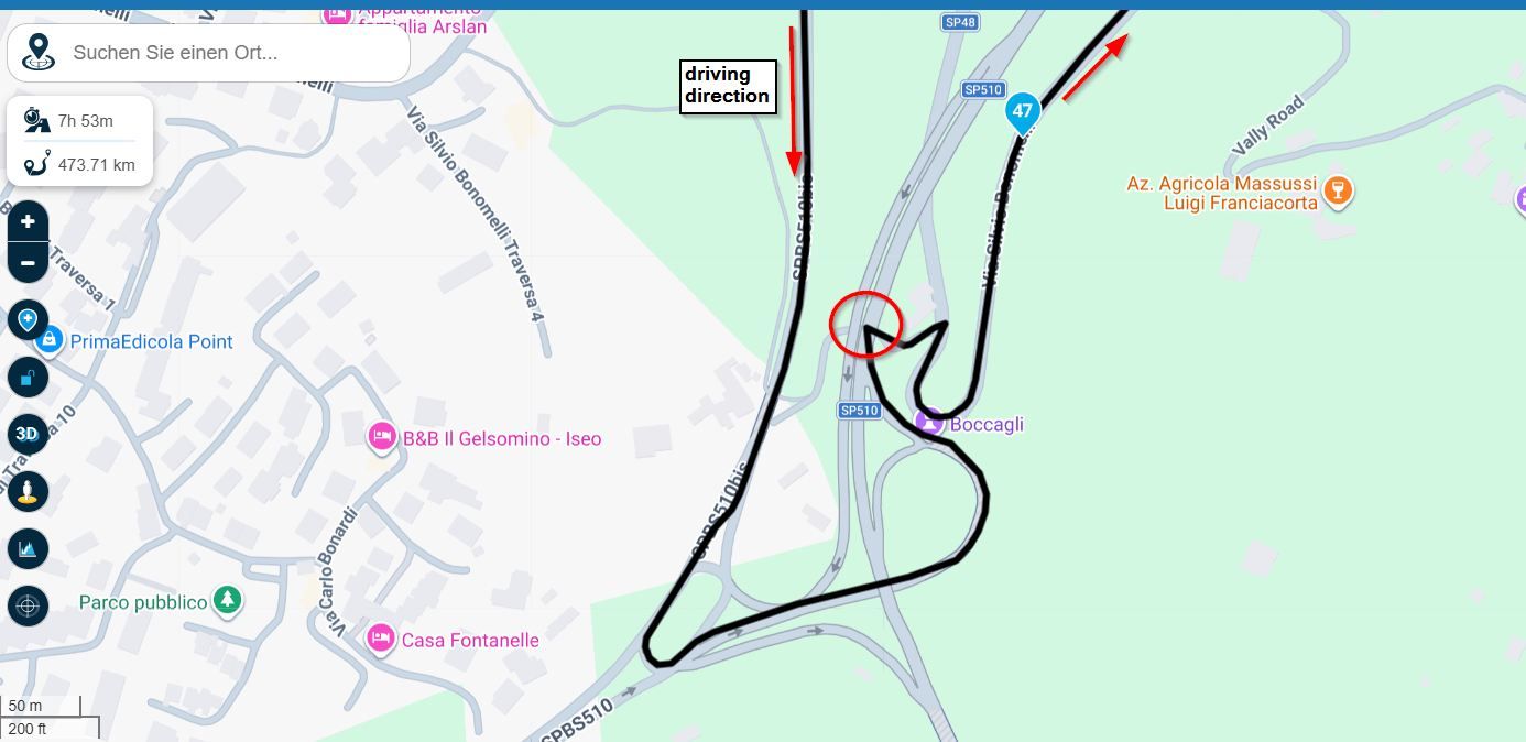
Here is an example of a route (magenta line) and track (yellow line) I want the route to be the same as the track and travel along the B128 but because of the spacing of the shaping points and via points the Zumo XT "Faster Time" algorithm routes down the A28 and up the B45 which adds miles and time to the route. You can fix this in three ways
- Tap the map on the unit (as shown) to add additional shaping ponts to match the track
- Make sure as stated above that there is a waypoint on the B128 as you plan the route
- Use GPX1.2 and make sure that you don't recalculate the route when you are on it by switching off automatic recalculation.
As with all things its a bit of a learning curve and you are doing the right thing by testing and using the unit before you are on a live tour. That is very important.
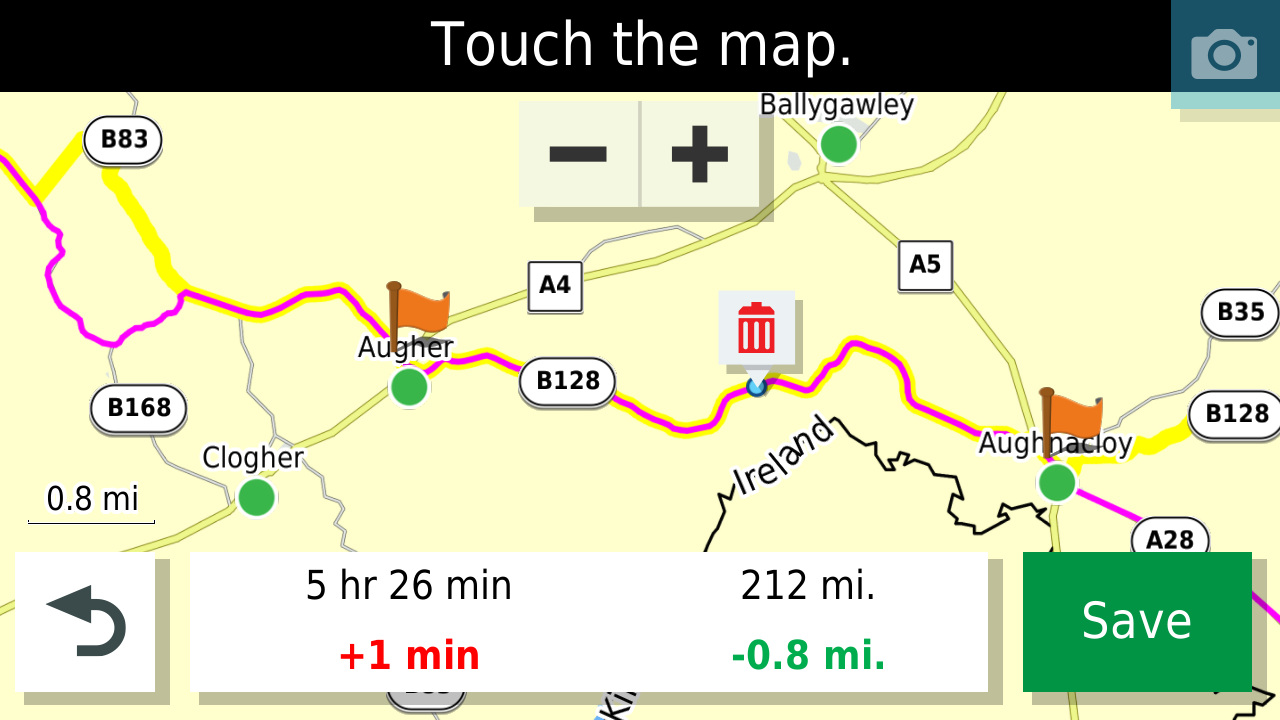
Also when planning your routes put the start some way up the road from where you are actually starting as this ensures that the unit passes through the start point and does not try to take you back to the start as you have missed passing through it by a few metres.
-
@Greenham From John Heaths excellent navigating with a Zumo Guide.
" MyRouteApp.
Very popular and provides a very good
solution. Possible issues for the Zūmo user :
Gpx v1.1
Track, Via Points and Shaping Points. No
Favourites. Zūmo has to calculate route - it
may end up being very different.
GPX v1.2
Track and Via Points. The plot of the route
is also transferred so the roads travelled are
identical to those plotted on the MRA map.
However, if the route is recalculated, it has
only the Via Points to work with. None of
the shaping points are transferred.
If you use this format, it is important not to
do anything that would make the Zūmo
recalculate the route.
Turn off Auto-Recalculate !
No Favourites are transferred to the Zūmo.As stated above I use GPX1.1 and use lots of shaping points and display the track to ensure that my intended route and route as calculated by the XT match. The @ Martin-Wilcke method will also work well as long as you don't use recalculate to navigate back to the route.
Here is an example of a route (magenta line) and track (yellow line) I want the route to be the same as the track and travel along the B128 but because of the spacing of the shaping points and via points the Zumo XT "Faster Time" algorithm routes down the A28 and up the B45 which adds miles and time to the route. You can fix this in three ways
- Tap the map on the unit (as shown) to add additional shaping ponts to match the track
- Make sure as stated above that there is a waypoint on the B128 as you plan the route
- Use GPX1.2 and make sure that you don't recalculate the route when you are on it by switching off automatic recalculation.
As with all things its a bit of a learning curve and you are doing the right thing by testing and using the unit before you are on a live tour. That is very important.
Also when planning your routes put the start some way up the road from where you are actually starting as this ensures that the unit passes through the start point and does not try to take you back to the start as you have missed passing through it by a few metres.
@Mzokk
How do you get the track to display from the zumo?I have several 1.2gpx routes currently loaded on my zumo, but don't see the option to display track.
"There is no problem so bad that you can't make it worse"
- Chris Hadfield (NASA Astronaut)
-
Due to weather conditions, I haven't had a chance to check out MRAs new/enhanced "navigate route as a track" feature in reality so far - but from my understanding, this could be the perfect way to navigate the route exactly as planned (like a track) and having just VIAs visible (similar to GPX 1.2 on an XT) but with the option to activate automatic re-calculation. It mainly depends on the algorithm that leads back to the track.
Do you have any experience with this feature already?
@Martin-Wilcke No Martin I haven't yet tried the navigate route as Track so far. But I have been experimenting for the past 18 months this a phone and my Africa twin Android Auto with a view to relegating the Zumo to a back up. We are nearly there I think. Testing looks silly though
-
@Marinus-van-Deudekom
First thank you all who have tried to help me. It's slowly making sense thanks to you guys. I now understand the difference between planning and overlay maps.I now only use HERE, for planning then compare my work/route with Tom Tom and OSM.
What is still unclear is exporting my route via 1.2gpx and I decide to skip a waypoint. All the following shaping points seem to be ignored and zumo defaults to the default routing method within the GPS (fastest, shortest etc) using the few waypoints that still haven't been passed/used.
Until I understand this behavior I'm lost.
Again I have recalculation off
The key seems to be between 1.1gpx vs 1.2gpx
Should I just be expecting via 1.1 instead of 1.2gpx which is what I have always used
When using GPX 1.2, avoiding recalculation is key as a recalc will affect not just the section to the next VIA but the complete route!
Unfortunately, skipping a VIA will force a recalculation. Most of the time, you will pass all VIAs as planned. If you need to skip a VIA for any reason, the only way I know (on an XT) is as mentioned above:Stop navigating the current route, find your way back (that's where having the track displayed additional to the route can help), and if you get back on track (important!), start navigating your original route again - it will start from your current position.
Avoiding recalculation is the significant downside of using GPX 1.2. If this doesn't match your preferences, GPX 1.1 is probably a better choice.
-
@Mzokk
How do you get the track to display from the zumo?I have several 1.2gpx routes currently loaded on my zumo, but don't see the option to display track.
(picked from jfheath's excellent dokumentation)
-
@Martin-Wilcke No Martin I haven't yet tried the navigate route as Track so far. But I have been experimenting for the past 18 months this a phone and my Africa twin Android Auto with a view to relegating the Zumo to a back up. We are nearly there I think. Testing looks silly though
@Mzokk said in STILL having issues w/ my Zumo XT not following the route:
Testing looks silly though
This could be me!

I switched from Garmin to MRA NN a year ago and never looked back. If the new "route as track" feature works as expected, it's a killer.
In addition to the software, the device is also an issue. I tried a few smartphone solutions (it didn't convince me), then a Carpe Iter (too big) and I'm now with a DMD2 T665. Perfect. Yes, it's expensive, but "buy once, cry once", and you're immediately rid of all the annoying issues (e.g. power draining).
-
@Marinus-van-Deudekom
First thank you all who have tried to help me. It's slowly making sense thanks to you guys. I now understand the difference between planning and overlay maps.I now only use HERE, for planning then compare my work/route with Tom Tom and OSM.
What is still unclear is exporting my route via 1.2gpx and I decide to skip a waypoint. All the following shaping points seem to be ignored and zumo defaults to the default routing method within the GPS (fastest, shortest etc) using the few waypoints that still haven't been passed/used.
Until I understand this behavior I'm lost.
Again I have recalculation off
The key seems to be between 1.1gpx vs 1.2gpx
Should I just be expecting via 1.1 instead of 1.2gpx which is what I have always used
@Greenham said in STILL having issues w/ my Zumo XT not following the route:
@Marinus-van-Deudekom
First thank you all who have tried to help me. It's slowly making sense thanks to you guys. I now understand the difference between planning and overlay maps.I now only use HERE, for planning then compare my work/route with Tom Tom and OSM.
What is still unclear is exporting my route via 1.2gpx and I decide to skip a waypoint. All the following shaping points seem to be ignored and zumo defaults to the default routing method within the GPS (fastest, shortest etc) using the few waypoints that still haven't been passed/used.
Until I understand this behavior I'm lost.
Again I have recalculation off
The key seems to be between 1.1gpx vs 1.2gpx
Should I just be expecting via 1.1 instead of 1.2gpx which is what I have always used
Thas is because: the gpx 1.2, which is a route-track with via points. So no shaping points in the gpx file
-
@Martin-Wilcke
I do not have experience aside from watching Serg do a video on it. Didn't completely understand what they were saying.
@Greenham of you're using a 1.2 and you want to skip a viapoint (there are no shaping points in a 1.2) navigate to the displayed track after the skipped viapoint and then press skip waypoint om your XT. It will then keep on the route
Have you found out how to display the track under the route?Honda Goldwing GL1500,
Honda Silverwing GL 650
DMD2 T865X 8 inch Android tablet using MRA next for navigation
Garmin XT sold
Samsung S24FE mounted on a Quadlock and using Android Auto in my car -
@Greenham of you're using a 1.2 and you want to skip a viapoint (there are no shaping points in a 1.2) navigate to the displayed track after the skipped viapoint and then press skip waypoint om your XT. It will then keep on the route
Have you found out how to display the track under the route?@Marinus-van-Deudekom said in STILL having issues w/ my Zumo XT not following the route:
then press skip waypoint om your XT. It will then keep on the route
I don't know what you mean with "keep on the route", but skipping a VIA will force a recalculation, which may lead to a different result.
Hello! It looks like you're interested in this conversation, but you don't have an account yet.
Getting fed up of having to scroll through the same posts each visit? When you register for an account, you'll always come back to exactly where you were before, and choose to be notified of new replies (either via email, or push notification). You'll also be able to save bookmarks and upvote posts to show your appreciation to other community members.
With your input, this post could be even better 💗
Register Login-
022236
-
08113
-
019390
-
5764
-
0644
-
08173
-
012214
-
0366