Slowenien 🇸🇮 Reise MRA V4.3.0 (335)&(330)&(328) Fragen u. Fehlermeldung von unterwegs.
-
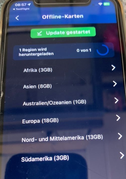
Hey @Corjan-Meijerink, muss ich ein Offline Karten Update machen bevor ich heute mit der Neuen MRA V4.3.0 (328) starte !
-
Neues HERE Layout auch bei Offline ?
-
Muss ich ein Update laden falls es Offline geht soll ?
VG

VG Hubert
Beta Test "Next App" dazu die Hardware .
iPad 9. Gen iOS 26.5.2/ iPhone 16e iOS 26.5.2/ Navi iPhone Xr iOS 18.7.9 / PC mit MS Win11 /❗️MyRoute-App im Cradel und Remotek-One❗️ Info zu MRA & Remotek One -
-
Hey @Corjan-Meijerink, muss ich ein Offline Karten Update machen bevor ich heute mit der Neuen MRA V4.3.0 (328) starte !
-
Neues HERE Layout auch bei Offline ?
-
Muss ich ein Update laden falls es Offline geht soll ?
VG
@Hubert-Thoring not necessary! Only recommended
")
Do only update your maps when using a good internet connection. Never in a rush in your hotel. -
-
@Hubert-Thoring not necessary! Only recommended
Do only update your maps when using a good internet connection. Never in a rush in your hotel.@Corjan-Meijerink : I thought, so now at home there is up to 1GByte /s here
 .
.Thanks for the App gift
- Europa mit 18 GByte dauert so immer noch ca. 30Min …
VG Hubert
Beta Test "Next App" dazu die Hardware .
iPad 9. Gen iOS 26.5.2/ iPhone 16e iOS 26.5.2/ Navi iPhone Xr iOS 18.7.9 / PC mit MS Win11 /❗️MyRoute-App im Cradel und Remotek-One❗️ Info zu MRA & Remotek One -
@Corjan-Meijerink : I thought, so now at home there is up to 1GByte /s here
.Thanks for the App gift
- Europa mit 18 GByte dauert so immer noch ca. 30Min …
@Hubert-Thoring said in Slowenien
 Reise MRA V4.3.0 (328) Fragen u. Fehlermeldung von unterwegs.:
now at home there is up to 1GByte /s here .
Your wifi will not be able to use all that, even if your provider offers it
I am just an enthusiastic MRA user, and hope you will be one too!
Most motorcycle problems are caused by the nut that connects the handlebar to the saddle.
Check out RideSleepRepeat.eu, a biker community for sharing stays across Europe
-
@Hubert-Thoring said in Slowenien
Reise MRA V4.3.0 (328) Fragen u. Fehlermeldung von unterwegs.:now at home there is up to 1GByte /s here .
Your wifi will not be able to use all that, even if your provider offers it
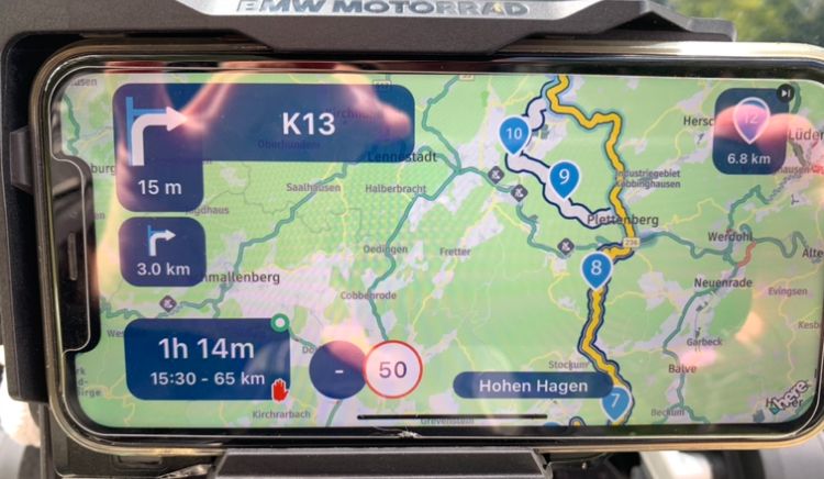
1.) WP are now seemingly skipped faster than usual or, at least that's how I feel.
-
Is very confusing should not be like that, was on the route all the time, maybe no GPS signal in the short term, but I don't think so either, maybe too many tight curves / narrow turns.
-
I then followed the new route s. yellow line
As a result: I set the automatic WP skip to "OFF" for Slovenia.
Card colors are great, especially on large streets that need to be avoided, I am currently using the "logistics" map. Now better "Standard" is better red highway be „Wong“ using.
Logistig: Dart

Standart: Wrong

VG Hubert
Beta Test "Next App" dazu die Hardware .
iPad 9. Gen iOS 26.5.2/ iPhone 16e iOS 26.5.2/ Navi iPhone Xr iOS 18.7.9 / PC mit MS Win11 /❗️MyRoute-App im Cradel und Remotek-One❗️ Info zu MRA & Remotek One -
-
1.) WP are now seemingly skipped faster than usual or, at least that's how I feel.
-
Is very confusing should not be like that, was on the route all the time, maybe no GPS signal in the short term, but I don't think so either, maybe too many tight curves / narrow turns.
-
I then followed the new route s. yellow line
As a result: I set the automatic WP skip to "OFF" for Slovenia.
Card colors are great, especially on large streets that need to be avoided, I am currently using the "logistics" map. Now better "Standard" is better red highway be „Wong“ using.
Logistig: Dart
Standart: Wrong
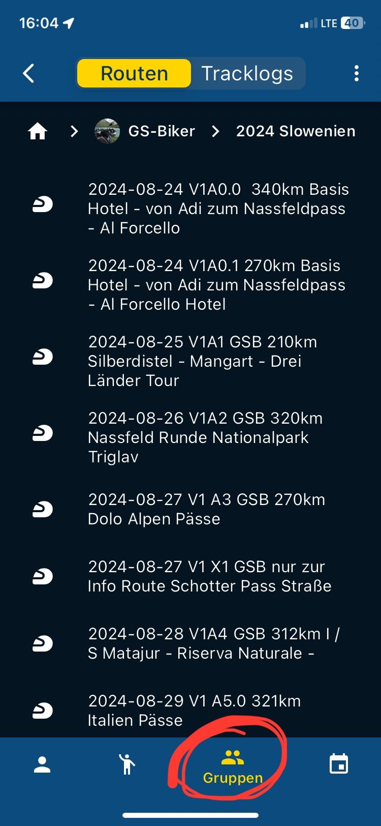
Exchange Group Routes
-
It would be more helpful if you comb back to the overview with one click
-
from here s. Picture 1 to picture 2
Picture 1
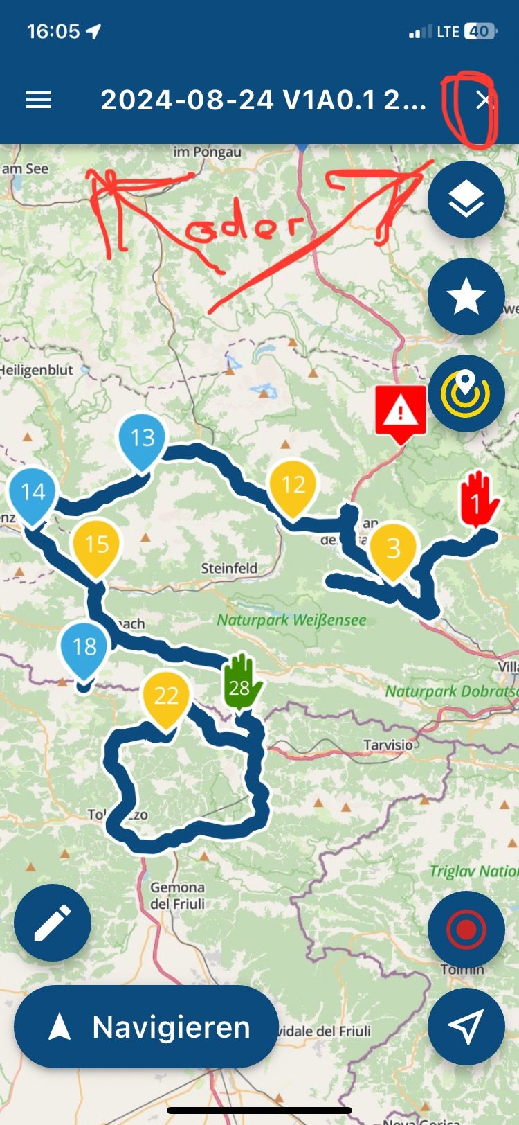
Picture 2
VG Hubert
Beta Test "Next App" dazu die Hardware .
iPad 9. Gen iOS 26.5.2/ iPhone 16e iOS 26.5.2/ Navi iPhone Xr iOS 18.7.9 / PC mit MS Win11 /❗️MyRoute-App im Cradel und Remotek-One❗️ Info zu MRA & Remotek One -
-
Exchange Group Routes
-
It would be more helpful if you comb back to the overview with one click
-
from here s. Picture 1 to picture 2
Picture 1
Picture 2
Greetings from the Nassfeldpass border I/A, the Slovenia
Italy  and Austria
  tour, here is often bad network outside the hotel.
Now we (the 3 GS bikers) have understood it, in the app we have to open the tour in the hotel in the group, then as an external user who did not create the group, download the route, and then it is only really available offline for offline routes.
We already had it like that, loading from the / group / route and starting to navigate, on the road problems, construction site / closure etc. App stopped ended for whatever reason. Then you hardly believe it no network. What do you do then

Suggestion:
If you open a route in the group and start the navigation, this route should also be available in the app in offline. Currently, even as a user before in the hotel with network, I have to additionally take care of downloading, which can be difficult in groups.
So every route should be automatically available offline when using it.
It leads to frustration on the road in the group, which is unpleasant as a guide
==> Link : https://forum.myrouteapp.com/post/53930
VG Hubert the 1st of the 3 GS bikers
VG Hubert
Beta Test "Next App" dazu die Hardware .
iPad 9. Gen iOS 26.5.2/ iPhone 16e iOS 26.5.2/ Navi iPhone Xr iOS 18.7.9 / PC mit MS Win11 /❗️MyRoute-App im Cradel und Remotek-One❗️ Info zu MRA & Remotek One -
-
Greetings from the Nassfeldpass border I/A, the Slovenia
Italy and Austria tour, here is often bad network outside the hotel.Now we (the 3 GS bikers) have understood it, in the app we have to open the tour in the hotel in the group, then as an external user who did not create the group, download the route, and then it is only really available offline for offline routes.
We already had it like that, loading from the / group / route and starting to navigate, on the road problems, construction site / closure etc. App stopped ended for whatever reason. Then you hardly believe it no network. What do you do then
Suggestion:
If you open a route in the group and start the navigation, this route should also be available in the app in offline. Currently, even as a user before in the hotel with network, I have to additionally take care of downloading, which can be difficult in groups.
So every route should be automatically available offline when using it.
It leads to frustration on the road in the group, which is unpleasant as a guide
==> Link : https://forum.myrouteapp.com/post/53930
VG Hubert the 1st of the 3 GS bikers
The topic of being ready for a tour offline appears in regions/border areas such as Slovenia
and Italy to be important Choosing a route in the hotel with WLan or network from your own area or a group should make it possible that this route is immediately available offline. Because thinking about it is also difficult because of all other topics .., the most beautiful route and weather etc. If there is no network available on the way, it is off and no longer fun.
Everything else in the app is wonderfully solved with the last update v4.3.0 (331), thanks for that.
VG
VG Hubert
Beta Test "Next App" dazu die Hardware .
iPad 9. Gen iOS 26.5.2/ iPhone 16e iOS 26.5.2/ Navi iPhone Xr iOS 18.7.9 / PC mit MS Win11 /❗️MyRoute-App im Cradel und Remotek-One❗️ Info zu MRA & Remotek One -
The topic of being ready for a tour offline appears in regions/border areas such as Slovenia
and Italy to be important Choosing a route in the hotel with WLan or network from your own area or a group should make it possible that this route is immediately available offline. Because thinking about it is also difficult because of all other topics .., the most beautiful route and weather etc. If there is no network available on the way, it is off and no longer fun.
Everything else in the app is wonderfully solved with the last update v4.3.0 (331), thanks for that.
VG
Hey Corjan, today with best regards from Lake Garda, this is Arco. The MRA is a round thing I actually lack nothing in the operation and application anymore.
What stands out:
- Abbreviations in mountain villages or places with impossible proposals the steep very narrow roads are, also partly not harmless.
Can you change that or is it HERE to search internally?
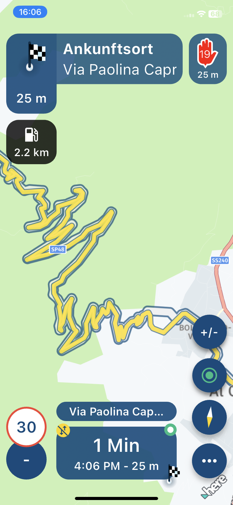
- Two pictures, the track is the SP48 and the white piece the proposal ...
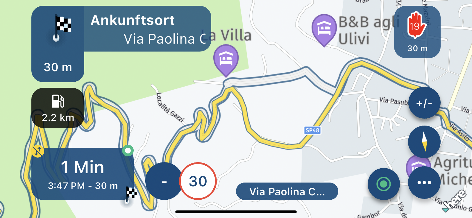
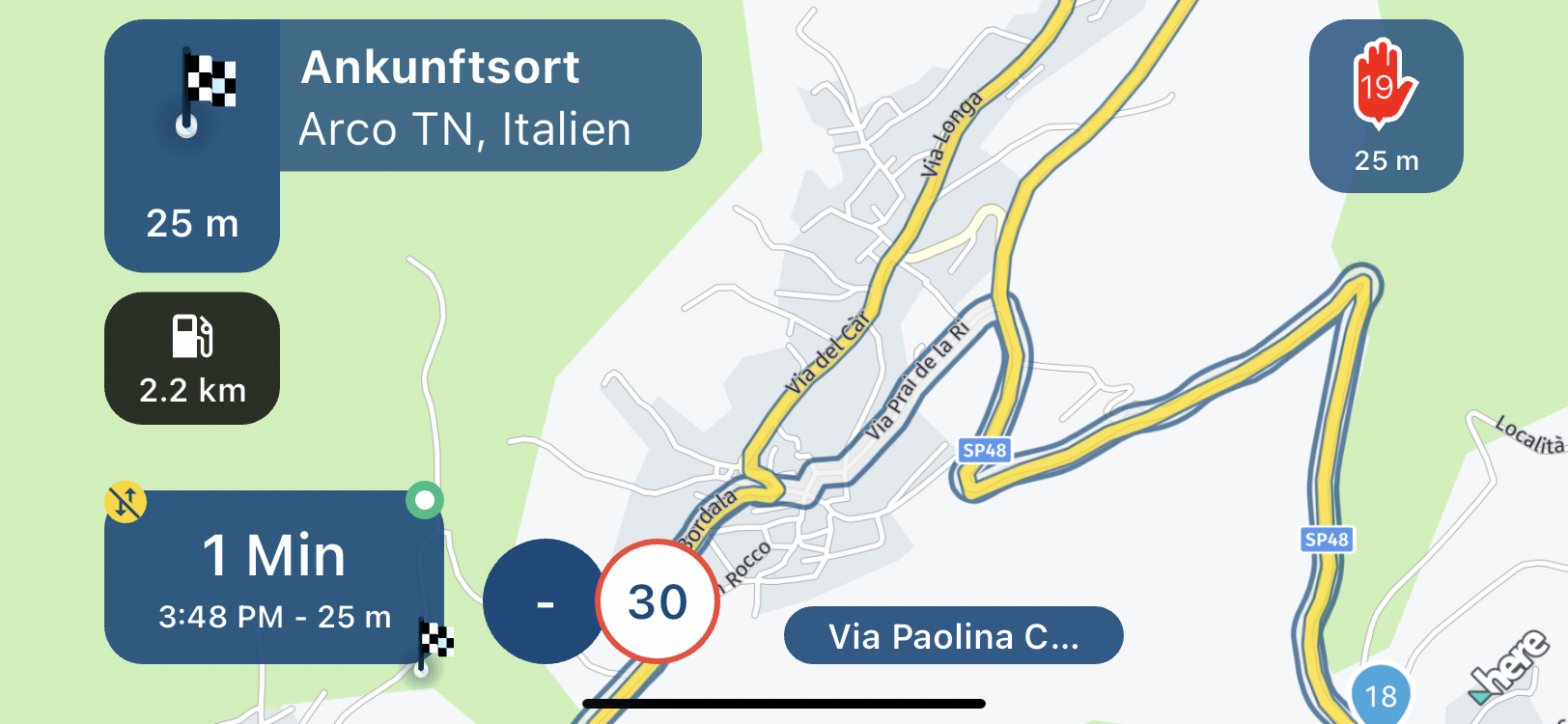
Cool route the SP48, a lot of small bends and narrow route, and below then the abbreviation s. white section. Since I know, I just drive on and then come back to the intersection...
-
@Corjan-Meijerink :Hey Corjan,
Yes, I wish you a nice holiday first, I hope with the motorcycle
Topic Seasonal closures:
Noticed:
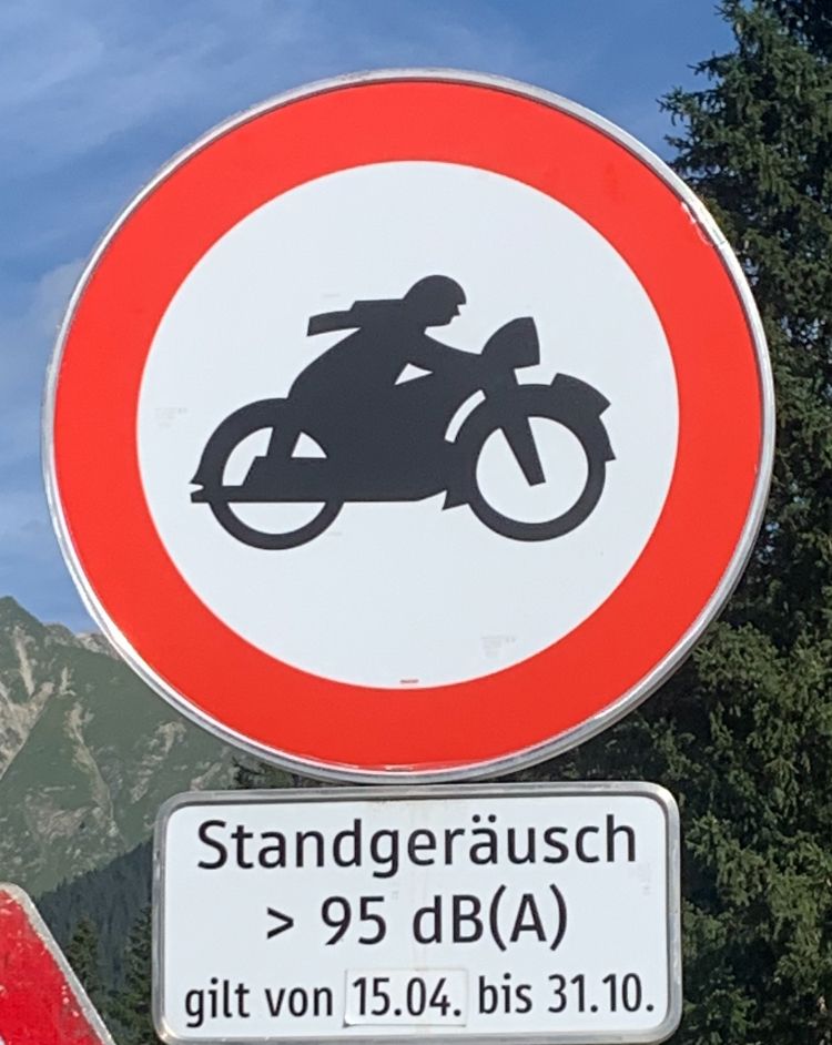
- On the return trip, a route was routed differently than I wanted. The reason was the restriction >95dB(A) on the Hahntennjoch.
Suggestion: Enter the motorcycle data in the MRA planning and / or app
-
Enter technical key data motorcycle like WoMo, here the noises in the stand
-
Motorcycle locks are checked on the basis of the data
Result:
- Route is then calculated according to e.g. dB(A). My R1250GS has a value of 88dB(A) with BJ2023 and should have taken the route normally with the pass. So no blocking for my GS.
Would such an option be possible in MyRoute / the app ...
== > Link: https://forum.myrouteapp.com/post/53931
The sign:
-
@Peter-Schiefer said in Slowenien
Reise MRA V4.3.0 (330)&(328) Fragen u. Fehlermeldung von unterwegs.:A freight forwarder needs more data than a private car driver and he needs mor actual datas and he pays more for such service.
Of course all navigation apps are bound by what they get from the map provider. An attribute for noise restrictions is easily added, I really don't know if the alreay did that or not, but eventually they will need to. Since it is an attribute relevant to everyday personal transport, it would be ultimately dumb to put it in a different license structure. But yeah, you never know. Ultimately it is MRA who decides whether they put in in their app, once it is available.
-
@Peter-Schiefer, Motorcyclists are MRA's core targeted group. I have no doubt that motorcycle restrictions would be added when they are available.
I am just an enthusiastic MRA user, and hope you will be one too!
Most motorcycle problems are caused by the nut that connects the handlebar to the saddle.
Check out RideSleepRepeat.eu, a biker community for sharing stays across Europe
-
@Peter-Schiefer, Motorcyclists are MRA's core targeted group. I have no doubt that motorcycle restrictions would be added when they are available.
Hey Next Team,
Hey @Corjan-Meijerink ,Thank you, everything is very good, the best app for a trip, fast flexible and much more. The latest version is perfect for a flexible motorcycle trip
 ️
️In total it was 4300km in 16 days on bike in Slovenia
, Italy and Austria and of course Germany  ...
...Thank you for the fact that the app has always generated great ways for me, it is good that you can now save a track in the app and make a route out of it, unfortunately at the moment only that in the route laboratory.
With such a route you are perfectly on the road and at construction sites
 flexible far easy to the next WP the skipping helps a lot. Because then you just drive left or right and the app Route is calculated accordingly.
I'm thrilled 🤩
VG Hubert
Beta Test "Next App" dazu die Hardware .
iPad 9. Gen iOS 26.5.2/ iPhone 16e iOS 26.5.2/ Navi iPhone Xr iOS 18.7.9 / PC mit MS Win11 /❗️MyRoute-App im Cradel und Remotek-One❗️ Info zu MRA & Remotek One -
Hey Next Team,
Hey @Corjan-Meijerink ,Thank you, everything is very good, the best app for a trip, fast flexible and much more. The latest version is perfect for a flexible motorcycle trip
️In total it was 4300km in 16 days on bike in Slovenia
, Italy and Austria and of course Germany ...Thank you for the fact that the app has always generated great ways for me, it is good that you can now save a track in the app and make a route out of it, unfortunately at the moment only that in the route laboratory.
With such a route you are perfectly on the road and at construction sites
flexible far easy to the next WP the skipping helps a lot. Because then you just drive left or right and the app Route is calculated accordingly.I'm thrilled 🤩
@Hubert-Thoring awesome!
Happy to hear you enjoyed the app as companion on your vacation!I’m visiting Slovenia tomorrow!

-
@Hubert-Thoring awesome!
Happy to hear you enjoyed the app as companion on your vacation!I’m visiting Slovenia tomorrow!
Hello! It looks like you're interested in this conversation, but you don't have an account yet.
Getting fed up of having to scroll through the same posts each visit? When you register for an account, you'll always come back to exactly where you were before, and choose to be notified of new replies (either via email, or push notification). You'll also be able to save bookmarks and upvote posts to show your appreciation to other community members.
With your input, this post could be even better 💗
Register Login-
017197
-
0898
-
012224
-
011192
-
7382.5k
-
0222
-
05100
-
012513
