This is routing incorrectly isn't it?!?
-
@Tim-Watson Hi Tim
Your shapingpoint 6 and especially your viapoint 5 are off the route. My guess is that due to the crossing in the route MRA couldn't determine the right path do therefore skipped viapoint 5 and calculated as it did.
Could you try it again with the points exactly on the route. To do so make sure you zoom in Max@Marinus-van-Deudekom said in This is routing incorrectly isn't it?!?:
My guess is that due to the crossing in the route MRA couldn't determine the right path do therefore skipped viapoint 5 and calculated as it did.
A VIA point is there to NOT be autoskipped. If a waypoint is too far off a road so that it cannot be reached, you will get a warning and the route wil not start at all. So I do not think that is it.
@Tim-Watson, do I understand correctly that you were navigating this route on your Nav6? In that case the device itself chooses how to navigate between waypoints. the (non?) logic to skip WP5 therefore is inherent to the device, not the route. It looks like a really small loop. Maybe there is some logic in the device to prevent those (usually unwanted) loops, I really cant say.
I am just an enthusiastic MRA user, and hope you will be one too!
Most motorcycle problems are caused by the nut that connects the handlebar to the saddle.
Check out RideSleepRepeat.eu, a biker community for sharing stays across Europe
-
@Tim-Watson Hi Tim
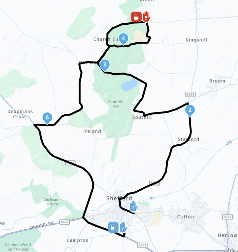
Took another glance at it with the PC and then I saw the light:
1: You've made the route with the motor profil on
2: I changed it to auto witch is the only type you can use at this moment with the Here maps. Then it became quit clear. The route that you wanted to go is beeing altered and giving you the route isues that you had.
3 solution: I added a couple of shaping points and that should do the trick.
It looks like this:
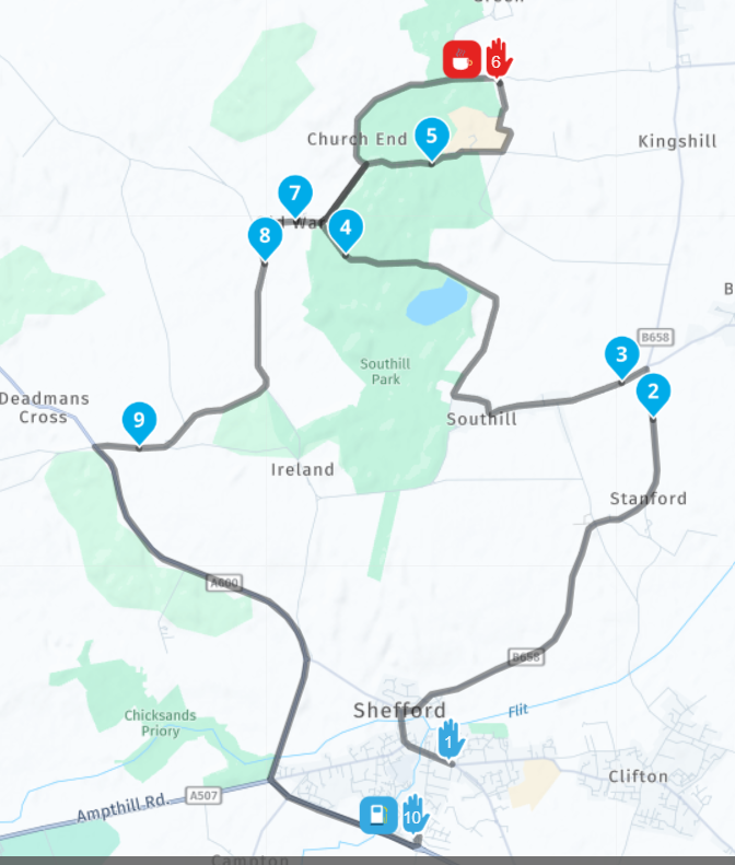
Here's the url to the route I've changed:
https://www.myrouteapp.com/route/open/9782354
If you have another testrun I think it will provide you want you wanted.
My comments in the first responce are nevertheless valid. You can see that I've placed the shaping and viapoint ON the route. Thus making shure the desired route is calculated.
make your routes with the auto profil on")
@Marinus-van-Deudekom said in This is routing incorrectly isn't it?!?:
1: You've made the route with the motor profil on
2: I changed it to auto witch is the only type you can use at this moment with the Here maps.Although there have been some problems related to the Motorbike profile, it is absolutely untrue to says that it does not work with HERE maps. It is perfectly usable, even if there are circumstances in which it might be better to use CAR profile instead.
I am just an enthusiastic MRA user, and hope you will be one too!
Most motorcycle problems are caused by the nut that connects the handlebar to the saddle.
Check out RideSleepRepeat.eu, a biker community for sharing stays across Europe
-
@Marinus-van-Deudekom said in This is routing incorrectly isn't it?!?:
My guess is that due to the crossing in the route MRA couldn't determine the right path do therefore skipped viapoint 5 and calculated as it did.
A VIA point is there to NOT be autoskipped. If a waypoint is too far off a road so that it cannot be reached, you will get a warning and the route wil not start at all. So I do not think that is it.
@Tim-Watson, do I understand correctly that you were navigating this route on your Nav6? In that case the device itself chooses how to navigate between waypoints. the (non?) logic to skip WP5 therefore is inherent to the device, not the route. It looks like a really small loop. Maybe there is some logic in the device to prevent those (usually unwanted) loops, I really cant say.
@Con-Hennekens Hi. No, I used a Nav6 before this week, but this week am trying out MRA and a Chigee with Android Auto. It's not going very well. Back to the Nav6 for now.
-
@Marinus-van-Deudekom said in This is routing incorrectly isn't it?!?:
1: You've made the route with the motor profil on
2: I changed it to auto witch is the only type you can use at this moment with the Here maps.Although there have been some problems related to the Motorbike profile, it is absolutely untrue to says that it does not work with HERE maps. It is perfectly usable, even if there are circumstances in which it might be better to use CAR profile instead.
Although there have been some problems related to the Motorbike profile, it is absolutely untrue to says that it does not work with HERE maps. It is perfectly usable, even if there are circumstances in which it might be better to use CAR profile instead.
Can you explain what these problems with the motorcycle profile have been? I can't find anything that says which to use, or indeed which to avoid.
-
@Marinus-van-Deudekom said in This is routing incorrectly isn't it?!?:
1: You've made the route with the motor profil on
2: I changed it to auto witch is the only type you can use at this moment with the Here maps.Although there have been some problems related to the Motorbike profile, it is absolutely untrue to says that it does not work with HERE maps. It is perfectly usable, even if there are circumstances in which it might be better to use CAR profile instead.
@Con-Hennekens hoi @Con-Hennekens
The advice from the devs is not to use the profile. Like in Tim's case it causes problems that at completely unnecessary. I agree with the devs. Maybe you can explain what would be useful in the bike profile. I could guess like maybe road closures für bikes but I experienced that even that doesn't work at this time. What could be the advantage of that profile. -
@Con-Hennekens hoi @Con-Hennekens
The advice from the devs is not to use the profile. Like in Tim's case it causes problems that at completely unnecessary. I agree with the devs. Maybe you can explain what would be useful in the bike profile. I could guess like maybe road closures für bikes but I experienced that even that doesn't work at this time. What could be the advantage of that profile.Maybe @Corjan-Meijerink can give an authoritative answer straight from the horse’s mouth on the use of the motorcycle profile, both in planning mode and navigation mode (some of us only use MRA for planning).
It’s important to know if we shouldn’t be using these modes, and if it is the case then it needs to be made more prominent to stop new users being unaware and having a really bad experience. You can see from the original post in this thread that the new user has gone back to the Nav VI because of a bad experience. That’s not good if the root cause is something that was known about but poorly communicated.
-
Hallo,
Please look at,
Toolkit / Avoid / Unpaved Roads
These settings must be readjusted for each new route, Why?
-
Maybe @Corjan-Meijerink can give an authoritative answer straight from the horse’s mouth on the use of the motorcycle profile, both in planning mode and navigation mode (some of us only use MRA for planning).
It’s important to know if we shouldn’t be using these modes, and if it is the case then it needs to be made more prominent to stop new users being unaware and having a really bad experience. You can see from the original post in this thread that the new user has gone back to the Nav VI because of a bad experience. That’s not good if the root cause is something that was known about but poorly communicated.
@Dae-0 said in This is routing incorrectly isn't it?!?:
Maybe @Corjan-Meijerink can give an authoritative answer straight from the horse’s mouth on the use of the motorcycle profile, both in planning mode and navigation mode (some of us only use MRA for planning).
I happen to know that @Corjan-Meijerink uses the motorbike profile almost exclusively himself. The motorbike profile is there because it is included in the HERE SDK. Maybe Corjan cares to elaborate?
Roads exist that are closed for 4 wheels, but are open for 2 wheels.
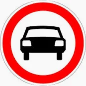
Closures with this sign are not closed for motorbikes. I can only assume the motorbike profile takes that into account correctly.
@Tim-Watson said in This is routing incorrectly isn't it?!?:
Can you explain what these problems with the motorcycle profile have been?
There was a problem with showing the wrong exit at roundabouts that appeared to be exclusively for the motorbike profile. I understand that this has been solved for some time already.
Also there is an ongoing problem where route optimization as "shortest" instead of "quickest" is not available for the motorbike profile. That is mainly a problem if you want to go over scheduled ferries. In that case it is advised to switch to car profile and the "shortest route" optimization.
I am just an enthusiastic MRA user, and hope you will be one too!
Most motorcycle problems are caused by the nut that connects the handlebar to the saddle.
Check out RideSleepRepeat.eu, a biker community for sharing stays across Europe
-
@Dae-0 said in This is routing incorrectly isn't it?!?:
Maybe @Corjan-Meijerink can give an authoritative answer straight from the horse’s mouth on the use of the motorcycle profile, both in planning mode and navigation mode (some of us only use MRA for planning).
I happen to know that @Corjan-Meijerink uses the motorbike profile almost exclusively himself. The motorbike profile is there because it is included in the HERE SDK. Maybe Corjan cares to elaborate?
Roads exist that are closed for 4 wheels, but are open for 2 wheels.
Closures with this sign are not closed for motorbikes. I can only assume the motorbike profile takes that into account correctly.
@Tim-Watson said in This is routing incorrectly isn't it?!?:
Can you explain what these problems with the motorcycle profile have been?
There was a problem with showing the wrong exit at roundabouts that appeared to be exclusively for the motorbike profile. I understand that this has been solved for some time already.
Also there is an ongoing problem where route optimization as "shortest" instead of "quickest" is not available for the motorbike profile. That is mainly a problem if you want to go over scheduled ferries. In that case it is advised to switch to car profile and the "shortest route" optimization.
@Con-Hennekens this is what I mean @Con-Hennekens the bike profile doesn’t look at the closed roads for bikes. I Hope @Corjan-Meijerink will give his final verdict so we can close this part of the subject
-
Maybe @Corjan-Meijerink can give an authoritative answer straight from the horse’s mouth on the use of the motorcycle profile, both in planning mode and navigation mode (some of us only use MRA for planning).
It’s important to know if we shouldn’t be using these modes, and if it is the case then it needs to be made more prominent to stop new users being unaware and having a really bad experience. You can see from the original post in this thread that the new user has gone back to the Nav VI because of a bad experience. That’s not good if the root cause is something that was known about but poorly communicated.
@Dae-0 said in This is routing incorrectly isn't it?!?:
You can see from the original post in this thread that the new user has gone back to the Nav VI because of a bad experience. That’s not good if the root cause is something that was known about but poorly communicated.
That for sure is true. However it is known that almost no one reads such a documentation. Most people just ask questions on the forum, and many users are here to help
")
Concerning @Tim-Watson his bad experience, it is very likely that probably unintentional some skipping buttons were pressed. A VIA point (hand symbol) does not get skipped automatically. Therefore it is good info whether the problem reoccurs. If it does, it is best to submit a support ticket, so the devs can ask for logs to check what's wrong.
-
@Con-Hennekens this is what I mean @Con-Hennekens the bike profile doesn’t look at the closed roads for bikes. I Hope @Corjan-Meijerink will give his final verdict so we can close this part of the subject
@Marinus-van-Deudekom said in This is routing incorrectly isn't it?!?:
the bike profile doesn’t look at the closed roads for bikes.
Can you substantiate that with an example? It would be very good to know, and to mention to HERE.
I am just an enthusiastic MRA user, and hope you will be one too!
Most motorcycle problems are caused by the nut that connects the handlebar to the saddle.
Check out RideSleepRepeat.eu, a biker community for sharing stays across Europe
-
@Marinus-van-Deudekom said in This is routing incorrectly isn't it?!?:
the bike profile doesn’t look at the closed roads for bikes.
Can you substantiate that with an example? It would be very good to know, and to mention to HERE.
@Con-Hennekens yes I can
Making an route for my RouteXpert training I couldn’t find why a street was impossible to drive trough with the OSM. Looking at the situation Sith streetview I discovered that thé Riad was closed for bikes. Here and TomTom didn’t have that problem. Changing to the bike profile didn’t change anything. So for once OSM was right.
Other example if you want to cross a river by ferry. Most of the times the bike profile will lead to a non ferry crossing of the river where when using the car profile you can cross the river by ferry -
@Con-Hennekens yes I can
Making an route for my RouteXpert training I couldn’t find why a street was impossible to drive trough with the OSM. Looking at the situation Sith streetview I discovered that thé Riad was closed for bikes. Here and TomTom didn’t have that problem. Changing to the bike profile didn’t change anything. So for once OSM was right.
Other example if you want to cross a river by ferry. Most of the times the bike profile will lead to a non ferry crossing of the river where when using the car profile you can cross the river by ferry@Marinus-van-Deudekom said in This is routing incorrectly isn't it?!?:
Making an route for my RouteXpert training I couldn’t find why a street was impossible to drive trough with the OSM. Looking at the situation Sith streetview I discovered that thé Riad was closed for bikes. Here and TomTom didn’t have that problem. Changing to the bike profile didn’t change anything. So for once OSM was right.
Yes, but that does not proof that the motorbike profile does not honor the car-only closure correctly. It more like proofs that HERE and TomTom are unaware (yet) of the bike-closure. Did you check that with HERE and TomTom?
Other example if you want to cross a river by ferry. Most of the times the bike profile will lead to a non ferry crossing of the river where when using the car profile you can cross the river by ferry
I already explained that above, and this is also no proof of the motorbike profile to disregard roads that are open for bikes but not for cars.
I am just an enthusiastic MRA user, and hope you will be one too!
Most motorcycle problems are caused by the nut that connects the handlebar to the saddle.
Check out RideSleepRepeat.eu, a biker community for sharing stays across Europe
-
@Marinus-van-Deudekom said in This is routing incorrectly isn't it?!?:
Making an route for my RouteXpert training I couldn’t find why a street was impossible to drive trough with the OSM. Looking at the situation Sith streetview I discovered that thé Riad was closed for bikes. Here and TomTom didn’t have that problem. Changing to the bike profile didn’t change anything. So for once OSM was right.
Yes, but that does not proof that the motorbike profile does not honor the car-only closure correctly. It more like proofs that HERE and TomTom are unaware (yet) of the bike-closure. Did you check that with HERE and TomTom?
Other example if you want to cross a river by ferry. Most of the times the bike profile will lead to a non ferry crossing of the river where when using the car profile you can cross the river by ferry
I already explained that above, and this is also no proof of the motorbike profile to disregard roads that are open for bikes but not for cars.
This post is deleted! -
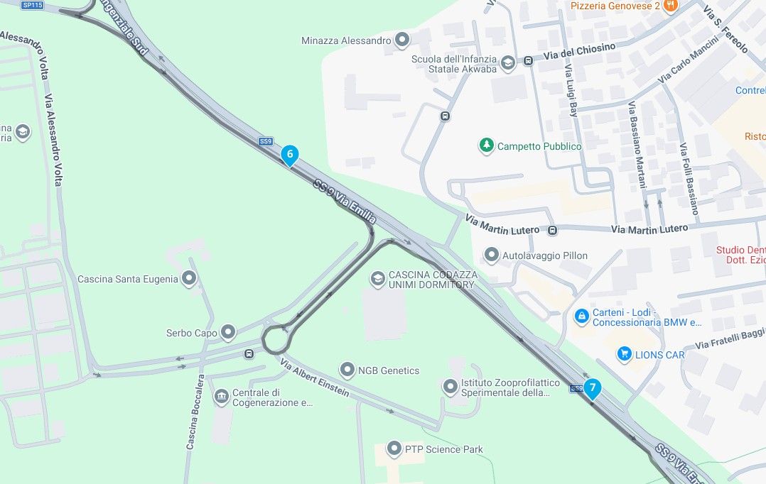
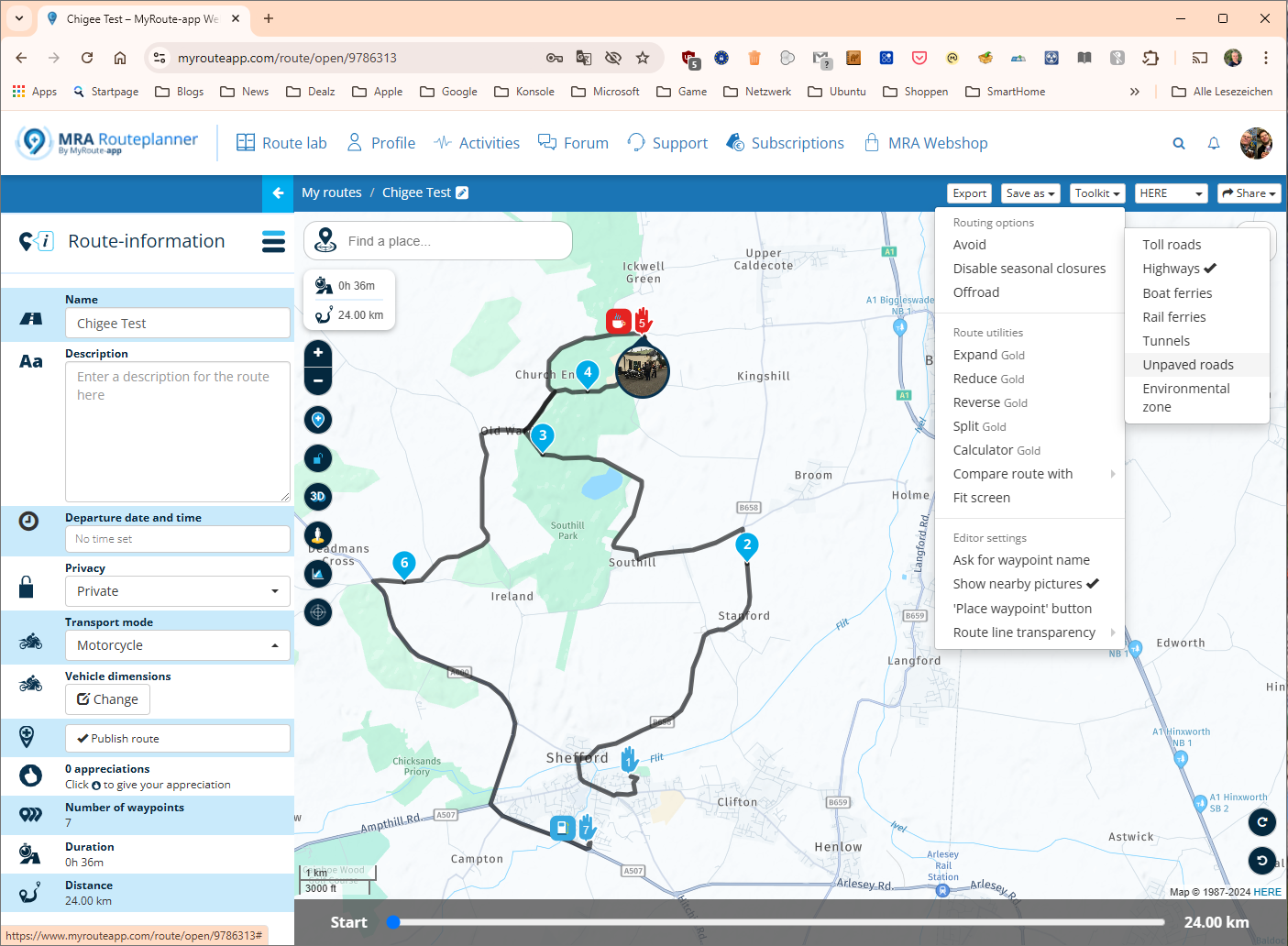
So I'm testing MRA via Android Auto on a Chigee AIO-5 (spoiler - what a disaster, back to the Nav6), and I created a test route that routes in a way I wouldn't expect.
Starting at 1, I'd expect it to route to 2, 3, 4 and then 5 which is a via point. No. It routes 1 to 2 to 3, and at the t-junction after 3 it turns left towards 6. What?! Auto skipping of waypoints was on, but my understanding is that it never skips via points, only shaping points. So why would it turn left after waypoint 3?
Am I misunderstanding something?
@Tim-Watson said in This is routing incorrectly isn't it?!?:
So I'm testing MRA via Android Auto on a Chigee AIO-5 (spoiler - what a disaster, back to the Nav6), and I created a test route that routes in a way I wouldn't expect.
Why is using the Chigee a disaster?
Hello! It looks like you're interested in this conversation, but you don't have an account yet.
Getting fed up of having to scroll through the same posts each visit? When you register for an account, you'll always come back to exactly where you were before, and choose to be notified of new replies (either via email, or push notification). You'll also be able to save bookmarks and upvote posts to show your appreciation to other community members.
With your input, this post could be even better 💗
Register Login-
0456.3k
-
0721
-
0470
-
021383
-
06838.3k
-
010251
-
0262
-
138119