Zoom Scale
-
Hi guys, in the meantime I really like the MRA functionality and it is my preferred app for navigation via a smartphone. I hope the battery drain will get solved as this is IMO the major disadvantage here. I know you work with HERE but other apps like Scenic use HERE too and do not have such power consumption.
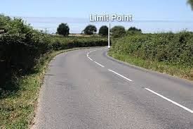
One think that I am missing is a zoom scale telling me for instance how sharfp a upcoming turn / curve is so I can adapt my speed - yet I know thios only if I know at which zoomlevel I am currently on my map. Would it be possible to add this to the map layout?
Many thanks for this cool app anyway
Adam
iPhone 14 pro max
BMW R1250GS -
Hi guys, in the meantime I really like the MRA functionality and it is my preferred app for navigation via a smartphone. I hope the battery drain will get solved as this is IMO the major disadvantage here. I know you work with HERE but other apps like Scenic use HERE too and do not have such power consumption.
One think that I am missing is a zoom scale telling me for instance how sharfp a upcoming turn / curve is so I can adapt my speed - yet I know thios only if I know at which zoomlevel I am currently on my map. Would it be possible to add this to the map layout?
Many thanks for this cool app anyway
Adam
hi @Adam-Sobanski said in Zoom Scale:
One think that I am missing is a zoom scale telling me for instance how sharfp a upcoming turn / curve is so I can adapt my speed
doesn't this tell you how sharp a curve is, when it is moving away you can speed up, moving closer you should slow down.
for me it is much safer to rely on my road skills than a nav screen, yes the screen may show me that i have a series of bends or a switchback ahead, but, personally i would not regulate my speed on the reliance of a nav screen
to achieve, we must first attempt ✌️
K1600 GTL
Oukitel RT3
iPhone 13 Pro, carpuride 702b -
hi @Adam-Sobanski said in Zoom Scale:
One think that I am missing is a zoom scale telling me for instance how sharfp a upcoming turn / curve is so I can adapt my speed
doesn't this tell you how sharp a curve is, when it is moving away you can speed up, moving closer you should slow down.
for me it is much safer to rely on my road skills than a nav screen, yes the screen may show me that i have a series of bends or a switchback ahead, but, personally i would not regulate my speed on the reliance of a nav screen
@paul69 Hi Paul, thanks for the comment - yet, I did not ask for a teaching how to ride safely but for a functionality that should be standard anyway on a map. Regards, Adam
-
Having a visible scale in itself is not a bad idea, it gives reference to how far you are actually looking forward on the map. To be readable though, it would likely take up too much screen estate.
I disagree that it is like a standard feature, since most apps and devices I know don't have that either. Paper maps usually do, but they don't zoom
") . I do agree that it is ill practise to use it as a method for deciding how fast to approach corners.
. I do agree that it is ill practise to use it as a method for deciding how fast to approach corners.I am just an enthusiastic MRA user, and hope you will be one too!
Most motorcycle problems are caused by the nut that connects the handlebar to the saddle.
Check out RideSleepRepeat.eu, a biker community for sharing stays across Europe
-
How would the scale work when you have your map view set with tilt. Parallax would make any scale inaccurate and therefore worthless.
Always willing to help if I can.
Triumph Tiger 1200 XRT called Tina.
MRA Navigation Next and SilverFox BJ8 -
How would the scale work when you have your map view set with tilt. Parallax would make any scale inaccurate and therefore worthless.
@Nick-Carthew, good point, but I think that it is still possible. I remember an earlier suggestion I posed, to make the circle around the flyer a fixed size, let's say 25 mtrs in diameter on the map for example. The further you are zoomed out, the smaller that circle gets, giving you an indication of the scale. Only the scale at the position of the flyer is interesting I think, because you can relate that to your position in the real world. And this is not exact like a scale on a paper map, but noone is measuring distances on screen with a ruler to calculate the distance in reality
-
How would the scale work when you have your map view set with tilt. Parallax would make any scale inaccurate and therefore worthless.
@Nick-Carthew pretty simple: set the map to a view without tilt
-
Having a visible scale in itself is not a bad idea, it gives reference to how far you are actually looking forward on the map. To be readable though, it would likely take up too much screen estate.
I disagree that it is like a standard feature, since most apps and devices I know don't have that either. Paper maps usually do, but they don't zoom
. I do agree that it is ill practise to use it as a method for deciding how fast to approach corners.@Con-Hennekens Scenic have it and I like it a lot
-
@Peter-Schiefer I am even more speechless, how you conclude (same as Paul) that I want to race or what so ever. It is so tiring to run across so many teachers in forums like that.
I asked for a simple feature and instead I am told how to drive safely and that I am driving too fast - Guys, just read my text and stop reading between the lines or whatever you do or try to do.
If you cannot contribute to my request, just don’t write anything -
@Peter-Schiefer thanks for calling me a young guy- which I am definitely not. You are too much reading between the lines and assuming things that are not there. I am 56 btw., not racing, careful rider, 25 years of experience on motorcycles,…
I do not need tips and advice in how to ride. Just asked for something that Iike to use - that’s it -
Locking this post as I don’t see it leading to a productive conversation
")
@Adam-Sobanski thanks for the suggestion
-
 undefined Corjan Meijerink locked this topic on
Hello! It looks like you're interested in this conversation, but you don't have an account yet.
Getting fed up of having to scroll through the same posts each visit? When you register for an account, you'll always come back to exactly where you were before, and choose to be notified of new replies (either via email, or push notification). You'll also be able to save bookmarks and upvote posts to show your appreciation to other community members.
With your input, this post could be even better 💗
Register Login-
0782
-
0447
-
718158
-
011508
-
0222
-
06156
-
0237
-
0974