Ben niet blij met de nieuwe HERE kaart!
-
@Con-Hennekens said in Ben niet blij met de nieuwe HERE kaart!:
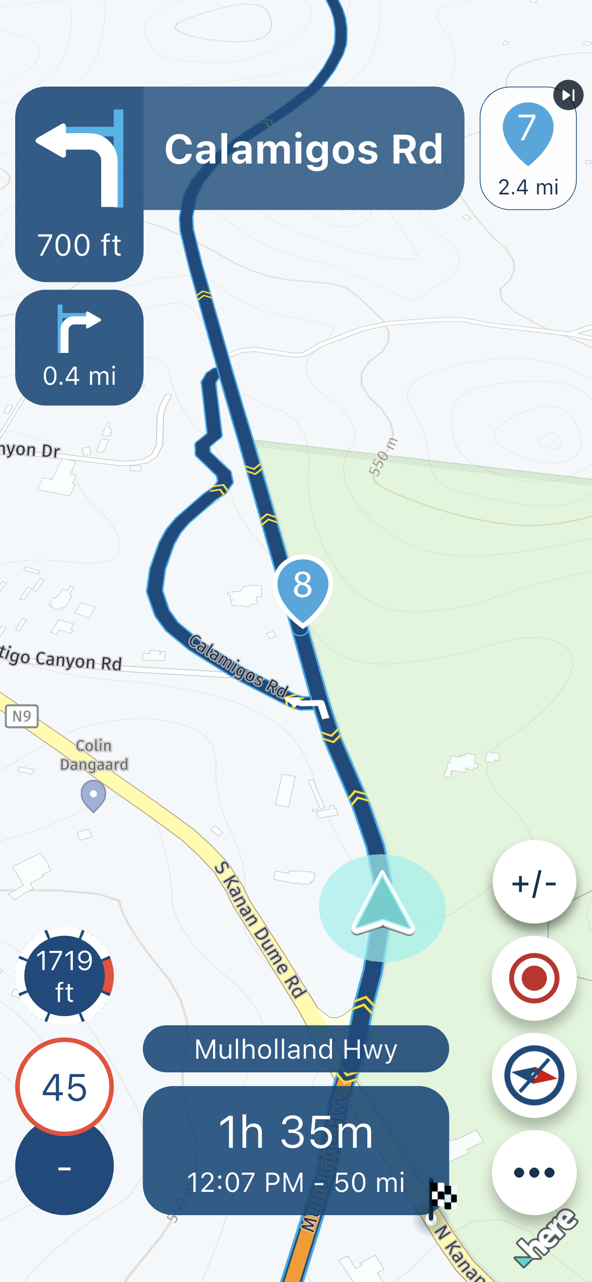
Move your WP's to the corresponding black dots. If you do that, your WP is correct ON the HERE map. No matter the layer you use.
Yes, I am familiar with this procedure and I do it the same way. My actual question is: Which X-Y coordinates are in the GPX files? The coordinates for the blue route points or those for the small black ones on the route? Can you answer that?
@Mopetenpit, That is an intriguing question...
")
I am quite confident that the stored coordinate is the one that represents the WP and not the black dot. That is easily argumented, because the WP comes back at the same place when exporting and re-importing a GPX file. The black dot is a calculated coordinate that fixes the WP coordinate to a routable road.However: because I hate to talk bullshit I actually exported a GPX file to check if not also the black dot coordinate is present in the file.
Each WP seems to be represented by a single coordinate in the route data of the GPX file, but I had some trouble recognizing it. It seems the coordinate in the file has a lot more digits than the ones shown in the WP info in the planner
(red oval)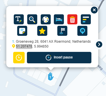
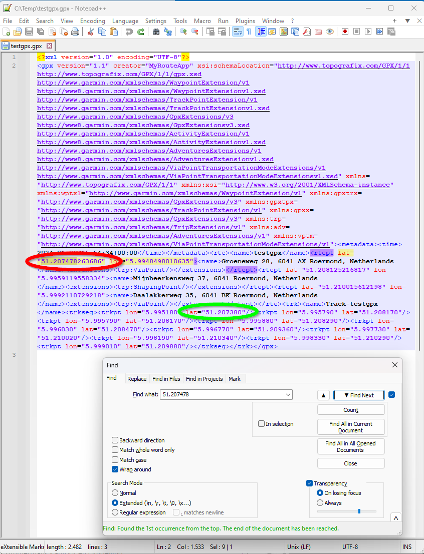
If you look at the Track information in the same file you can see that the first coordinate (green circle) is not equal (besides that LATitude and LONgitude have been flipped? Why...). This is quite logical, since the breadcrum over the routeline is represented, and not the waypoints. I think for at least the first and the last WP of a route the track-coordinate will be exactly the black dot. How the breadcrums in between these point are calculated, I have no idea. But for the start en endpoint I checked them in Google maps and they seem to correspond. Just flip LAT and LON, else you will and up somewhere off the coast of Somalia...

I am just an enthusiastic MRA user, and hope you will be one too!
Most motorcycle problems are caused by the nut that connects the handlebar to the saddle.
Check out RideSleepRepeat.eu, a biker community for sharing stays across Europe
-
@Mopetenpit, That is an intriguing question...
I am quite confident that the stored coordinate is the one that represents the WP and not the black dot. That is easily argumented, because the WP comes back at the same place when exporting and re-importing a GPX file. The black dot is a calculated coordinate that fixes the WP coordinate to a routable road.However: because I hate to talk bullshit I actually exported a GPX file to check if not also the black dot coordinate is present in the file.
Each WP seems to be represented by a single coordinate in the route data of the GPX file, but I had some trouble recognizing it. It seems the coordinate in the file has a lot more digits than the ones shown in the WP info in the planner
(red oval)If you look at the Track information in the same file you can see that the first coordinate (green circle) is not equal (besides that LATitude and LONgitude have been flipped? Why...). This is quite logical, since the breadcrum over the routeline is represented, and not the waypoints. I think for at least the first and the last WP of a route the track-coordinate will be exactly the black dot. How the breadcrums in between these point are calculated, I have no idea. But for the start en endpoint I checked them in Google maps and they seem to correspond. Just flip LAT and LON, else you will and up somewhere off the coast of Somalia...
@Con-Hennekens Lat and Lon aren't actually flipped, just the order in which they happen to be present in the file differs from the routepoint to the trackpoint. For both, lat is still 51.x, while lon is 5.x, so no we're not in Somalia.
And like I said, I don't think there's a black dot at all, just the overlap of two semi-transparent lines. There's no "black dot" at the start of the line.
-
@CD130 Heel vreemd inderdaad. Aantal situaties bij mij in de buurt geprobeerd en daar loopt de route gewoon netjes over de kaart.
Jouw stukje route loopt op geen enkele kaartlaag correct (met HERE als onderlaag), dus wat daar aan de hand is...
@Herko-ter-Horst said in Ben niet blij met de nieuwe HERE kaart!:
Jouw stukje route loopt op geen enkele kaartlaag correct (met HERE als onderlaag), dus wat daar aan de hand is...
Ik verdenk hem ervan dat hij toch stiekem buiten de gebaande paden heeft gereden
🏍️ BMW K1600GT-P (2013) | Nolan N100-5 with Sena 30K
📱 iOS on iPhone 13 & 16 (mounted on Quadlock or AliExpress extention on BMW-cradle)
🚙 Apple CarPlay in VW T-Roc
💻 Routelab on MacBook Air & iMac (Tahoe & Ventura) -
@Herko-ter-Horst said in Ben niet blij met de nieuwe HERE kaart!:
Jouw stukje route loopt op geen enkele kaartlaag correct (met HERE als onderlaag), dus wat daar aan de hand is...
Ik verdenk hem ervan dat hij toch stiekem buiten de gebaande paden heeft gereden
@Con-Hennekens @Herko-ter-Horst @Rob-Verhoeff @CD130
Thank you for the detailed answer to my question!
-
@Con-Hennekens Lat and Lon aren't actually flipped, just the order in which they happen to be present in the file differs from the routepoint to the trackpoint. For both, lat is still 51.x, while lon is 5.x, so no we're not in Somalia.
And like I said, I don't think there's a black dot at all, just the overlap of two semi-transparent lines. There's no "black dot" at the start of the line.
@Herko-ter-Horst said in Ben niet blij met de nieuwe HERE kaart!:
Lat and Lon aren't actually flipped, just the order in which they happen to be present in the file differs from the routepoint to the trackpoint.
Yes of course, the position is flipped. But if you copy the coordinate and paste it in GMaps, remove the non-numbers, of course that will lead to flipped coordinates. But I meant nothing else than that their positions in the file where flipped of course (would be something if it wasn't
)And like I said, I don't think there's a black dot at all, just the overlap of two semi-transparent lines. There's no "black dot" at the start of the line.
You are quite right, but there where line segments overlap we see a....
They still represent the coordinate of a waypoint that is transposed to the actual road. -
@Dwars Dan kan je jezelf nog steeds trakteren op een andere kaart. Selecteer simpel een andere overlay (Michelin, OSM of TomTom) en je kan helemaal los met alle kleurtjes. De hoofdkaart voor de route berekening is dan nog steeds Here (TT of OSM). En aan de wandelpaden of onverharde wegen heb je toch al niets in de Here-kaart omdat de meeste simpelweg ontbreken en de navigatie over dat soort wegverharding niet wordt ondersteund.
@Rob-Verhoeff ik denk dat Dwars bedoeld in de Navigation omgeving.
zou mooi zijn als we zouden kunnen rijden op de OSM kaart maar dat gaat niet voor zover ik weet. -
@Rob-Verhoeff ik denk dat Dwars bedoeld in de Navigation omgeving.
zou mooi zijn als we zouden kunnen rijden op de OSM kaart maar dat gaat niet voor zover ik weet.Nee Rob, je hebt het mis!
Dwars bedoelt de gewone routekaart van HERE die eerst hartstikke duidelijk was maar waarvan nu alle wegen groot of klein dezelfde kleur hebben.
En ik weet dat je daar dan een andere kaart over kunt leggen of wat ik hier boven ook al gelezen heb dat ik dan de waypoints op de zwarte puntjes moet zetten.
Het gaat om de topografische kaart en niet de Navigation kaart. -
Nee Rob, je hebt het mis!
Dwars bedoelt de gewone routekaart van HERE die eerst hartstikke duidelijk was maar waarvan nu alle wegen groot of klein dezelfde kleur hebben.
En ik weet dat je daar dan een andere kaart over kunt leggen of wat ik hier boven ook al gelezen heb dat ik dan de waypoints op de zwarte puntjes moet zetten.
Het gaat om de topografische kaart en niet de Navigation kaart.@Dwars said in Ben niet blij met de nieuwe HERE kaart!:
Nee Rob, je hebt het mis!
Dwars bedoelt... etc.Je bedoelt denk ik @Christian-Zondag
-
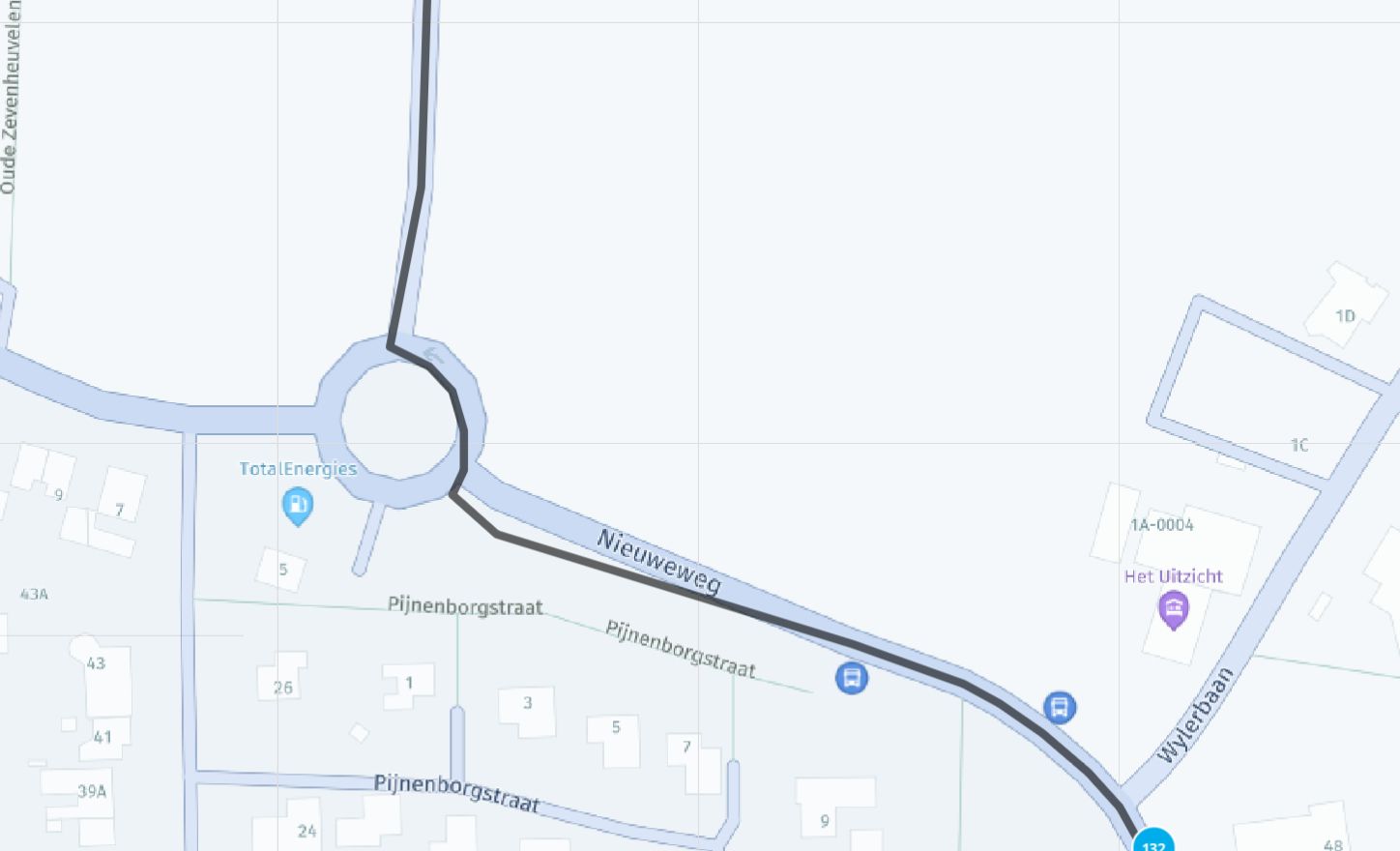
Zo te zien loopt de nieuwe HERE layout ook niet overeen met de daadwerkelijke route gemaakt in HERE… Dat is toch wel een beetje vreemd…
Hier een voorbeeld
-
 undefined CD130 referenced this topic on
-
@Dwars
Hallo,
ich finde das neue Karten Farbbild bei HERE leider auch "mißlungen".
Ich plane meine Routen alle am PC mit MRA und das
alte Kartendesign war von der farblichen Darstellung hierfür
perfekt.
Die unterschiedlichen Straßen waren super zu erkennen und auch farblich unterschiedlich.
Jetzt sind alle Straßen grau und unterscheiden sich nur in der
Breite. Dazu sind sie noch auf dem blassen Untergrund
schwer zu erkennen.
Es wäre eine gute Sache, wenn zu den vorhandenen Karten auch noch das "alte" Here Kartendesign zur Verfügung steht.
Hinzu kommt ja auch noch , das auf meinem Navi auch das
alte Kartendesign angezeigt wird.
Ich glaube auch nicht, das bei meinem Garmin Navi beim nächsten
Update euer neues Kartenlayout erscheint.
Also wird es die alte HERE Karte weiter geben, eben nur nicht
bei MRA.
In der APP ist es ja auch möglich, die Karte HERE "Gold" zu
wählen.
Die alte HERE Karte wird also nicht vom Markt verschwinden.
Was wäre das für ein Chaos, wenn Papier Karten ein solches Kartenbild bekämen.
Wer soll da noch den richtigen Weg finden.
Leider verliert MRA durch die Umstellung an viel Interesse und
Attraktivität für die Anwender.
Ich glaube, die Entwickler haben noch nie selbst eine Touren-
planung gemacht.
Auch wenn das alte HERE nicht weiter gepflegt würde, könnte man es doch als Karte erhalten. -
@Dwars
Hallo,
ich finde das neue Karten Farbbild bei HERE leider auch "mißlungen".
Ich plane meine Routen alle am PC mit MRA und das
alte Kartendesign war von der farblichen Darstellung hierfür
perfekt.
Die unterschiedlichen Straßen waren super zu erkennen und auch farblich unterschiedlich.
Jetzt sind alle Straßen grau und unterscheiden sich nur in der
Breite. Dazu sind sie noch auf dem blassen Untergrund
schwer zu erkennen.
Es wäre eine gute Sache, wenn zu den vorhandenen Karten auch noch das "alte" Here Kartendesign zur Verfügung steht.
Hinzu kommt ja auch noch , das auf meinem Navi auch das
alte Kartendesign angezeigt wird.
Ich glaube auch nicht, das bei meinem Garmin Navi beim nächsten
Update euer neues Kartenlayout erscheint.
Also wird es die alte HERE Karte weiter geben, eben nur nicht
bei MRA.
In der APP ist es ja auch möglich, die Karte HERE "Gold" zu
wählen.
Die alte HERE Karte wird also nicht vom Markt verschwinden.
Was wäre das für ein Chaos, wenn Papier Karten ein solches Kartenbild bekämen.
Wer soll da noch den richtigen Weg finden.
Leider verliert MRA durch die Umstellung an viel Interesse und
Attraktivität für die Anwender.
Ich glaube, die Entwickler haben noch nie selbst eine Touren-
planung gemacht.
Auch wenn das alte HERE nicht weiter gepflegt würde, könnte man es doch als Karte erhalten.@Helmut-Müller said in Ben niet blij met de nieuwe HERE kaart!:
Ich glaube, die Entwickler haben noch nie selbst eine Touren-
planung gemacht. And now seriously: There is a difference between the HERE maps from HERE and the HERE maps from Garmin. Garmin adds their own details on a seperate (probably self-hosted) platform. MRA makes use of the fixed HERE platform. I agree with you that the new map-style lacks detail (to be honest, I thought likewise about the old style HERE map). Luckily we have maplayers for this. And hopefully HERE will turn on their design decisions. I don't think it is much in MRAs hands.
-
@Dwars
Hallo,
ich finde das neue Karten Farbbild bei HERE leider auch "mißlungen".
Ich plane meine Routen alle am PC mit MRA und das
alte Kartendesign war von der farblichen Darstellung hierfür
perfekt.
Die unterschiedlichen Straßen waren super zu erkennen und auch farblich unterschiedlich.
Jetzt sind alle Straßen grau und unterscheiden sich nur in der
Breite. Dazu sind sie noch auf dem blassen Untergrund
schwer zu erkennen.
Es wäre eine gute Sache, wenn zu den vorhandenen Karten auch noch das "alte" Here Kartendesign zur Verfügung steht.
Hinzu kommt ja auch noch , das auf meinem Navi auch das
alte Kartendesign angezeigt wird.
Ich glaube auch nicht, das bei meinem Garmin Navi beim nächsten
Update euer neues Kartenlayout erscheint.
Also wird es die alte HERE Karte weiter geben, eben nur nicht
bei MRA.
In der APP ist es ja auch möglich, die Karte HERE "Gold" zu
wählen.
Die alte HERE Karte wird also nicht vom Markt verschwinden.
Was wäre das für ein Chaos, wenn Papier Karten ein solches Kartenbild bekämen.
Wer soll da noch den richtigen Weg finden.
Leider verliert MRA durch die Umstellung an viel Interesse und
Attraktivität für die Anwender.
Ich glaube, die Entwickler haben noch nie selbst eine Touren-
planung gemacht.
Auch wenn das alte HERE nicht weiter gepflegt würde, könnte man es doch als Karte erhalten.@Helmut-Müller said in Ben niet blij met de nieuwe HERE kaart!:
Ich glaube, die Entwickler haben noch nie selbst eine Touren-
planung gemacht.Are you serious?
🏍️ BMW K1600GT-P (2013) | Nolan N100-5 with Sena 30K
📱 iOS on iPhone 13 & 16 (mounted on Quadlock or AliExpress extention on BMW-cradle)
🚙 Apple CarPlay in VW T-Roc
💻 Routelab on MacBook Air & iMac (Tahoe & Ventura) -
@Helmut-Müller said in Ben niet blij met de nieuwe HERE kaart!:
Ich glaube, die Entwickler haben noch nie selbst eine Touren-
planung gemacht.Are you serious?
@Rob-Verhoeff
und wie !
Es geht nicht um die Planung von A nach B.
Es geht um die sehr detailierte Planung von Touren anhand
der Karte. Dabei muß ich erkennen können, ob es ein Weg oder eine Straße ist.Und sie muß auch als solches zu erkennen sein.
Vergleiche doch nur mal die Michelin Karte mit der Here.
Da bedarf es dann schon keiner weiteren Erklärung
VG -
@Rob-Verhoeff
und wie !
Es geht nicht um die Planung von A nach B.
Es geht um die sehr detailierte Planung von Touren anhand
der Karte. Dabei muß ich erkennen können, ob es ein Weg oder eine Straße ist.Und sie muß auch als solches zu erkennen sein.
Vergleiche doch nur mal die Michelin Karte mit der Here.
Da bedarf es dann schon keiner weiteren Erklärung
VG@Helmut-Müller Let me put it delicately... the lead developer may not be that old, but he knows a whole lot about planning routes!
-
@Dwars
Hallo,
ich finde das neue Karten Farbbild bei HERE leider auch "mißlungen".
Ich plane meine Routen alle am PC mit MRA und das
alte Kartendesign war von der farblichen Darstellung hierfür
perfekt.
Die unterschiedlichen Straßen waren super zu erkennen und auch farblich unterschiedlich.
Jetzt sind alle Straßen grau und unterscheiden sich nur in der
Breite. Dazu sind sie noch auf dem blassen Untergrund
schwer zu erkennen.
Es wäre eine gute Sache, wenn zu den vorhandenen Karten auch noch das "alte" Here Kartendesign zur Verfügung steht.
Hinzu kommt ja auch noch , das auf meinem Navi auch das
alte Kartendesign angezeigt wird.
Ich glaube auch nicht, das bei meinem Garmin Navi beim nächsten
Update euer neues Kartenlayout erscheint.
Also wird es die alte HERE Karte weiter geben, eben nur nicht
bei MRA.
In der APP ist es ja auch möglich, die Karte HERE "Gold" zu
wählen.
Die alte HERE Karte wird also nicht vom Markt verschwinden.
Was wäre das für ein Chaos, wenn Papier Karten ein solches Kartenbild bekämen.
Wer soll da noch den richtigen Weg finden.
Leider verliert MRA durch die Umstellung an viel Interesse und
Attraktivität für die Anwender.
Ich glaube, die Entwickler haben noch nie selbst eine Touren-
planung gemacht.
Auch wenn das alte HERE nicht weiter gepflegt würde, könnte man es doch als Karte erhalten. -
@Rob-Verhoeff
und wie !
Es geht nicht um die Planung von A nach B.
Es geht um die sehr detailierte Planung von Touren anhand
der Karte. Dabei muß ich erkennen können, ob es ein Weg oder eine Straße ist.Und sie muß auch als solches zu erkennen sein.
Vergleiche doch nur mal die Michelin Karte mit der Here.
Da bedarf es dann schon keiner weiteren Erklärung
VG@Helmut-Müller said in Ben niet blij met de nieuwe HERE kaart!:
Vergleiche doch nur mal die Michelin Karte mit der Here.
Da bedarf es dann schon keiner weiteren ErklärungApparently it does need some extra explanation:
You can activate the Michelin map-overlay on top of the HERE map.
That is an very welcome feature, programmed by the developer, who very well knows what it takes to plan routes...I am just an enthusiastic MRA user, and hope you will be one too!
Most motorcycle problems are caused by the nut that connects the handlebar to the saddle.
Check out RideSleepRepeat.eu, a biker community for sharing stays across Europe
-
@Helmut-Müller said in Ben niet blij met de nieuwe HERE kaart!:
Vergleiche doch nur mal die Michelin Karte mit der Here.
Da bedarf es dann schon keiner weiteren ErklärungApparently it does need some extra explanation:
You can activate the Michelin map-overlay on top of the HERE map.
That is an very welcome feature, programmed by the developer, who very well knows what it takes to plan routes...@Con-Hennekens said in Ben niet blij met de nieuwe HERE kaart!:
You can activate the Michelin map-overlay on top of the HERE map.
That is an very welcome feature, programmed by the developer, who very well knows what it takes to plan routes..All very true, but it does not change that HERE (on which MRA is totally dependent) seems not to be an entirely satisfactory product.
Just look how many negative posts there are about Here, not to mention the battery drain issue
It is not difficult, it is easy, it's a hobby
-
@Con-Hennekens said in Ben niet blij met de nieuwe HERE kaart!:
You can activate the Michelin map-overlay on top of the HERE map.
That is an very welcome feature, programmed by the developer, who very well knows what it takes to plan routes..All very true, but it does not change that HERE (on which MRA is totally dependent) seems not to be an entirely satisfactory product.
Just look how many negative posts there are about Here, not to mention the battery drain issue
@Drabslab, no it is not, but I never said it was
-
@Rob-Verhoeff
und wie !
Es geht nicht um die Planung von A nach B.
Es geht um die sehr detailierte Planung von Touren anhand
der Karte. Dabei muß ich erkennen können, ob es ein Weg oder eine Straße ist.Und sie muß auch als solches zu erkennen sein.
Vergleiche doch nur mal die Michelin Karte mit der Here.
Da bedarf es dann schon keiner weiteren Erklärung
VG@Helmut-Müller
Ich versuche es mal mit einer kleinen Nachricht an here
Hello! It looks like you're interested in this conversation, but you don't have an account yet.
Getting fed up of having to scroll through the same posts each visit? When you register for an account, you'll always come back to exactly where you were before, and choose to be notified of new replies (either via email, or push notification). You'll also be able to save bookmarks and upvote posts to show your appreciation to other community members.
With your input, this post could be even better 💗
Register Login-
0546.4k
-
07102
-
023653
-
0443
-
17238.5k
-
1875.9k
-
07116
-
0233