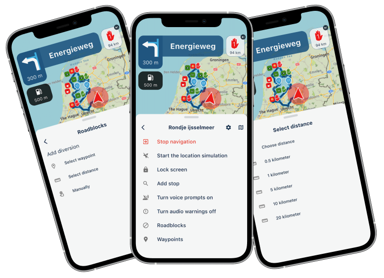
Ability to tell differance between waypoints and destinations
-
Tyre was amazing at doing this, you could (can) design a route and with older sat navs they announce just the upcoming destinations like fuel stops, lunch stops, rest stops and hotels and give you a distance to next destination. The ability to do this in paramount in designing a good route. The waypoints are of no interest to motorist they simply keep the device on track its the destinations along the way thats important and how far apart they are from each other. Tyre can do all of this My Route cannot.
-
I agree. This is common even in Basecamp. You can easily change between a "shaping point" which does NOT announce and a "waypoint" which does announce. But you have to go through the waypoint or it will keep trying to re-route you BACK to that waypoint that the system thinks you missed, where the shaping point lets just blow by and on to the next.
In my VERY LIMITED experience with MRA we create "shaping points" in Garmin parlance.
"There is no problem so bad that you can't make it worse"
- Chris Hadfield (NASA Astronaut)
-
I agree. This is common even in Basecamp. You can easily change between a "shaping point" which does NOT announce and a "waypoint" which does announce. But you have to go through the waypoint or it will keep trying to re-route you BACK to that waypoint that the system thinks you missed, where the shaping point lets just blow by and on to the next.
In my VERY LIMITED experience with MRA we create "shaping points" in Garmin parlance.
@Greenham No, we create WPs in MRA, not shaping points. In fact I wish I knew how to create a shaping point using MRA, so as not to be compelled to route past if. The only way I know of creating a shaping point is by way of the very tedious, time consuming and error prone method of using the satnav editor.
-
Hello,
may I jump on this topic and switch over to this issue on my Garmin Zumo 390.
As the Zumo has the function to skip the next waypoint (shown as a flag on the map) in case of e.g. a construction caused detour, I need to export the track out of MPA with such waypoints (flags) and not with such "shaping points" (shown as simple dots) which I cannot skip. Zumo also does not simply ignore these MPA Points when passing by such location, so it seems to be not the typical Garmin/BaseCamp shaping point either....!?!?My current work around: I have to load the whole route as new, delete all the points I have passed yet and recalculate the route as new again.... This sounds simple but is mostly hair rising...!
What is your experience when transferring a route to the Zumo?
Many thanks.
Andi -
My original point is if your'e going to discontinue a very good working platform in favour of a newer version at the very least make it as good as or better than its predecessor. My Route is a very poor replacement and lacks the basic requirement of sat nav navigation, apart from the massive loss I mentioned above you cant even rename waypoints in your route design as latest tom tom devices doesn't recognise them.
Please someone from MyRoute reply and justify the lack of basic facilities you've omitted.
-
Hello,
may I jump on this topic and switch over to this issue on my Garmin Zumo 390.
As the Zumo has the function to skip the next waypoint (shown as a flag on the map) in case of e.g. a construction caused detour, I need to export the track out of MPA with such waypoints (flags) and not with such "shaping points" (shown as simple dots) which I cannot skip. Zumo also does not simply ignore these MPA Points when passing by such location, so it seems to be not the typical Garmin/BaseCamp shaping point either....!?!?My current work around: I have to load the whole route as new, delete all the points I have passed yet and recalculate the route as new again.... This sounds simple but is mostly hair rising...!
What is your experience when transferring a route to the Zumo?
Many thanks.
Andi@Andreas-1o After importing such a route In BaseCamp, you can convert all these route-composing waypoints (alerting you when passing along the point) into (what is called here) "shaping" points (NOT alerting you when passing along it). How ? Select all these points, right-click, and select "do not alert" (or something like it in BaseCamp's English version). You shouldn't delete them ?!
-
Hello,
may I jump on this topic and switch over to this issue on my Garmin Zumo 390.
As the Zumo has the function to skip the next waypoint (shown as a flag on the map) in case of e.g. a construction caused detour, I need to export the track out of MPA with such waypoints (flags) and not with such "shaping points" (shown as simple dots) which I cannot skip. Zumo also does not simply ignore these MPA Points when passing by such location, so it seems to be not the typical Garmin/BaseCamp shaping point either....!?!?My current work around: I have to load the whole route as new, delete all the points I have passed yet and recalculate the route as new again.... This sounds simple but is mostly hair rising...!
What is your experience when transferring a route to the Zumo?
Many thanks.
Andi@Andreas-1o
I have same probs by using MRA and loading routes to Garmin 396.
On long trips, I do route planning with MRA on my Tablet (Android), which is more comfortable than doing direct on Garmin device.
But if I load routes from Tablet to Garmin, waypoints from MRA are no longer waypoints in Garmin; they became shaping ponts!
The only way to correct this is to open the route on Garmin, change every single shaping point into an waypoint and just the start the route.Please develop a solution in MRA to get select option for a routing point, to be a way point or shaping point. Or make every routing point to a waypoint, bevause Garmins devices have the option to sikp next waypoint during routing.
-
@Andreas-1o After importing such a route In BaseCamp, you can convert all these route-composing waypoints (alerting you when passing along the point) into (what is called here) "shaping" points (NOT alerting you when passing along it). How ? Select all these points, right-click, and select "do not alert" (or something like it in BaseCamp's English version). You shouldn't delete them ?!
@sudolea
Please See my replay before. BaseCamp is not always present. Changes then mußt be done in Garmin device, which is an ugly way.

Hello! It looks like you're interested in this conversation, but you don't have an account yet.
Getting fed up of having to scroll through the same posts each visit? When you register for an account, you'll always come back to exactly where you were before, and choose to be notified of new replies (either via email, or push notification). You'll also be able to save bookmarks and upvote posts to show your appreciation to other community members.
With your input, this post could be even better 💗
Register Login-
024419
-
012263
-
27371.9k
-
06134
-
05935.1k
-
0352
-
111656
-
19242