MRA Routeplanner using by default gravel roads
-
I've got Here Map (not layer) 'couse I'm Navigator life and when I use Here map I can't use any avoid. The Web tells me that I must be "gold user" to use Toolbox

Is that a bug on planner?
Regards
Lluis Arasanz
- BMW F750GS
MotoMediaLink HW Interface for BMW's WonderWheel device - Samsung A14 with Beta MyRoute-App (primary bike use)
Tasker and MMLink SW for Android App Control - iPhone 14 with Beta MyRoute-App (personal and primary CP use)
- BMW F750GS
-
I've got Here Map (not layer) 'couse I'm Navigator life and when I use Here map I can't use any avoid. The Web tells me that I must be "gold user" to use Toolbox
Is that a bug on planner?
Regards
@Lluis-Arasanz said in MRA Routeplanner using by default gravel roads:
I've got Here Map (not layer) 'couse I'm Navigator life and when I use Here map I can't use any avoid. The Web tells me that I must be "gold user" to use Toolbox
Is that a bug on planner?
Regards
If you are using the HERE planning map you will have access to the avoid tools.
The HERE planning map is available for Gold and Nav users. See my screenshot.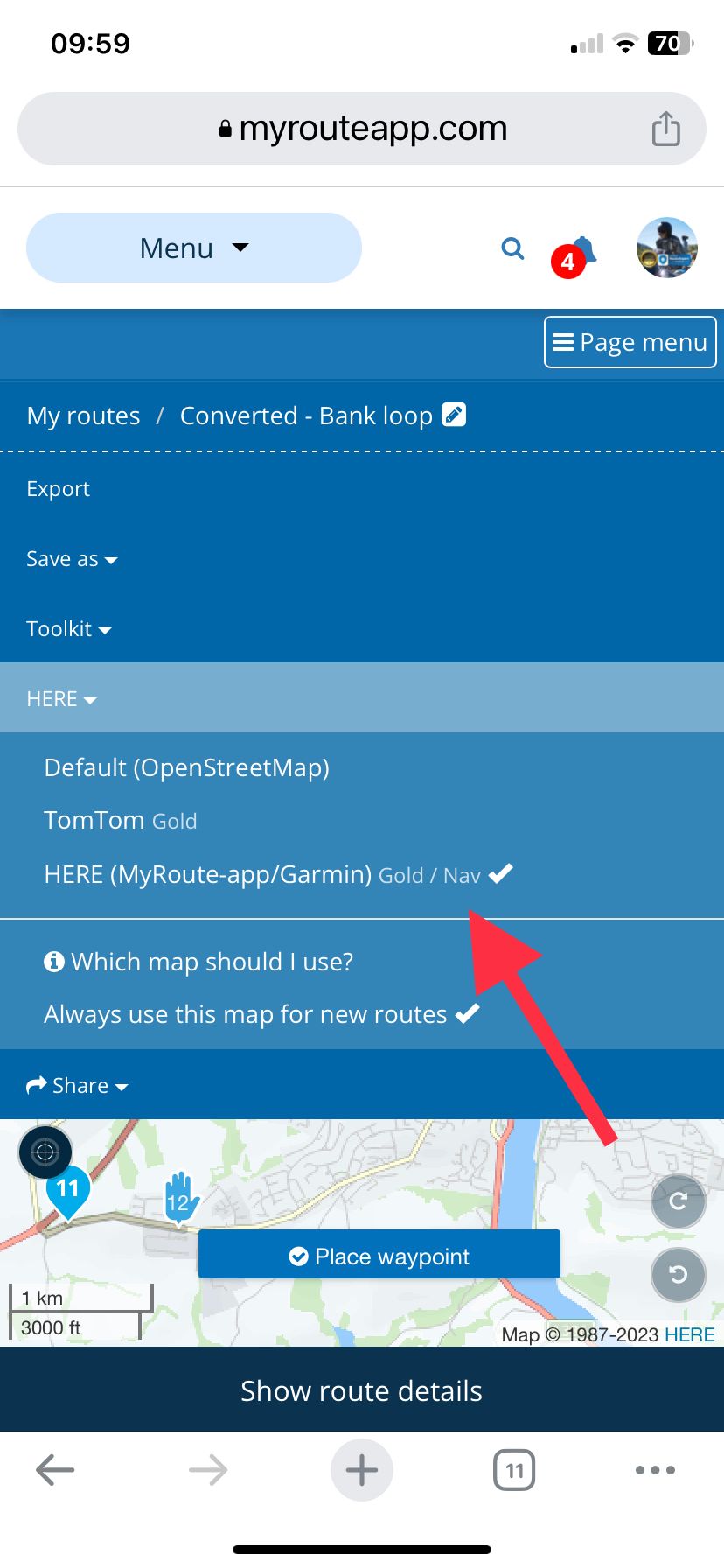
-
Yes, I have access and use Here Map, but if I want to use avoid in "toolbox", at the moment I select "avoid tunnels" (as a example), then the planner indicate me that this is a gold feature and is necessary a suscription. This happens for any of items inside avoid when using Here Map.
If I use Openstreet map, then the features works fine.
So... I'va got access to Here map but not to Here avoid features.
Regards
Lluis Arasanz
- BMW F750GS
MotoMediaLink HW Interface for BMW's WonderWheel device - Samsung A14 with Beta MyRoute-App (primary bike use)
Tasker and MMLink SW for Android App Control - iPhone 14 with Beta MyRoute-App (personal and primary CP use)
- BMW F750GS
-
Yes, I have access and use Here Map, but if I want to use avoid in "toolbox", at the moment I select "avoid tunnels" (as a example), then the planner indicate me that this is a gold feature and is necessary a suscription. This happens for any of items inside avoid when using Here Map.
If I use Openstreet map, then the features works fine.
So... I'va got access to Here map but not to Here avoid features.
Regards
@Lluis-Arasanz Please forgive me, I have made a mistake. Your Navigation subscription gives you access to the HERE map but not all of the HERE tools.
You can see and compare what each subscription has in the MRA shop.
-
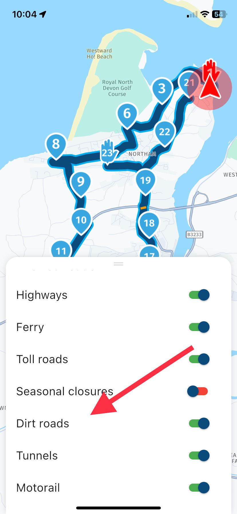
@Thomas-Scharrer Also in the app. When you have a route loaded for navigation, before you press the Start button, scroll up to see Allowed roads and un-select Dirt roads.
@Nick-Carthew I have tested now a little the HERE map for planning routes and yes it is better with respect to recognising gravel roads but otherwise I see unfortunately only disadvantages with this map compared to google maps because it is just a lot more basic. For example it cannot even find or recognise a gas station, meaning you are not able to search for s specific gas station with it. As you can see in the below picture compared to google maps, obviously it doesnt even now this gas station exists there.
I think I will soon give up with MRA or maybe start again in a couple of years when it is more useful. For motor bike trips I can anyway not use it since voice guidance is not working and my car has google maps implemented so its jut a lot more complicated and inconvenient to use MRA. It is still a good route planner with google maps map though
-
@Nick-Carthew I have tested now a little the HERE map for planning routes and yes it is better with respect to recognising gravel roads but otherwise I see unfortunately only disadvantages with this map compared to google maps because it is just a lot more basic. For example it cannot even find or recognise a gas station, meaning you are not able to search for s specific gas station with it. As you can see in the below picture compared to google maps, obviously it doesnt even now this gas station exists there.
I think I will soon give up with MRA or maybe start again in a couple of years when it is more useful. For motor bike trips I can anyway not use it since voice guidance is not working and my car has google maps implemented so its jut a lot more complicated and inconvenient to use MRA. It is still a good route planner with google maps map though
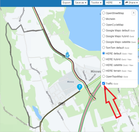
@Thomas-Scharrer This is why the overlay maps are available to use. Plan on the HERE map and switch between different overlay maps. Google is good for finding Cafes, restaurants, fuel stations etc. Michelin has the scenic roads indicated by a green line. OpenStreetMap has an incredible amount of detail when you zoom in, especially in towns and cities and you can see different types of roads including gravel roads.
Don’t give up, just invest a little more time in getting to know all of the tools and maps to use. There is no better RoutePlanner than MRA.Always willing to help if I can.
Triumph Tiger 1200 XRT called Tina.
MRA Navigation Next and SilverFox BJ8 -
@Thomas-Scharrer This is why the overlay maps are available to use. Plan on the HERE map and switch between different overlay maps. Google is good for finding Cafes, restaurants, fuel stations etc. Michelin has the scenic roads indicated by a green line. OpenStreetMap has an incredible amount of detail when you zoom in, especially in towns and cities and you can see different types of roads including gravel roads.
Don’t give up, just invest a little more time in getting to know all of the tools and maps to use. There is no better RoutePlanner than MRA.@Nick-Carthew thanks for encouraging me not to give up. I have tried hard the last couple of weeks to stay positive and use the HERE map for route planning.
Unfortunately I have to say that the HERE map is not working at all for me and I am seriously loosing it with this map. It might be that this map works well in central Europa but here in Scandinavia its just not usable at all.
The reason why it is not usable is because its cannot connect tow way points as you want them to be connected to create your desired route.
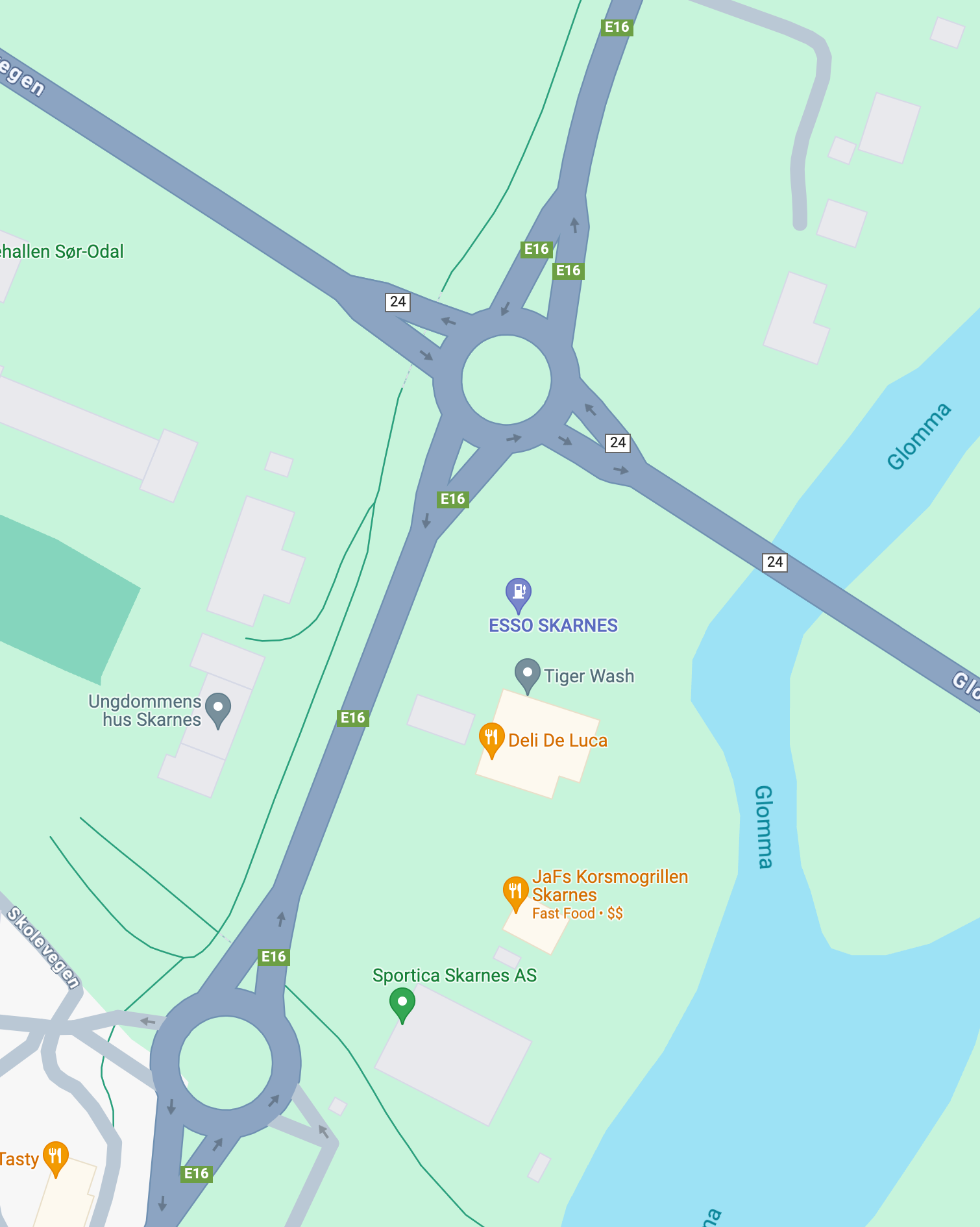
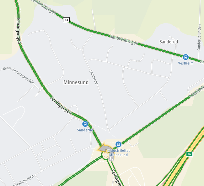
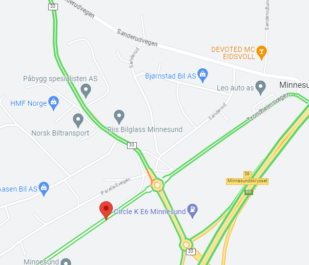
Here the explanation, please note that I had many cases like this when I used the HERE map but I am showing here only one example.
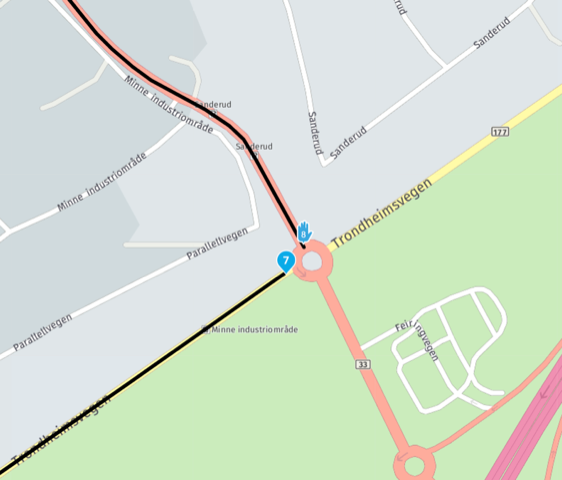
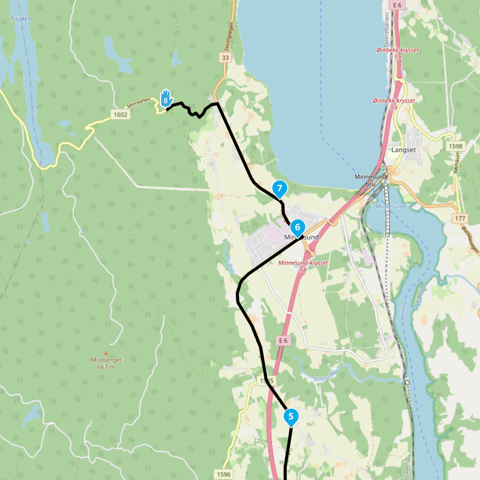
Picture 1: shows that the point 6 and 7 are very close together but the HERE map will NOT connect them and finds long ways to drive around.
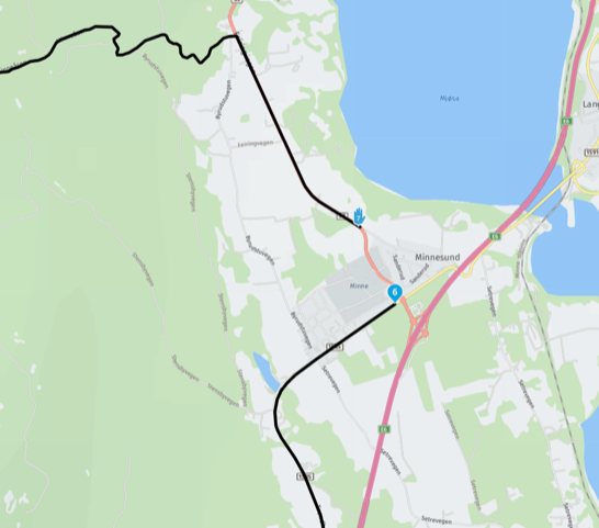
Picture 2: is just a zoomed detail view to show the problem. As you can see there are only some meters between these points.
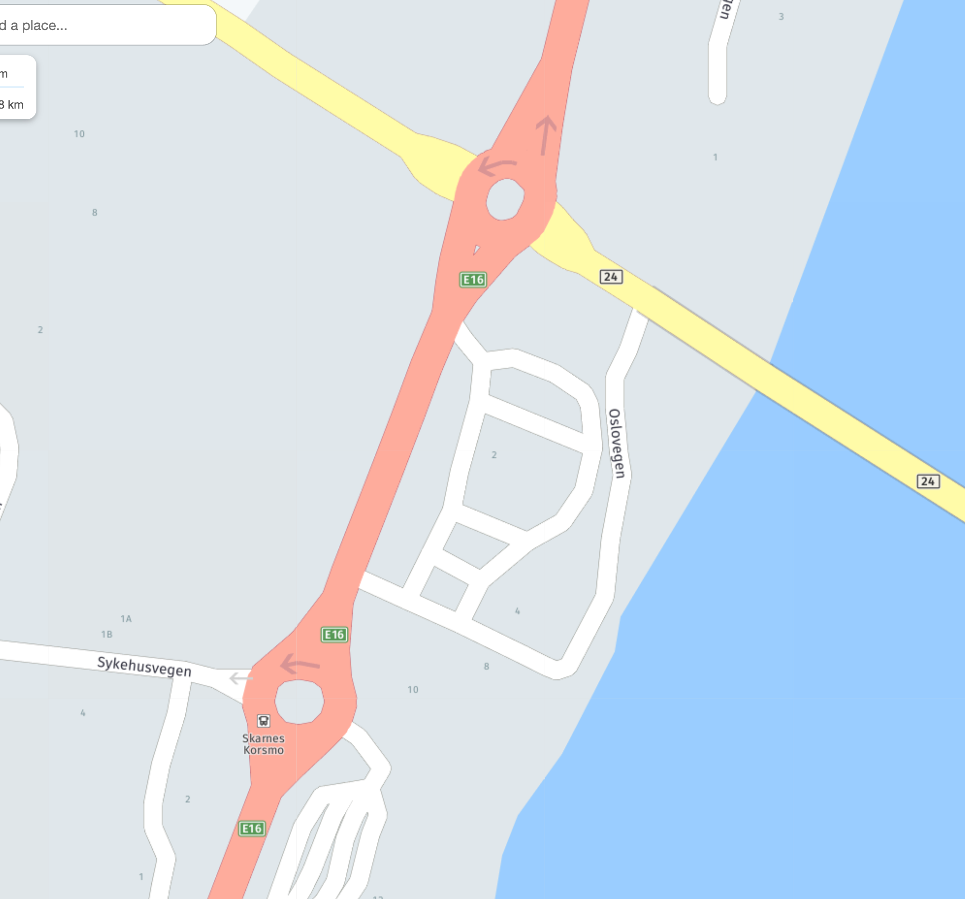
Picture 3: shows what happens when you switch to open street map. It immediately and automatically connects the the two points as it should be. However when switching back to the HERE map it is messed up again.
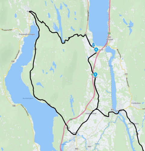
This is the reason why I am not able to use the HERE map for route planning, this is crazy.Picture 4: shows that you can actually move these points together extremely close but it will still not connect them and will find the craziest ways to drive around.
I guess you will argue now (as defence) that this specific piece of road is a gravel road and I have selected to avoid gravel roads but that is not the case. I have been there before and I can assure that this is not a gravel road. I can also send proof from google street view if you like.
So unfortunately my conclusion is:
- Either you accept to have some gravel roads in you tours but you are actually able to plan tours with open street map
- or you dont have gravel roads but you have totally crazy and unusable route planning system.
EDIT: please note that the pictures ended up in opposite order
-
@Nick-Carthew thanks for encouraging me not to give up. I have tried hard the last couple of weeks to stay positive and use the HERE map for route planning.
Unfortunately I have to say that the HERE map is not working at all for me and I am seriously loosing it with this map. It might be that this map works well in central Europa but here in Scandinavia its just not usable at all.
The reason why it is not usable is because its cannot connect tow way points as you want them to be connected to create your desired route.
Here the explanation, please note that I had many cases like this when I used the HERE map but I am showing here only one example.
Picture 1: shows that the point 6 and 7 are very close together but the HERE map will NOT connect them and finds long ways to drive around.
Picture 2: is just a zoomed detail view to show the problem. As you can see there are only some meters between these points.
Picture 3: shows what happens when you switch to open street map. It immediately and automatically connects the the two points as it should be. However when switching back to the HERE map it is messed up again.
This is the reason why I am not able to use the HERE map for route planning, this is crazy.Picture 4: shows that you can actually move these points together extremely close but it will still not connect them and will find the craziest ways to drive around.
I guess you will argue now (as defence) that this specific piece of road is a gravel road and I have selected to avoid gravel roads but that is not the case. I have been there before and I can assure that this is not a gravel road. I can also send proof from google street view if you like.
So unfortunately my conclusion is:
- Either you accept to have some gravel roads in you tours but you are actually able to plan tours with open street map
- or you dont have gravel roads but you have totally crazy and unusable route planning system.
EDIT: please note that the pictures ended up in opposite order
@Thomas-Scharrer Are you using the HERE planning map?
When I replicate your route I do not see a problem.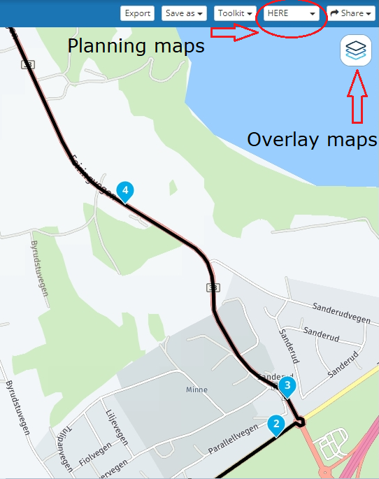
Always willing to help if I can.
Triumph Tiger 1200 XRT called Tina.
MRA Navigation Next and SilverFox BJ8 -
@Thomas-Scharrer Are you using the HERE planning map?
When I replicate your route I do not see a problem.@Nick-Carthew yes I am using the HERE planning Planning map, that is the whole problem. If I change the planning map to open street map it works perfectly fine.
Maybe this is then some bug only I am experiencing but I had similar cases quite often now when I forced myself to use the HERE map as planning map.
It seems that in my here map it doesnt recognise that this is a possible turn so its always trying to avoid it
-
@Nick-Carthew yes I am using the HERE planning Planning map, that is the whole problem. If I change the planning map to open street map it works perfectly fine.
Maybe this is then some bug only I am experiencing but I had similar cases quite often now when I forced myself to use the HERE map as planning map.
It seems that in my here map it doesnt recognise that this is a possible turn so its always trying to avoid it
@Thomas-Scharrer Can you share this route with me please and I might be able to find a solution.
Always willing to help if I can.
Triumph Tiger 1200 XRT called Tina.
MRA Navigation Next and SilverFox BJ8 -
@Thomas-Scharrer Can you share this route with me please and I might be able to find a solution.
@Nick-Carthew I had deleted this route because I never managed to create it. I tried now to recreate the same and for some unexplainable reason it worked now in this position even though I tried everything before to make this work without success. Maybe there has come an update on the HERE map since I tried to create it?
I will let you know when I notice the next case like this
-
@Nick-Carthew I had deleted this route because I never managed to create it. I tried now to recreate the same and for some unexplainable reason it worked now in this position even though I tried everything before to make this work without success. Maybe there has come an update on the HERE map since I tried to create it?
I will let you know when I notice the next case like this
@Thomas-Scharrer It could have been a road closure that affected your route when you first planned it.
Always willing to help if I can.
Triumph Tiger 1200 XRT called Tina.
MRA Navigation Next and SilverFox BJ8 -
@Thomas-Scharrer It could have been a road closure that affected your route when you first planned it.
@Nick-Carthew thats hard to believe but I have no other explanation. You can see from my screenshots that it was impossible to to connect these two points
-
@Nick-Carthew thats hard to believe but I have no other explanation. You can see from my screenshots that it was impossible to to connect these two points
@Nick-Carthew I tried one more time because I felt totally stupid and now it happened again, here is the shared route
https://www.myrouteapp.com/en/social/route/8241032?mode=share
feel free to switch between the HERE map and the open map
-
@Nick-Carthew I tried one more time because I felt totally stupid and now it happened again, here is the shared route
https://www.myrouteapp.com/en/social/route/8241032?mode=share
feel free to switch between the HERE map and the open map
@Thomas-Scharrer Interesting. The route that I made has now changed and looks like yours now. If I turn the traffic overlay on it shows a black line to indicate a road closure.
I checked this on the TomTom MyDrive website and on Google maps and neither of them show a road closure. Just some roadworks on the roundabout.
The route is ok again if you use the Disable Seasonal Closures tool.
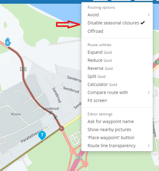
I know that this isn't the perfect solution but it works.
You can report road problems directly to the HERE map using this link: https://mapfeedback.here.com/#/report
I have already reported it but the more people that report it then the more likely that HERE will do something about it.Always willing to help if I can.
Triumph Tiger 1200 XRT called Tina.
MRA Navigation Next and SilverFox BJ8 -
@Thomas-Scharrer Interesting. The route that I made has now changed and looks like yours now. If I turn the traffic overlay on it shows a black line to indicate a road closure.
I checked this on the TomTom MyDrive website and on Google maps and neither of them show a road closure. Just some roadworks on the roundabout.
The route is ok again if you use the Disable Seasonal Closures tool.
I know that this isn't the perfect solution but it works.
You can report road problems directly to the HERE map using this link: https://mapfeedback.here.com/#/report
I have already reported it but the more people that report it then the more likely that HERE will do something about it.@Nick-Carthew thanks a lot for looking into this, I thought already I am crazy.
I will experiment with this seasonal closure feature and the traffic overlay on some of my routes where I had such issues. -
I think it is not very handy that the seasonal closures also handle the maintenance closures. Especially when you live in an area where REAL seasonal closures are no issue, the function poses more problems than they solve. It would be great if these two things could be split, but I guess that they are handled also by HERE as one thing. Maybe it is better to rename this function to "Temporary road closures", and skip the seasonal part.
I am just an enthusiastic MRA user, and hope you will be one too!
Most motorcycle problems are caused by the nut that connects the handlebar to the saddle.
Check out RideSleepRepeat.eu, a biker community for sharing stays across Europe
-
I think it is not very handy that the seasonal closures also handle the maintenance closures. Especially when you live in an area where REAL seasonal closures are no issue, the function poses more problems than they solve. It would be great if these two things could be split, but I guess that they are handled also by HERE as one thing. Maybe it is better to rename this function to "Temporary road closures", and skip the seasonal part.
@Con-Hennekens I don’t think that there is a temporary road closure at this location. I checked two other maps and did an internet search. The problem lies with the HERE map not the Seasonal Closures tool. All we can do as a community is keep reporting these problems.
-
@Nick-Carthew, yes, but the other sources could be wrong too. I don't think it is wise to claim changes by anyone then someone who has seen the situation at hand himself.
But what I really meant is that Seasonable closures are principally different from temporary maintenance closures. It deserves a specific category. If I choose to disable temporary maintenance closure, it is odd that I could be let over a snowey mountain pass or vice versa. Also there is nothing seasonal about maintenance road closures. But yes, probably only whishful thinking on my part
")
I am just an enthusiastic MRA user, and hope you will be one too!
Most motorcycle problems are caused by the nut that connects the handlebar to the saddle.
Check out RideSleepRepeat.eu, a biker community for sharing stays across Europe
-
@Nick-Carthew, yes, but the other sources could be wrong too. I don't think it is wise to claim changes by anyone then someone who has seen the situation at hand himself.
But what I really meant is that Seasonable closures are principally different from temporary maintenance closures. It deserves a specific category. If I choose to disable temporary maintenance closure, it is odd that I could be let over a snowey mountain pass or vice versa. Also there is nothing seasonal about maintenance road closures. But yes, probably only whishful thinking on my part
@Con-Hennekens
@Nick-Carthew
I have checked now several of my routes which were totally messed up when using the HERE map and I have to say I am happy again because it seems the seasonal closure function is the only reason for all the mess.I my opinion there is something wrong in general with this function because I had such issues as described above quite often with the here map and now having disabled this function no problem anymore.
Regarding the specific example above, I can assure you that that this road is not even closed, meaning this is not a full road closure and for sure not a seasonal one. I have also checked the official traffic information from the norwegian traffic department and there is nothing mentioned for this road with respect to closure etc. whihc means the road is open.
Based on this I would suggest to just forget about the seasonal closure function for the time being because without that everything seems to work. Maybe later the function will be improved but I can live without it. In nOrway we have seasonal closures for mountain roads etc so its much more reliable to check for those the official norwegian sources I think.
Hello! It looks like you're interested in this conversation, but you don't have an account yet.
Getting fed up of having to scroll through the same posts each visit? When you register for an account, you'll always come back to exactly where you were before, and choose to be notified of new replies (either via email, or push notification). You'll also be able to save bookmarks and upvote posts to show your appreciation to other community members.
With your input, this post could be even better 💗
Register Login-
017185
-
011184
-
011203
-
7382.5k
-
012509
-
0589
-
732396
-
617358
