Need help, seems to be a bug in the app on pc
-
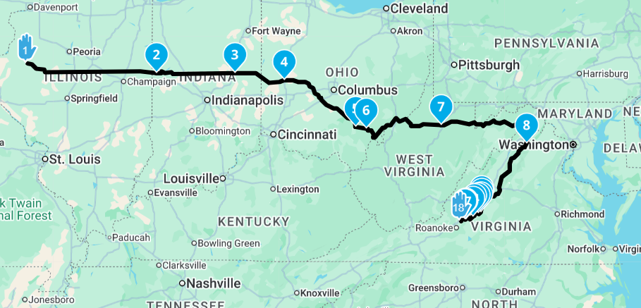
Hello, I'm planning a route on the Blue Ridge parkway and I get to a certain point and when I drop a waypoint as you see in the attached screenshot. I'm on the parkway, and I drop waypoint 18 onto the parkway and the program makes some crazy other route up to the North and down, instead of just staying on the parkway. I'm not sure what going on. Is my route just too long? Also, I was thinking there was a way to split a route? Is there a video out there to show how to do that? This has been frustrating the way it keeps making these crazy offshoots off of my route.
Thanks in advance for any help you can give me. I'm probably doing something wrong somewhere.
Mike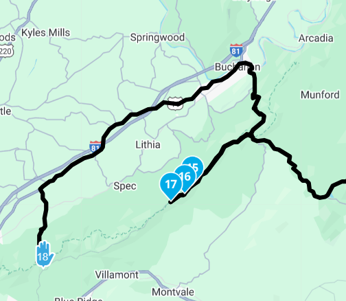
Mike W
2013 Honda Goldwing
Bushtec Trailer
Garmin Zumo XT
Nebraska
youTube channel https://www.youtube.com/@mrjawmaster5854 -
Pleas read the full documentation, it will answer most of your questions.
If not:
Please help us helping with the informations you download here.And answer the
Troubleshooting checklist items
To rule out possible operating errors and better identify the fault or problem, it would be helpful to answer these questions. This will give those assisting you a better overview so they can suggest further steps or a possible solution.MRA Web Planning (planning on a PC, tablet, etc. via a browser)
Which subscription do you have? (Basic, Silver, Gold)
Which routing engine was used? (OSM, TomTom, Here (not overlay))
Which vehicle was planned for? (Car, motorcycle, other)
Which options were set (winding/fastest/shortest), preferably noneMRA Navigation App (everything on a smartphone, tablet, etc. via the app)
Do you have a Navigation Next subscription?
Which hardware and smartphone are you using? (Brand, model)
Which operating system does your smartphone run on? (iOS, Android)
Which software version is installed? (If not current)
Do you use Android Auto and/or Apple CarPlay?
Which display unit is used? (Carpuride/vehicle/other)
Which connection is used? (USB cable or wireless)
What are the navigation settings? (*See post by Hubert Thoring)
Route calculation
Traffic settings
Navigation function
Route validation, opt.
Track navigation
Offline maps
Which avoidance options were used? (Highway, toll road, etc.)
MRA Navigation app route planning
Was a route or track used?
Was the route/track taken from web planning (route directory)?
Was A to B destination planning used?
Which options were used (including curve options)?
Was a round trip planned, including options?
Smartphone settings
How are the permissions for the app set?
Location allowed?
Messages/notifications allowed?
Mobile data allowed?Describe the problem or your question in more detail.
Add screenshots if possible.
The link to the route file may also be helpful.
Translated with DeepL.com (free version)
RT
-
Pleas read the full documentation, it will answer most of your questions.
If not:
Please help us helping with the informations you download here.And answer the
Troubleshooting checklist items
To rule out possible operating errors and better identify the fault or problem, it would be helpful to answer these questions. This will give those assisting you a better overview so they can suggest further steps or a possible solution.MRA Web Planning (planning on a PC, tablet, etc. via a browser)
Which subscription do you have? (Basic, Silver, Gold)
Which routing engine was used? (OSM, TomTom, Here (not overlay))
Which vehicle was planned for? (Car, motorcycle, other)
Which options were set (winding/fastest/shortest), preferably noneMRA Navigation App (everything on a smartphone, tablet, etc. via the app)
Do you have a Navigation Next subscription?
Which hardware and smartphone are you using? (Brand, model)
Which operating system does your smartphone run on? (iOS, Android)
Which software version is installed? (If not current)
Do you use Android Auto and/or Apple CarPlay?
Which display unit is used? (Carpuride/vehicle/other)
Which connection is used? (USB cable or wireless)
What are the navigation settings? (*See post by Hubert Thoring)
Route calculation
Traffic settings
Navigation function
Route validation, opt.
Track navigation
Offline maps
Which avoidance options were used? (Highway, toll road, etc.)
MRA Navigation app route planning
Was a route or track used?
Was the route/track taken from web planning (route directory)?
Was A to B destination planning used?
Which options were used (including curve options)?
Was a round trip planned, including options?
Smartphone settings
How are the permissions for the app set?
Location allowed?
Messages/notifications allowed?
Mobile data allowed?Describe the problem or your question in more detail.
Add screenshots if possible.
The link to the route file may also be helpful.
Translated with DeepL.com (free version)
RT
@Rainer-Treichel I really appreciate your will to help but in all honesty, this checklist is absolutely irrelevant for this post. Even for posts the checklist could make sense, it is just way too long and cannot expect users to completely answer that list
")
I always applaud community efforts, but this is does not achieve the main goal to help people.
-
Hello, I'm planning a route on the Blue Ridge parkway and I get to a certain point and when I drop a waypoint as you see in the attached screenshot. I'm on the parkway, and I drop waypoint 18 onto the parkway and the program makes some crazy other route up to the North and down, instead of just staying on the parkway. I'm not sure what going on. Is my route just too long? Also, I was thinking there was a way to split a route? Is there a video out there to show how to do that? This has been frustrating the way it keeps making these crazy offshoots off of my route.
Thanks in advance for any help you can give me. I'm probably doing something wrong somewhere.
Mike@Mike-wiruth What map are you using for route calculation? HERE / TomTom / OpenStreetMap? I would suggest using HERE and then in the toolkit, turn off the seasonal closures
Posting a link to the route and ensuring it's set to "public" privacy will allow other forum users to help along.
-
Pleas read the full documentation, it will answer most of your questions.
If not:
Please help us helping with the informations you download here.And answer the
Troubleshooting checklist items
To rule out possible operating errors and better identify the fault or problem, it would be helpful to answer these questions. This will give those assisting you a better overview so they can suggest further steps or a possible solution.MRA Web Planning (planning on a PC, tablet, etc. via a browser)
Which subscription do you have? (Basic, Silver, Gold)
Which routing engine was used? (OSM, TomTom, Here (not overlay))
Which vehicle was planned for? (Car, motorcycle, other)
Which options were set (winding/fastest/shortest), preferably noneMRA Navigation App (everything on a smartphone, tablet, etc. via the app)
Do you have a Navigation Next subscription?
Which hardware and smartphone are you using? (Brand, model)
Which operating system does your smartphone run on? (iOS, Android)
Which software version is installed? (If not current)
Do you use Android Auto and/or Apple CarPlay?
Which display unit is used? (Carpuride/vehicle/other)
Which connection is used? (USB cable or wireless)
What are the navigation settings? (*See post by Hubert Thoring)
Route calculation
Traffic settings
Navigation function
Route validation, opt.
Track navigation
Offline maps
Which avoidance options were used? (Highway, toll road, etc.)
MRA Navigation app route planning
Was a route or track used?
Was the route/track taken from web planning (route directory)?
Was A to B destination planning used?
Which options were used (including curve options)?
Was a round trip planned, including options?
Smartphone settings
How are the permissions for the app set?
Location allowed?
Messages/notifications allowed?
Mobile data allowed?Describe the problem or your question in more detail.
Add screenshots if possible.
The link to the route file may also be helpful.
Translated with DeepL.com (free version)
RT
@Rainer-Treichel, yes please don't post this wallpaper under every question...
")
-
Hello, I'm planning a route on the Blue Ridge parkway and I get to a certain point and when I drop a waypoint as you see in the attached screenshot. I'm on the parkway, and I drop waypoint 18 onto the parkway and the program makes some crazy other route up to the North and down, instead of just staying on the parkway. I'm not sure what going on. Is my route just too long? Also, I was thinking there was a way to split a route? Is there a video out there to show how to do that? This has been frustrating the way it keeps making these crazy offshoots off of my route.
Thanks in advance for any help you can give me. I'm probably doing something wrong somewhere.
Mike@Mike-wiruth This usually is caused by seasonal closures, or roads that contradict your settings (like avoid highway or unpaved roads or something.
-
@Mike-wiruth Portions of the Blueridge are still closed due to the weather damage from last year. https://www.nps.gov/blri/planyourvisit/conditions.htm
Shows that section is still closed. Therefore, MRA is routing you around it. Using google maps I get the same type of re-route.
Also note there are other sections in NC that closed as well. -
Ok, now that makes sense. The road being closed the software taking me around it. The only avoidance that I have chosen is --------avoid highways, avoid unpaved roads. Which neither of these would apply to this situation. So, it must be that the road is closed. It would be cool if a pop up would tell you that or some way of telling you that. I'm loving this app. As a matter of fact, my friend that is going with my wife and I on the trip was very impressed as we were planning the route last night and is planning on purchasing a subscription. Below is more info on what subscription and set up I have set on this trip.
Here (MyRoute-app/Garmin) Gold / Nav
I'm a MRA Routeplanner Gold Lifetime member and a Navigation Next Lifetime
Thanks very much for your help.Mike W
2013 Honda Goldwing
Bushtec Trailer
Garmin Zumo XT
Nebraska
youTube channel https://www.youtube.com/@mrjawmaster5854 -
Ok, now that makes sense. The road being closed the software taking me around it. The only avoidance that I have chosen is --------avoid highways, avoid unpaved roads. Which neither of these would apply to this situation. So, it must be that the road is closed. It would be cool if a pop up would tell you that or some way of telling you that. I'm loving this app. As a matter of fact, my friend that is going with my wife and I on the trip was very impressed as we were planning the route last night and is planning on purchasing a subscription. Below is more info on what subscription and set up I have set on this trip.
Here (MyRoute-app/Garmin) Gold / Nav
I'm a MRA Routeplanner Gold Lifetime member and a Navigation Next Lifetime
Thanks very much for your help.@Mike-wiruth said in Need help, seems to be a bug in the app on pc:
It would be cool if a pop up would tell you that or some way of telling you that.
Agreed!
A red 'X' on the 'direct-but-closed' route would educate users about how the routing algorithms sometimes work, and cause less confusion.The closure information obviously exists but it may not be easy to drag it up to the map level, it being hidden in the whole algorithm with a lot of other decision factors also in action.
But if it could, rather than 'What the hell is going on!', it would be 'What the hell, that's smart.'
-
@Mike-wiruth said in Need help, seems to be a bug in the app on pc:
It would be cool if a pop up would tell you that or some way of telling you that.
Agreed!
A red 'X' on the 'direct-but-closed' route would educate users about how the routing algorithms sometimes work, and cause less confusion.The closure information obviously exists but it may not be easy to drag it up to the map level, it being hidden in the whole algorithm with a lot of other decision factors also in action.
But if it could, rather than 'What the hell is going on!', it would be 'What the hell, that's smart.'
@richtea999 if you zoom in on the road it does look like its marked as possibly under construction
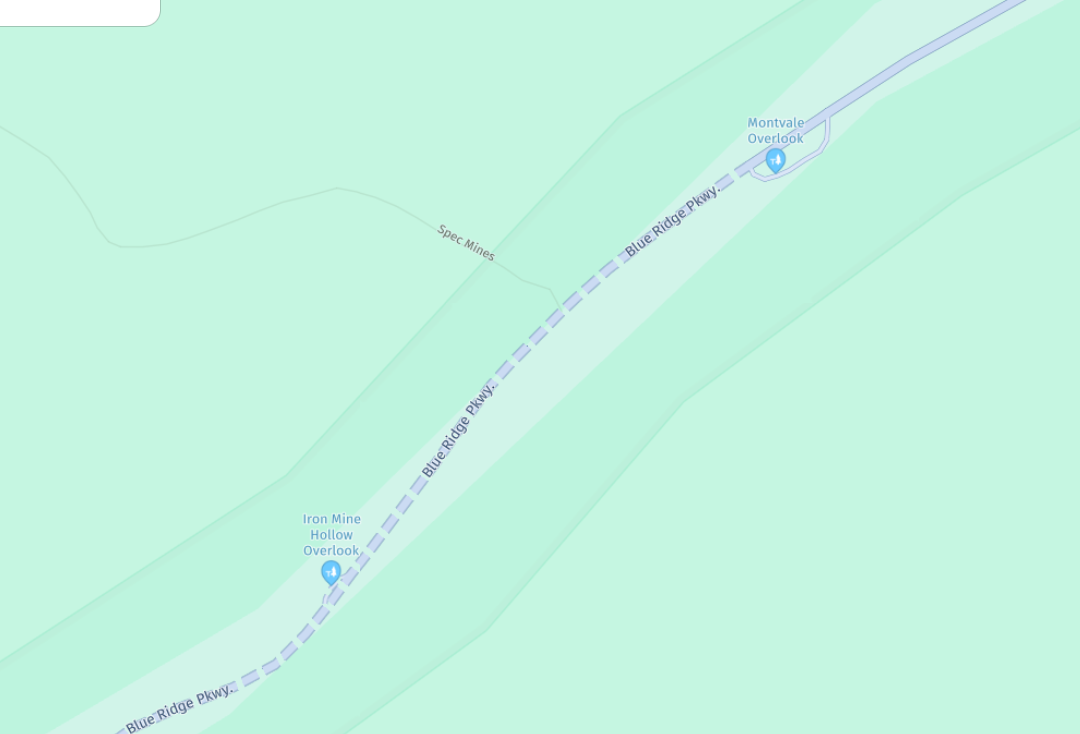
maybe would have been nicer if the Here map had highlighted this in red as it often does for other road works
then again its still showing more than some of the other map overlays
Hello! It looks like you're interested in this conversation, but you don't have an account yet.
Getting fed up of having to scroll through the same posts each visit? When you register for an account, you'll always come back to exactly where you were before, and choose to be notified of new replies (either via email, or push notification). You'll also be able to save bookmarks and upvote posts to show your appreciation to other community members.
With your input, this post could be even better 💗
Register Login-
011120
-
-436942
-
010168
-
1313228
-
0101.3k
-
0346
-
08720
-
03102