Route Makes Unexpected Detour
-
I created a fairly straight forward route that goes south on California US-101. There is a point on the highway where MRA routes an on-and-off for a short period as seen below:
This has been going on since creating the route yesterday. I checked Google Maps and the California department of transportation website, and nothing show closed/impacted in the area. I tried loading shaping points on US-101 on that spot and it only seemed to make things worse, detouring in other strange ways.
Here is the link to the public route. Input would be appreciated:
I tried the following to investigate it:
- TomTom routes correctly along the main road as expected
- OpenStreetMp also routes correctly
- disabling 'Seasonal closures' makes no difference
- reversing the route works correctly
Along with your Google info, that suggests it's faulty data in the HERE mapping database, which you can report to them. (I don't know the link offhand - sorry!)
-
I tried the following to investigate it:
- TomTom routes correctly along the main road as expected
- OpenStreetMp also routes correctly
- disabling 'Seasonal closures' makes no difference
- reversing the route works correctly
Along with your Google info, that suggests it's faulty data in the HERE mapping database, which you can report to them. (I don't know the link offhand - sorry!)
@richtea999 Thanks for doing the checking. I suspected it was faulty HERE Map data, but better to ask in case I did something stupid on my part.
I have to say this isn't the first time something like this happened. The most recent before this was using the Next app to start a route from a parking lot at a non-originating location 13 miles away. Next tried to route me from where I was through a 12-foot high property separation wall to a street on the other side. It would have been the most straight forward route if that wall didn't exist.

Clearly, that instance too was a HERE issue. I'm not going to chase HERE down -- I don't have the time for that. But it does shake my confidence in using Route Planner. I love the product, but trust is a must.
-
@richtea999 Thanks for doing the checking. I suspected it was faulty HERE Map data, but better to ask in case I did something stupid on my part.
I have to say this isn't the first time something like this happened. The most recent before this was using the Next app to start a route from a parking lot at a non-originating location 13 miles away. Next tried to route me from where I was through a 12-foot high property separation wall to a street on the other side. It would have been the most straight forward route if that wall didn't exist.
Clearly, that instance too was a HERE issue. I'm not going to chase HERE down -- I don't have the time for that. But it does shake my confidence in using Route Planner. I love the product, but trust is a must.
@John-S-Parry My workaround when I've had this problem is to add a waypoint and use that to give myself a message to carry straight on. It really is good practice to check your route if you can looking for these things.
-
@John-S-Parry My workaround when I've had this problem is to add a waypoint and use that to give myself a message to carry straight on. It really is good practice to check your route if you can looking for these things.
@Gary-Coates Thanks for the input Gary. 95% of the time I save the route as a GPX 1.1 file and import it into my Zumo XT. The XT it doesn't have direct functionality for waypoint messages. Maybe I could do something with a waypoint name....
I was also thinking that when the XT recalculates the route after import, it might continue on straight. The XT uses HERE maps also, but I haven't always found routes to calculate exactly the same in MRA and the XT. I'll try that when I get a chance.
-
@Gary-Coates Thanks for the input Gary. 95% of the time I save the route as a GPX 1.1 file and import it into my Zumo XT. The XT it doesn't have direct functionality for waypoint messages. Maybe I could do something with a waypoint name....
I was also thinking that when the XT recalculates the route after import, it might continue on straight. The XT uses HERE maps also, but I haven't always found routes to calculate exactly the same in MRA and the XT. I'll try that when I get a chance.
@John-S-Parry Please forgive me if you know all this already but.....
I transfer my routes as GPX 1.1 to my BMW Nav 6 which is basically a garmin zumo. My waypoints are announced.
I had a quick look on the internet and found Zumo XT users discussing their anouncements on their Zumo XT's - https://www.zumouserforums.co.uk/viewtopic.php?t=1570In the MyRoute-app route planner I set the point to be a waypoint (shows as a hand icon) and type the text I want read out as the waypoint name.
Good luck.
-
@John-S-Parry Please forgive me if you know all this already but.....
I transfer my routes as GPX 1.1 to my BMW Nav 6 which is basically a garmin zumo. My waypoints are announced.
I had a quick look on the internet and found Zumo XT users discussing their anouncements on their Zumo XT's - https://www.zumouserforums.co.uk/viewtopic.php?t=1570In the MyRoute-app route planner I set the point to be a waypoint (shows as a hand icon) and type the text I want read out as the waypoint name.
Good luck.
@Gary-Coates Thanks again for input. I try to keep hard (announcing) waypoints limited to real meaningful points. That means either an actual stopping point, or a point I want to measure to for route tracking progress purposes.
I get that I can “trick it” past a point where HERE is screwed up. I guess that’s at least a workaround. I’m more irritated that it should be required at all. All other maps (Google, Apple, TomTom, and OSM) get it right. Over time, I’ve found HERE to be the most inaccurate among the basket of maps. This is just one example among several situations I’ve encountered.
Regardless, I appreciate your recommendations.
-
Can roadworks or accident in one direction be a cause?
Just tried to make a route over the US 101 at that place.
TomTom and Here made the same route. No detour as in your picture.(I use MRA Next only on Android Auto. Every comment, suggestion, etc will be based on my usage with Android Auto)
-
Can roadworks or accident in one direction be a cause?
Just tried to make a route over the US 101 at that place.
TomTom and Here made the same route. No detour as in your picture.@M-Schrijver I’m not sure what you’re looking at. The MRA detour is still there on the 101. I just also just tried the MRA Routeplanner in the app. The same detour appears.
What’s interesting is that the native HERE app doesn’t show the detour. Maybe MRA has some avoidance on that I’m not aware of. I tried to set up zero avoidances, but who knows.
MRA Web desktop is my favorite planner. But in cases like this, I switch to another app that I sometimes use. Again, I don’t want to set up odd waypoints in an attempt to trick the route into being useful.
-
As you can see in my screenshot. The route is made in the direction as you screenshot and is made on the HERE map.
No devation/reroute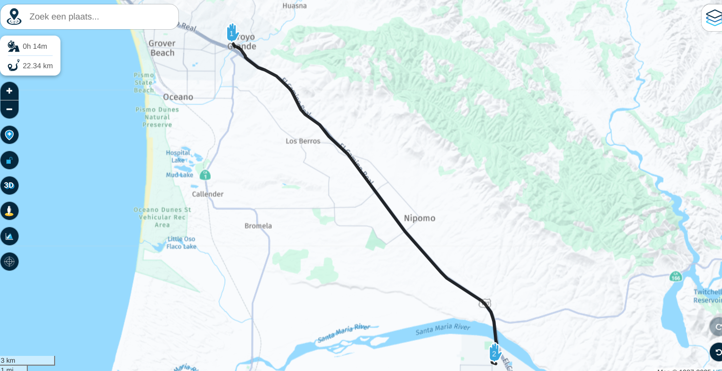
Found the cause.
Change the transport mode from Motor to Car and your problem is solved.You can find a lot of topics were people are told to use Car instead of Motor.
Transport Mode Motor does more damage than it has benefits.(I use MRA Next only on Android Auto. Every comment, suggestion, etc will be based on my usage with Android Auto)
-
As you can see in my screenshot. The route is made in the direction as you screenshot and is made on the HERE map.
No devation/rerouteFound the cause.
Change the transport mode from Motor to Car and your problem is solved.You can find a lot of topics were people are told to use Car instead of Motor.
Transport Mode Motor does more damage than it has benefits.@M-Schrijver Thank you! Yes, I can see where this can cause a lot of confusion. I never would have figured this out. I appreciate your help.
-
As you can see in my screenshot. The route is made in the direction as you screenshot and is made on the HERE map.
No devation/rerouteFound the cause.
Change the transport mode from Motor to Car and your problem is solved.You can find a lot of topics were people are told to use Car instead of Motor.
Transport Mode Motor does more damage than it has benefits.@M-Schrijver @Corjan-Meijerink why don't you change the transport button to car/motor for the time being. That would take care of a lot of problem and explaining.
R1250GS. Started with a Zumo 550, BMW nav IV, Carpe-iter and now Chigee met MRA app.
-
@M-Schrijver @Corjan-Meijerink why don't you change the transport button to car/motor for the time being. That would take care of a lot of problem and explaining.
@Leike-Lodiers When in "Car" mode, routes do show a picture of a car and a motorcycle on top of each other for mode. BTW, is there a way to change the mode for routes already created? I can't figure out how to change it for other older routes.
In any case, when in motorcycle mode, the route calculated in my example is just plain wrong at any level. Different for an explainable reason is OK, but that's not the situation here. What happened in my case is clearly a bug.
@Corjan-Meijerink, is this on a list of upcoming fixes?
-
@Leike-Lodiers When in "Car" mode, routes do show a picture of a car and a motorcycle on top of each other for mode. BTW, is there a way to change the mode for routes already created? I can't figure out how to change it for other older routes.
In any case, when in motorcycle mode, the route calculated in my example is just plain wrong at any level. Different for an explainable reason is OK, but that's not the situation here. What happened in my case is clearly a bug.
@Corjan-Meijerink, is this on a list of upcoming fixes?
@John-S-Parry what exactly would be?
-
@John-S-Parry what exactly would be?
@Corjan-Meijerink The fix?? I guess to calculate the route correctly. Which in this case is a direct line between two points.
I'm not sure I understand the why there is confusion. The route I showed was a trip south on a major interstate (US-101) in California. There isn't a scenario I see where it makes logical sense to detour off the interstate to a side road, and then get back on. It doesn't make sense regardless of transportation mode.
If in fact there is a reasonable explanation, please share. Otherwise, I don't know how else I'd frame it other than being a route calculation bug.
-
@Leike-Lodiers When in "Car" mode, routes do show a picture of a car and a motorcycle on top of each other for mode. BTW, is there a way to change the mode for routes already created? I can't figure out how to change it for other older routes.
In any case, when in motorcycle mode, the route calculated in my example is just plain wrong at any level. Different for an explainable reason is OK, but that's not the situation here. What happened in my case is clearly a bug.
@Corjan-Meijerink, is this on a list of upcoming fixes?
@John-S-Parry said in Route Makes Unexpected Detour:
@Leike-Lodiers When in "Car" mode, routes do show a picture of a car and a motorcycle on top of each other for mode. BTW, is there a way to change the mode for routes already created? I can't figure out how to change it for other older routes.
In any case, when in motorcycle mode, the route calculated in my example is just plain wrong at any level. Different for an explainable reason is OK, but that's not the situation here. What happened in my case is clearly a bug.
@Corjan-Meijerink, is this on a list of upcoming fixes?
Open the route in MRA on your PC and from the left bar menu select 'Route Information' and change it under 'Transport Mode'
GSA1250
HD Street Glide
HD Sport Glide
XT500 x 2 -
@Corjan-Meijerink The fix?? I guess to calculate the route correctly. Which in this case is a direct line between two points.
I'm not sure I understand the why there is confusion. The route I showed was a trip south on a major interstate (US-101) in California. There isn't a scenario I see where it makes logical sense to detour off the interstate to a side road, and then get back on. It doesn't make sense regardless of transportation mode.
If in fact there is a reasonable explanation, please share. Otherwise, I don't know how else I'd frame it other than being a route calculation bug.
@John-S-Parry Exactly! Please report it here: https://mapfeedback.here.com/#/report
We are not responsible for the HERE route calculation itself.
I'll report it too! Makes stuff gets notices quicker
I know that for customers it doesn't matter who fixes it, as long it works in MRA but nothing much I can do about this specific case
-
@John-S-Parry Exactly! Please report it here: https://mapfeedback.here.com/#/report
We are not responsible for the HERE route calculation itself.
I'll report it too! Makes stuff gets notices quicker
I know that for customers it doesn't matter who fixes it, as long it works in MRA but nothing much I can do about this specific case@Corjan-Meijerink Thanks for your response. I'll report when time permits.
What's interesting is the native HERE app (HERE WeGo), using the motorcycle profile setting, calculates correctly. I'll also try importing into the XT (also HERE) to see what's actually calculated. I don't know why MRA's HERE implementation would be different, but I guess there are complexities in play I don't understand. At least there is a solution I can implement now.
-
@John-S-Parry said in Route Makes Unexpected Detour:
@Leike-Lodiers When in "Car" mode, routes do show a picture of a car and a motorcycle on top of each other for mode. BTW, is there a way to change the mode for routes already created? I can't figure out how to change it for other older routes.
In any case, when in motorcycle mode, the route calculated in my example is just plain wrong at any level. Different for an explainable reason is OK, but that's not the situation here. What happened in my case is clearly a bug.
@Corjan-Meijerink, is this on a list of upcoming fixes?
Open the route in MRA on your PC and from the left bar menu select 'Route Information' and change it under 'Transport Mode'
@Rob-Kelley Thanks for pointing me to the right place.

-
@Corjan-Meijerink Thanks for your response. I'll report when time permits.
What's interesting is the native HERE app (HERE WeGo), using the motorcycle profile setting, calculates correctly. I'll also try importing into the XT (also HERE) to see what's actually calculated. I don't know why MRA's HERE implementation would be different, but I guess there are complexities in play I don't understand. At least there is a solution I can implement now.
Correction to my previous comment that motorcycle mode routes correctly on the HERE WeGo app. It doesn’t.

Car mode routes correctly, while motorcycle has the same issue found in MRA. It’s definitely a HERE bug.
Hello! It looks like you're interested in this conversation, but you don't have an account yet.
Getting fed up of having to scroll through the same posts each visit? When you register for an account, you'll always come back to exactly where you were before, and choose to be notified of new replies (either via email, or push notification). You'll also be able to save bookmarks and upvote posts to show your appreciation to other community members.
With your input, this post could be even better 💗
Register Login-
-2967
-
0530
-
0443
-
718867
-
0344
-
09156
-
1351.9k
-
0213