Heading to an Asylum
-
BMW R1250RS. Nav 6. I love my detailed planning via MyRoute App but when I hit the road it all goes tits up. Despite using HERE and using many Shaping Points the bloody Nav 6 makes its own mind up and completely ignores my planning which has taken many hours, and directs me anyway but what I've planned.
Can some kind soul help me as I'm going nuts and want my European Trips that I'm starting to plan now to go as I want ?
Would a Tom Tom be any better ? -
Can you share a route and explain what is going wrong at what point?
I don't say in general TomTom is beter then Nav 6 because I don't know that device in particular. (how old is the Nav 6? and is it up-to-date with its software and maps?)
I think you need first to figure out what is going wrong before buying e new device. And if you are going to buy a new one, i would recommend looking in MRA next (navigation app). -
BMW R1250RS. Nav 6. I love my detailed planning via MyRoute App but when I hit the road it all goes tits up. Despite using HERE and using many Shaping Points the bloody Nav 6 makes its own mind up and completely ignores my planning which has taken many hours, and directs me anyway but what I've planned.
Can some kind soul help me as I'm going nuts and want my European Trips that I'm starting to plan now to go as I want ?
Would a Tom Tom be any better ?I am happy to help, so the following.
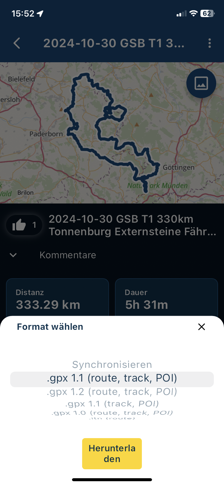
The export of the created route is recommended in the format 1.1 GPX
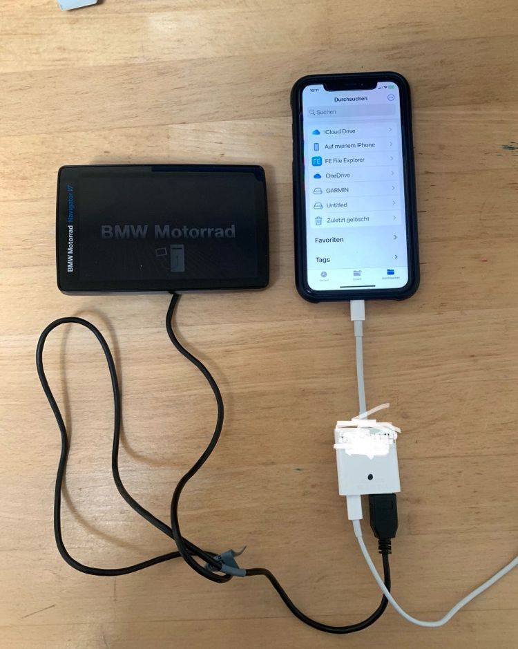
Then transfer to the Navi N6:
Either:
-
from PC via cable to N6
-
from the mobile phone via adapter and cable to the N6
s. Pictures
ich helfe gerne, also folgendes.
Der Export der erstellten Route empfiehlt sich im Format 1.1 GPX
Dann an das Navi N6 übertragen:
entweder:- vom PC über Kabel an N6
- vom Handy über Adapter und Kabel an das N6
s. Bilder
-
-
BMW R1250RS. Nav 6. I love my detailed planning via MyRoute App but when I hit the road it all goes tits up. Despite using HERE and using many Shaping Points the bloody Nav 6 makes its own mind up and completely ignores my planning which has taken many hours, and directs me anyway but what I've planned.
Can some kind soul help me as I'm going nuts and want my European Trips that I'm starting to plan now to go as I want ?
Would a Tom Tom be any better ?Export from mobile phone to ... the N6 see pictures
Export vom Handy an … das N6 s. Bilder
-
BMW R1250RS. Nav 6. I love my detailed planning via MyRoute App but when I hit the road it all goes tits up. Despite using HERE and using many Shaping Points the bloody Nav 6 makes its own mind up and completely ignores my planning which has taken many hours, and directs me anyway but what I've planned.
Can some kind soul help me as I'm going nuts and want my European Trips that I'm starting to plan now to go as I want ?
Would a Tom Tom be any better ?MRA Route:
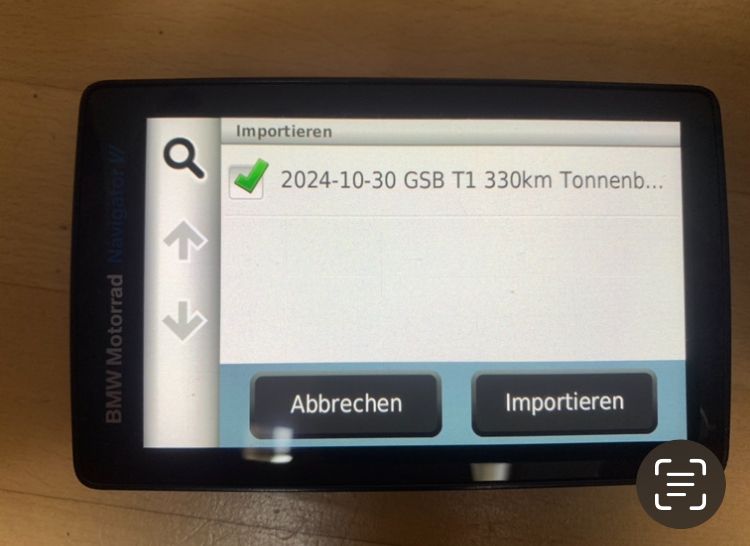
Save the exported file on the N6 navigation system under /GPX. It works just as well on a mobile phone as it does on a PC...if you copy it directly via an explorer.
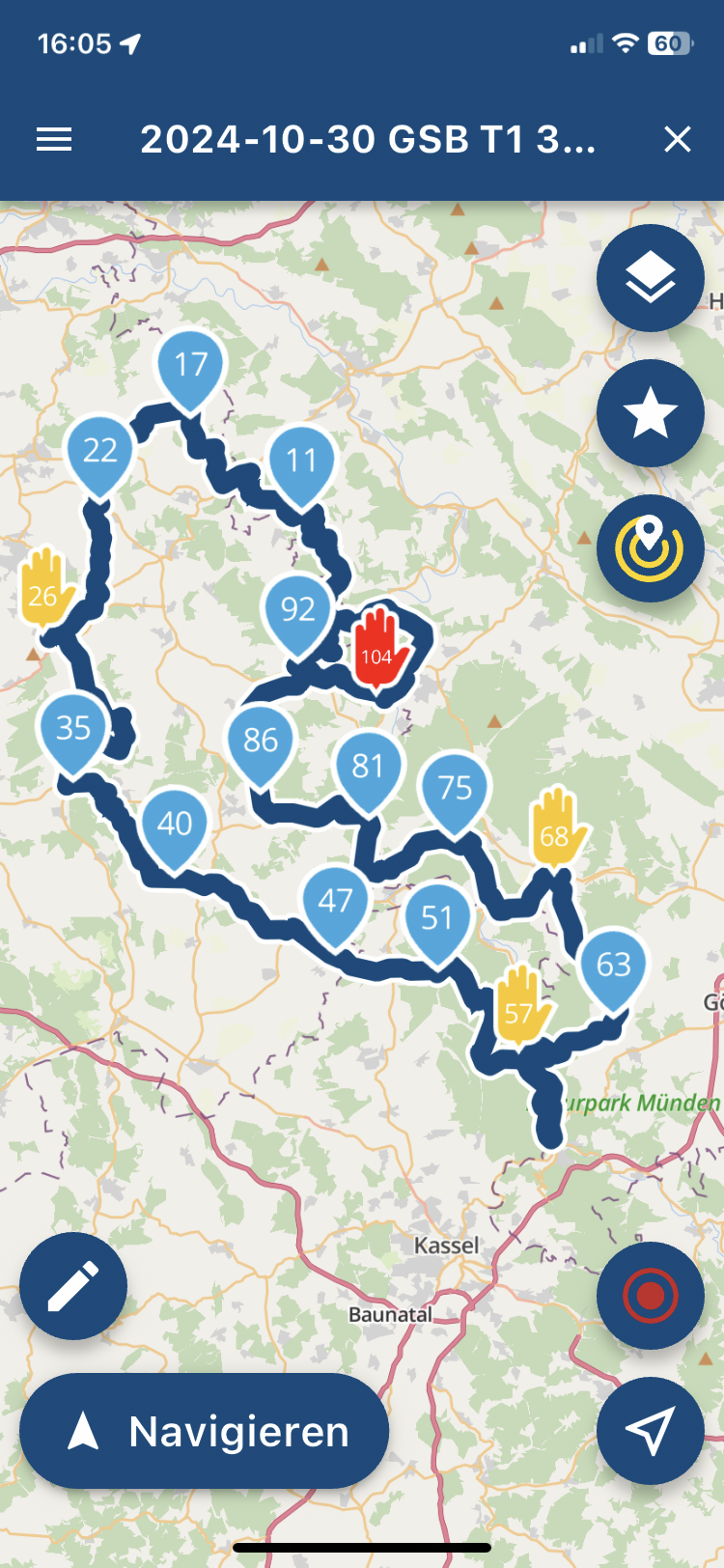
After loading the route, it will look like this on the navigation system. Now check the settings on the N6 navigation system.
Navi N6: under Settings
Navigation / recalculation mode on OFF otherwise the route will be destroyed!!!!
-
Navigation / Route preference / Shorter time
-
then Shorter time = quick connection between WP 1 to WP 2 etc.
-
Navigation / Avoidances /
-
then U-turns!
-
then unpaved roads
Auf dem Navi N6 unter /GPX die Datei aus dem Export im 1.1 GPX Format speichern. Es geht vom Handy genau so wie vom PC wenn man es direkt über einen Explorer kopiert.
Auf dem Navi sieht es dann nach laden der Route so aus. Jetzt die Einstellungen auf dem Navi N6 kontrollieren.
Navi N6: unter Einstellungen
Wichtig: Navigation / Neuberechnungsmodus auf AUS sonst wird die Route zerschossen !!!!!
-
Navigation / Routenpräferenz / Kürzere Zeit
-
dann Kürzere Zeit = schnelle Verbindung zwischen WP 1 zu WP 2 usw.
-
Navigation / Vermeidungen /
-
dann Kehrtwenden !
-
dann unbefestigte Straßen
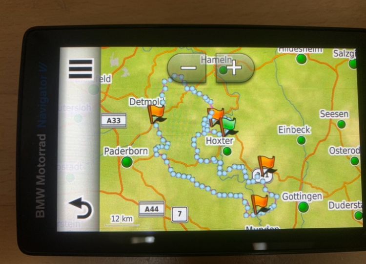
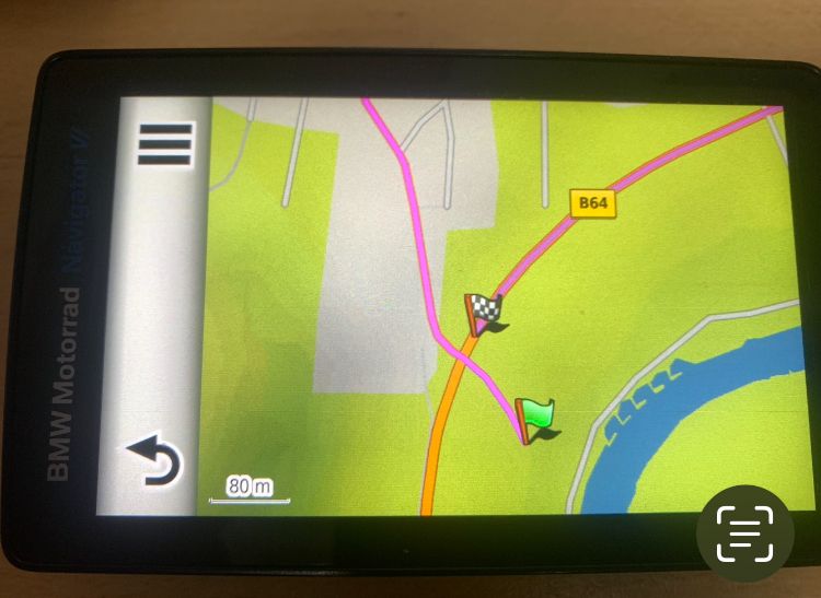
The flags are Via points from the planning green = start orange via on the way, finish via is self-explanatory !!
Die Fähnchen sind Via Punkte aus der Planung Grün = Start Orange Via unterwegs , Ziel Via erklärt sich von selbst !!
VG Hubert
Beta Test "Next App" dazu die Hardware .
iPad 9. Gen iOS 26.5 / iPhone 16e iOS 26.5/ Navi iPhone Xr iOS 18.7.9 / PC mit MS Win11 /❗️MyRoute-App im Cradel und Remotek-One❗️ Info zu MRA & Remotek One -
-
MRA Route:
Save the exported file on the N6 navigation system under /GPX. It works just as well on a mobile phone as it does on a PC...if you copy it directly via an explorer.
After loading the route, it will look like this on the navigation system. Now check the settings on the N6 navigation system.
Navi N6: under Settings
Navigation / recalculation mode on OFF otherwise the route will be destroyed!!!!
-
Navigation / Route preference / Shorter time
-
then Shorter time = quick connection between WP 1 to WP 2 etc.
-
Navigation / Avoidances /
-
then U-turns!
-
then unpaved roads
Auf dem Navi N6 unter /GPX die Datei aus dem Export im 1.1 GPX Format speichern. Es geht vom Handy genau so wie vom PC wenn man es direkt über einen Explorer kopiert.
Auf dem Navi sieht es dann nach laden der Route so aus. Jetzt die Einstellungen auf dem Navi N6 kontrollieren.
Navi N6: unter Einstellungen
Wichtig: Navigation / Neuberechnungsmodus auf AUS sonst wird die Route zerschossen !!!!!
-
Navigation / Routenpräferenz / Kürzere Zeit
-
dann Kürzere Zeit = schnelle Verbindung zwischen WP 1 zu WP 2 usw.
-
Navigation / Vermeidungen /
-
dann Kehrtwenden !
-
dann unbefestigte Straßen
The flags are Via points from the planning green = start orange via on the way, finish via is self-explanatory !!
Die Fähnchen sind Via Punkte aus der Planung Grün = Start Orange Via unterwegs , Ziel Via erklärt sich von selbst !!
Video von MRA Link to Video
-
-
BMW R1250RS. Nav 6. I love my detailed planning via MyRoute App but when I hit the road it all goes tits up. Despite using HERE and using many Shaping Points the bloody Nav 6 makes its own mind up and completely ignores my planning which has taken many hours, and directs me anyway but what I've planned.
Can some kind soul help me as I'm going nuts and want my European Trips that I'm starting to plan now to go as I want ?
Would a Tom Tom be any better ?@John-B-1 The best answer you can get follows after you shared the route here. Make sure it's set to public
Hello! It looks like you're interested in this conversation, but you don't have an account yet.
Getting fed up of having to scroll through the same posts each visit? When you register for an account, you'll always come back to exactly where you were before, and choose to be notified of new replies (either via email, or push notification). You'll also be able to save bookmarks and upvote posts to show your appreciation to other community members.
With your input, this post could be even better 💗
Register Login-
-320368
-
0547
-
0596
-
0355
-
09141
-
0320
-
1224
-
0233