Proposal for an algorithm to guide around unexpected road closures
-
In a thread "https://forum.myrouteapp.com/topic/10748/how-to-exclude-short-time-road-blocks-during-navigation/1", there was an intense discussion about the pros and cons of guided detours around unexpected road closures. Some motorcyclists prefer a solution similar to TomTom.
I would like to propose an algorithm that, in my opinion, would enable guided detours around road closures.
The scenario: A motorcyclist is navigating with MRA on a pre-planned route. He encounters a temporary road closure that is not marked on the planning map and is therefore not bypassed.
The task is to create a feature in MRA that guides the rider around the closure, similar to TomTom.
Definitions:
Shaping Point A: the point where the motorcyclist is actually located before the roadblock.
Shaping Point B: the point on the known planned route beyond which a roadblock is suspected.The algorithm could work as follows.
1: The rider stops and selects “Detour around a roadblock” from the navigation menu. There, he enters the length of the expected roadblock (e.g., 10 km).
.
.
2: MRA now automatically adds the two additional shaping points, A and B, to the route. The waypoints along the remainder of the route after Point A to the destination are incremented by 2, since the route now has two more shaping points.
.
.
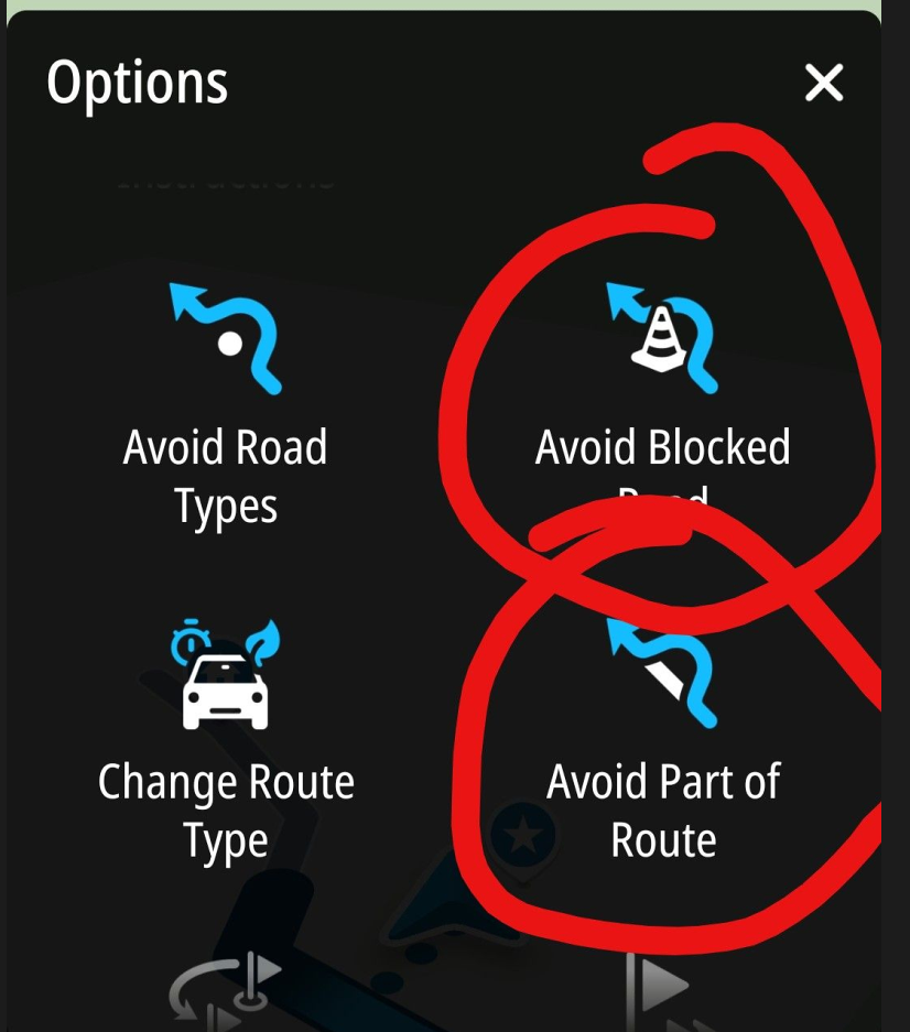
3: MRA excludes the section between shaping points A and B from the permitted roads—similar to how it handles highways or toll roads to be avoided, etc. To do this, a programming solution must be found that does not rely on the planning map, since this exclusion is not present there.
.
.
4a If a planned shaping point is located on the now-blocked route, it is skipped.
4b: If a planned viapoint is located on the now-blocked route, a warning is issued so that the rider can decide whether to be redirected to that point from B or to skip it.
.
.
5: MRA now calculates a new route segment that leads at least to point B. If the original route is not reached again until further along toward the final destination due to road conditions, shaping point B is skipped during navigation.Of course, I don’t know how this can be implemented programmatically, but that’s what @corjan-meijerink, our mastermind, is here for.
BMW R 1200 RT
Tourenorientiert
MRA lifetime member -
All this would be possible without all the hassle of adding extra waypoints
")
That said it’s not a currently planned feature but it is in my mind after reading the interesting discussions. Quite often those suddenly magically get done (or at least a proof of concept) over a boring weekend
 Not making any promises!
 -
All this would be possible without all the hassle of adding extra waypoints
That said it’s not a currently planned feature but it is in my mind after reading the interesting discussions. Quite often those suddenly magically get done (or at least a proof of concept) over a boring weekend
Not making any promises!OK, thanks for your response.
I just wanted to document an idea I got during a walk with my dog.
Best, Axel
BMW R 1200 RT
Tourenorientiert
MRA lifetime member -
OK, thanks for your response.
I just wanted to document an idea I got during a walk with my dog.
Best, Axel
@Axel-Härtl that is definitely appreciated!
-
In a thread "https://forum.myrouteapp.com/topic/10748/how-to-exclude-short-time-road-blocks-during-navigation/1", there was an intense discussion about the pros and cons of guided detours around unexpected road closures. Some motorcyclists prefer a solution similar to TomTom.
I would like to propose an algorithm that, in my opinion, would enable guided detours around road closures.
The scenario: A motorcyclist is navigating with MRA on a pre-planned route. He encounters a temporary road closure that is not marked on the planning map and is therefore not bypassed.
The task is to create a feature in MRA that guides the rider around the closure, similar to TomTom.
Definitions:
Shaping Point A: the point where the motorcyclist is actually located before the roadblock.
Shaping Point B: the point on the known planned route beyond which a roadblock is suspected.The algorithm could work as follows.
1: The rider stops and selects “Detour around a roadblock” from the navigation menu. There, he enters the length of the expected roadblock (e.g., 10 km).
.
.
2: MRA now automatically adds the two additional shaping points, A and B, to the route. The waypoints along the remainder of the route after Point A to the destination are incremented by 2, since the route now has two more shaping points.
.
.
3: MRA excludes the section between shaping points A and B from the permitted roads—similar to how it handles highways or toll roads to be avoided, etc. To do this, a programming solution must be found that does not rely on the planning map, since this exclusion is not present there.
.
.
4a If a planned shaping point is located on the now-blocked route, it is skipped.
4b: If a planned viapoint is located on the now-blocked route, a warning is issued so that the rider can decide whether to be redirected to that point from B or to skip it.
.
.
5: MRA now calculates a new route segment that leads at least to point B. If the original route is not reached again until further along toward the final destination due to road conditions, shaping point B is skipped during navigation.Of course, I don’t know how this can be implemented programmatically, but that’s what @corjan-meijerink, our mastermind, is here for.
@Axel-Härtl I read the discussion carefully and I completely agree with your proposal. Anything that improves MRa is welcome!
-
All this would be possible without all the hassle of adding extra waypoints
That said it’s not a currently planned feature but it is in my mind after reading the interesting discussions. Quite often those suddenly magically get done (or at least a proof of concept) over a boring weekend
Not making any promises!@Corjan-Meijerink Super!!!!
-
As this is a subject close to my heart, I’d like to highlight once again a scenario that has become all too common, where the ability to block an exit on the planned route would be extremely helpful.
You reach a motorway exit that has only just been closed. So you can only continue straight ahead. After a few kilometres, you are diverted at the next opportunity. At that moment, you don’t know whether the app is (incorrectly) rerouting you back or whether it has found a new way back onto the planned route beyond the closure.
That is why it would be so important to be able to mark the closure with a button so that it is excluded from the routing. (Please bear in mind that you are driving on the motorway and cannot stop to fiddle about on the small screen).
This scenario, as well as sudden closures on country roads due to fallen trees, landslides, etc., is unfortunately becoming increasingly common and is no longer the absolute exception.
There are people with a very good sense of direction who don’t need this – for me, it would be a huge help. -
As this is a subject close to my heart, I’d like to highlight once again a scenario that has become all too common, where the ability to block an exit on the planned route would be extremely helpful.
You reach a motorway exit that has only just been closed. So you can only continue straight ahead. After a few kilometres, you are diverted at the next opportunity. At that moment, you don’t know whether the app is (incorrectly) rerouting you back or whether it has found a new way back onto the planned route beyond the closure.
That is why it would be so important to be able to mark the closure with a button so that it is excluded from the routing. (Please bear in mind that you are driving on the motorway and cannot stop to fiddle about on the small screen).
This scenario, as well as sudden closures on country roads due to fallen trees, landslides, etc., is unfortunately becoming increasingly common and is no longer the absolute exception.
There are people with a very good sense of direction who don’t need this – for me, it would be a huge help.Perfect. I totally agree.
In my proposal the usage of shaping point A and B would be as follows.
If you press the button "here is beginning of a closure" shaping point A is automatically set.
If you leave the highway and press "here is end of a closure" shaping point B is automatically set.
The algorithm then excludes the road between A and B from the calculation and continues as I described.
Best, Axel
BMW R 1200 RT
Tourenorientiert
MRA lifetime member -
Perfect. I totally agree.
In my proposal the usage of shaping point A and B would be as follows.
If you press the button "here is beginning of a closure" shaping point A is automatically set.
If you leave the highway and press "here is end of a closure" shaping point B is automatically set.
The algorithm then excludes the road between A and B from the calculation and continues as I described.
Best, Axel
@Axel-Härtl Would this prevent the app from trying to reroute via the closed exit?
If I understand your suggestion correctly, only the section from the closed exit (first press of the button) straight ahead until the second press of the button would be blocked.
However, the exit itself (and certainly a few kilometres beyond it) – the road or motorway you actually wanted to take – would need to be blocked. -
Now we are discussing 2 different scenarios? If I understand correctly, we have:
- the road you are driving (following the planned route) is suddenly blocked. So, you need to leave this road - and you need guidance to get back on the planned route
- You are supposed to leave the road you’re driving on – following the planned route. But the exit is suddenly blocked. So you can’t leave this road – and you need guidance to get back on the planned route
-
Yes, there are two scenarios under discussion now.
1: if a planned route is blocked -> the algorithm is decribed in my post #1
.
.
2: by selecting "here is the end of the closure" at the exit of a motorway, shaping point B would not be set on the originally planned route but somewhere else (i.e. at the exit).So in this case the algorithm should navigate to the nearest point of the originally planned route.
Here the rule for skipping a via point between A and the location, where the original route is met again must be implemented as I proposed in post #1
-
@Axel-Härtl
Don't you have those diversion signs in Germany, like we have in the Netherlands, that direct you around the location of the roadworks when there are roadworks somewhere?Or do you mean, for example, roadworks that suddenly appear without clear prior notice?
I get the point about having a button or function in MRA that allows you to bypass roadworks. Last year in Belgium, I experienced 3 or 4 times that roadworks suddenly appeared that hadn't been there a week before my tour. It is annoying, but stopping for a moment and checking how to get from A to B is, in my opinion, perfectly doable.
| MRA Gold Member |
| Garmin Zumo XT + BMW K1200GT |
| MRA Next + Kawasaki Z650 | -
@Axel-Härtl
Don't you have those diversion signs in Germany, like we have in the Netherlands, that direct you around the location of the roadworks when there are roadworks somewhere?Or do you mean, for example, roadworks that suddenly appear without clear prior notice?
I get the point about having a button or function in MRA that allows you to bypass roadworks. Last year in Belgium, I experienced 3 or 4 times that roadworks suddenly appeared that hadn't been there a week before my tour. It is annoying, but stopping for a moment and checking how to get from A to B is, in my opinion, perfectly doable.
@Nomko-Nomden Yes, of course there are diversion signs when it’s a PLANNED construction project at a motorway exit. You can, after all, take these into account during the planning stage.
However, I’m talking about the increasingly frequent SUDDEN closures of motorway exits.
Or fallen trees or landslides on country roads.
In such cases, I would like to see a button that prevents the navigationdevice from repeatedly attempting to navigate through the closure.
I would like to point out that you simply cannot stop to look at anything or make a change because you are not allowed to stop on motorways.It would be possible on country roads, but it would be fiddly to set up a diversion manually on the small screen. -
@Axel-Härtl
Don't you have those diversion signs in Germany, like we have in the Netherlands, that direct you around the location of the roadworks when there are roadworks somewhere?Or do you mean, for example, roadworks that suddenly appear without clear prior notice?
I get the point about having a button or function in MRA that allows you to bypass roadworks. Last year in Belgium, I experienced 3 or 4 times that roadworks suddenly appeared that hadn't been there a week before my tour. It is annoying, but stopping for a moment and checking how to get from A to B is, in my opinion, perfectly doable.
@Nomko-Nomden
Hello Nomko
This entire discussion pertains to the scenario where there is an unplanned, last-minute road closure. In such cases, there are often (based on experience) no detour signs. (Unfortunately, Germany is also on the decline right now, which is making the situation increasingly worse—but that’s a different discussion.)
In this case, you have to stop and re-plan your route. This is certainly possible with a little effort. However, adding a shaping point by pressing and holding a road segment on my phone during navigation unfortunately doesn’t work. So I have to stop the navigation, go back to planning mode, and replan.
However, if you encounter a closed exit on a highway, this isn’t an option, since you’re not allowed to stop on highways. By the time you reach the next possible exit, you’re no longer on the planned route and may be redirected back.
Various approaches to this issue (unfortunately scattered throughout the thread) have been compiled here.
In addition to the arguments for including a simple detour feature in MRA, we also see that other navigation systems offer this capability.
@Corjan-Meijerink has taken up the basic idea but has also written that implementation is not currently planned.
I hope this clarifies our request somewhat.
-
I do hope that we’re not going to over complicate the app by adding more buttons and settings. In my 50 years of using our road systems, I have encountered both blocked motorway exits caused by accidents and unexpected road closures (fallen tree) and I have always dealt with them without an additional magic button. Some of the posts in this thread paint an almost apocalyptic picture where these unexpected closures are happening on a daily basis. Just my thoughts.
Always willing to help if I can.
Triumph Tiger 1200 XRT called Tina.
MRA Navigation Next and SilverFox BJ8 -
I do hope that we’re not going to over complicate the app by adding more buttons and settings. In my 50 years of using our road systems, I have encountered both blocked motorway exits caused by accidents and unexpected road closures (fallen tree) and I have always dealt with them without an additional magic button. Some of the posts in this thread paint an almost apocalyptic picture where these unexpected closures are happening on a daily basis. Just my thoughts.
Hi Nick. Do you regard TomTom as being overcomplicated, since there is such a button?
By the way: I encounter an unexpected closure nearly on every tour. This might be because I prefer small, windy roads.
On those roads you hardly find detour signs. They are simply closed and that‘s it. -
Offcouse i have my opnion about this issue.
Many times there signs which to follow to get around the roadworks but the question i always have. Does this re-route get me back on the route or sends it me far off-route? So i rarely use these signs. I always look on the map where to go.I have many years of experience of riding with TomTom and routes (track based).
If routeworks were not present or aware on the map during planning, but they are on the map when the route was started on the navigation. TomTom reroutes me automatic around these roadworks. No questions or remarks. 9 of 10 times it works like a charm. Especially in cities/villages. But there are limits (that's the 1 time it doesn't work).Instead of a special roadworks button/option. Isn't is possible to long press on a waypoint or point on the route and then select the option roadworks. Then the navigation knows what to do.
A few years ago i was in Scotland and suddenly the road was closed due to an accident. We were pretty quick after the accident happened because we did see some policecars going to the accident with sirens on. I didn't took long this closure was mentioned to TomTom and TomTom found me a re-route by itself without input from me. Suddenly it told me to turn around and get an exit a mile back. It brought me as close as possible after the roadclosure back on the original route.
All and all.
I suspect a function like the roadworks button will be more and more unneseccary in the future. More and more roadworks and closures are going to be registered which are available for navigation software. Then it is up-to the software how deal with this. -
To all valued participants in this discussion.
I think everything essential has been said.
I posted this suggestion specifically in the “Suggestions and Discussion” section because I wanted to propose what I believe is an improvement to MRA.
The topic has been assigned to @Corjan-Meijerink, and he has already responded to it.
I don’t know how the decision-making processes work at MRA, but for me, the discussion here has reached a point where I don’t want to invest any more effort into it.
Should it come to implementation, I would be more than happy to offer my assistance in designing the process. Process development is my profession.
Best, Axel
BMW R 1200 RT
Tourenorientiert
MRA lifetime member -
To all valued participants in this discussion.
I think everything essential has been said.
I posted this suggestion specifically in the “Suggestions and Discussion” section because I wanted to propose what I believe is an improvement to MRA.
The topic has been assigned to @Corjan-Meijerink, and he has already responded to it.
I don’t know how the decision-making processes work at MRA, but for me, the discussion here has reached a point where I don’t want to invest any more effort into it.
Should it come to implementation, I would be more than happy to offer my assistance in designing the process. Process development is my profession.
Best, Axel
@Axel-Härtl I think it's a fantastic idea. I don't understand the "fear" some users have of improvements. If there were no improvements, we'd still be using paper maps.
Again, thank you very much, Axel, for your suggestion.Creator and administrator of the largest MRA groups.
- https://t.me/MRa_by_b0hd1
- https://www.myrouteapp.com/group/messages/7007
- YouTube: @demco17
- Ex-routexpert, current beta tester and MRA expert. Creator of tutorials, manuals, and MRA user trainer.
-
@Axel-Härtl I think it's a fantastic idea. I don't understand the "fear" some users have of improvements. If there were no improvements, we'd still be using paper maps.
Again, thank you very much, Axel, for your suggestion.

Hello! It looks like you're interested in this conversation, but you don't have an account yet.
Getting fed up of having to scroll through the same posts each visit? When you register for an account, you'll always come back to exactly where you were before, and choose to be notified of new replies (either via email, or push notification). You'll also be able to save bookmarks and upvote posts to show your appreciation to other community members.
With your input, this post could be even better 💗
Register Login-
7512.9k
-
05112
-
011384
-
0278
-
0255
-
0241
-
734447
-
0897