function EXPAND
-
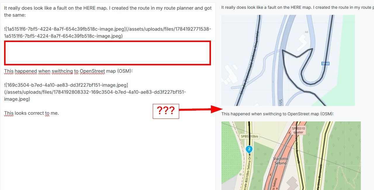
@erdna, you may be right. But this is not the point. Why is MRA making a totally different route when waypoints are added (with openstreet map)?
WP should be added to the route that was created with OPM as well as it is done with TT map.Hardware
iPhone 12 pro (iOS 26.2.1)
iPad (7.Gen.) 18.7.3
Oukitel RT3 Pro (Andr. 14)
Wireless CarPlay mit (Elebest C650)
Wired CarPlay (SEAT Arona - 2021)
MRA Workshops in Deutsch sind hier zu finden -
@erdna, you may be right. But this is not the point. Why is MRA making a totally different route when waypoints are added (with openstreet map)?
WP should be added to the route that was created with OPM as well as it is done with TT map.@Jörgen said in function EXPAND:
Why is MRA making a totally different route when waypoints are added (with openstreet map)?
Seemingly that is due to a randomize function in the automatic creation of scenic routes. A curvy route between 2 points can be different from a curvy route between three points, even when the middle point is on the original 2-point route. That does not sound completely illogical to me.
WP should be added to the route that was created with OPM as well as it is done with TT map.
Remember that routes are calculated by the map-providers, not by MRA. Each map provider does things differently. That is nothing new.
I am just an enthusiastic MRA user, and hope you will be one too!
Most motorcycle problems are caused by the nut that connects the handlebar to the saddle.
Check out RideSleepRepeat.eu, a biker community for sharing stays across Europe
-
OK,
I'll leave MRA and a software problem aside for now.
Adding loads of shaping points seems impractical to me.
There is <Compare route calculation with>.
Then you set shaping points to make the routes congruent. Incidentally, that was one of the parts involved in the creation of MRA")
Or you can display the route as an overlay (on the left side of the menu). This would also work with a track log. Or simply the desired route. And on this basis, you then create a new route with the route engine of your choice.
I find the first alternative nicer and faster.
Interesting topic, maybe I'll add it to my to-do list for the next video conference.
RTTranslated with DeepL.com (free version)
-
@Jörgen said in function EXPAND:
Why is MRA making a totally different route when waypoints are added (with openstreet map)?
Seemingly that is due to a randomize function in the automatic creation of scenic routes. A curvy route between 2 points can be different from a curvy route between three points, even when the middle point is on the original 2-point route. That does not sound completely illogical to me.
WP should be added to the route that was created with OPM as well as it is done with TT map.
Remember that routes are calculated by the map-providers, not by MRA. Each map provider does things differently. That is nothing new.
@Con-Hennekens said in function EXPAND:
@Jörgen said in function EXPAND:
Why is MRA making a totally different route when waypoints are added (with openstreet map)?
Seemingly that is due to a randomize function in the automatic creation of scenic routes. A curvy route between 2 points can be different from a curvy route between three points, even when the middle point is on the original 2-point route. That does not sound completely illogical to me.
WP should be added to the route that was created with OPM as well as it is done with TT map.
Remember that routes are calculated by the map-providers, not by MRA. Each map provider does things differently. That is nothing new.
Ok, I understand that different maps generate different routes. The curvy function in OSM and TT are fine. And with TT generated routes, I can take them nearly 1:1 when I add WP to use with HERE (and navigation).
But why does it not work with OSM (nearly like in TT)?
If I can not use the generated route, what sens does this function make?
Or, how to solve this issue easily? (ok, you could add WP manually -
@Jörgen said in function EXPAND:
Why is MRA making a totally different route when waypoints are added (with openstreet map)?
Seemingly that is due to a randomize function in the automatic creation of scenic routes. A curvy route between 2 points can be different from a curvy route between three points, even when the middle point is on the original 2-point route. That does not sound completely illogical to me.
WP should be added to the route that was created with OPM as well as it is done with TT map.
Remember that routes are calculated by the map-providers, not by MRA. Each map provider does things differently. That is nothing new.
@Con-Hennekens said in function EXPAND:
@Jörgen said in function EXPAND:
Why is MRA making a totally different route when waypoints are added (with openstreet map)?
Seemingly that is due to a randomize function in the automatic creation of scenic routes. A curvy route between 2 points can be different from a curvy route between three points, even when the middle point is on the original 2-point route. That does not sound completely illogical to me.
Sorry Con, but it is totally illogical. With this tool, one expects MRA maintains the route. The route is already calculated, why not put the new added points on the route "as is", that would be logical. There is no use of a "new calculation" because the parameters for calculating the route didn't change.
Met andere apps maak je een route, met MRA componeer je een route!
Ducati Monster 1200 met Garmin Zümo XT
Fiat 124 Spider/Camper Dethleffs met Navigation-App op Samsung Tab Active4 Pro
MRA Lifetime Gold -
By the way, I was there in that area, it is very nice!
https://routes.lexwill.cyou/cabriotour-tsjechie-2025/Met andere apps maak je een route, met MRA componeer je een route!
Ducati Monster 1200 met Garmin Zümo XT
Fiat 124 Spider/Camper Dethleffs met Navigation-App op Samsung Tab Active4 Pro
MRA Lifetime Gold -
@Con-Hennekens said in function EXPAND:
@Jörgen said in function EXPAND:
Why is MRA making a totally different route when waypoints are added (with openstreet map)?
Seemingly that is due to a randomize function in the automatic creation of scenic routes. A curvy route between 2 points can be different from a curvy route between three points, even when the middle point is on the original 2-point route. That does not sound completely illogical to me.
Sorry Con, but it is totally illogical. With this tool, one expects MRA maintains the route. The route is already calculated, why not put the new added points on the route "as is", that would be logical. There is no use of a "new calculation" because the parameters for calculating the route didn't change.
@Lex.Kloet.RX said in function EXPAND:
With this tool, one expects MRA maintains the route.
Sorry Lex, but MRA maintains nothing except a web planner tool. Calculations are done by mapproviders. Each adding of a waypoint triggers recalculations. Rest assured: I really don't know whether OSM has randomize functions in it's curvy routes calculations or not. But what happens here makes me think so. And it would have a purpose. No one wants the exact same route each time they create a roundtour from home.
But I agree completely that the difference shown by in the first post are pretty dramatic.
I am just an enthusiastic MRA user, and hope you will be one too!
Most motorcycle problems are caused by the nut that connects the handlebar to the saddle.
Check out RideSleepRepeat.eu, a biker community for sharing stays across Europe
-
By the way, I was there in that area, it is very nice!
https://routes.lexwill.cyou/cabriotour-tsjechie-2025/@Lex.Kloet.RX said in function EXPAND:
By the way, I was there in that area, it is very nice!
https://routes.lexwill.cyou/cabriotour-tsjechie-2025/Saved for later!
")
Thanks! -
@Lex.Kloet.RX said in function EXPAND:
With this tool, one expects MRA maintains the route.
Sorry Lex, but MRA maintains nothing except a web planner tool. Calculations are done by mapproviders. Each adding of a waypoint triggers recalculations. Rest assured: I really don't know whether OSM has randomize functions in it's curvy routes calculations or not. But what happens here makes me think so. And it would have a purpose. No one wants the exact same route each time they create a roundtour from home.
But I agree completely that the difference shown by in the first post are pretty dramatic.
@Con-Hennekens I didn't wrote, that MRA calculate the route, only that the route has been calculated, and therefore the gray line is somewhere stored. The only thing MRA has to do with the expand, is follow that line and put shapingpoints on that line
Met andere apps maak je een route, met MRA componeer je een route!
Ducati Monster 1200 met Garmin Zümo XT
Fiat 124 Spider/Camper Dethleffs met Navigation-App op Samsung Tab Active4 Pro
MRA Lifetime Gold -
@Con-Hennekens I didn't wrote, that MRA calculate the route, only that the route has been calculated, and therefore the gray line is somewhere stored. The only thing MRA has to do with the expand, is follow that line and put shapingpoints on that line
@Lex.Kloet.RX, the grey line is not stored, it gets calculated each time. Only waypoints are stored.
I am just an enthusiastic MRA user, and hope you will be one too!
Most motorcycle problems are caused by the nut that connects the handlebar to the saddle.
Check out RideSleepRepeat.eu, a biker community for sharing stays across Europe
-
@Lex.Kloet.RX, the grey line is not stored, it gets calculated each time. Only waypoints are stored.
@Con-Hennekens said in function EXPAND:
the grey line is not stored, it gets calculated each time. Only waypoints are stored.
The calculated route must be stored in some way. If I calculate a route with OSM, I can navigate "route as track" in the original shape, regardless of how HERE calculates the route.
-
@Con-Hennekens said in function EXPAND:
the grey line is not stored, it gets calculated each time. Only waypoints are stored.
The calculated route must be stored in some way. If I calculate a route with OSM, I can navigate "route as track" in the original shape, regardless of how HERE calculates the route.
@Martin-Wilcke, Yes, a low resolution track is stored with each route for use with the "route as track" feature. This has been added pretty recent. It is however NOT used in any planning features though, and that is only logical because we are talking routes and not tracks. The web planner is a route planner not a track planner.
I am just an enthusiastic MRA user, and hope you will be one too!
Most motorcycle problems are caused by the nut that connects the handlebar to the saddle.
Check out RideSleepRepeat.eu, a biker community for sharing stays across Europe
-
@Martin-Wilcke, Yes, a low resolution track is stored with each route for use with the "route as track" feature. This has been added pretty recent. It is however NOT used in any planning features though, and that is only logical because we are talking routes and not tracks. The web planner is a route planner not a track planner.
@Con-Hennekens
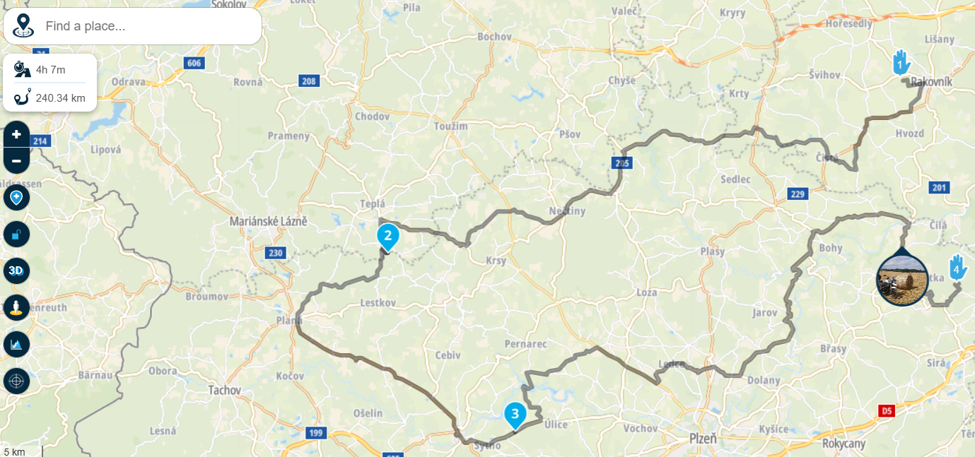
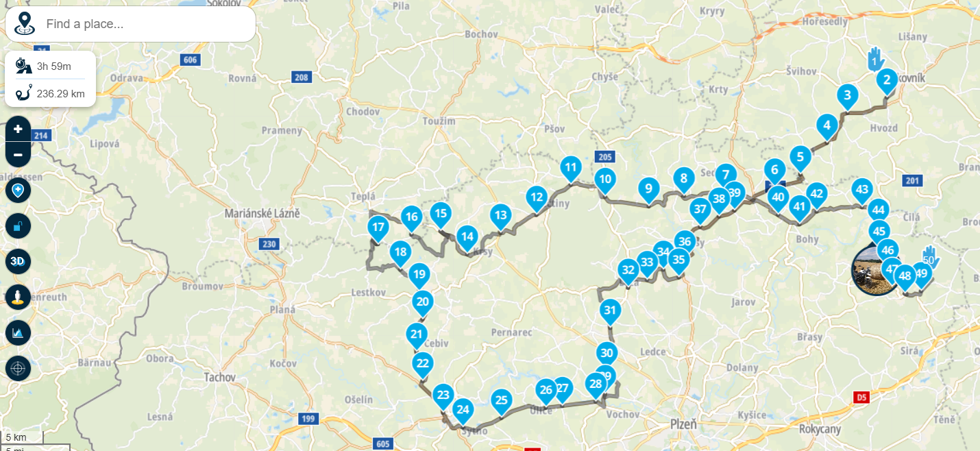
Ahh, thanks, got it. But the "low resolution" track looks pretty detailed -
@Con-Hennekens
Ahh, thanks, got it. But the "low resolution" track looks pretty detailed@Martin-Wilcke said in function EXPAND:
@Con-Hennekens
Ahh, thanks, got it. But the "low resolution" track looks pretty detailedDon´t rely on it looking pretty detailed. It isn´t.
For 1.5 seasons now, I´m using route as track navigation for all of my tours. Yet, there are deviations that I still cannot explain. Yeah, to rise the challenge, I´m also doing it in offline mode, too. I got into some situations, yet always managed to by any obstacles. The point is: use more points! Shaping points, Via points, just use them.
There have been good hints like comparing the route to the other map suppliers, too. Or saving a .gpx from TT, one from OSM, one from HERE or an existing tracklog and adding them to blend in and see what´s really going on. The more effort one puts into planning (and using given tools), the more satisfying the final route will be...
Anyway, have a great (rest of) the season!
By the way: if anybody is interested in my routes and tracklogs, just send me a friendship request. The routes are pretty well described, why many tracklogs are not. My apologies, lack of time b/c I prefer riding. But I guess that I have some interesting stuff available I did through the last years. Covering mostly Italy, France, northern Spain, some Austria, Germany and Czech, too.
-
@Martin-Wilcke said in function EXPAND:
@Con-Hennekens
Ahh, thanks, got it. But the "low resolution" track looks pretty detailedDon´t rely on it looking pretty detailed. It isn´t.
For 1.5 seasons now, I´m using route as track navigation for all of my tours. Yet, there are deviations that I still cannot explain. Yeah, to rise the challenge, I´m also doing it in offline mode, too. I got into some situations, yet always managed to by any obstacles. The point is: use more points! Shaping points, Via points, just use them.
There have been good hints like comparing the route to the other map suppliers, too. Or saving a .gpx from TT, one from OSM, one from HERE or an existing tracklog and adding them to blend in and see what´s really going on. The more effort one puts into planning (and using given tools), the more satisfying the final route will be...
Anyway, have a great (rest of) the season!
By the way: if anybody is interested in my routes and tracklogs, just send me a friendship request. The routes are pretty well described, why many tracklogs are not. My apologies, lack of time b/c I prefer riding. But I guess that I have some interesting stuff available I did through the last years. Covering mostly Italy, France, northern Spain, some Austria, Germany and Czech, too.
I also use "route as track" navigation a lot. The main reason is the lack of a "curviness" option with HERE, so I use TT or OSM for planning instead.
My routes have 3-5 VIAs and a handful of SPs, and I let the routing engine do its job.
As all these roads are typically routable with HERE as well, there's hardly any difference when it comes to navigating the route (as track). And if so, it's easily manageable - the same applies to some erratic behaviour that occurs from time to time (very rarely).It may depend on the areas you're riding, but in my case, this works very well.
Have a great riding season as well!
Hello! It looks like you're interested in this conversation, but you don't have an account yet.
Getting fed up of having to scroll through the same posts each visit? When you register for an account, you'll always come back to exactly where you were before, and choose to be notified of new replies (either via email, or push notification). You'll also be able to save bookmarks and upvote posts to show your appreciation to other community members.
With your input, this post could be even better 💗
Register Login-
09172
-
0431.1k
-
0775
-
010308
-
0347
-
017339
-
06218