Ability to Add Range Markers/colours on route
-
I would like to have the ability to specify the range of my bike in the settings and have MRA automatically change the specified track colours so that looking at a route the colour would change from one colour to another at each point of max range. Say Red and purple?
In other words, for my bike range is 355km. the track would be red for the first 355km track and then change to purple for the following 355km, then back to red for the next segment.
This would make it easy and quick to select a point to search for fuel stations in the planing stage so that a waypoint could be added as necessary. Once a fuel station is added the range segment should restart from that waypoint, etc.
In long distance riding, time is the essence and fuel stop planning is crucial, particular at night when open stations are less available.
Even on a holiday tour, Off-bike time is best spent at an interesting stop, rather than wasted at an unnecessary fuel station.
R1200RS, Nav VI, Zumo XT2, iPhone. — Plot the Track, Go the Distance
-
I would like to have the ability to specify the range of my bike in the settings and have MRA automatically change the specified track colours so that looking at a route the colour would change from one colour to another at each point of max range. Say Red and purple?
In other words, for my bike range is 355km. the track would be red for the first 355km track and then change to purple for the following 355km, then back to red for the next segment.
This would make it easy and quick to select a point to search for fuel stations in the planing stage so that a waypoint could be added as necessary. Once a fuel station is added the range segment should restart from that waypoint, etc.
In long distance riding, time is the essence and fuel stop planning is crucial, particular at night when open stations are less available.
Even on a holiday tour, Off-bike time is best spent at an interesting stop, rather than wasted at an unnecessary fuel station.
@Neil-Bartlett Thanks for clarifying this is about the MRA Routeplanner
") My mind was thinking "if it is so important, just plan your fuel stops" - but you want further assistance in finding the location where you approximately need to find a fuel stop.
My mind was thinking "if it is so important, just plan your fuel stops" - but you want further assistance in finding the location where you approximately need to find a fuel stop.I do applaud the suggestion but I don't think we will add something like this in the near future. I believe there are already some tools available to make this estimation.
-
I would like to have the ability to specify the range of my bike in the settings and have MRA automatically change the specified track colours so that looking at a route the colour would change from one colour to another at each point of max range. Say Red and purple?
In other words, for my bike range is 355km. the track would be red for the first 355km track and then change to purple for the following 355km, then back to red for the next segment.
This would make it easy and quick to select a point to search for fuel stations in the planing stage so that a waypoint could be added as necessary. Once a fuel station is added the range segment should restart from that waypoint, etc.
In long distance riding, time is the essence and fuel stop planning is crucial, particular at night when open stations are less available.
Even on a holiday tour, Off-bike time is best spent at an interesting stop, rather than wasted at an unnecessary fuel station.
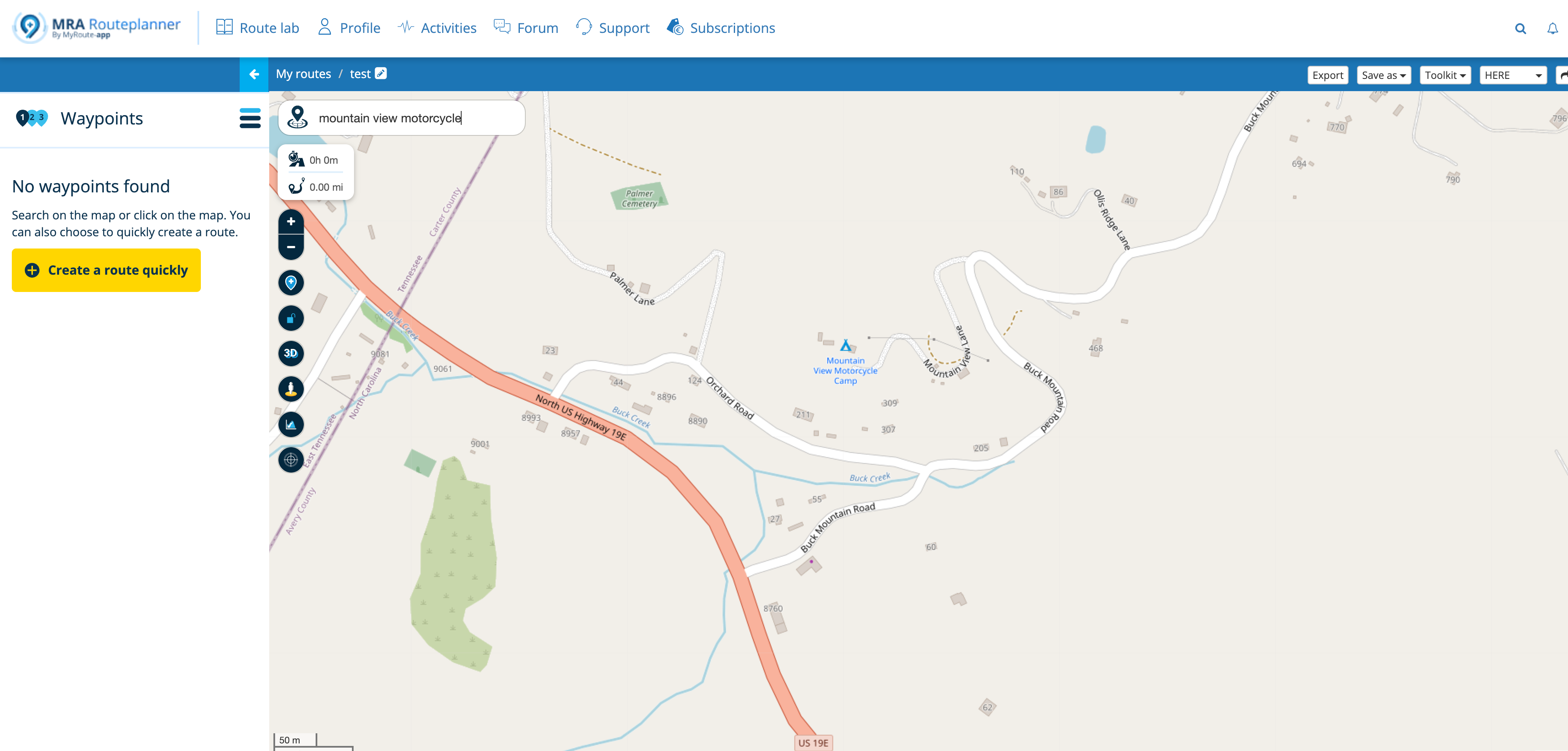
@Neil-Bartlett, the waypoint list shows the distance to any of the waypoints. It is not hard to set and zoom into a waypoint on 355km distance, and enable fuel POI. Or am I missing something?
I am just an enthusiastic MRA user, and hope you will be one too!
Most motorcycle problems are caused by the nut that connects the handlebar to the saddle.
Check out RideSleepRepeat.eu, a biker community for sharing stays across Europe
-
@Neil-Bartlett, the waypoint list shows the distance to any of the waypoints. It is not hard to set and zoom into a waypoint on 355km distance, and enable fuel POI. Or am I missing something?
@Con-Hennekens Yes but that is only applicable if a waypoint happens to fall at a point that equates to your fuel range. Generally, waypoints are not selected based on distance but rather points that are of interest, or that control route objectives.
On distance rides most points are chosen as waypoints by the organisers so that a rider can prove there achieved route by taking a photo at that point. Therefore remote intersections are predominately selected as waypoints. They have nothing to do with individual range.
Even if, instead of the coloured segments based on range that I suggested, MRA allowed you to automatically place a flagged waypoint at each predetermined distance along any imported GPX file that would help. i.e. every 355 km in my case.
Fuel planning is the most time consuming action that has to be taken after inputting a GPX file based on a riders steed [sic] as they are all different and a group has to change fuel stops based on the bike with the least range at any one time.
This is not only for distance riders. Any time a rider plans an impromptu ride of any distance then time can be of essence. It is totally different when out on a casual ride and looking at an low fuel light, deciding to look for the next station as that is well catered for in MRA Navigation search.
What I am talking about is when you have to plan to minimise time wasted by unneeded fuel stops because of range anxiety.
-
@Neil-Bartlett Thanks for clarifying this is about the MRA Routeplanner
My mind was thinking "if it is so important, just plan your fuel stops" - but you want further assistance in finding the location where you approximately need to find a fuel stop.I do applaud the suggestion but I don't think we will add something like this in the near future. I believe there are already some tools available to make this estimation.
@Corjan-Meijerink said in Ability to Add Range Markers/colours on route:
I believe there are already some tools available to make this estimation.
Please explain what tools and how to do this very quickly, that would be helpful.
In my use case we are given a 1600 km long GPX file to import and plan our ride the night before the event. Sorting out minimum fuel stops quickly is important and following the route is compulsory. In Base camp it is relatively easy, if a bit messy. To be able to select the search points visually and quickly in MRA web would be a game changer.
There are hundreds of us in my country doing long distance rides and I am slowly pushing the MRA total package to them as a solution.
R1200RS, Nav VI, Zumo XT2, iPhone. — Plot the Track, Go the Distance
-
@Corjan-Meijerink said in Ability to Add Range Markers/colours on route:
I believe there are already some tools available to make this estimation.
Please explain what tools and how to do this very quickly, that would be helpful.
In my use case we are given a 1600 km long GPX file to import and plan our ride the night before the event. Sorting out minimum fuel stops quickly is important and following the route is compulsory. In Base camp it is relatively easy, if a bit messy. To be able to select the search points visually and quickly in MRA web would be a game changer.
There are hundreds of us in my country doing long distance rides and I am slowly pushing the MRA total package to them as a solution.
@Neil-Bartlett They all kinda revolve around waypoint placement.
But if you indeed do not want to use that as guideline, there are not tools
Under the assumption that nobody needs a fuel accuracy of 10 miles and you place a waypoint at about every ~40 miles minimum, you can actually use waypoints as clear indication
The waypoint list will be your greatest friend!
Optionally you can use the calculator (in toolkit) to get the distance between different waypoints. -
@Neil-Bartlett They all kinda revolve around waypoint placement.
But if you indeed do not want to use that as guideline, there are not toolsUnder the assumption that nobody needs a fuel accuracy of 10 miles and you place a waypoint at about every ~40 miles minimum, you can actually use waypoints as clear indication
The waypoint list will be your greatest friend!
Optionally you can use the calculator (in toolkit) to get the distance between different waypoints.@Corjan-Meijerink To be clear I am not opposed to any idea that will allow me to do this really quickly and efficiently. Nor am I trying to browbeat you guys into fixing it for me. I get that you have time/result imperatives.
Is there a way to specify distance between waypoints as you suggest every 40 miles for example? We don't get to place the waypoints in the GPX file but we can add extra once we import it obviously. Perhaps if I increase the waypoints as per the gold feature I can then use the calculator to get a closer search area, I'll try that with last years route and see how that works.
Yes I do run to ten miles of the range and carry a jerry can, LOL. Its all about time save meaning you can keep the average speed without breaking the legal limits. A refuel can loose 20 minutes if there is a que to pay and we might only have an hour buffer on the finish limit.
Thanks for your input.
R1200RS, Nav VI, Zumo XT2, iPhone. — Plot the Track, Go the Distance
-
@Corjan-Meijerink To be clear I am not opposed to any idea that will allow me to do this really quickly and efficiently. Nor am I trying to browbeat you guys into fixing it for me. I get that you have time/result imperatives.
Is there a way to specify distance between waypoints as you suggest every 40 miles for example? We don't get to place the waypoints in the GPX file but we can add extra once we import it obviously. Perhaps if I increase the waypoints as per the gold feature I can then use the calculator to get a closer search area, I'll try that with last years route and see how that works.
Yes I do run to ten miles of the range and carry a jerry can, LOL. Its all about time save meaning you can keep the average speed without breaking the legal limits. A refuel can loose 20 minutes if there is a que to pay and we might only have an hour buffer on the finish limit.
Thanks for your input.
@Neil-Bartlett said in Ability to Add Range Markers/colours on route:
Is there a way to specify distance between waypoints as you suggest every 40 miles for example? We don't get to place the waypoints in the GPX file but we can add extra once we import it obviously. Perhaps if I increase the waypoints as per the gold feature
As has already been mentioned, the waypoint list shows the distance to each waypoint from the beginning of the route.
After importing the GPX file I would look at the waypoint closest to your tank range and find a fuel station nearby and add a new waypoint there.
I wouldn’t bother with the MRA expand feature.
Hello! It looks like you're interested in this conversation, but you don't have an account yet.
Getting fed up of having to scroll through the same posts each visit? When you register for an account, you'll always come back to exactly where you were before, and choose to be notified of new replies (either via email, or push notification). You'll also be able to save bookmarks and upvote posts to show your appreciation to other community members.
With your input, this post could be even better 💗
Register Login-
1555
-
05112
-
06126
-
0315
-
34112
-
014245
-
07143
-
7211.4k