Strecke ein-/ausblenden
-
Guten Morgen,
ich möchte mich langsam, aber systematisch aufgrund des eingestellten Supports und der fehlenden Weiterentwicklung (Anpassung auf die Apple M-Prozessoren etc.) von BaseCamp trennen. In den letzten Tagen habe ich mich, aufgrund Empfehlungen im gs-forum.eu mit dem MRA Routenplaner beschäftigt und damit einen sehr brauchbaren Ersatz gefunden.Was mich aktuell noch vom Kauf abhält ist der Umstand, dass ich eine gerade in der Planung befindliche Route über einen Button nicht kurzzeitig aus- und wieder einblenden kann – ein für mich sehr wichtiges Argument.
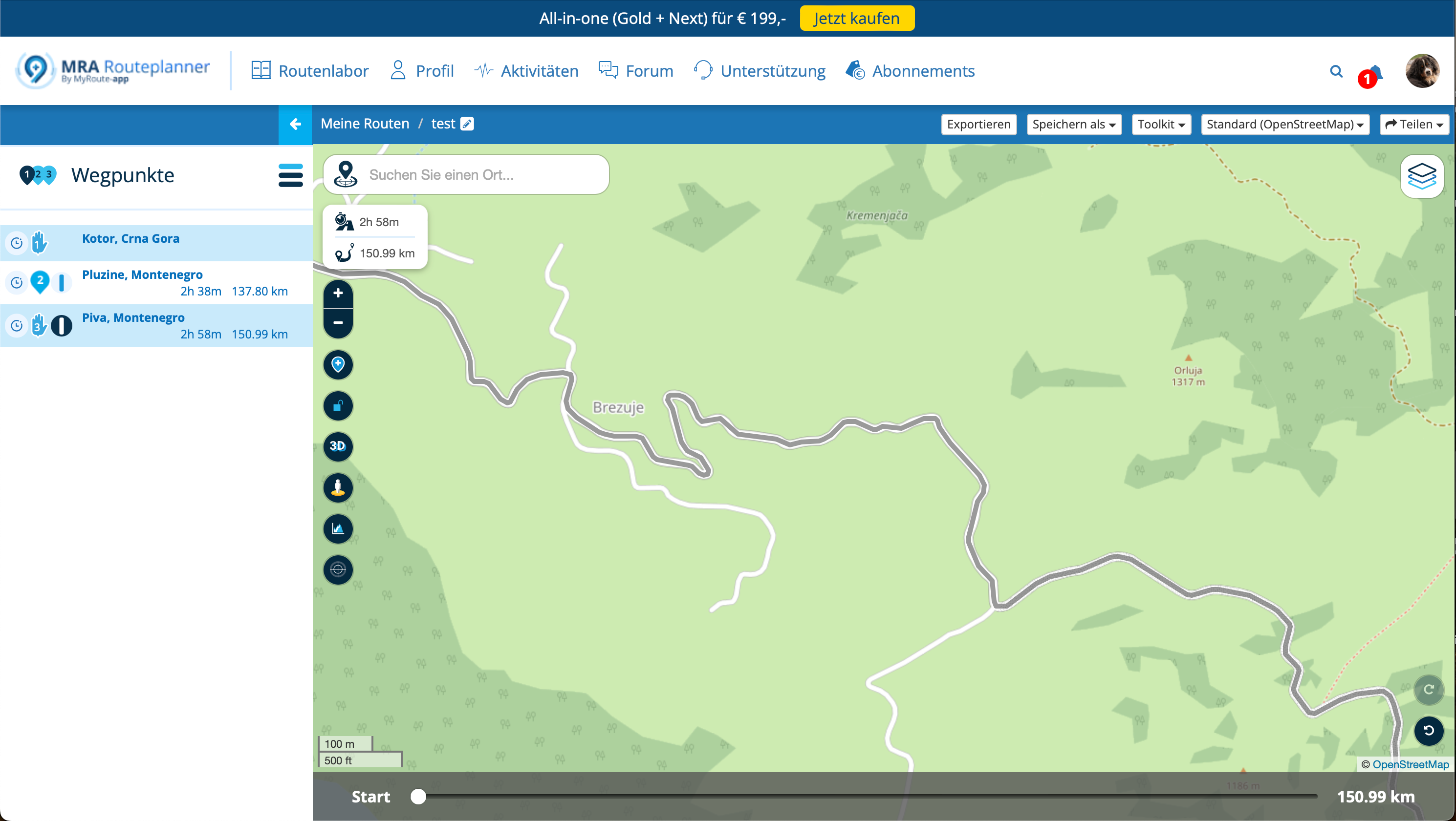
Beim Planen einer Route wird diese ja in Schwarz über das Kartenmaterial gelegt. Leider erkennt man dann oft das darunter liegende Kartenmaterial nicht mehr – was wichtig ist, um zu erkennen, ob es sich eine On- bzw. Offroad-Strecke handelt.
Natürlich könnte man die Transparenz der Routen-Line über das Toolkit-Menü einstellen, je nach verwendeten Kartenmaterial würde dass aber kaum reichen; die Linie würde irgendwann zu blass sein.Beispiel
Hier ein Sreckenverlauf einer geplanten Route – so weit, so gut.
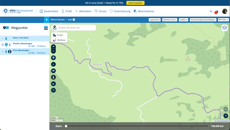
Ab dem roten Pfeil wechselt der Straßenzustand in eine unbefestigte Straße – was mann nur bei genauem Hinsehen erkennen kann.
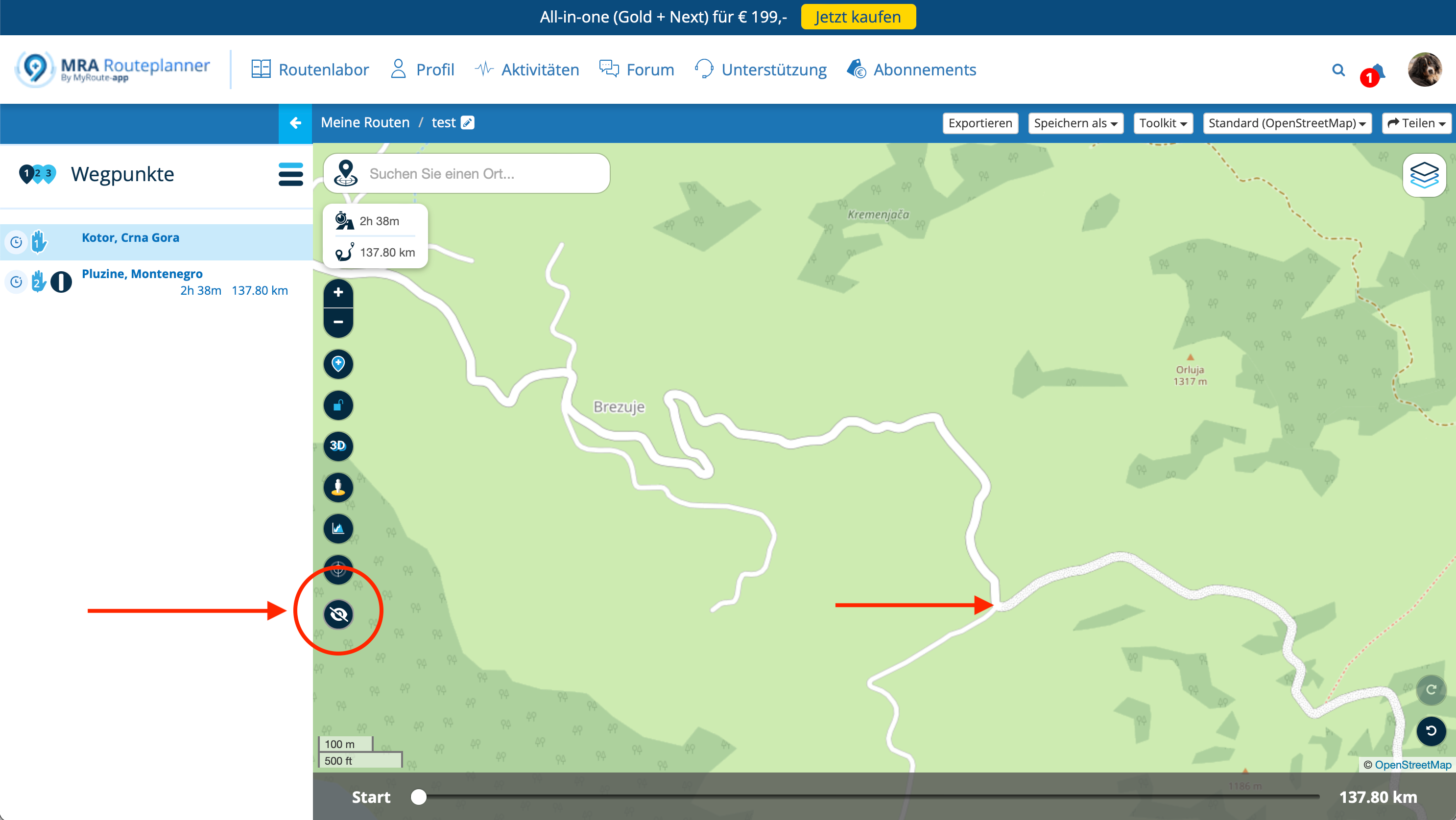
Verbesserungsvorschlag – Könnte man einen zusätzlichen Button einbauen, über welchen man die Routen-Linie kurz aus- und wieder einblenden kann?
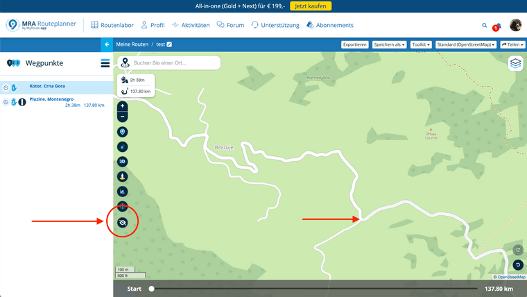
Ich fahre gern Offroad, möchte aber wissen, wo genau die Abschnitte liegen. Wenn eine schwarze Routen-Linie über der Straße liegt, wird dass schwierig und umständlich.
Solch einen Button gibt es zwar auch in Basecamp nicht – hier hatte ich mir aber stets damit beholfen, kurz eine andere "leere" Liste (ohne Touren) zu klicken …
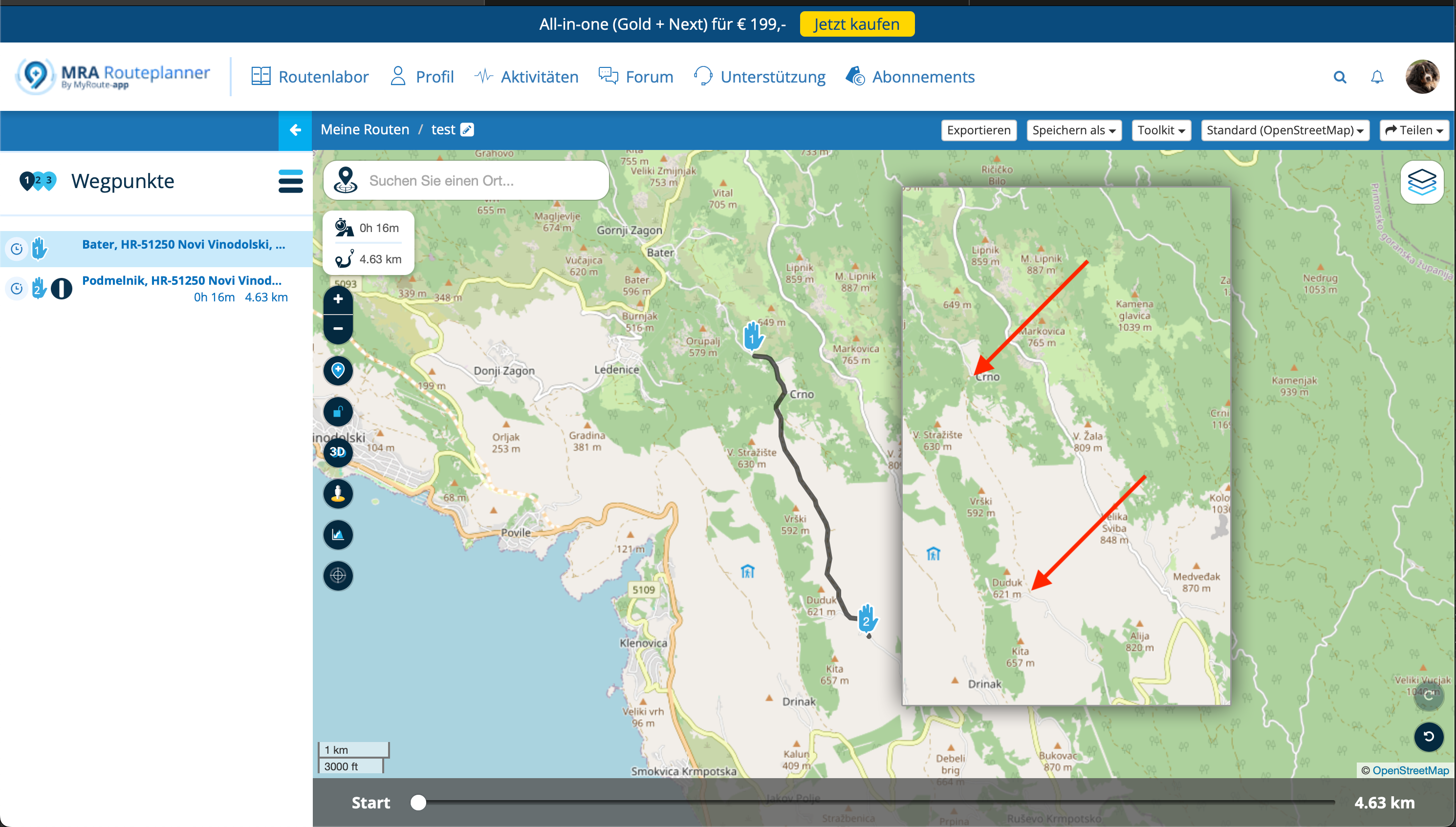
Ein weiteres Beispiel:
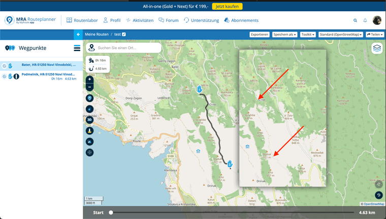
Der Aufwand wäre meines Erachtens überschaubar – die Routen-Linie ließe sich beim Klick auf eine entsprechende Schaltfläche via CSS-Eigenschaft {display:} aus-/einblenden?
-

Hallo Plochi,
das finde ich eine tolle Idee. Ich bin auch immer mal wieder gerne Off-road unterwegs, aber es muss sich in Grenzen halten

Gruß
Thomas -

Ja, hört sich interessant an, der Vorschlag.
-
Ich finde den Vorschlag auch gut. Meine Hoffnung ist, dass das bei der hier auch schon mehrfach diskutierten Überarbeitung des Web-Planungstools berücksichtigt wird.
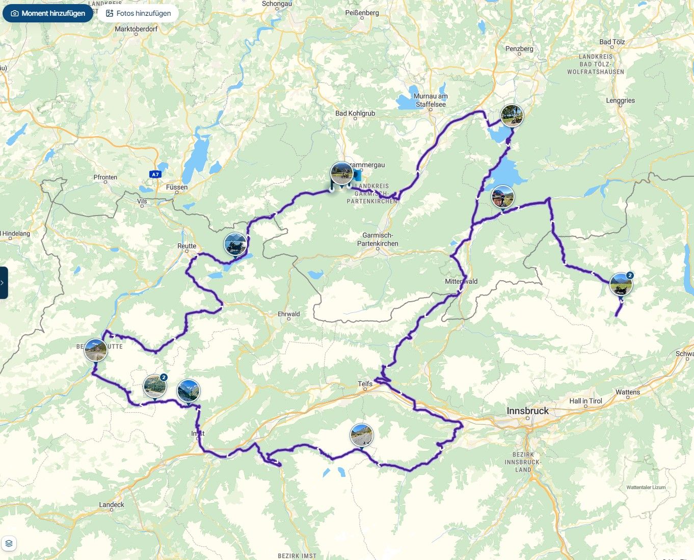
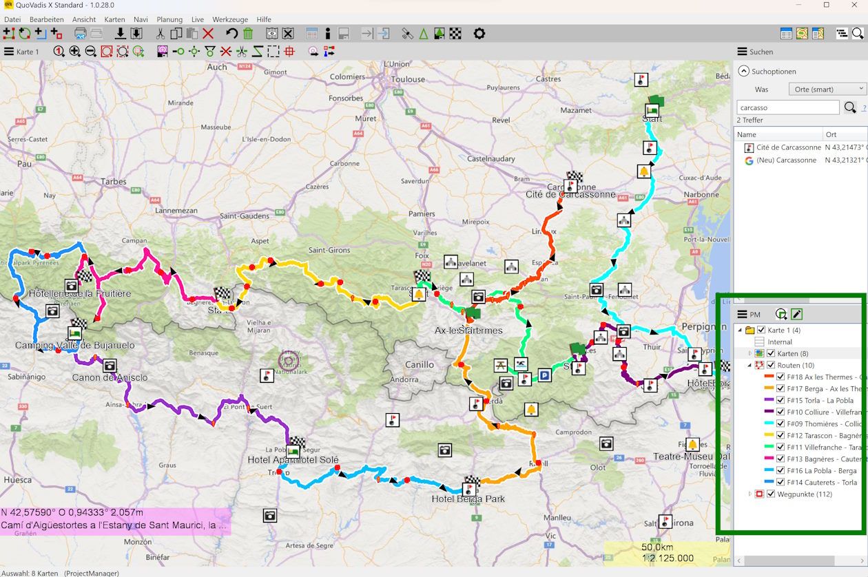
Ich wünsche mir die Möglichkeit, alle auf der Karte sichtbaren Elemente (Routen. Tracks, POI/Wegpunkte/Favoriten) ein- und ausblenden zu können - z.B. so, wie es bei Quo Vadis gelöst ist:
-
Hallo Plochi,
das finde ich eine tolle Idee. Ich bin auch immer mal wieder gerne Off-road unterwegs, aber es muss sich in Grenzen halten
Gruß
Thomas
@TomOnTour said in Strecke ein-/ausblenden:
das finde ich eine tolle Idee. Ich bin auch immer mal wieder gerne Off-road unterwegs, aber es muss sich in Grenzen halten
Dankeschön!
Offfroad ja, aber auch bei mir eher "gemäßigt". Mit einer GS kann man schon viel veranstalten, nur muss ich mir mit 54 nichts mehr beweisen.
Von daher will ich dass, soweit es geht, bei der Planung schon im Vorfeld wissen.@Martin-Wilcke said in Strecke ein-/ausblenden:
Ich finde den Vorschlag auch gut. Meine Hoffnung ist, dass das bei der hier auch schon mehrfach diskutierten Überarbeitung des Web-Planungstools berücksichtigt wird.
Hm – da ich hier noch neu bin – wie lange wird denn hier schon über die Überarbeitung schon diskutiert?
-
Mal zur Info, mit diesem Button;

Kann man einen Beitrag oder Vorschlag mit "GUT" befinden, oder wie heißt es bei Facebook "liken".
Ich glaube, hier nennen sie es Up-Vote. Wie auch immer, je mehr Up-Votes ein Vorschlag hat, desto eher findet er Gehör. -
Ich finde den Vorschlag auch gut. Meine Hoffnung ist, dass das bei der hier auch schon mehrfach diskutierten Überarbeitung des Web-Planungstools berücksichtigt wird.
Ich wünsche mir die Möglichkeit, alle auf der Karte sichtbaren Elemente (Routen. Tracks, POI/Wegpunkte/Favoriten) ein- und ausblenden zu können - z.B. so, wie es bei Quo Vadis gelöst ist:
@Martin-Wilcke
Wow that is impressive.
If MRA could do something similar with regard to the TET Routes that are a combination of On and Off Road routes that would be awesome.
You don’t stop riding when you get old, you get old when you stop riding.
-
@Martin-Wilcke
Wow that is impressive.
If MRA could do something similar with regard to the TET Routes that are a combination of On and Off Road routes that would be awesome.
@Lynchy67 said in Strecke ein-/ausblenden:
@Martin-Wilcke
If MRA could do something similar with regard to the TET Routes that are a combination of On and Off Road routes that would be awesome.
Totally agree.
Just to pursue the idea further, I've added a few sections of the Spanish TET - it could look something like this in MRA in the future:
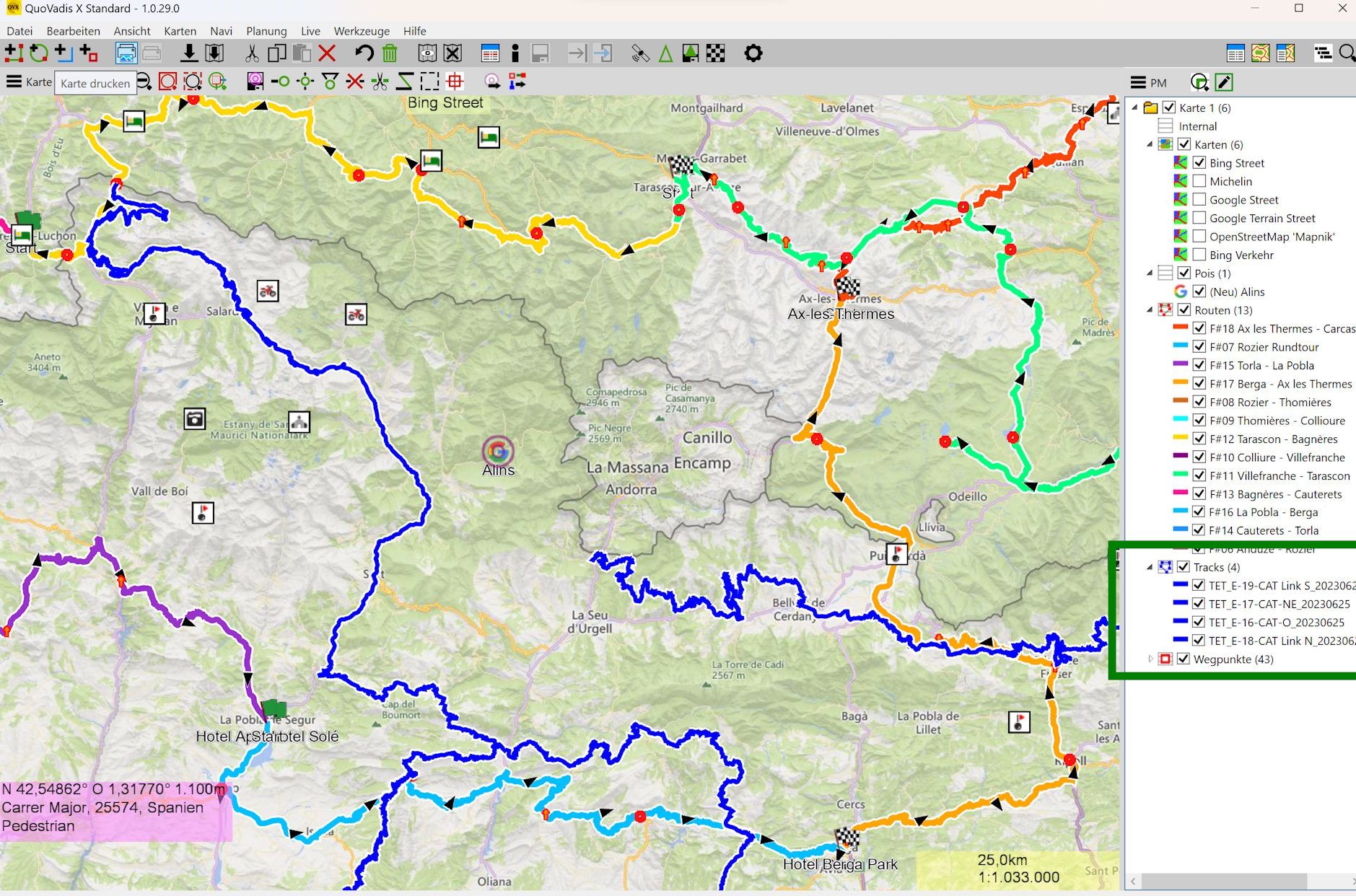
But we always have to remember that additional features always bring additional complexity - and complexity unfortunately quickly leads to more difficult use.
Personally, I have no problem at all with complexity and am prepared to invest the necessary time in familiarising myself with an app. But one of the great things about MRA is its simple and very intuitive usability.
I'm sure the dev team will find the right way and the right balance for further development!
-
@Lynchy67 said in Strecke ein-/ausblenden:
@Martin-Wilcke
If MRA could do something similar with regard to the TET Routes that are a combination of On and Off Road routes that would be awesome.
Totally agree.
Just to pursue the idea further, I've added a few sections of the Spanish TET - it could look something like this in MRA in the future:
But we always have to remember that additional features always bring additional complexity - and complexity unfortunately quickly leads to more difficult use.
Personally, I have no problem at all with complexity and am prepared to invest the necessary time in familiarising myself with an app. But one of the great things about MRA is its simple and very intuitive usability.
I'm sure the dev team will find the right way and the right balance for further development!
@Martin-Wilcke
I'd happily settle on just 2 colours for the TET Routes defining Off Road and On Road.
You don’t stop riding when you get old, you get old when you stop riding.
-
@Martin-Wilcke
I'd happily settle on just 2 colours for the TET Routes defining Off Road and On Road.
@Lynchy67 said in Strecke ein-/ausblenden:
I'd happily settle on just 2 colours for the TET Routes defining Off Road and On Road.
hmmm...
In all the apps I know, the identification of the road surface is part of the map (layer), so that this information is also available without a track/route. This is also how I understood the question or suggestion of the TO: the ability to temporarily hide the route to get a view of the road below.
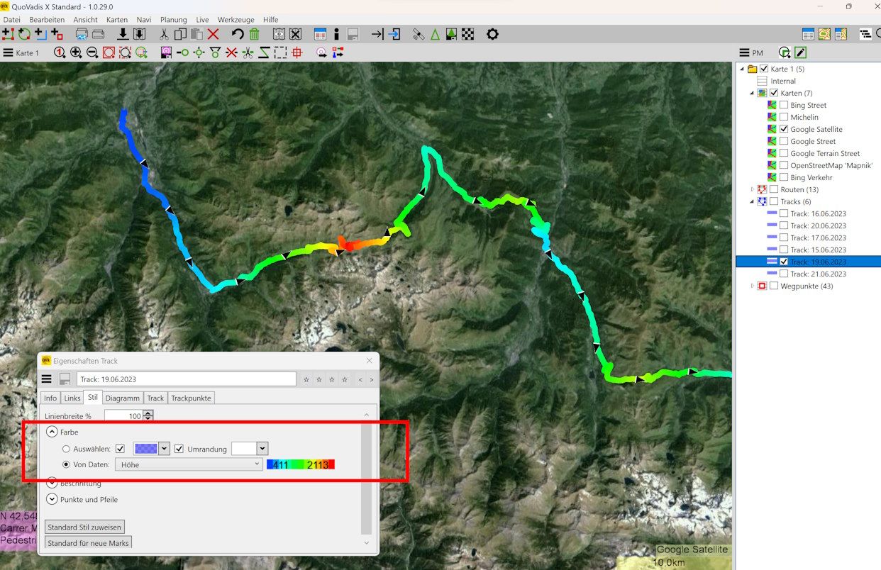
The colouring of a track shows - as I know it - rather the general difficulty (e.g. "blue", "red", "black") for hiking / MTB / skiing or as dynamic colouring the speed travelled or altitude recorded. Of course, the second option only works for tracks that have actually been completed (not just planned).
It could look like this:
But of course the question is whether such functions should really be implemented in MRA or whether special solutions should be used for this purpose.
-
@Lynchy67 said in Strecke ein-/ausblenden:
I'd happily settle on just 2 colours for the TET Routes defining Off Road and On Road.
hmmm...
In all the apps I know, the identification of the road surface is part of the map (layer), so that this information is also available without a track/route. This is also how I understood the question or suggestion of the TO: the ability to temporarily hide the route to get a view of the road below.
The colouring of a track shows - as I know it - rather the general difficulty (e.g. "blue", "red", "black") for hiking / MTB / skiing or as dynamic colouring the speed travelled or altitude recorded. Of course, the second option only works for tracks that have actually been completed (not just planned).
It could look like this:
But of course the question is whether such functions should really be implemented in MRA or whether special solutions should be used for this purpose.
@Martin-Wilcke
Thanks for the further info.
Please feel free to share any Apps you use.
I can see you are using QuoVadis X Standard, i'll check that out.
Hello! It looks like you're interested in this conversation, but you don't have an account yet.
Getting fed up of having to scroll through the same posts each visit? When you register for an account, you'll always come back to exactly where you were before, and choose to be notified of new replies (either via email, or push notification). You'll also be able to save bookmarks and upvote posts to show your appreciation to other community members.
With your input, this post could be even better 💗
Register Login-
 0730
0730
-
0871
-
 81655.5k
-
0282
-
0351
-
 16286
16286
-
 0274
0274
-
1215