Forcing the Zumo XT to go down a road it doesn't recognise
-
So - I am planning a route through a forest and the start of the road I want to travel on (which I know is open) is not recognised on the HERE map. It IS recognised on Open StreetMap and TomTom Map.
I put a shaping point where I know the road starts and another half a mile down the road. Using OSM or TT the route works fine but use Here and the route takes a massive detour to get to the second shaping point. Download to my Zumo and it also takes a massive detour.
I can get round the issue on MRA by selecting SKIP on the second waypoint and MRA straight lines between the two. But download to the Zumo and the massive detour is still there ON THE ROUTE - THE TRACK IS FINE.
I prefer to navigate using routes as I include via points for all the places I want to stop and like being able to see how far or how long to the next via point. Can anyone advise what I need to do to get the Zumo to follow the route I want and effectively straight line between points where it thinks a road doesn't exist?
I thought about turning off unpaved roads in the Avoidances section in Route Preferences but that didn't solve it and I would prefer not to have that selected as I really don't want the Zumo thinking it can really send me off to the wilds to save a minute or two!
Hi Rob, I guess the road is not on the Here-map, or the road is broken. Put a viapoint at the begin and end of that road and drive
Garmin Zumo XT3/XT2/XT/BMW Connected Ride Navigator/Tourstart/ MyRouteapp (The App)/...
Een dag niet gelachen is een dag niet geleefd / Een route is net zo goed als deze uitgezet is. -
Hi Rob, I guess the road is not on the Here-map, or the road is broken. Put a viapoint at the begin and end of that road and drive
@Hans-van-de-Ven-MRA-Master
Thanks Hans - this is what it looks like on the HERE map
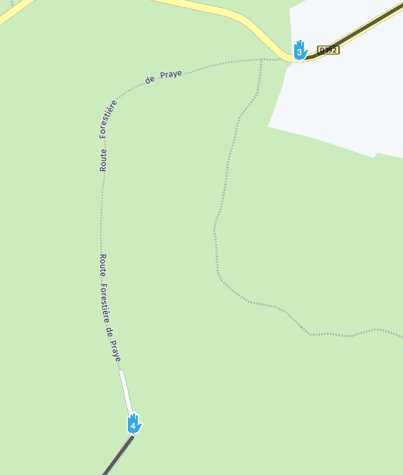
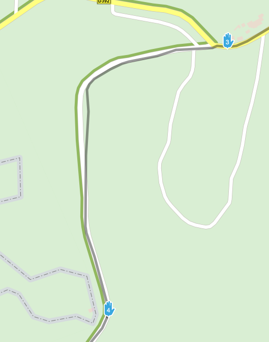
Same road on Michelin with OSM chosen
I've ridden this road before and know it will so its not an issue. But was hoping to find a way for other occasions. But if it can't be done them so be it
-
@Hans-van-de-Ven-MRA-Master
Thanks Hans - this is what it looks like on the HERE map
Same road on Michelin with OSM chosen
I've ridden this road before and know it will so its not an issue. But was hoping to find a way for other occasions. But if it can't be done them so be it
I had this same issue see my replies to this post https://forum.myrouteapp.com/topic/958/mapping-errors/6
And also on here
-
I had this same issue see my replies to this post https://forum.myrouteapp.com/topic/958/mapping-errors/6
And also on here
@stuart-marritt Thanks Stuart. Looks very similar. I don’t however use BaseCamp at all. I do my planning on MYR and then save as GPX 1.1 which I load straight onto the XT.
Just decided to see what happens if I upload as a GPX 1.2. Thats after using the skip waypoint option to straight line across the “broken” road and it works fine. So that may be the answer if you can cope with not having any of the shaping points included.
-
@stuart-marritt Thanks Stuart. Looks very similar. I don’t however use BaseCamp at all. I do my planning on MYR and then save as GPX 1.1 which I load straight onto the XT.
Just decided to see what happens if I upload as a GPX 1.2. Thats after using the skip waypoint option to straight line across the “broken” road and it works fine. So that may be the answer if you can cope with not having any of the shaping points included.
@Rob-Wilkie same here but the issue is to do with the way MRA uses avoidances
Namely State Highways!
Turning this off in basecamp allows you down the road yet you have no option to take it off in MRA
Hello! It looks like you're interested in this conversation, but you don't have an account yet.
Getting fed up of having to scroll through the same posts each visit? When you register for an account, you'll always come back to exactly where you were before, and choose to be notified of new replies (either via email, or push notification). You'll also be able to save bookmarks and upvote posts to show your appreciation to other community members.
With your input, this post could be even better 💗
Register Login-
7713.3k
-
09133
-
120545
-
316915
-
04112
-
05169
-
04101
-
-15206

