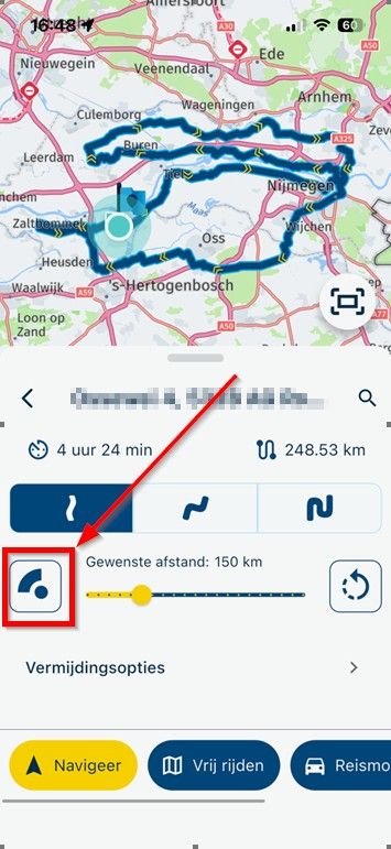
Skip to content

[Web] Problems, Bugs and other Issues

592 Topics 4.3k Posts
  • Google Maps/Street View issues?

    4
    0 Votes
    4 Posts
    70 Views
    Mmm, interesting. After a refresh, it now works again for me as well, although the blue lines from Street View only re-appeared after first clicking somewhere to actually go into Street View. Weird, but glad it works again.
  • Importing a GPX file

    9
    0 Votes
    9 Posts
    432 Views
    Thank you for this derivation and explanation
  • POI Library Question

    9
    0 Votes
    9 Posts
    370 Views
    I'm already looking forward to it when the new WebPlaner appears as an update, some ideas on the subject of POIs are already available and are waiting to surprise us with the ideas in the implementation Some patience is still required, but that will definitely be worth the wait. VG
  • Searching for a route

    12
    1 Votes
    12 Posts
    640 Views
    I can not give you any suggestions for that, other than to organize POI in excel and import it into your own personal library. I know the POI methods in MRA can use some TLC. I just don't want to give you any hope of seeing changes in the current web planner. All efforts will be made in a new web planner, that will definitely take some time before release
  • POI Questions

    6
    0 Votes
    6 Posts
    260 Views
    @Martin-Wilcke said in POI Questions: @Brett-Bartick said in POI Questions: I see the number of entries allowed in the "Points of Interest --> Library" is 50. Is there any particular reason why this limit is set to 50? Where did you get this information? I hit the limit. The MRA application said I couldn't create anymore. "It is not allowed to have more than 50 POI groups. Delete a group and you may add a new one."
  • Problem with shared Routes

    10
    0 Votes
    10 Posts
    629 Views
    Only the MRA sharing within the app or web page to friends, group or in an event delivers 100% of the content that you have created yourself in MRA. For this you always have to use MRA!!! In one of the export files, the additional MRA information such as colors or text info for the WP will be lost. A user gets the best result if he uses the MRA navigation.
  • Anmeldung im Forum geht nicht für neue User warum ?

    5
    0 Votes
    5 Posts
    298 Views
    Niemand zweifelt an den guten Absichten von Hubert oder irgendjemand anderem.
  • Scenic navigatie

    2
    0 Votes
    2 Posts
    154 Views
    Hoi Henry Het is niet perfect maar wel super handig als je snel een route wil hebben die niet over de rijkswegen gaat. Dat het alternatief er langs loopt heeft meer te maken met het gebrek aan alternatieven op die plek
  • kan ik van een route met routepunten weer een track maken?

    3
    0 Votes
    3 Posts
    218 Views
    hi @Conny-v-Staveren zo maak ik een overzicht van een hele roadtrip https://forum.myrouteapp.com/post/70970 this is how I do an overview of a entire road trip https://forum.myrouteapp.com/post/70970
  • Map Routing on Web wont continue along road, starts to backtrack.

    4
    0 Votes
    4 Posts
    341 Views
    Thanks for the response. I will have to Keep that Display traffic option in mind. I usually look at google maps or the state road construction project websites as I am making routes. I did click it but it wasn't showing anything even when I zoomed in. I just tried it again and it took a little for the info to appear but as I was scrolling around the map more and more of the road was showing under construction/closed.
  • Off-road routes?

    4
    0 Votes
    4 Posts
    385 Views
    @Karel76 looks like, you are experienced Yes, I know also Stegra app. Which device are you using fir navigation? I made very good experience with special device for offroaders from DMD; T865-X On this Android based device, I can use MyRoute-App; mostly for ondoad and my self planned routes by MRA-Routeplanner. Parallel, I'm using the app DMD2 from same manufacturer; it's perfect for offroad. Especially because their map contains all offroad pathes, indicated with colour codes - which helps you to decide, if your skills are good enough for this path. Like at MyRoute-App, you can navigate offline, if you have downloaded the needed region map(s) in forefront. Swith to satellite viw is offline not applicable. I love it, to use a gpx file parallel by MyRoute-App and DMD2-App on the same device - just the best app for the current situation.
  • Scroll not working on the phone to add a photo

    6
    0 Votes
    6 Posts
    514 Views
    @Con-Hennekens I tried holding my finger for a couple seconds and eventually got it to scroll. Had to press on the left side. Using Chrome. Thanks for the suggestion.
  • où est passée la personalisation des waypoints ?

    2
    0 Votes
    2 Posts
    294 Views
    @Thierry-LAMBILLARD MRA-Routeplanner ou MyRoute-App? Point de cheminement (point d'itinéraire) ou POI ? Et qu'entendez-vous par personnalisation ?
  • Deviation for an unknown reason

    3
    0 Votes
    3 Posts
    259 Views
    @Brian-McG said in Deviation for an unknown reason: Sometimes you can fix the errors by editing the Here map data at Here Map Creator I have had a look there but cannot work out what the error is, so maybe a report to Here about the problem Yes, that's exactly what I did, and I couldn't find an explanation either. Hence my question
  • change time incorrect

    17
    0 Votes
    17 Posts
    2k Views
    Since I raised this issue, it occurs to me that there are a whole load of apps out there which don’t handle BST and only use GMT. A problem has arisen for me with electric car charging and cheap electricity periods in the U.K. EDF (my electricity supplier) doesn't know when their cheap electricity periods are. They only work on GMT - midnight to 5 a.m…….but in summer this becomes 1 a.m. to 6 a.m. They are going to get back to me to confirm this is actually the case. And then there’s the actual car charger itself which only uses G.M.T. apparently - so I think I’ve been using expensive electricity for an hour every time I charged the car in summer. So, my conclusion is this is now a non-thread, forget I ever started the discussion and close it. Let’s all stick with G.M.T. and get rid of B.S.T.in the U.K. Been interesting though.
  • twee routes tegelijkertijd

    5
    0 Votes
    5 Posts
    553 Views
    @Thijs-Clement when you add the second route you can specify the colour.
  • ik kan niet meer bij de groepen komen geeft een grijze balk

    5
    0 Votes
    5 Posts
    1k Views
    Hij is al haast 2 maanden hier niet meer geweest. Schijnbaar geen urgente vraag (o.i.d.)
  • bug? V 4.4.1 wont open on my Pixel7

    4
    0 Votes
    4 Posts
    661 Views
    No problem mate! Thanks for sharing your solution.
  • Issue to change waypoint colour and icon?

    11
    0 Votes
    11 Posts
    1k Views
    An alle hier wie schon oben erwähnt es ist kein Fehler vorhanden, es war eine falsche Annahme meinerseits, bis ich das Video gemacht hatte und darin gesehen habe was wirklich passiert. To everyone here, as already mentioned above, there is no issue; it was a false assumption on my part until I made the video and saw what really happens.
  • Problem Routeplanner between 2 points

    21
    0 Votes
    21 Posts
    4k Views
    Yes, please don't blame any licensing changes, since there are none. Like @Brian-McG explained, there is likely a difference in versions of the OSM map between the one MRA uses, and OSM has online. @Nick-Carthew said in Problem Routeplanner between 2 points: A Silver subscription only gives you access to the planning map from OpenStreetMap. With the exception of having a Navigation License too.
ACTIVE USERS POPULAR TOPICS MY GROUPS