Skip to content

[App] Suggestions and Discussion

788 Topics 6.1k Posts
  • How can I change the verbal navigation directions from male to female?

    5
    0 Votes
    5 Posts
    59 Views
    Brian McG
    @Marinus-van-Deudekom thanks you are correct there is the option in MRA > Navigation Settings > Audio [image: 1786290582800-629bbab1-d4ad-441e-aea5-94e10e9f7c1d-image.jpeg]
  • Not a great route choice

    Moved
    2
    0 Votes
    2 Posts
    63 Views
    Marinus van Deudekom
    @Hans-Udo-Erdmenger did you check the avoidance settings. It is possible to avoid hiways and bigger roads
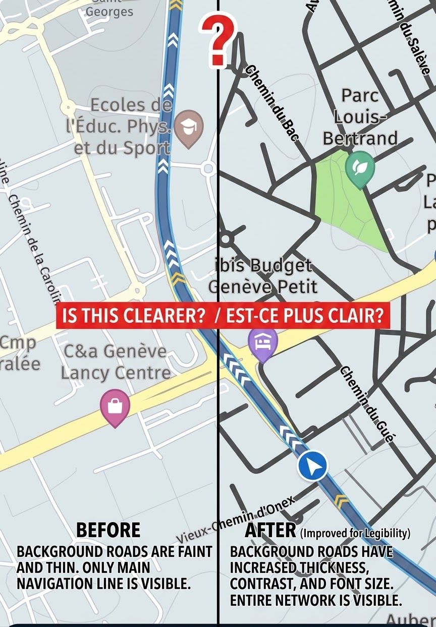
  • Map definition/ clarity

    7
    0 Votes
    7 Posts
    228 Views
    Guzzist
    @LennyO said: @tonyS I use the same combo... yes the maps don't look like Garmin and never will, because that depends on what "Here" gives us. ...also Garmin-XT isn't perfect: the used colours are'nt contrasty enough. I don't understand why every manufacturer uses such pastell colours. Thank God, Garmin uses a simple text file, to define the colours for streets, forests, cities etc. So it's really easy to change used colours to your own preferences. Also to get more contrast Would be nice, if MyRoute-App next would also use such a extra text file to (re)define the map colours...
  • Route spoor gpx

    10
    0 Votes
    10 Posts
    434 Views
    Travellexxie
    Gebeurt wel eens, maar meestal een bewussie
  • Veekeersinfo en omleiden

    Moved
    29
    0 Votes
    29 Posts
    2k Views
    Bouke Ent
    @marko-11-0 Ik rij nu tijdens mijn vakantie routes die ik zelf gemaakt heb en verkeer en afsluitingen worden prima verwerkt, ik krijg gewoon omleiding... nogmaals ik heb geen route punten (viapunten) staan in het afgesloten gedeelte en ik heb navigatie op online staan. normaal rij ik offline maar het was nu te kijken of het werkte. dus als je zelf een mooie route maakt en je rijd online dan kon je geen geregistreede afsluitingen tegen. je kan nog steeds ongeregistreede afsluitingen tegenkomen zoals een dorpsfeest maar die hebben meestal lokale omleiding. In de huidige situatie is het dat als je de route generator gebruikt en je kies voor welkje bochtige optie dan krijg je geen route maar een track. je hebt een punt als je zegt waarom word daan bij generatie niet gekeken naar afsluitingen. ik zelf gebruik deze optie zelden. in de webomgeving kan je de track omzetten naar een route en met de verkeerslaag controleren of er eventueel rare dingen in zitten. inprincipe zou de omgezetten track naar route wel om moeten gaan met wegafsluitingen.
  • Track vs Route

    10
    0 Votes
    10 Posts
    660 Views
    Roger Needham 0
    Gotcha…thanks Peter I know of a couple of local spots where MRA, Google etc ‘think’ there are roadworks. Either because there have been past roadworks now cleared away, or upcoming roadworks that have been announced, uploaded into planning software, but not yet physically introduced. In those cases I’d be happy to do as you suggest
  • MRA App und Caretta von Carpe Iter arbeiten nicht zusammen

    3
    0 Votes
    3 Posts
    150 Views
    Fran S
    @M.-Schrijver Laut Carpe Iter, an die ich meinen (Index-)Rapport von meinem Caretta kopiert und per Mail geschickt hatte, liegt das Problem eindeutig bei MRA. Ich bin eigentlich sehr zufrieden mit MRA und ich liebe wie einfach es ist eine Route zu planen aber während Carpe Iter, so habe ich es zumindest immer wieder erfahren, immer schnell mit einer Antwort oder Lösung zur Stelle ist, lässt MRA auf sich warten. Ich kann mein MRA daher immer noch nicht auf meinem Caretta benutzen. Eigentlich sehr schade. MRA mag es offenbar auch nicht, wenn man Fragen auf derenFacebookseite stellt und um Hilfe bittet. Also. Nochmal; Carpe Iter's Produkt und service is wirklich freundlich, schnell und gut und kann ich nur Empfehlen. Ich hoffe dass das bei MRA auf kurzer Sicht auch bald eine Positive Nachricht und Losung gibt.
  • Breadcrumbs always ON option

    3
    0 Votes
    3 Posts
    175 Views
    Stevedo 6 0
    Yes, you can get the tracklog to start automatically as @nick-carthew points out. However, be aware of the following: "We will automatically start your tracklog when navigating! For simple A to B routes, you still need to do this yourself." This is a quote from within the app. when you press the "i" button. Just a heads up
  • Download itn,gpx etc on android app - Folder location

    5
    0 Votes
    5 Posts
    326 Views
    Peter Zehentreiter
    @Marinus-van-Deudekom @bfg He will probably click the “Download” button first, after which the file will be saved directly to the MRA app's download folder. He must first click “Export” and then tap “Share”; he can then select the Android download folder or Google Drive.
  • v5.2 (473) Feedback

    Moved
    15
    1 Votes
    15 Posts
    1k Views
    C.A. Kielen
    Ik heb de route-omleidingsoptie regelmatig moeten gebruiken, en dat werkte perfect. Wel had ik de laatste week wat problemen in zuid Engeland: mogelijk zijn er een gedeelte of allemaal intussen opgelost of lag het aan een fout inde route file: tracklog neem niet op. de positie indicator loopt achter. Geluids-instructies kwamen wel op tijd. scherm draait op zijn kop bij iedere stop, dus ook voor stoplicht. Gaat aan de hand van de nieuwe richting ook de route herberekenen. Slaat ongevraagd via routepunten over. Zou niet mogelijk moeten zijn, maar het gebeurde wel. Melding: "kan route niet herberekenen" blijft eindeloos langskomen. 50 meter verderop kan hij het ineens wel herberekenen. 6.Eindeloos schakelen van online naar offline en weer terug, terwijl ik prima ontvangst had op de telefoon. Ook melding geen internet. Van al deze fouten heb ik aan deze kant van het Nauw van Calais niets gemerkt (andere routefile). Alleen van punt 3 weet ik dat niet zeker. Kan dit alles aan een fout in de route file hebben gelegen?
  • Windroos foutief

    5
    0 Votes
    5 Posts
    273 Views
    De Ploey Georges
    Ah ok, bedankt allen 🫣 dan klopt het
  • Restart route: option to navigatie to nearest point on route

    20
    0 Votes
    20 Posts
    1k Views
    Gerard Wullink
    Ah! Thats new to me, thanks for the explanation!
  • Unknown symbol

    9
    1
    0 Votes
    9 Posts
    675 Views
    Travellexxie
    @richtea999 no no, it is definitely sh*t, but I think it is not from a bear, because they are very rare in the Netherlands (where they develop MRA) . My educated guess would be a beaver!
  • Repeat the last instruction?

    5
    0 Votes
    5 Posts
    330 Views
    LennyO
    @Con-Hennekens, @peter-zehentreiter Awesome! Thx!
  • Reading out the name of the waypoint and associated notes

    Locked
    43
    0 Votes
    43 Posts
    3k Views
    LennyO
    @Peter-Zehentreiter Well, Peter..... It is a bit far fetched for you to assume how i ride, where i ride, who i talk to and what i am paying attention to..... You are almost accusing me of being an unsafe rider! Are you telling me that you do not look at the screen of your nav while riding ....????? Come on! You just pay attention to the road and navigate by listening to voice directioins from your Nav...???? That's funny, man! Ok, let's end this discussion with "we agree to disgree"!
  • Hoogte meters in Navigatie

    2
    0 Votes
    2 Posts
    189 Views
    Corjan Meijerink
    Sinds de introductie van de functionaliteit kan je het al uitzetten. Gewoon daar waar je alle visuele instellingen kunt wijzigen
  • Quickly rename route/track in the routes/track-screen

    5
    0 Votes
    5 Posts
    382 Views
    Stevedo 6 0
    @Leike-Lodiers I thought that's what @sjoerd-spieker said in his original post!
  • Synchronise a folder. Is it possible.

    13
    0 Votes
    13 Posts
    684 Views
    Leike Lodiers
    Just created some routes for a friend and placed them in a map and they sync pefect to my phone. I must admit the list off routes is getting very long even i use a lot off maps to sort them. I keep my root directory clean. When i want to use a ride i place it in the root directory of MRA so i always can find it easy. But maybe a option which route a want to sync isn't a bad idee.
  • A simplified navigation-only tutorial

    18
    7 Votes
    18 Posts
    804 Views
    peha
    @Anonymouse Thanks for your detailed response. Sounds like you know what you are doing, and the results certainly demonstrate it. Well done!
  • In screen 'Routes & tracklogs' show distance (or time) next to routename

    3
    0 Votes
    3 Posts
    250 Views
    Sjoerd Spieker
    Yes, that's the method I do use now. It does have the advantage that you can round the distance to a nicer number. Eg. 150km instead of 146km, so you kind of categorize them by length. So I agree you have a point there.
ACTIVE USERS POPULAR TOPICS
MY GROUPS