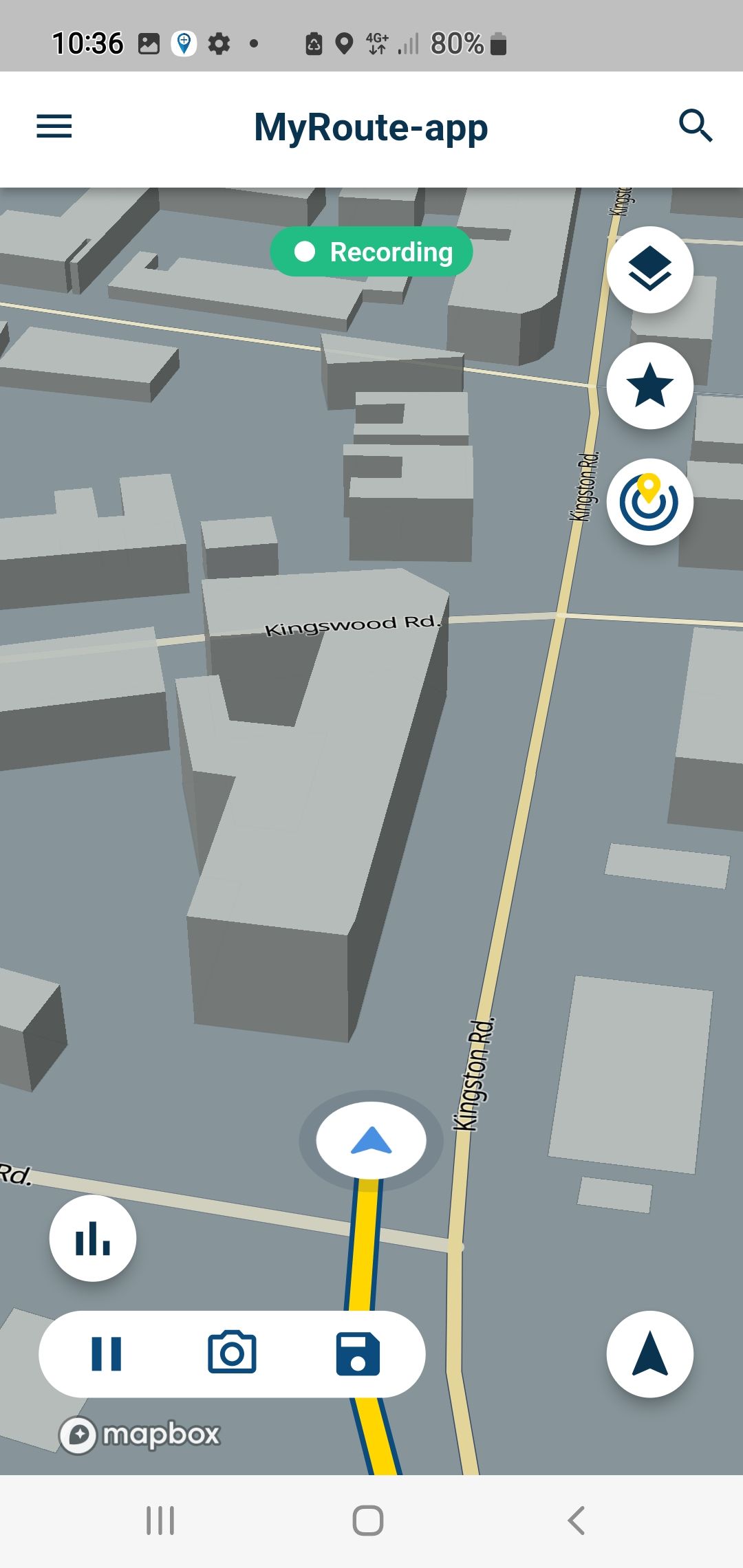
Skip to content

[Beta] Suggestions and Discussions

796 Topics 5.3k Posts
  • Suggestion: favorite features screen

    Moved suggestion options next
    7
    0 Votes
    7 Posts
    96 Views
    @Timo-Martosatiman-MRA said in Suggestion: favorite features screen: there should be a default one yes, of course as long as I as a user, can drop these standard features and drag/drop others in it. Important would be that the features in this widget screen do not require any other input than a simple push. This is to be used while driving so no time for entering parameters.
  • How do you become a Beta tester?

    Moved question betatesting
    6
    0 Votes
    6 Posts
    138 Views
    We're researching this possibility right now. I've talked with our well-known developer @Corjan-Meijerink about the possibilities on this as well to streamline an internal beta for the team. Know that we're on this and will come up soon with more information on this matter.
  • Suggestion: Next petrol station...

    Moved suggestion next petrol station on route
    2
    0 Votes
    2 Posts
    71 Views
    Hi Spili, we have this feature planned in our list of features. More to follow in the future. We want to ensure that you're both getting a relevant petrol station (so not one that is behind you, like many other apps do) and close enough. This feature is in it's design stage still, but we've got it scoped. Thank you for participating!
  • Emergency button/Noodknop

    Moved suggestion noodknop next
    4
    0 Votes
    4 Posts
    56 Views
    @Jan-Weerheim Heel goed idee, en verdorie nuttig ook. een mogelijkheid om deze coordinaten in een goed formaat te kunnen pasten naar een email ed zou ook nuttig zijn.
  • Favorites for navigation

    Moved
    4
    0 Votes
    4 Posts
    57 Views
    @M-Schrijver This will be available in MRA Navigation Next, for example see the MRA Mobile app
  • Fase 01: 01 september - 01 januari 2023

    Moved
    18
    2 Votes
    18 Posts
    230 Views
    @Michel-van-Hagen-MRA-Founder, ik ben blij met deze landscape oriëntatie! Tip is wel om alle data verleden aan één zijde te plaatsen, en transparant te maken.
  • Introduce!

    Moved
    17
    0 Votes
    17 Posts
    149 Views
    Mijn navigatiewensen: op de motor (Garmin Zumo en/of smartfoon), in de auto (Garmin Zumo, Apple Carplay en/of smartfoon) én op de fiets. (Garmin GPSmap 64s en/of smartfoon) My navigation needs: on the bike (Garmin Zumo and/or smartphone), in the car (Garmin Zumo, Apple Carplay and/or smartphone) and on the bike. (Garmin GPSmap 64s and/or smartphone)
  • 0 Votes
    11 Posts
    147 Views
    @Timo-Martosatiman-MRA said in Suggestion: Navigatie voor fietsen en wandelen zou een waardevolle toevoeging aan de app zijn.: Hoi Hans, een leuke aanvulling die we al jaren op het oog hebben. We willen ook de recreatieve wandelaar/fietser op MyRoute-app een thuis geven. Daarom hebben we in mobile het nu de OpenCycleMap toegevoegd. Dat zal ook zo blijven als je straks Navigation Next gebruikt. Hi Hans, a nice addition that we have been eyeing for years. We also want to give the recreational walker/cyclist a home on MyRoute-app. That is why we have now added the OpenCycleMap in mobile. This will also remain the case if you use Navigation Next. Hey, Wil dit dan zeggen dat je met de next navigation een fietskaart kan laden? Of er toch gebruik wordt gemaakt van fietswegen. Ik heb met de huidige mobile app de fietsroute voor werk eens toegevoegd met de cycling map, hier neemt deze zoals komoot perfect de fietssnelwegen. Als ik navigeer van A naar B zonder route vooraf te plannen/track neemt deze de gewone auto wegen terwijl het dan best is de fietsroutes/ fietssnelwegen te nemen zoals op de cycling map. Misschien een mogelijkheid om verschillende kaarten te gebruiken bij het navigeren? Aan de hand van het gekozen voertuig.
  • Navigation observations/questions...

    Moved suggestion next navigation
    2
    1 Votes
    2 Posts
    62 Views
    So it appears that I got an answer about my observations on #1 and #2 here... Navigation with waypoints It appears that my observations were correct. I'm good with #1. Disappointed with #2. On the upside, it appears that #2 is going to be addressed in Next. Great. As to #3, assuming that my observations were correct, I hope it will also be addressed in Next.
  • 0 Votes
    11 Posts
    122 Views
    @Nick-Carthew said in Suggestion: Expand Waypoint Color Palette and Pause Symbol Options: @Tim-Thompson said in Suggestion: Expand Waypoint Color Palette and Pause Symbol Options: I appreciate the current implementation for it's simplicity and there's good arguments for keeping it that way. However, I still find myself wanting a little more occasionally. Take the color choices for example... I tend to use green for the route start and red for the route end. That leaves me 3 colors to choose from for all else. Blue I consider to be the default, so now I'm down to two - yellow and pink(?). It might be nice to have just a few more choices. On the pause symbols... I can get by with the current choices fine. I generally only use Fuel, Food, and Viewpoint. I might occasionally use Drinks, although I generally don't drink much while riding. I use Viewpoint as a catchall - signifying anything that might be something you stop to see or do. It might be nice to have a few more options here. But not a big deal. I can live with what there is. Hi @Tim-Thompson The problem with using the green for the start and the red for the finish is; you only get to use those two colours once, so I can see why you would want a larger palette. The RouteXpert colour key seems to work ok why not give it a go: Blue: Just used for shaping the route. Yellow: We use this as an indicator that from that exact spot, something can be seen. This could be a castle on a hill, a waterfall or a prominent mountain on the skyline. Green: This is used to show great places to stop for photos (used in conjunction with a camera icon and generally a 10 minute pause break). Red: This has several uses but it always indicates a stop. This could be a fuel stop, coffee/lunch stop or a stop to visit an attraction like a museum. Suitable icons and pause breaks are added. Pink: This also has several uses, but they will all be for information. This could just be general information about the area, or an option to take an alternative route. We also use pink along with the warning triangle icon to warn of any hazards like unprotected mountain roads or a series of tight hairpin bends. In addition to this we generally use via points for green and red route points.. That's certainly one way of doing it. But it shouldn't be the only. I think this is dependent on how things work best and seem most logical for the individual user. Again, you don't want to force/constrain the user into a use case that isn't logical or intuitive to them because of the limitation of the tool. Personally... I use Yellow for fuel stops. Yellow stands out and it's something that I don't want to miss. I like Green and Red for the beginning and end because they catch my eye and I can quickly recognize them for what they are immediately upon opening/viewing the route on a map. I use pink for stops - whatever kind of stops they may be - because it's sort of reddish (reddish for intermediate vias/stops) and because it's the only option left. Is my way of thinking about color use right? For me maybe, but maybe not for others. Flexibility and (enough) options seems good here.
  • 0 Votes
    5 Posts
    70 Views
    @Hans-van-de-Ven-MRA-Master said in Suggestion: Interoperability/Integration with other route planners: @Tim-Thompson Hi Tim, Why? MRA has everything in-house, why would you create a route in another application? No offense here Hans, but the word that immediately jumped into my mind when reading this was "myopic". As I've mentioned before, I don't use MRA as my primary route planner. I disagree with your viewpoint that MRA has it all - eliminating the necessity for any other. I'm not wedded to any platform. I tend to look at - and run through their paces - as many options as time allows. What I end up using in the end depends on which one (or ones) best accomplishes - in my view - what I need from it (or them). There are - in my view - other options that are both more useful and more capable for route planning than MRA (in particular in meeting the needs that are important to me). Don't get me wrong, I think MRA is a decent option for what it is, but I don't think it's the be all - end all.
  • Fase 04: 1 mei 2023 - 1 juni 2023

    Moved
    4
    3 Votes
    4 Posts
    116 Views
    @Michel-van-Hagen-MRA-Founder How about Aus/NZ?
  • Suggestions

    Locked Moved
    45
    0 Votes
    45 Posts
    489 Views
    Woosh. Topic is now locked. Please refer to the amended rules on page 1. i.e: make new topics for suggestions so we can keep it organized. Thanks!
  • Off topic

    Moved
    11
    0 Votes
    11 Posts
    115 Views
    @Eric-Bovelander Google eens op "knoop kompas". Ze zijn er te kust en te keur. Om globaal de windrichting te kiezen is een eenvoudig dingetje al voldoende. Zeker op de motor. Je plakt hem eenvoudig ergens in het zicht.
  • Fase 03: 1 maart - 1 mei 2023

    Moved
    1
    3 Votes
    1 Posts
    55 Views
    No one has replied
  • Fase 02: 01 januari - 1 maart 2023

    Moved
    1
    2 Votes
    1 Posts
    67 Views
    No one has replied
ACTIVE USERS POPULAR TOPICS MY GROUPS