MRA-Routeplanner - distance simulation
-
In MRA-Routeplanner, there is a base line down in the screen (for Route and for Track) - with a slider button, to simulate the distance from starting point.
If sliding the button, the distance will be shown in Km/Miles, the map moves accordingly and a red dot displays exactly the position for the selected distance.
That's ok.Now the question for enhancemet: would it be possible, to populate additionally to the distance in Km/Miles also the time in hrs:minutes from start to selected position?
For routes, it will help to plan p.e. stopps or coffe brakes after a dedicated time of ride.
For recorded tracks, it will help in recap to see, at which point did we stay at p. e. 12:00.Nothing is impossible ;-)
In past: GARMIN Zumo 210->GARMIN Zumo 395->GARMIN XT=> now: DMD T865-X + MyRoute-App, LocusMaps, OsmAnd.
In past: GARMIN MapSource ->GARMIN BaseCamp->Tyre->Kurviger->Calimoto=> now: MRA-Routplanner. -
In MRA-Routeplanner, there is a base line down in the screen (for Route and for Track) - with a slider button, to simulate the distance from starting point.
If sliding the button, the distance will be shown in Km/Miles, the map moves accordingly and a red dot displays exactly the position for the selected distance.
That's ok.Now the question for enhancemet: would it be possible, to populate additionally to the distance in Km/Miles also the time in hrs:minutes from start to selected position?
For routes, it will help to plan p.e. stopps or coffe brakes after a dedicated time of ride.
For recorded tracks, it will help in recap to see, at which point did we stay at p. e. 12:00.@Guzzist said in MRA-Routeplanner - distance simulation:
For routes, it will help to plan p.e. stopps or coffe brakes after a dedicated time of ride.
Surely this is not your entirely regarding your initial question concerning the slider, but one can also acquire the info you like from the waypoint list!? Whenever you set the departure time for your route appropriately, the waypoint list shows the time when you are at a certain waypoint after a certain distance. See screenshot below.
You are aware of this functionality?

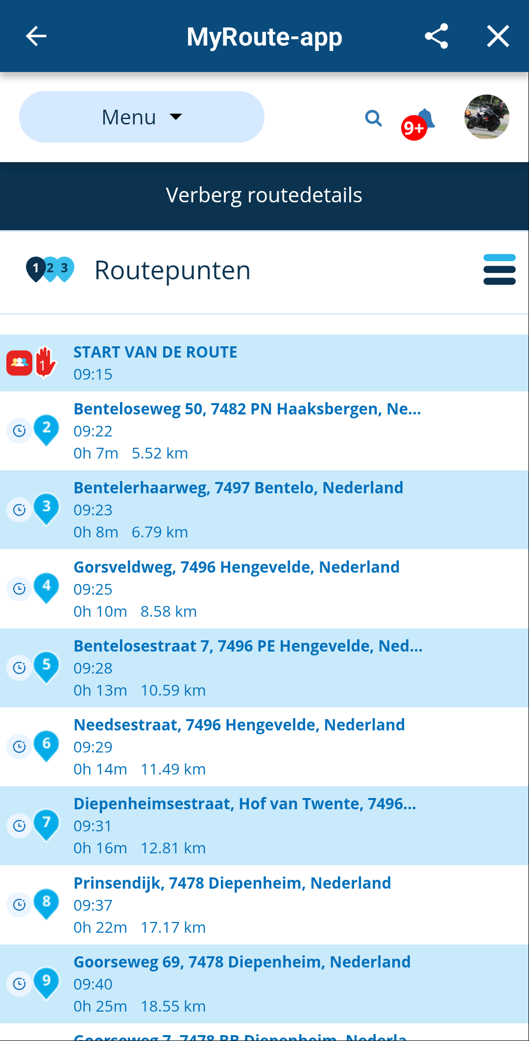
You might even additionally use the built-in calculator from the toolkit menu, to calculate distance and time between waypoints, in the case you are not capable of doing it by head.
Manks bu'j te bange.
-
@Guzzist said in MRA-Routeplanner - distance simulation:
For routes, it will help to plan p.e. stopps or coffe brakes after a dedicated time of ride.
Surely this is not your entirely regarding your initial question concerning the slider, but one can also acquire the info you like from the waypoint list!? Whenever you set the departure time for your route appropriately, the waypoint list shows the time when you are at a certain waypoint after a certain distance. See screenshot below.
You are aware of this functionality?
You might even additionally use the built-in calculator from the toolkit menu, to calculate distance and time between waypoints, in the case you are not capable of doing it by head.@Stefan-Hummelink said in MRA-Routeplanner - distance simulation:
@Guzzist said in MRA-Routeplanner - distance simulation:
For routes, it will help to plan p.e. stopps or coffe brakes after a dedicated time of ride.
Surely this is not your entirely regarding your initial question concerning the slider, but one can also acquire the info you like from the waypoint list!? Whenever you set the departure time for your route appropriately, the waypoint list shows the time when you are at a certain waypoint after a certain distance. See screenshot below.
You are aware of this functionality?
You might even additionally use the built-in calculator from the toolkit menu, to calculate distance and time between waypoints, in the case you are not capable of doing it by head.I think you misunderstood @Guzzist request. If you have lots of waypoints in your trip then it would be easy using the list you showed to calculate gas stops. But if you input the start and end points that are very far apart there is no easy way to calculate gas range for gas stops. My motorcycle has a range of 200 miles before I need to start looking for gas. If my trip is 1000 miles I would need ~ 5 gas stops. There is no way within the online planning to add those without just dropping and deleting a pin until it gets close. The slider is currently useless for my planning. But if it had a scale of mile/KM then it would be useful for planning stops. Some examples, Garmin Basecamp shows the current range from start when you hover the mouse pointer over the route. Inroute allows the user to place a waypoint every X miles/KM. The user can then add a fuel location near the incremental waypoint.
-
@Stefan-Hummelink said in MRA-Routeplanner - distance simulation:
@Guzzist said in MRA-Routeplanner - distance simulation:
For routes, it will help to plan p.e. stopps or coffe brakes after a dedicated time of ride.
Surely this is not your entirely regarding your initial question concerning the slider, but one can also acquire the info you like from the waypoint list!? Whenever you set the departure time for your route appropriately, the waypoint list shows the time when you are at a certain waypoint after a certain distance. See screenshot below.
You are aware of this functionality?
You might even additionally use the built-in calculator from the toolkit menu, to calculate distance and time between waypoints, in the case you are not capable of doing it by head.I think you misunderstood @Guzzist request. If you have lots of waypoints in your trip then it would be easy using the list you showed to calculate gas stops. But if you input the start and end points that are very far apart there is no easy way to calculate gas range for gas stops. My motorcycle has a range of 200 miles before I need to start looking for gas. If my trip is 1000 miles I would need ~ 5 gas stops. There is no way within the online planning to add those without just dropping and deleting a pin until it gets close. The slider is currently useless for my planning. But if it had a scale of mile/KM then it would be useful for planning stops. Some examples, Garmin Basecamp shows the current range from start when you hover the mouse pointer over the route. Inroute allows the user to place a waypoint every X miles/KM. The user can then add a fuel location near the incremental waypoint.
@Ronnie-Moore said in MRA-Routeplanner - distance simulation:
I think you misunderstood @Guzzist request.
I absolutely understood his request, as I specifically mentioned in my first sentence that the method I mentioned ALSO can do the trick he intents to do with the slider if it would have that data.
I have read back my sentence and I agree I forgot some words, but I tried to offer an alternative that for me does the same thing. I need to get fuel every 200km, instead of 200miles and I can also manage the fuel stops quite efficiently. Surely, this method may not be of your liking, but it does the trick. That does not mean I do not see the benefit of a "hover-over the route line"-ish info tool. -
@Guzzist said in MRA-Routeplanner - distance simulation:
For routes, it will help to plan p.e. stopps or coffe brakes after a dedicated time of ride.
Surely this is not your entirely regarding your initial question concerning the slider, but one can also acquire the info you like from the waypoint list!? Whenever you set the departure time for your route appropriately, the waypoint list shows the time when you are at a certain waypoint after a certain distance. See screenshot below.
You are aware of this functionality?
You might even additionally use the built-in calculator from the toolkit menu, to calculate distance and time between waypoints, in the case you are not capable of doing it by head.said in MRA-Routeplanner - distance simulation:
Surely this is not your entirely regarding your initial question concerning the slider
Which had to be:
"Surely, my following suggestion is not concerning your initial question regarding the slider"
-
@Stefan-Hummelink said in MRA-Routeplanner - distance simulation:
@Guzzist said in MRA-Routeplanner - distance simulation:
For routes, it will help to plan p.e. stopps or coffe brakes after a dedicated time of ride.
Surely this is not your entirely regarding your initial question concerning the slider, but one can also acquire the info you like from the waypoint list!? Whenever you set the departure time for your route appropriately, the waypoint list shows the time when you are at a certain waypoint after a certain distance. See screenshot below.
You are aware of this functionality?
You might even additionally use the built-in calculator from the toolkit menu, to calculate distance and time between waypoints, in the case you are not capable of doing it by head.I think you misunderstood @Guzzist request. If you have lots of waypoints in your trip then it would be easy using the list you showed to calculate gas stops. But if you input the start and end points that are very far apart there is no easy way to calculate gas range for gas stops. My motorcycle has a range of 200 miles before I need to start looking for gas. If my trip is 1000 miles I would need ~ 5 gas stops. There is no way within the online planning to add those without just dropping and deleting a pin until it gets close. The slider is currently useless for my planning. But if it had a scale of mile/KM then it would be useful for planning stops. Some examples, Garmin Basecamp shows the current range from start when you hover the mouse pointer over the route. Inroute allows the user to place a waypoint every X miles/KM. The user can then add a fuel location near the incremental waypoint.
@Ronnie-Moore said in MRA-Routeplanner - distance simulation:
There is no way within the online planning to add those without just dropping and deleting a pin until it gets close.
Just to add here: if you put in start and end point 1000 miles apart, and you need to get fuel.every 200miles, just use the auto expand waypoints option from the toolkit to add 4 more waypoints. These will be spaced (approximately) equidistant along the route at your 200mile intervals. Just my 2 cents and thinking along.
Manks bu'j te bange.
-
@Guzzist said in MRA-Routeplanner - distance simulation:
For routes, it will help to plan p.e. stopps or coffe brakes after a dedicated time of ride.
Surely this is not your entirely regarding your initial question concerning the slider, but one can also acquire the info you like from the waypoint list!? Whenever you set the departure time for your route appropriately, the waypoint list shows the time when you are at a certain waypoint after a certain distance. See screenshot below.
You are aware of this functionality?
You might even additionally use the built-in calculator from the toolkit menu, to calculate distance and time between waypoints, in the case you are not capable of doing it by head.@Stefan-Hummelink ...thank you Stefan, but I know about what you mentioned. My intention was more ultimative - it was only a simple example with breaks or fuel stops in route planning. And to calculate by Waypoints is not applicable, if you have only a couple of.
I reflected with the slider enhancement more for tracks - to see in recap exactly where we were at a dedicated time. Because it looks similar, enhancement should be done for both views: tracks and routes.To be be more understandable: in comparison with Garmin Basecamp, there is a list view about all trackpoints of a selected track. By this, you can see the timestamp for all track points of this track. Such a list is missing in MRA-Routeplanner. I believe to develop such a list view could be more effort, than simply populate the data (which must be existing) at the right edge of the slider.
-
@Ronnie-Moore said in MRA-Routeplanner - distance simulation:
There is no way within the online planning to add those without just dropping and deleting a pin until it gets close.
Just to add here: if you put in start and end point 1000 miles apart, and you need to get fuel.every 200miles, just use the auto expand waypoints option from the toolkit to add 4 more waypoints. These will be spaced (approximately) equidistant along the route at your 200mile intervals. Just my 2 cents and thinking along.
@Stefan-Hummelink said in MRA-Routeplanner - distance simulation:
Just to add here: if you put in start and end point 1000 miles apart, and you need to get fuel.every 200miles, just use the auto expand waypoints option from the toolkit to add 4 more waypoints. These will be spaced (approximately) equidistant along the route at your 200mile intervals. Just my 2 cents and thinking along.
Wow... I have never thought of that... Thanks!
I am just an enthusiastic MRA user, and hope you will be one too!
Most motorcycle problems are caused by the nut that connects the handlebar to the saddle.
Check out RideSleepRepeat.eu, a biker community for sharing stays across Europe
-
@Stefan-Hummelink said in MRA-Routeplanner - distance simulation:
Just to add here: if you put in start and end point 1000 miles apart, and you need to get fuel.every 200miles, just use the auto expand waypoints option from the toolkit to add 4 more waypoints. These will be spaced (approximately) equidistant along the route at your 200mile intervals. Just my 2 cents and thinking along.
Wow... I have never thought of that... Thanks!
 .
.Hello! It looks like you're interested in this conversation, but you don't have an account yet.
Getting fed up of having to scroll through the same posts each visit? When you register for an account, you'll always come back to exactly where you were before, and choose to be notified of new replies (either via email, or push notification). You'll also be able to save bookmarks and upvote posts to show your appreciation to other community members.
With your input, this post could be even better 💗
Register Login-
71277.7k
-
112382
-
1552
-
029695
-
0292.0k
-
010444
-
0290
