Settings menu
-
Hi, sorry for not being up to speed here, but could some kind person please show me how to access the "settings" menu ?
My main method of using MRA is on a pc.
-
Hi, sorry for not being up to speed here, but could some kind person please show me how to access the "settings" menu ?
My main method of using MRA is on a pc.
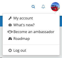
@iain-cochrane-0 As far as I know, there is no Settings menu on the MRA RoutePlanner website. Perhaps you're talking about the Toolkit menu that can be found near the top right of the screen, when editing a route?
Or maybe the "My Account" page that can be accessed from the menu that appears when clicking on your profile picture in the far top right of the screen.
-
Thanks for the quick reply.
What I am trying to do is switch on the "skip waypoint" option. I've attached a screenshot from the support page.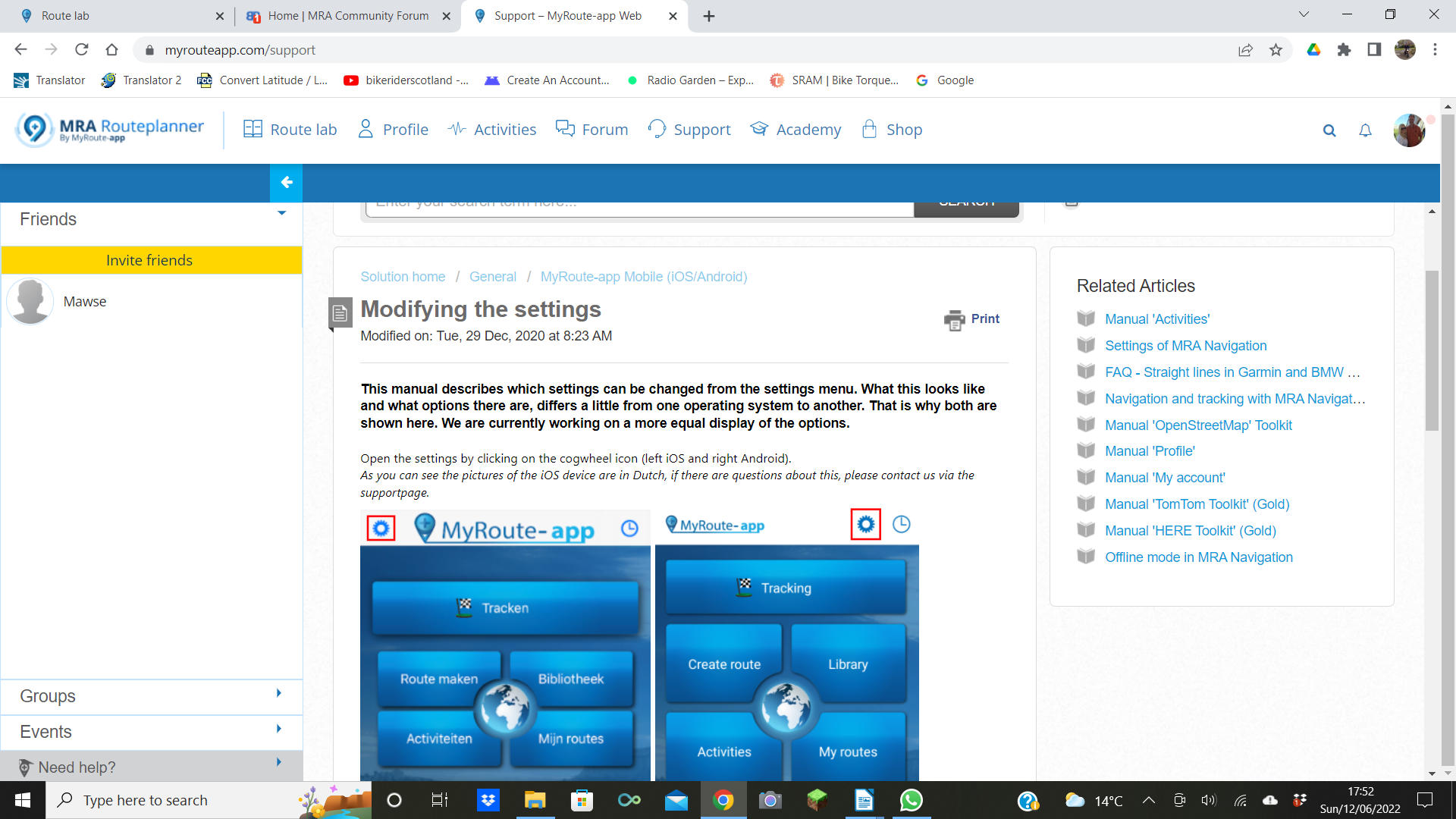
-
Hi, sorry for not being up to speed here, but could some kind person please show me how to access the "settings" menu ?
My main method of using MRA is on a pc.
This post is deleted! -
Thanks for the quick reply.
What I am trying to do is switch on the "skip waypoint" option. I've attached a screenshot from the support page.@iain-cochrane-0 That support article is about the MRA Mobile app, not the MRA Routeplanner website. The mobile app has been updated recently, but it doesn't look like that support article is already up-to-date with the new UI.
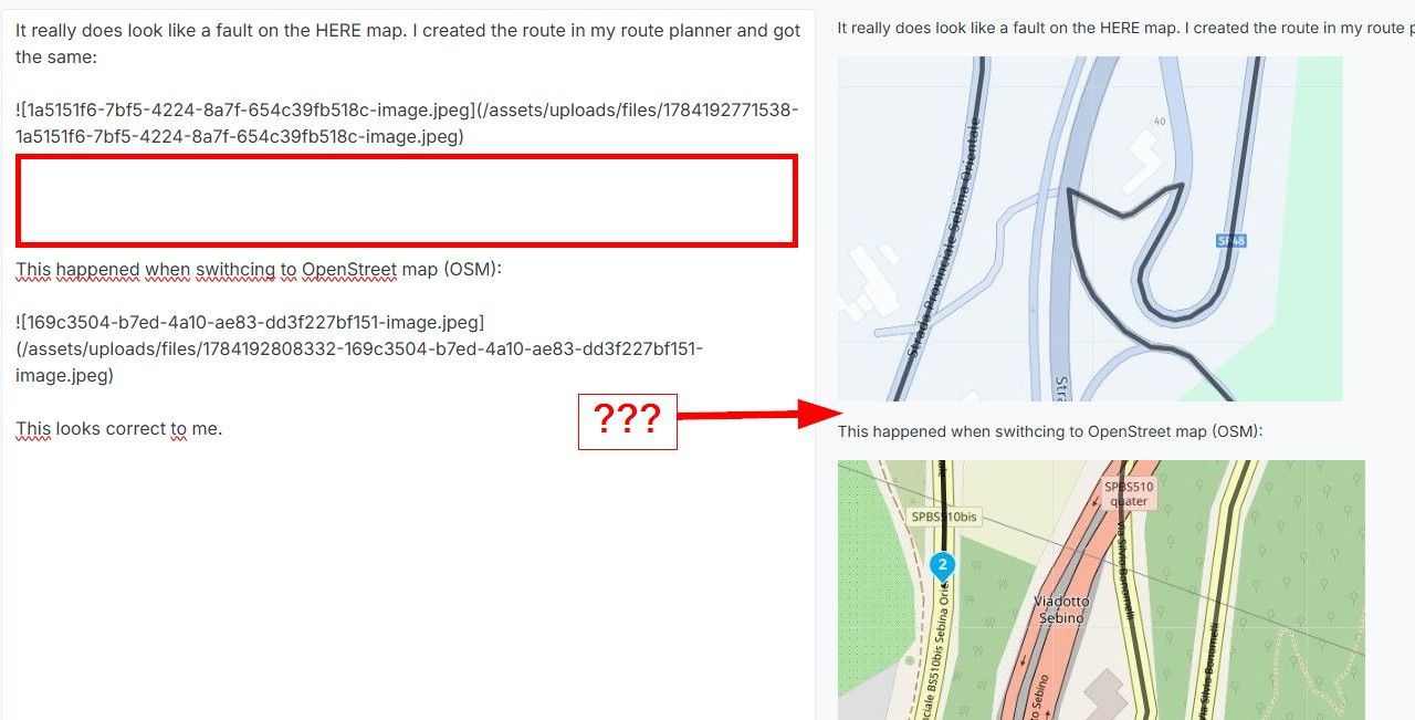
However, I don't think "skip waypoint" is in those settings. I think you're talking about the waypoint settings menu, that can be found by selecting a waypoint (at least in the MRA Routeplanner website). It looks like this:
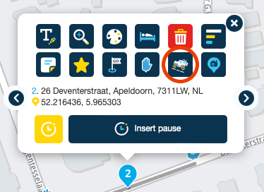
The support article for that functionality is here. More information about waypoints can be found here.
-
Thanks all for your input.
Maybe I should have just asked the question that was concerning me in the first place ?
We are just back from a week long tour in Belgium, and the issue I was having, (and so were others), is that when someone creates a route and then shares it to the rest of the group, it seems that if you miss a waypoint, for whatever reason, MRA/Tom Tom tries to take you back to the missed waypoint, which just results in disaster. I want to set my device in such a way that if I miss a waypoint, it will just aim for the next one ?
Any thoughts much appreciated. -
@iain-cochrane-0 That support article is about the MRA Mobile app, not the MRA Routeplanner website. The mobile app has been updated recently, but it doesn't look like that support article is already up-to-date with the new UI.
However, I don't think "skip waypoint" is in those settings. I think you're talking about the waypoint settings menu, that can be found by selecting a waypoint (at least in the MRA Routeplanner website). It looks like this:
The support article for that functionality is here. More information about waypoints can be found here.
@herko-ter-horst thank you, I have just found that !
-
Thanks all for your input.
Maybe I should have just asked the question that was concerning me in the first place ?
We are just back from a week long tour in Belgium, and the issue I was having, (and so were others), is that when someone creates a route and then shares it to the rest of the group, it seems that if you miss a waypoint, for whatever reason, MRA/Tom Tom tries to take you back to the missed waypoint, which just results in disaster. I want to set my device in such a way that if I miss a waypoint, it will just aim for the next one ?
Any thoughts much appreciated.@iain-cochrane-0 Forget what I said, that "skip waypoint" function is not what you are looking for.
Unless you are using the MRA Navigation app, which is not the same as the Mobile app or the Routeplanner website, it's not MRA that's doing that, as you have left the planning stage and are now wanting to navigate a pre-planned route using your navigation device or app of choice, so you'll need to look into the functionality of the device (or app) that you are using to navigate.
If you are using TomTom, I would recommend driving using a track instead of using a "route" with waypoints, if at all possible. Older TomTom's (that need to use .itn files) can't do that, but more recent ones can. If your TomTom uses TomTom MyDrive, you can save the track directly to it from the MRA Routeplanner (or the MRA Mobile app), by selecting "Save as" -> TomTom MyDrive.
-
@iain-cochrane-0 Forget what I said, that "skip waypoint" function is not what you are looking for.
Unless you are using the MRA Navigation app, which is not the same as the Mobile app or the Routeplanner website, it's not MRA that's doing that, as you have left the planning stage and are now wanting to navigate a pre-planned route using your navigation device or app of choice, so you'll need to look into the functionality of the device (or app) that you are using to navigate.
If you are using TomTom, I would recommend driving using a track instead of using a "route" with waypoints, if at all possible. Older TomTom's (that need to use .itn files) can't do that, but more recent ones can. If your TomTom uses TomTom MyDrive, you can save the track directly to it from the MRA Routeplanner (or the MRA Mobile app), by selecting "Save as" -> TomTom MyDrive.
@herko-ter-horst, thank you, I will try that out tomorrow !
-
@iain-cochrane-0 Forget what I said, that "skip waypoint" function is not what you are looking for.
Unless you are using the MRA Navigation app, which is not the same as the Mobile app or the Routeplanner website, it's not MRA that's doing that, as you have left the planning stage and are now wanting to navigate a pre-planned route using your navigation device or app of choice, so you'll need to look into the functionality of the device (or app) that you are using to navigate.
If you are using TomTom, I would recommend driving using a track instead of using a "route" with waypoints, if at all possible. Older TomTom's (that need to use .itn files) can't do that, but more recent ones can. If your TomTom uses TomTom MyDrive, you can save the track directly to it from the MRA Routeplanner (or the MRA Mobile app), by selecting "Save as" -> TomTom MyDrive.
@herko-ter-horst, hi again. I have been experimenting with what you suggested, and pleased to say working well.
My device is a Tom Tom 500, so no real problems importing the track.
Can I just ask, if I deviate from the track, for whatever reason, will it pick it back up again, or will I need to start over ? -
@herko-ter-horst, hi again. I have been experimenting with what you suggested, and pleased to say working well.
My device is a Tom Tom 500, so no real problems importing the track.
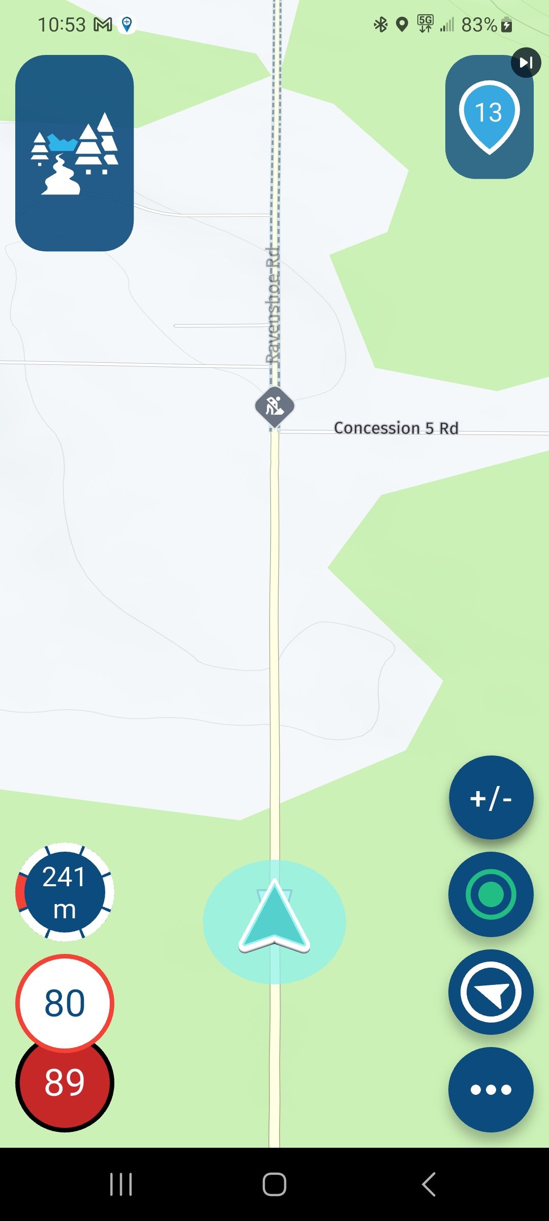
Can I just ask, if I deviate from the track, for whatever reason, will it pick it back up again, or will I need to start over ?@iain-cochrane-0 The TomTom will route you back to the track if you use .gpx. If however you are using .itn files in your TT and you miss a stop (their term for a route point) you can select Menu - Current route - Skip next stop. Otherwise your TT will keep sending you back ride past the missed stop.
Always willing to help if I can.
Triumph Tiger 1200 XRT called Tina.
MRA Navigation Next and SilverFox BJ8 -
@iain-cochrane-0 The TomTom will route you back to the track if you use .gpx. If however you are using .itn files in your TT and you miss a stop (their term for a route point) you can select Menu - Current route - Skip next stop. Otherwise your TT will keep sending you back ride past the missed stop.
@nick-carthew thanks for that. I'm using a Tom Tom 500.
I have the route that I was given, take it into MRA, save as Tom Tom to My Drive and then wirelessly connect to the device.
We will be doing some more routes soon, so keen to try this out. -
@nick-carthew thanks for that. I'm using a Tom Tom 500.
I have the route that I was given, take it into MRA, save as Tom Tom to My Drive and then wirelessly connect to the device.
We will be doing some more routes soon, so keen to try this out.@iain-cochrane-0 said in Settings menu:
@nick-carthew thanks for that. I'm using a Tom Tom 500.
I have the route that I was given, take it into MRA, save as Tom Tom to My Drive and then wirelessly connect to the device.
We will be doing some more routes soon, so keen to try this out.@Iain-Cochrane-0 Yes, it couldn't be easier. That's why I prefer TomTom over Garmin, they are so simple to use. Ok, the Garmin XT has a few more features and from what I hear, a brighter screen but I have never found my TT 500 screen to be too dark and I don't particularly care about what altitude I'm flying at

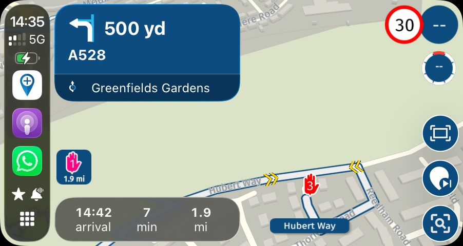
Some TT users prefer to use an .itn route instead of the .gpx track. With an .itn route as well as seeing your route points (stops) you have several options that are available via the TT500 menu once you have loaded the route. By the way, an .itn route can be recognised in your TTs My Routes library as it will have the number 2 in brackets (2) after it's name. So once your .itn route is loaded, select menu and then current route and the options are:-
Skip next stop (for skipping missed route points)
-
Find Alternative (this lets the TT500 find alternative routes, normally 3 and you choose which one you prefer)
-
Avoid Blocked Road (this is only active if TT knows of a blocked road on the route)
-
Avoid Road Types (choose to avoid motorways, toll roads, ferries and unpaved roads)
-
Avoid Part of Route (this gives a list of road names if you wish to avoid any on the route)
-
Show Instructions (turn by turn instructions with road names and distances)
-
Add Stop to Route (option to add a new route point)
-
Change Route Type ( fastest, shortest etc etc)
-
Reorder Stops (switch the order of individual route points)
Adding an .itn to your TT is a little more involved and requires connecting your TT to your PC/Mac with it's USB cable. In MRA choose save as and then choose .itn, this saves the file to your PC/Mac and then you can drag and drop your .itn route to the root folder of your TT500.
My preference is to use .gpx but occasionally, if I want to see the route points (stops) I'll use .itn.
Good luck
Always willing to help if I can.
Triumph Tiger 1200 XRT called Tina.
MRA Navigation Next and SilverFox BJ8 -
-
@iain-cochrane-0 said in Settings menu:
@nick-carthew thanks for that. I'm using a Tom Tom 500.
I have the route that I was given, take it into MRA, save as Tom Tom to My Drive and then wirelessly connect to the device.
We will be doing some more routes soon, so keen to try this out.@Iain-Cochrane-0 Yes, it couldn't be easier. That's why I prefer TomTom over Garmin, they are so simple to use. Ok, the Garmin XT has a few more features and from what I hear, a brighter screen but I have never found my TT 500 screen to be too dark and I don't particularly care about what altitude I'm flying at
Some TT users prefer to use an .itn route instead of the .gpx track. With an .itn route as well as seeing your route points (stops) you have several options that are available via the TT500 menu once you have loaded the route. By the way, an .itn route can be recognised in your TTs My Routes library as it will have the number 2 in brackets (2) after it's name. So once your .itn route is loaded, select menu and then current route and the options are:-
Skip next stop (for skipping missed route points)
-
Find Alternative (this lets the TT500 find alternative routes, normally 3 and you choose which one you prefer)
-
Avoid Blocked Road (this is only active if TT knows of a blocked road on the route)
-
Avoid Road Types (choose to avoid motorways, toll roads, ferries and unpaved roads)
-
Avoid Part of Route (this gives a list of road names if you wish to avoid any on the route)
-
Show Instructions (turn by turn instructions with road names and distances)
-
Add Stop to Route (option to add a new route point)
-
Change Route Type ( fastest, shortest etc etc)
-
Reorder Stops (switch the order of individual route points)
Adding an .itn to your TT is a little more involved and requires connecting your TT to your PC/Mac with it's USB cable. In MRA choose save as and then choose .itn, this saves the file to your PC/Mac and then you can drag and drop your .itn route to the root folder of your TT500.
My preference is to use .gpx but occasionally, if I want to see the route points (stops) I'll use .itn.
Good luck
@nick-carthew Hi Nick, thanks for all your info.
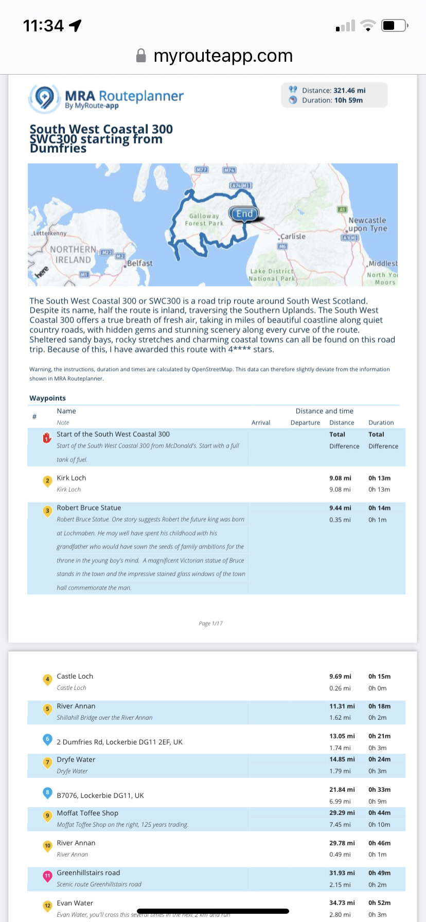
Purely by coincidence, last night I stumbled across one of your shared routes, viz, The South West Coastal 300, very appropriate, as this is my local area !
A huge amount of info on this route in the form of fuel, cafes, views, POIs etc.
If I decide to use this route with a bunch of friends who don't know the area, I'm assuming better a .itn file, rather than a gpx/track, in which case all this information would be lost,
Is that the case ?
Cheers, -
-
@nick-carthew Hi Nick, thanks for all your info.
Purely by coincidence, last night I stumbled across one of your shared routes, viz, The South West Coastal 300, very appropriate, as this is my local area !
A huge amount of info on this route in the form of fuel, cafes, views, POIs etc.
If I decide to use this route with a bunch of friends who don't know the area, I'm assuming better a .itn file, rather than a gpx/track, in which case all this information would be lost,
Is that the case ?
Cheers,@iain-cochrane-0 Unfortunately, TomTom will only show you the route points when you use an .itn file. You can of course add the POIs to your device by saving the .ov2 files. All of the information contained in the route point notes along with the colours used can be seen when using MRA Navigation. You could save and print a .pdf of the route for your tank bag as this contains the info too.
-
Interesting, thanks Nick.
Hello! It looks like you're interested in this conversation, but you don't have an account yet.
Getting fed up of having to scroll through the same posts each visit? When you register for an account, you'll always come back to exactly where you were before, and choose to be notified of new replies (either via email, or push notification). You'll also be able to save bookmarks and upvote posts to show your appreciation to other community members.
With your input, this post could be even better 💗
Register Login-
0371.0k
-
016314
-
0536
-
010298
-
06203
-
03101
-
0287.7k
-
0557