Off road turns into endless "proceed to XXX"
-
@Greenham I think it might be helpful to make your route public and share a link here. Certainly, I find it difficult to make any suggestions. Just one question, concerning your sat nav, and this only for clarity really... I believe (but could be wrong) that the 396 is compatible with .gpx 1.1 files. Is that what you used to transfer from MRA to the device?
@PAD-0 That is correct. I use the gpx 1.1 on exporting. Below is the link. The problem occurs between point 7 - 9. I rode the route again today. Same problem. When I opened the (proceed to Hwy 96) direction on the screen, It first said it 5,000 miles, then it cleared and the rest of the route proceeded perfectly..
https://www.myrouteapp.com/en/social/route/2496687?mode=share
"There is no problem so bad that you can't make it worse"
- Chris Hadfield (NASA Astronaut)
-
@PAD-0 That is correct. I use the gpx 1.1 on exporting. Below is the link. The problem occurs between point 7 - 9. I rode the route again today. Same problem. When I opened the (proceed to Hwy 96) direction on the screen, It first said it 5,000 miles, then it cleared and the rest of the route proceeded perfectly..
https://www.myrouteapp.com/en/social/route/2496687?mode=share
@Greenham The only thing I noticed on a cursory glance is that WP8 & WP9 aren’t well located on the road centre line. Looking at street view, this isn’t a wide road and the location doesn’t seem absurdly wide, but nonetheless I‘d be inclined to go through the route, zoom in as far as possible on every waypoint and centre every one exactly on that centre line.
-
Hi Greenham,
Which file do you use in your Zumo? The route or the Track?
For the older Zumo models, it is best to use the Track.
Go to tracks, click on the track of the route you want to drive, then click on the key in the upper left corner.
Choose to make visible,
Choose a color (black or white for the best contrast)
Choose, convert to travel
Choose from start to finish
Zumo is going to count ......
When he has finished calculating, you go to the travel planner and the calculated route based on your Track is included in your travels.
Turn the recalculation OFF!
You now have only 2 Hard Route Points, namely start and finish.
If you deviate from the route, you must drive back to the route in sight (Track has made you visible)With the XT you can use the route.
Garmin Zumo XT3/XT2/XT/BMW Connected Ride Navigator/Tourstart/ MyRouteapp (The App)/...
Een dag niet gelachen is een dag niet geleefd / Een route is net zo goed als deze uitgezet is. -
Hi Greenham,
Which file do you use in your Zumo? The route or the Track?
For the older Zumo models, it is best to use the Track.
Go to tracks, click on the track of the route you want to drive, then click on the key in the upper left corner.
Choose to make visible,
Choose a color (black or white for the best contrast)
Choose, convert to travel
Choose from start to finish
Zumo is going to count ......
When he has finished calculating, you go to the travel planner and the calculated route based on your Track is included in your travels.
Turn the recalculation OFF!
You now have only 2 Hard Route Points, namely start and finish.
If you deviate from the route, you must drive back to the route in sight (Track has made you visible)With the XT you can use the route.
@Hans-van-de-Ven-MRA-Master THanks Hans, Yes I use your documented process as you outlined in your comment.
I will take Pad-O advice and check the placement of my shaping points.
I did just buy the XT... what would e different with it when exporting from MRA tothe XT?
"There is no problem so bad that you can't make it worse"
- Chris Hadfield (NASA Astronaut)
-
@Hans-van-de-Ven-MRA-Master THanks Hans, Yes I use your documented process as you outlined in your comment.
I will take Pad-O advice and check the placement of my shaping points.
I did just buy the XT... what would e different with it when exporting from MRA tothe XT?
My personal choice for the XT is to transfer the Beta Zumo XT GPX1.1 using the Garmin Drive App. I generally use an iPad Pro for this.
This creates the route automatically in the Trip Planner App on the XT.
I only use Shaping Points and I make a point of adding at least 1 shaping point on every road I want to travel on regardless of how long the route is.This works for me, it has never recalculated on me and when I get a road closure it will prompt a couple of U-Turns which I ignore and it will automatically find its way back to the shaping points I plotted in MRA.
I don’t find that I need any track visible to get me back on my route.
When I do go off road, UK Green Lanes (Byways Open to All Traffic) then tracks are perfect.
I plot them in the OS Maps App and transfer directly to the Garmin via a PC.
You do not get any notifications or turns you simply follow the Track visually.
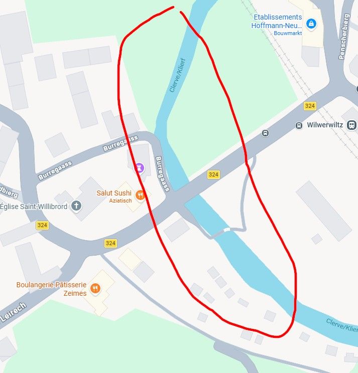
Below is Salisbury Plains with 74 individual Green Lanes placed in a Collection to make them all visible on the map at once.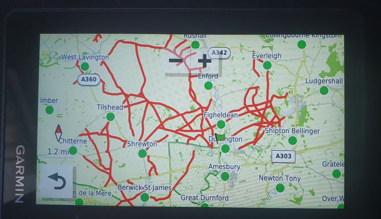
-
@Hans-van-de-Ven-MRA-Master THanks Hans, Yes I use your documented process as you outlined in your comment.
I will take Pad-O advice and check the placement of my shaping points.
I did just buy the XT... what would e different with it when exporting from MRA tothe XT?
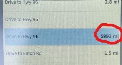
@Greenham I reran the route today and stopped to take the pics as each stage of the malfunction. 1) Said Leave the Road. 2) Ride to Hwy 96. 3) When I opened that message you can see the GPS thinks the next shaping point is 5500 miles away
 image url)
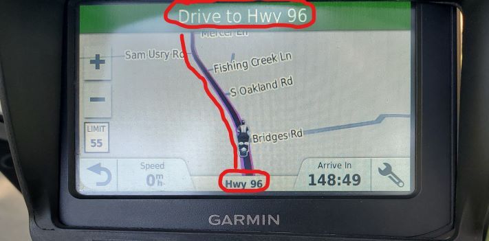
-
@Hans-van-de-Ven-MRA-Master THanks Hans, Yes I use your documented process as you outlined in your comment.
I will take Pad-O advice and check the placement of my shaping points.
I did just buy the XT... what would e different with it when exporting from MRA tothe XT?
That you can use the created route, with via-points
-
I don't understand the quite frequently repeated recommendation for older Garmin devices that a track be used. I have never done so, having only exported routes into my Zumo 390. Every one has worked perfectly well. Using a track on the road seems a very limiting approach to me.
In the case of my 390, I choose the 'old Garmin' .gpx file, however the 396 is still a current model in Garmin's motorcycle line up and I believe it supports .gpx 1.1 files.
Can someone enlighten me as to why this 'track recommendation' exists, please?
With the older zumos, you get a so-called "Direct route" in your system, which you have to let the system recalculate, and so can deviate from your planned route
Garmin Zumo XT3/XT2/XT/BMW Connected Ride Navigator/Tourstart/ MyRouteapp (The App)/...
Een dag niet gelachen is een dag niet geleefd / Een route is net zo goed als deze uitgezet is. -
With the older zumos, you get a so-called "Direct route" in your system, which you have to let the system recalculate, and so can deviate from your planned route
@Hans-van-de-Ven-MRA-Master That hasn’t been my experience at all, but maybe I just manage to put in all the right waypoints in all the right places or something (so more Andrew Preview than Eric Morcambe🤪)?
Only if I use a .gpx 1.1 file do I get straight lines - can I take it that is what is meant by ‘direct route’? I do appreciate that, in such circumstances, where recalculation is required to make lines follow roads, deviation from the intended route is highly likely. Using .gpx 1.0… perfect routes on the 390 every time. I used such a route today, in fact, running concurrently with Navigation (Zūmo bluetooth off to avoid two sets of voice instructions!). Identical renditions.
Hello! It looks like you're interested in this conversation, but you don't have an account yet.
Getting fed up of having to scroll through the same posts each visit? When you register for an account, you'll always come back to exactly where you were before, and choose to be notified of new replies (either via email, or push notification). You'll also be able to save bookmarks and upvote posts to show your appreciation to other community members.
With your input, this post could be even better 💗
Register Login-
021353
-
0352
-
114369
-
0487
-
726288
-
0228
-
3171.6k
-
05175