Skip to content
  • Categories
  • Recent
  • Popular
  • Support
  • MyRoute-app
Collapse
Brand Logo

MRA Community Forum

  1. Home
  2. MyRoute-app Routeplanner
  3. [Web] Problems, Bugs and other Issues
  4. POI import anomalies

POI import anomalies

Scheduled Pinned Locked Moved [Web] Problems, Bugs and other Issues
4 Posts 2 Posters 647 Views 2 Watching
  • Oldest to Newest
  • Newest to Oldest
  • Most Votes
Reply
  • Reply as topic
Log in to reply
This topic has been deleted. Only users with topic management privileges can see it.
  • David Steinerundefined Offline
    David Steinerundefined Offline
    David Steiner
    wrote on last edited by
    #1

    I am trying to import POI groups into the Route Planner. In this particular case a list of all the covered bridges in my state (New Hampshire). This is a subset of a CSV of all covered bridges in the US. To do this, I used the following methodology:

    • found the lat/long for the corners of a bounding box that covered the state. This covers a bit of surrounding states but I figured that I could edit outliers after seeing them plotted.
    • sorted the master file by lat and long, and removed any entries outside the bounding box
    • imported the resulting file to the Route Planner.

    This seemed to work as expected but upon closer inspection, I found a couple of strange things:

    • there are 5 POIs shown that are outside the bounding box that I can not find if I search in the CSV. None of these are actually bridges (four of them are waterfalls).
    • When I look in the CSV, I see at least one bridge that is outside NH (I recognize the name) but I think is inside the bounding box however it does not show as a POI in the Route Planner.

    Can anyone give me a clue as to why this may be happening?
    Thanks.

    1 Reply Last reply
    0
    • Mzokkundefined Offline
      Mzokkundefined Offline
      Mzokk
      wrote on last edited by
      #2

      Oddly to import a CSV POI list into MRA you need to organise the list by Long,Lat,and Name. This is a CSV of Irish photorally waypoints I have imported to my library.
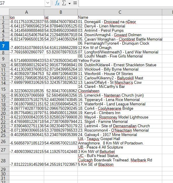
      dff74ed2-f1f6-4e54-85e1-42bd4650abae-image.jpeg

      To get to this point I had to merge several columns of data into the "Name" column so that when you clicked on the waypoint on the map you got some meaningful indication of what the point was. When I imported the same info as a GPX all I got was the Long and Lat which wasn't very helpful. Its an aspect of the MyRoute app route planner that is ripe for improvement.

      1 Reply Last reply
      0
      • David Steinerundefined Offline
        David Steinerundefined Offline
        David Steiner
        wrote on last edited by
        #3

        First, thanks @mzokk. Despite that the fact that I said "lat/long" in the post, the columns were as you pointed out, "long/lat, in the file.
        Second, seems I managed to be "that guy" who manages to, on his first post to the list, waste space and time with a bogus question. I posted after the 3rd time looking things over and not seeing it, only to find, 10 minutes later on my fourth look, that I had uploaded a different file than I intended and was searching for the points in the wrong place. 😞
        I removed that import and imported the right file and, lo and behold, everything was as it should be.
        My apologies to the group and anyone whose time I wasted. I will try to do better the next time I post.
        Thanks.
        -David-

        1 Reply Last reply
        1
        • Mzokkundefined Offline
          Mzokkundefined Offline
          Mzokk
          wrote on last edited by
          #4

          No problem.......I introduced myself here..........twice my only excuse is I'm 65 soon 😁

          1 Reply Last reply
          0

          Hello! It looks like you're interested in this conversation, but you don't have an account yet.

          Getting fed up of having to scroll through the same posts each visit? When you register for an account, you'll always come back to exactly where you were before, and choose to be notified of new replies (either via email, or push notification). You'll also be able to save bookmarks and upvote posts to show your appreciation to other community members.

          With your input, this post could be even better 💗

          Register Login
          Reply
          • Reply as topic
          Log in to reply
          • Oldest to Newest
          • Newest to Oldest
          • Most Votes


          ACTIVE USERS
          Mzokkundefined
          Mzokk
          David Steinerundefined
          David Steiner
          POPULAR TOPICS
          • Many problems navigating my route
            Leike Lodiersundefined
            Leike Lodiers
            0
            8
            88

          • v5.2 (473) Feedback
            Con Hennekensundefined
            Con Hennekens
            0
            9
            213

          • Reading out the name of the waypoint and associated notes
            Lenny Oundefined
            Lenny O
            0
            43
            1.2k

          • Geen extra ruimte tussen zinnen mogelijk?
            Corjan Meijerinkundefined
            Corjan Meijerink
            0
            10
            311

          • Was er een storing op de server?
            nomkoundefined
            nomko
            0
            3
            59

          • Unknown symbol
            Leike Lodiersundefined
            Leike Lodiers
            0
            7
            245

          • Permanent afgesloten wegen voor motorrijders
            Leike Lodiersundefined
            Leike Lodiers
            0
            29
            7.8k

          • Importeren afsluitingen in MRA
            Leike Lodiersundefined
            Leike Lodiers
            0
            2
            45

          MY GROUPS
          • Login

          • Login or register to search.
          • First post
            Last post
          0
          • Categories
          • Recent
          • Popular
          • Support
          • MyRoute-app