Option to Route through Closed Roads
-
I posted on this some months back. HERE is notorious for not keeping road closure re-openings up to date. We also have roads in Southern California that are officially closed, but in reality, are open to motorcycles.
The point is that it would be incredibly convenient to have an option to allow routing through closed roads. Are there any plans to update Routeplanner for this option? I know that I can use OSM as the base map to get around this limitation. Or possibly the skip option using when using HERE. However, neither work around is convenient nor clean.
I'll leave it alone if it's not on the radar anytime soon.
@John-S-Parry Have you tried using the Disable seasonal closures tool?
Always willing to help if I can.
Triumph Tiger 1200 XRT called Tina.
MRA Navigation Next and SilverFox BJ8 -
@John-S-Parry Have you tried using the Disable seasonal closures tool?
@Nick-Carthew I didn't have Disable seasonal closures on, because it's not applicable to this situation. (See Google attached picture). It's a short section of road that suffered storm damage 2-years ago, but it is passable on a motorcycle. However, I just turned the tool on, and indeed, the route went through.
Thanks for the tip. I appreciate it. But it makes no sense to me why that works when it has nothing to with seasonal closures.
-
@Nick-Carthew I didn't have Disable seasonal closures on, because it's not applicable to this situation. (See Google attached picture). It's a short section of road that suffered storm damage 2-years ago, but it is passable on a motorcycle. However, I just turned the tool on, and indeed, the route went through.
Thanks for the tip. I appreciate it. But it makes no sense to me why that works when it has nothing to with seasonal closures.
@John-S-Parry It also works for some temporary closed roads that are not seasonal closures

Always willing to help if I can.
Triumph Tiger 1200 XRT called Tina.
MRA Navigation Next and SilverFox BJ8 -
@Nick-Carthew I didn't have Disable seasonal closures on, because it's not applicable to this situation. (See Google attached picture). It's a short section of road that suffered storm damage 2-years ago, but it is passable on a motorcycle. However, I just turned the tool on, and indeed, the route went through.
Thanks for the tip. I appreciate it. But it makes no sense to me why that works when it has nothing to with seasonal closures.
@John-S-Parry I think it is bit unrealistic to expect the map data suppliers to go to the level of a the road is closed for cars but okay for motorcycles
at what level would they stop differentiating, good for 2 wheel motorcycles but not a trike or sidecarthe seasonal closure trick works because it basically igonres "closures"
the only time it seemns not to work is if the road is totaly gone & the map data is updated to say the road is washed out / no longer existsBlackView BV7100, Android 12
Navigate "Routes as Tracks" in Offline mode with Offline Maps
No Wifi, no internet, no interruptions, works well -
@John-S-Parry I think it is bit unrealistic to expect the map data suppliers to go to the level of a the road is closed for cars but okay for motorcycles
at what level would they stop differentiating, good for 2 wheel motorcycles but not a trike or sidecarthe seasonal closure trick works because it basically igonres "closures"
the only time it seemns not to work is if the road is totaly gone & the map data is updated to say the road is washed out / no longer exists@Brian-McG it’s more about me telling the route planner that I want the option of all roads available for route creation, regardless of reason. The reality is that sometimes route developer has better information than the map vendors. I gave just one example.
I use also use an Apple based route planner (inRoute) that has an explicit option to ignore closed roads. So it’s not some strange outlier that lacks value to many. To be fair, Maybe Apple Maps has an API option that doesn’t exist within HERE. But it’s odd that Garmin Basecamp uses HERE, and doesn’t impose closed roads restrictions.
A seasonal closure has a specific meaning that doesn’t apply to the example I gave. Yes, it works in this instance, but I’m always
uncomfortable with options that don’t make complete sense. It gets down to a trust issue.Again, I understand I have a few options for workarounds. One is using the OSM base map instead of HERE. You suggested that to me previously. Thanks for that. The other is to use the waypoint Skip function to bypass the closed area. They both work, but in my mind they’re bandaids. However, it that what it takes in the absence of an available ignore option in the long term, so be it. I’m just checking in for clarification.
-
@John-S-Parry It also works for some temporary closed roads that are not seasonal closures
@Nick-Carthew said in Option to Route through Closed Roads:
@John-S-Parry It also works for some temporary closed roads that are not seasonal closures
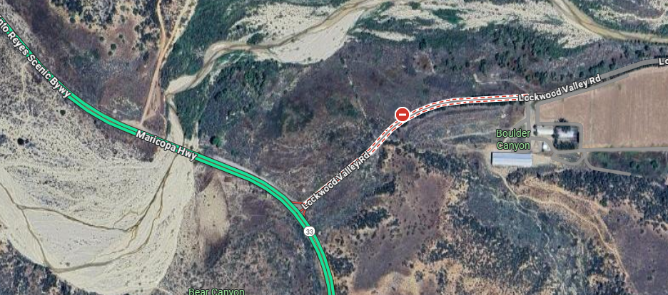
Nick, attached is another temporary road closure in my area. As you can see, the seasonal closure option doesn't bridge the closed section between points 10 and 11:
I'm presenting this to point out that the seasonal closure "trick" is hit-and-miss and can't be depended on in all instances. Therefore, for me, it's a no go. Again, the waypoint Skip function or use of the OSM base map are features that will always work, and I'll use them in the appropriate situations. Thankfully, when I import the MRA created GPX into my Zumo XT, the route will recalculate correctly.
I understand that the limitations in HERE maps are a sore spot within the MRA community. But I love Routeplanner and I'm will to live with HERE map warts that are beyond annoying sometimes. In the interest of advancing MRA know how, it's all good to acknowledge shortcomings and have honest conversations about what can (and can't) be done. I've learned a lot by poking these issues.
-
@Nick-Carthew said in Option to Route through Closed Roads:
@John-S-Parry It also works for some temporary closed roads that are not seasonal closures
Nick, attached is another temporary road closure in my area. As you can see, the seasonal closure option doesn't bridge the closed section between points 10 and 11:
I'm presenting this to point out that the seasonal closure "trick" is hit-and-miss and can't be depended on in all instances. Therefore, for me, it's a no go. Again, the waypoint Skip function or use of the OSM base map are features that will always work, and I'll use them in the appropriate situations. Thankfully, when I import the MRA created GPX into my Zumo XT, the route will recalculate correctly.
I understand that the limitations in HERE maps are a sore spot within the MRA community. But I love Routeplanner and I'm will to live with HERE map warts that are beyond annoying sometimes. In the interest of advancing MRA know how, it's all good to acknowledge shortcomings and have honest conversations about what can (and can't) be done. I've learned a lot by poking these issues.
@John-S-Parry This is why I said it works on some temporary road closures.
-
@Nick-Carthew said in Option to Route through Closed Roads:
@John-S-Parry It also works for some temporary closed roads that are not seasonal closures
Nick, attached is another temporary road closure in my area. As you can see, the seasonal closure option doesn't bridge the closed section between points 10 and 11:
I'm presenting this to point out that the seasonal closure "trick" is hit-and-miss and can't be depended on in all instances. Therefore, for me, it's a no go. Again, the waypoint Skip function or use of the OSM base map are features that will always work, and I'll use them in the appropriate situations. Thankfully, when I import the MRA created GPX into my Zumo XT, the route will recalculate correctly.
I understand that the limitations in HERE maps are a sore spot within the MRA community. But I love Routeplanner and I'm will to live with HERE map warts that are beyond annoying sometimes. In the interest of advancing MRA know how, it's all good to acknowledge shortcomings and have honest conversations about what can (and can't) be done. I've learned a lot by poking these issues.
@John-S-Parry your example between 10 & 11 is exactly the what I was referring to as washed out/no longer exists
I would not expect the season closure trick to work there because the Here map data shows it as no viable road / no longer being a passable road as it is depicted as under constructionBlackView BV7100, Android 12
Navigate "Routes as Tracks" in Offline mode with Offline Maps
No Wifi, no internet, no interruptions, works well -
@John-S-Parry your example between 10 & 11 is exactly the what I was referring to as washed out/no longer exists
I would not expect the season closure trick to work there because the Here map data shows it as no viable road / no longer being a passable road as it is depicted as under construction@Brian-McG I think my topic has gotten a little off track. I'm asking if there is anything on the horizon to add a "Ignore Closed Roads" option. There are specific situations where I, the route creator, have better/more accurate information than HERE as far as specific road situations. I don't want to be prevented by MRA/HERE from creating a route in an area that I KNOW is currently passible. Or I know that it will be passible very soon -- much sooner than HERE can make the update for MRA to incorporate. I already understand the "tricks" I can use to get around HERE limitations. I'm specifically asking about an option that allows me to proceed without trying to play games with Routeplanner.
As far as my example between 10 & 11, it's a legitimate closure for emergency repairs. I know the segment well, especially having ridden it a few times during the month of October. It certainly exists, it's viable, and I'd be surprised if it's not fixed in the next few days. Hwy 2 is a vital artery between Los Angeles and the Desert. Regardless, this is actually a case where MRA/HERE is providing correct information.
I suspect an "Ignore Closed Roads" option isn't on the drawing board now or in the future. Especially since using the OSM Map or the Skip option are proven workarounds. What I've learned here is the seasonal closure trick is iffy and something I wouldn't trust as an on-going strategy. There is always something to learn.

-
@Brian-McG I think my topic has gotten a little off track. I'm asking if there is anything on the horizon to add a "Ignore Closed Roads" option. There are specific situations where I, the route creator, have better/more accurate information than HERE as far as specific road situations. I don't want to be prevented by MRA/HERE from creating a route in an area that I KNOW is currently passible. Or I know that it will be passible very soon -- much sooner than HERE can make the update for MRA to incorporate. I already understand the "tricks" I can use to get around HERE limitations. I'm specifically asking about an option that allows me to proceed without trying to play games with Routeplanner.
As far as my example between 10 & 11, it's a legitimate closure for emergency repairs. I know the segment well, especially having ridden it a few times during the month of October. It certainly exists, it's viable, and I'd be surprised if it's not fixed in the next few days. Hwy 2 is a vital artery between Los Angeles and the Desert. Regardless, this is actually a case where MRA/HERE is providing correct information.
I suspect an "Ignore Closed Roads" option isn't on the drawing board now or in the future. Especially since using the OSM Map or the Skip option are proven workarounds. What I've learned here is the seasonal closure trick is iffy and something I wouldn't trust as an on-going strategy. There is always something to learn.
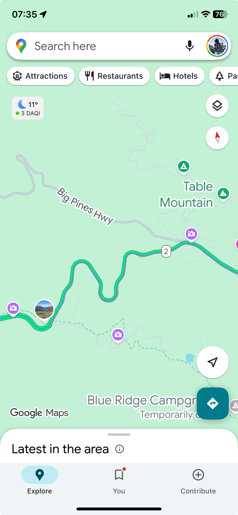
@John-S-Parry Interesting that Google Maps with their traffic overlay on doesn’t show a road closure between 10 and 11.
Always willing to help if I can.
Triumph Tiger 1200 XRT called Tina.
MRA Navigation Next and SilverFox BJ8 -
@John-S-Parry Interesting that Google Maps with their traffic overlay on doesn’t show a road closure between 10 and 11.
@Nick-Carthew Yes, I found that curious too. I consider Google Maps the gold standard for identifying traffic/closures and couldn't find it either. I dug a little deeper and found the following on the California Department of Transportation (CALTRANS) road status website:
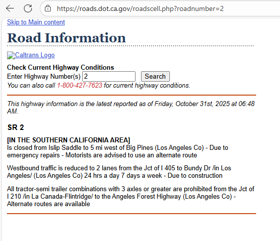
I called their number too.
The closure is real with and undetermined time for reopening, but I suspect it will be soon.I'm glad this came up because it illustrates the checklist I go through in investigating/developing a route. I start with checks on Google/Apple Maps for any real-time closures. For any critical roads in rural area, I'll proceed to Government Road information sites like Caltrans as a deeper check. That's why I'm not a big fan of any routing program I use (MRA, Basecamp, inRoute, OsmAnd) restricting me from developing a route in areas where I do my own research. Even though Google (from my experience) is the best, it's not perfect, as you can see above. And frankly I've found HERE to be the worst. I can show examples of closed roads that HERE says are open, and open roads that HERE says are closed. That's why I'm a big believer in having an "Ignore Closed Roads" option in Routeplanner, to let me decide what's open and not. I don't need big brother directing me.
Hello! It looks like you're interested in this conversation, but you don't have an account yet.
Getting fed up of having to scroll through the same posts each visit? When you register for an account, you'll always come back to exactly where you were before, and choose to be notified of new replies (either via email, or push notification). You'll also be able to save bookmarks and upvote posts to show your appreciation to other community members.
With your input, this post could be even better 💗
Register Login-
71277.7k
-
112385
-
1555
-
029697
-
0292.0k
-
010449
-
0290
