making more than 1 track visible in same view
-
Ich hoffe ich habe deine Frage richtig verstanden. Anzeigen kann du ganz viele Routen auf einmal. Im Planungsmodus, klickst du links auf Routen (unterhalb von Favoriten). Dann auf Hinzufügen und wählt damit die Routen aus deinem Verzeichnis aus, die du Anzeigen möchtest.
Man kann dann noch die Farbe ändern.
Jetzt kann man diese angezeigten Routen, mit Klick auf das Plus Symbol der ursprünglichen Route (oder wenn die Seite leer war) am Anfang oder Ende hinzufügen.
Ein exportieren der Angezeigten Routen geht aber im Anzeige Modus nicht.Hardware
iPhone 12 pro (iOS 26.2.1)
iPad (7.Gen.) 18.7.3
Oukitel RT3 Pro (Andr. 14)
Wireless CarPlay mit (Elebest C650)
Wired CarPlay (SEAT Arona - 2021)
MRA Workshops in Deutsch sind hier zu finden -
Ich hoffe ich habe deine Frage richtig verstanden. Anzeigen kann du ganz viele Routen auf einmal. Im Planungsmodus, klickst du links auf Routen (unterhalb von Favoriten). Dann auf Hinzufügen und wählt damit die Routen aus deinem Verzeichnis aus, die du Anzeigen möchtest.
Man kann dann noch die Farbe ändern.
Jetzt kann man diese angezeigten Routen, mit Klick auf das Plus Symbol der ursprünglichen Route (oder wenn die Seite leer war) am Anfang oder Ende hinzufügen.
Ein exportieren der Angezeigten Routen geht aber im Anzeige Modus nicht.@Jörgen Hi Jörgen, hab mir schon gedacht, daß du antwortest; wollte dich aber nicht direkt ansprechen, damit die anderen User auch etwas davon haben.
Was du geantwortet hast, ist mir alles geläufig.
Es liegt wohl an der grundsätzlichen Ausrichtung von MyRoute-App - die im Gegensatz zu MRA-Routeplanner - leider nicht darauf abzielt, einen Track aus einer GPX-Datei einfach darzustellen. Und den aktuellen Standort einzublenden. Die App will unbedingt navigieren - mit Icons und Ansagen.
Wenn ich mir die GPX-Datei ansehen, dann sind da einfach nur mehrere <trk> Abschnitte drin. Beim Import in MRA-Routeplanner, werden aber automatisch entsprechend einzelne Routendateien erzeugt. Damit beginnt die Sackgasse der Entwicklung.
Und in MyRoute-App kann man eine GPX-Datei (noch?) gar nicht direkt importieren; nicht einmal, wenn man den Routenplaner der App nutzt.Andere Apps, die ich nannte, können sehr wohl einen Track einfach nur anzeigen und den aktuellen Standort darüber einblenden. Sie können sogar mehrere Tracks gleichzeitig anzeigen, die ggf. in nur einer Datei enthalten sind. Ist ja auch keine Raketenwissenschaft, da nicht navigiert wird. Das macht der (Offroad-)Fahrer selbst.

............................
Hi Jörgen, I thought you would reply, but I didn't want to address you directly so that the other users could benefit from it.I'm familiar with everything you answered.
It is probably due to the basic orientation of the MyRoute app - which, unlike MRA-Routeplanner, unfortunately does not aim to simply display a track from a GPX file. And to show the current location. The app really wants to navigate - with icons and announcements.
When I look at the GPX file, there are simply several <trk> sections in it. When importing into MRA-Routeplanner, however, individual route files are automatically generated. This is where the dead end of development begins.
And you can't (yet?) import a GPX file directly into MyRoute app; not even if you use the app's route planner.Other apps that I mentioned can simply display a track and show the current location above it. They can even display several tracks at the same time, which may be contained in just one file. It's not rocket science either, as there is no navigation. The (off-road) driver does that himself.
Nothing is impossible ;-)
In past: GARMIN Zumo 210->GARMIN Zumo 395->GARMIN XT=> now: DMD T865-X + MyRoute-App, LocusMaps, OsmAnd.
In past: GARMIN MapSource ->GARMIN BaseCamp->Tyre->Kurviger->Calimoto=> now: MRA-Routplanner. -
@Jörgen Hi Jörgen, hab mir schon gedacht, daß du antwortest; wollte dich aber nicht direkt ansprechen, damit die anderen User auch etwas davon haben.
Was du geantwortet hast, ist mir alles geläufig.
Es liegt wohl an der grundsätzlichen Ausrichtung von MyRoute-App - die im Gegensatz zu MRA-Routeplanner - leider nicht darauf abzielt, einen Track aus einer GPX-Datei einfach darzustellen. Und den aktuellen Standort einzublenden. Die App will unbedingt navigieren - mit Icons und Ansagen.
Wenn ich mir die GPX-Datei ansehen, dann sind da einfach nur mehrere <trk> Abschnitte drin. Beim Import in MRA-Routeplanner, werden aber automatisch entsprechend einzelne Routendateien erzeugt. Damit beginnt die Sackgasse der Entwicklung.
Und in MyRoute-App kann man eine GPX-Datei (noch?) gar nicht direkt importieren; nicht einmal, wenn man den Routenplaner der App nutzt.Andere Apps, die ich nannte, können sehr wohl einen Track einfach nur anzeigen und den aktuellen Standort darüber einblenden. Sie können sogar mehrere Tracks gleichzeitig anzeigen, die ggf. in nur einer Datei enthalten sind. Ist ja auch keine Raketenwissenschaft, da nicht navigiert wird. Das macht der (Offroad-)Fahrer selbst.
............................
Hi Jörgen, I thought you would reply, but I didn't want to address you directly so that the other users could benefit from it.I'm familiar with everything you answered.
It is probably due to the basic orientation of the MyRoute app - which, unlike MRA-Routeplanner, unfortunately does not aim to simply display a track from a GPX file. And to show the current location. The app really wants to navigate - with icons and announcements.
When I look at the GPX file, there are simply several <trk> sections in it. When importing into MRA-Routeplanner, however, individual route files are automatically generated. This is where the dead end of development begins.
And you can't (yet?) import a GPX file directly into MyRoute app; not even if you use the app's route planner.Other apps that I mentioned can simply display a track and show the current location above it. They can even display several tracks at the same time, which may be contained in just one file. It's not rocket science either, as there is no navigation. The (off-road) driver does that himself.
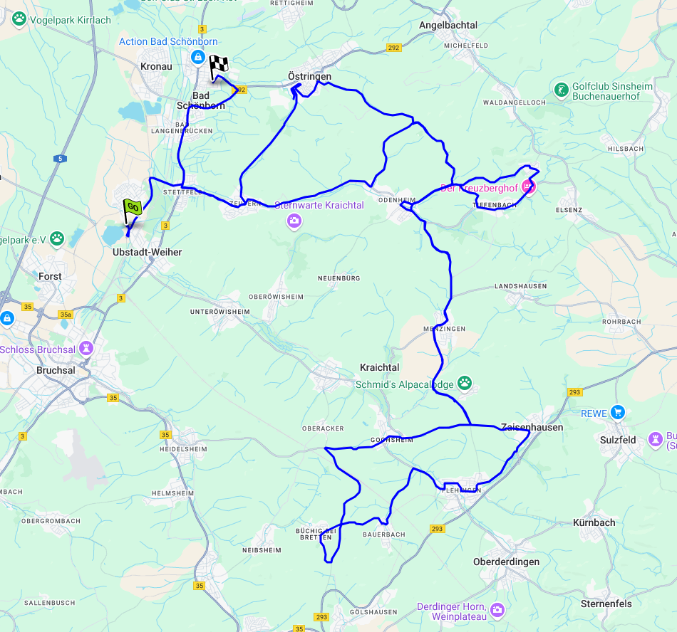
@Guzzist said in making more than 1 track visible in same view:
einen Track aus einer GPX-Datei einfach darzustellen.
Doch kann man, siehe hier: Importierter GPX Track (Beispiel Ironman Radstrecke Kraichgau)
@Guzzist said in making more than 1 track visible in same view:
Und den aktuellen Standort einzublenden
Meinst du das Ganze in der Navi-App? Sorry stehe da etwas auf dem Schlauch, was du eigentlich willst.
-
Danke für deinen Beitrag @Jörgen. Aber ich bin vertraut mit den Möglichkeiten in MyRoute-Planner, zu einer Route - als Ausgangsbasis - mehrere Tracks oder Routen dazu anzeigen zu lassen.
Nicht aber bei der Ausgangsbasis eines Tracks - da gibt es keinerlei Optionen irgend etwas dazu anzeigen zu lassen.
................
Thanks you for your contribution @Jörgen. But I'm familiar with options in MyRoute-Planner to display display several tracks or routes additionally - by beginning with a route.
But not for beginning with a track - there are no options to display anything at all.
Wenn man diese Route (mit zusätzlich angezeigten Tracks oder Routen) als GPX lokal speichern möchte, ist nur die Hauptroute enthalten.
Ja, ich weiß, damß man zusätzlich angezeigt Route mit der Hauptroute verbinden kann - dann werden die verbundenen Routen auch in der GPX abgespeichert.
............................
If you want to save this route (with additionally displayed tracks or routes) as a GPX locally, only the main route is included.
Yes, I know, so that you can connect additional displayed routes with the main route - then the connected routes are also saved in the GPX.Aber die Möglichkeit, sich zur Route eben zusätzliche Tracks oder Routen anzeigen zu lassen, gibt es nur in MyRoute-Planner.
Nicht aber in MyRoute-App:
.......................
But the option to display additional tracks or routes to a route is only available in MyRoute-Planner.
But not in the MyRoute app:
Beim Synchronisieren der Route von MRA-Routeplanner nach MyRoute-App wird nur die Haupt-Route übertragen. Und es gibt keinerlei Optionen irgend etwas dazu anzeigen zu lassen!
.........................
When synchronizing the route from MRA route planner to MyRoute app, only the main route is transferred. And there are no options to display anything in addition!Andere Apps können das aber - mehrere Tracks gleichzeitig anzeigen zu lassen. Sie werden zwar - auch wenn sie zusammen in einer GPX Datei enthalten waren, einzeln in der App abgelegt. Doch man kann dann immer wählen, welche man davon auf der Karte sehen will:
.........................
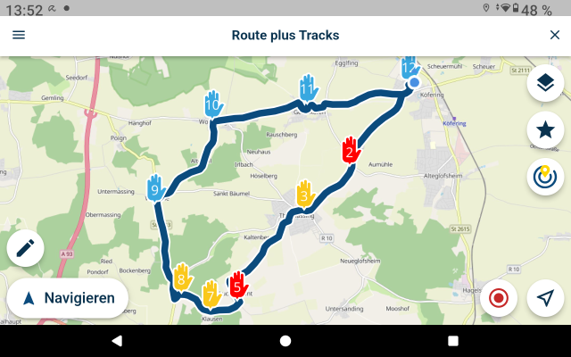
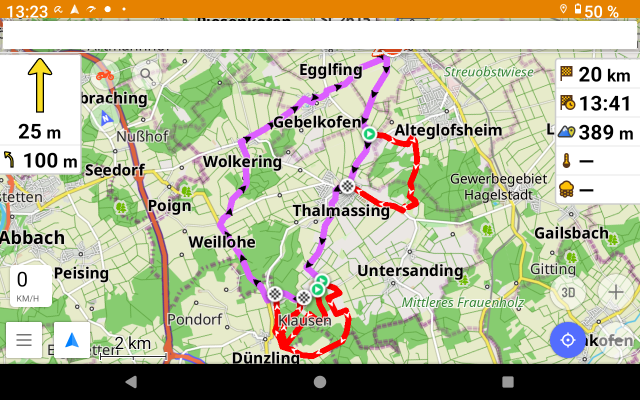
However, other apps can do this - display several tracks at the same time. They are stored individually in the app, even if they were contained together in a GPX file. But you can always choose which of them you want to see on the map:DMD2-App:
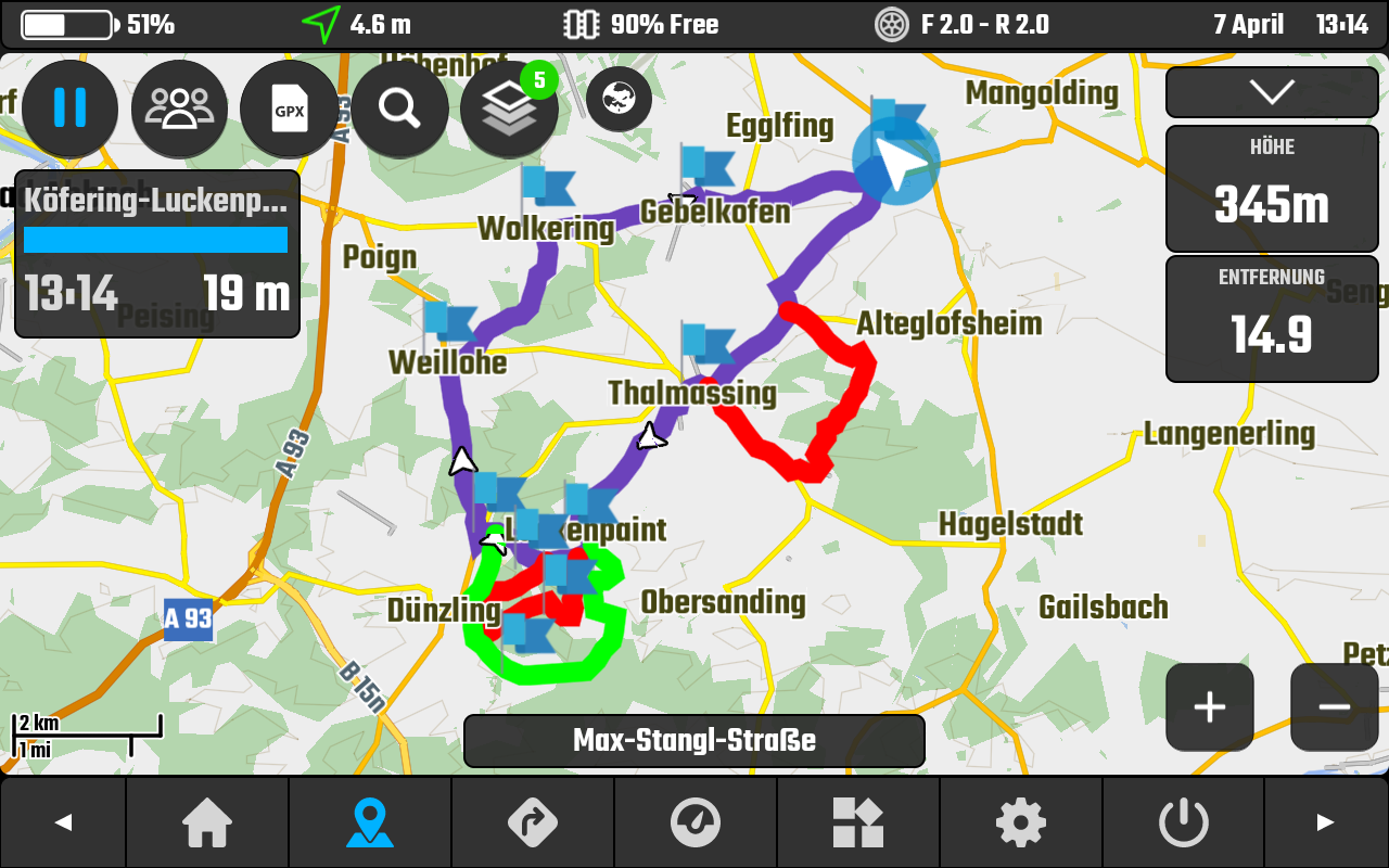
LocusMaps App:
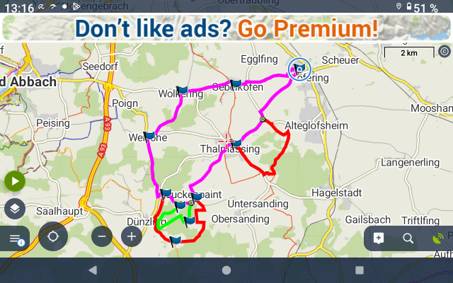
OsmAnd App:
Das ist sehr nützlich, wenn es vom Veranstalter aus schon vorgesehene Alternativstrecken gibt.
Es ist für den Veranstalter schon einfacher, die GPX zu erstellen, ohne aufwändig darstellen zu müssen, wo eine Alternative beginnt, und wo sie wieder zurück auf den Hauptweg kommt.
Und für den Fahrer ist es auch einfacher - beim Fahren zuerkennen, wo die Alternative ist. Ohne eine neue Datei aufrufen zu müssen.
...........................
This is very useful if the organizer has already planned alternative routes.
It is easier for the organizer to create one GPX without having big effort to show where an alternative starts and where it comes back to the main route.
And it is also easier for the rider - to recognize where the alternative is while riding. Without having to open a new file. -
Ok, jetzt verstehe ich. Danke!
Das ist aber dann schon ein sehr besonderer Fall.
Ob das sinnvoll für alle ist, glaube ich nicht.Hardware
iPhone 12 pro (iOS 26.2.1)
iPad (7.Gen.) 18.7.3
Oukitel RT3 Pro (Andr. 14)
Wireless CarPlay mit (Elebest C650)
Wired CarPlay (SEAT Arona - 2021)
MRA Workshops in Deutsch sind hier zu finden -
Ok, jetzt verstehe ich. Danke!
Das ist aber dann schon ein sehr besonderer Fall.
Ob das sinnvoll für alle ist, glaube ich nicht.@Jörgen das Angebot solcher zum Teil (soft)Offroad-Veranstaltungen ist wirklich groß. Und ein Teilnehmerfeld von 100 bis 400 Fahrern ist da immer gegeben. Das gleichzeitige Darstellen von möglichen Alterbativ-Strecken ist da immer üblich.
Ich liebe aber MyRoute-App und möchte es daher auch gerne dazu verwenden.
-
Ok, jetzt verstehe ich. Danke!
Das ist aber dann schon ein sehr besonderer Fall.
Ob das sinnvoll für alle ist, glaube ich nicht.@Jörgen said in making more than 1 track visible in same view:
Ok, jetzt verstehe ich. Danke!
Das ist aber dann schon ein sehr besonderer Fall.
Ob das sinnvoll für alle ist, glaube ich nicht.I disagree, this is also an option I miss.
-
Is anyone able to help me?
Some event organizers hand over a GPX files for the planned day, which contains several tracks (e.g. the main track and alternative sections).-
First part:
In MRA-Routeplanner it is possible to add further routes or tracks to a ROUTE, in order to view them all together. But when exporting, however, only the main route is included in the GPX file.
But it is not possible to add further routes or tracks to a TRACK, in order to view them all together. So, it's understandable, there is only one track in the GPX file after export. -
Second part:
How can I display more than one track in MyRoute-App?
I don't need guided navigation (by icons and speech) - it's enough if I can make more than just one track visible on the map.
Other navigation tools such as the DMD2 app, OsmAnd or LocusMaps can do this.
@Guzzist said in making more than 1 track visible in same view:
Other navigation tools such as the DMD2 app, OsmAnd or LocusMaps can do this.
Those tools are, much more than MRA currently, targeted at outdoor and offroad use. Showing tracks which you are not navigating makes more sense in those use cases. I agree though it would benefit some if this was implemented. I am also afraid that for some people the app is already too complicated as it is. It is no shame to use the right tool for the right job
.I am just an enthusiastic MRA user, and hope you will be one too!
Most motorcycle problems are caused by the nut that connects the handlebar to the saddle.
Check out RideSleepRepeat.eu, a biker community for sharing stays across Europe
-
-
@Guzzist said in making more than 1 track visible in same view:
Other navigation tools such as the DMD2 app, OsmAnd or LocusMaps can do this.
Those tools are, much more than MRA currently, targeted at outdoor and offroad use. Showing tracks which you are not navigating makes more sense in those use cases. I agree though it would benefit some if this was implemented. I am also afraid that for some people the app is already too complicated as it is. It is no shame to use the right tool for the right job
.@Con-Hennekens I fully agree with you, we have to be careful to keep the app as simple as possible.
But it was the Unic Selling Point for the whole platform MyRoute-App, to be like a "Swiss Army knife". And I love it, to do most of needed things by travelling in this one tool.
I don't believe MyRoute-App is complicated. But for sure, without reading tutorials, not every thing is directly understandable.No one should believe - without guidance- its that simple to sit in a Ferrari or a Truck - and start easily driving.
This tool is really the best. And on the market, there are enough "easy" tools - but they don't cover all needs.
Also, in our Community, there are not only users who are only going for a Sunday afternoon Coffe ride - and are satisfied with a round trip about 2 hours, which can be planned by 3 finger taps...Nothing is impossible ;-)
In past: GARMIN Zumo 210->GARMIN Zumo 395->GARMIN XT=> now: DMD T865-X + MyRoute-App, LocusMaps, OsmAnd.
In past: GARMIN MapSource ->GARMIN BaseCamp->Tyre->Kurviger->Calimoto=> now: MRA-Routplanner. -
@Con-Hennekens I fully agree with you, we have to be careful to keep the app as simple as possible.
But it was the Unic Selling Point for the whole platform MyRoute-App, to be like a "Swiss Army knife". And I love it, to do most of needed things by travelling in this one tool.
I don't believe MyRoute-App is complicated. But for sure, without reading tutorials, not every thing is directly understandable.No one should believe - without guidance- its that simple to sit in a Ferrari or a Truck - and start easily driving.
This tool is really the best. And on the market, there are enough "easy" tools - but they don't cover all needs.
Also, in our Community, there are not only users who are only going for a Sunday afternoon Coffe ride - and are satisfied with a round trip about 2 hours, which can be planned by 3 finger taps...@Guzzist fully agree. There should be a separate expert user setup list
 but the setup list they have now is already to advanced for some users.... To much option..
 -
That is something i also suggested a while ago. In some way the app is already too complicated.
-
@Con-Hennekens I fully agree with you, we have to be careful to keep the app as simple as possible.
But it was the Unic Selling Point for the whole platform MyRoute-App, to be like a "Swiss Army knife". And I love it, to do most of needed things by travelling in this one tool.
I don't believe MyRoute-App is complicated. But for sure, without reading tutorials, not every thing is directly understandable.No one should believe - without guidance- its that simple to sit in a Ferrari or a Truck - and start easily driving.
This tool is really the best. And on the market, there are enough "easy" tools - but they don't cover all needs.
Also, in our Community, there are not only users who are only going for a Sunday afternoon Coffe ride - and are satisfied with a round trip about 2 hours, which can be planned by 3 finger taps...@Guzzist said in making more than 1 track visible in same view:
But it was the Unic Selling Point for the whole platform MyRoute-App, to be like a "Swiss Army knife"
Haha, yes, that's true
I know devs are thinking about more offroad compatibility. I think when that gets developed it makes more sense to have tracks visible in the background. But it is probably a long term wish I am afraid.
Hello! It looks like you're interested in this conversation, but you don't have an account yet.
Getting fed up of having to scroll through the same posts each visit? When you register for an account, you'll always come back to exactly where you were before, and choose to be notified of new replies (either via email, or push notification). You'll also be able to save bookmarks and upvote posts to show your appreciation to other community members.
With your input, this post could be even better 💗
Register Login-
7903.6k
-
017224
-
0317
-
737481
-
317978
-
0229
-
121627
-
03100