An ability to temporarily disable a waypoint
-
Hello.
I use MRA for all my planning. However, I often find a need to compare the route using one waypoint, or a set of waypoints, against (an)other(s).
It would be enourmously useful if one could enable/disable waypoints whilst still keeping them in the list rather than having to delete them and then re-enter them. Aslo, not essential, but "nice to have" it would be useful if one could highlight a succession of waypoints in order to block enable/disable them as a group.
I know that you can copy the original route, then modify the copy, but having to switch between the two routes to compare is not an eficient method. Not only is it "clunky", but it makes the Route Folder very messy with a bunch of "experimental" or copy routes that you don't want, and then have to delete with the consequent danger of eliminating the wrong one.
Perhaps another suggestion, then, is to make the "copy" routes a diffent title colour in order to easily distinguish them. The space for the name of the route is too short to see whether it's an original or a copy. Yes, you can click the "edit" tab, but, as I say, it's clunky, or as we say in the UK: it's a bit Heath Robinson.
regards.
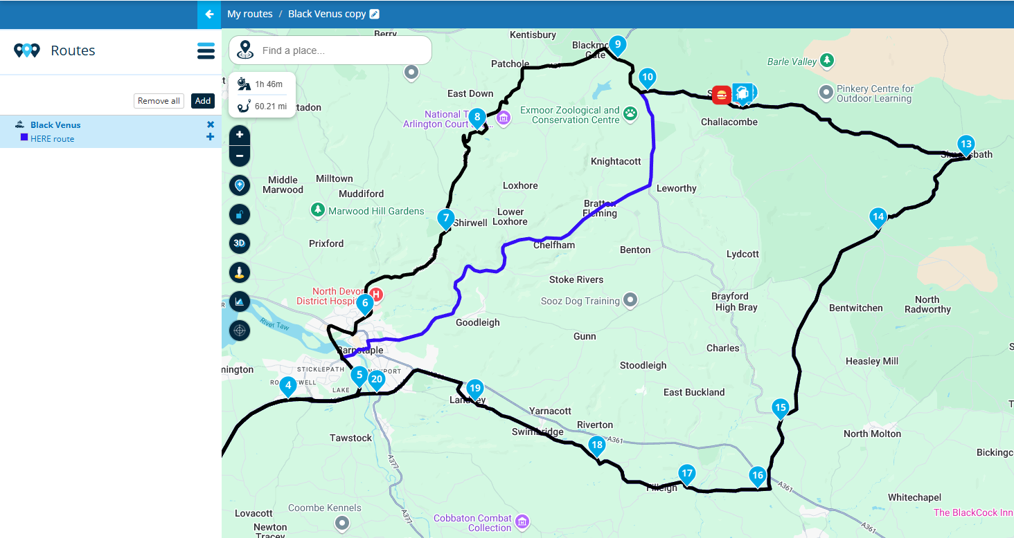
@Fred-1t Is this the sort of thing that you're after? The copy of the route is in black and editable the original route is shown in blue.
Always willing to help if I can.
Triumph Tiger 1200 XRT called Tina.
MRA Navigation Next and SilverFox BJ8 -
@Fred-1t Is this the sort of thing that you're after? The copy of the route is in black and editable the original route is shown in blue.
Original route in blue.
First copy in red.
Second copy (editable) in black.
All routes use route points 13 - 20.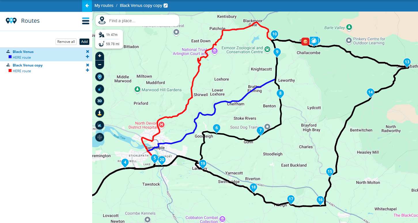
Always willing to help if I can.
Triumph Tiger 1200 XRT called Tina.
MRA Navigation Next and SilverFox BJ8 -
Original route in blue.
First copy in red.
Second copy (editable) in black.
All routes use route points 13 - 20.@Nick-Carthew Hi Nick, thanks for your reply.
Yeah, it's a fix or workaround of sorts, but not exactly what I'm after. I'm assuming that what you've done there is to copy the route, you've then modified the copy, and then "added" it to the original route so that you get a superimposition. Largely academic for my purposes, but the problem I see with this function of adding a route to a route (for me) is that because black is darker than blue, any part of the blue route that is shared with the black route, becomes invisible. It's not obvious, for example, if the blue route is west of the blue line, or east of the blue line
If the answer to the following question is YES, then the rest of my post is (partly) irrelevant: Can you toggle between the blue route and the black route individually? If so, that would be a half way solution to my idea, but still clunky.
If the answer is NO.....
Then other than obtaining a global view of a tour as a whole once a series of routes have been planned for each day, I don't really see much point in the ability to add a route to another unless you have the ability to toggle each route on and off. So I'd have three ways of seeing the route: The black route only, the blue route only, or, as in your ilustration, both together.
What I'm really after is the ability to toggle a section of a planned route on and off by disabling certain waypoints so that I can instantly compare distance and time.
So, a perfect illustration of this; using your map above, would be to disable waypoints 6 - 9 (black line) and leave the blue line with the rest of the waypoints intact. I would then eliminate the waypoints that connect the blue line (none on your map) and re-enable waypoints 6-9. Instantly I'd be able to see the difference in time and distance all on the same route.
ride safe
-
@Nick-Carthew Hi Nick, thanks for your reply.
Yeah, it's a fix or workaround of sorts, but not exactly what I'm after. I'm assuming that what you've done there is to copy the route, you've then modified the copy, and then "added" it to the original route so that you get a superimposition. Largely academic for my purposes, but the problem I see with this function of adding a route to a route (for me) is that because black is darker than blue, any part of the blue route that is shared with the black route, becomes invisible. It's not obvious, for example, if the blue route is west of the blue line, or east of the blue line
If the answer to the following question is YES, then the rest of my post is (partly) irrelevant: Can you toggle between the blue route and the black route individually? If so, that would be a half way solution to my idea, but still clunky.
If the answer is NO.....
Then other than obtaining a global view of a tour as a whole once a series of routes have been planned for each day, I don't really see much point in the ability to add a route to another unless you have the ability to toggle each route on and off. So I'd have three ways of seeing the route: The black route only, the blue route only, or, as in your ilustration, both together.
What I'm really after is the ability to toggle a section of a planned route on and off by disabling certain waypoints so that I can instantly compare distance and time.
So, a perfect illustration of this; using your map above, would be to disable waypoints 6 - 9 (black line) and leave the blue line with the rest of the waypoints intact. I would then eliminate the waypoints that connect the blue line (none on your map) and re-enable waypoints 6-9. Instantly I'd be able to see the difference in time and distance all on the same route.
ride safe
@Fred-1t I appreciate my suggestion is not what you are requesting and as you have already stated, it is just a workaround.
Adjusting the transparency of the route line goes some way to addressing your concern about not seeing other route lines.
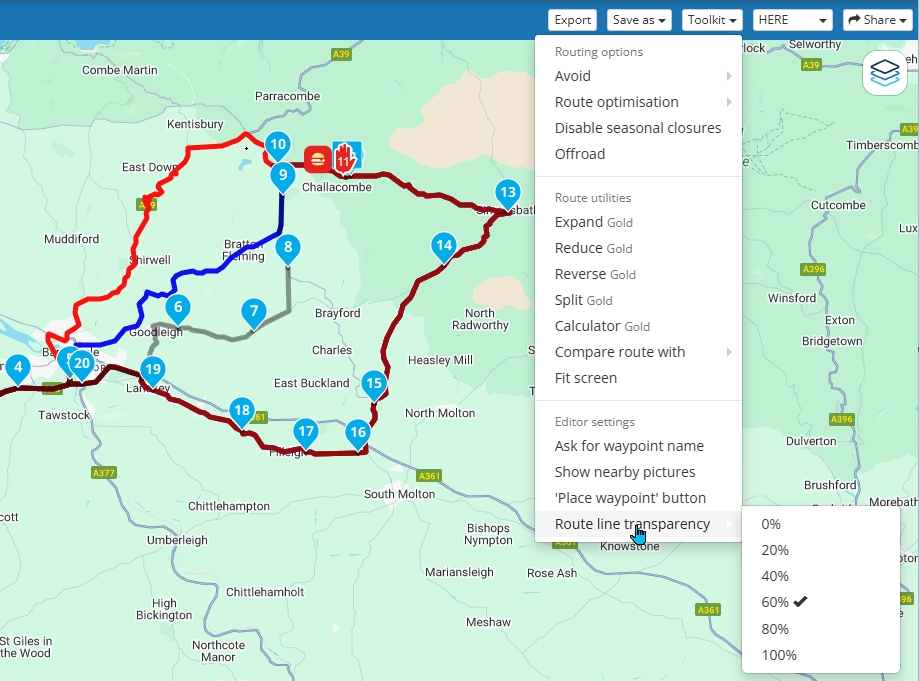
And the answer to your question is no.
Always willing to help if I can.
Triumph Tiger 1200 XRT called Tina.
MRA Navigation Next and SilverFox BJ8 -
Hello.
I use MRA for all my planning. However, I often find a need to compare the route using one waypoint, or a set of waypoints, against (an)other(s).
It would be enourmously useful if one could enable/disable waypoints whilst still keeping them in the list rather than having to delete them and then re-enter them. Aslo, not essential, but "nice to have" it would be useful if one could highlight a succession of waypoints in order to block enable/disable them as a group.
I know that you can copy the original route, then modify the copy, but having to switch between the two routes to compare is not an eficient method. Not only is it "clunky", but it makes the Route Folder very messy with a bunch of "experimental" or copy routes that you don't want, and then have to delete with the consequent danger of eliminating the wrong one.
Perhaps another suggestion, then, is to make the "copy" routes a diffent title colour in order to easily distinguish them. The space for the name of the route is too short to see whether it's an original or a copy. Yes, you can click the "edit" tab, but, as I say, it's clunky, or as we say in the UK: it's a bit Heath Robinson.
regards.
@Fred-1t, I think if you make use of favorite points, it is easy to ad / delete /re-add waypoints at your favorite points. Maybe that is useful for you?
@Fred-1t said in An ability to temporarily disable a waypoint:
So I'd have three ways of seeing the route: The black route only, the blue route only, or, as in your ilustration, both together.
Hmm, If I translate how my illustration program works, you can have multiple objects on a page, and click them to become editable, place or move nodes. Having multiple route active in a view could be very interesting, each with separate waypoints colors and maybe settings. Select one you can edit that one, select the other you can edit the other. Useful for multiday tours I think. Interesting suggestion! But probably difficult to implement, I don't know.
-
Thanks, chaps.
Hi Con, no, that isn't a solution for me and it's till a clunky way.
it was a suggestion for future iterations of MRA. I don't really understand programming, but I can't imagine it would be that difficult to code in. Afterall, it's just a case of coding in an off or on switch to the waypoint.
Anyway, we shall see if this has legs.
cheers, all.
Ride Safe

-
@Fred-1t I appreciate my suggestion is not what you are requesting and as you have already stated, it is just a workaround.
Adjusting the transparency of the route line goes some way to addressing your concern about not seeing other route lines.
And the answer to your question is no.
-
@Fred-1t Is this the sort of thing that you're after? The copy of the route is in black and editable the original route is shown in blue.
@Nick-Carthew Great idea, I would often need this function too

Hello! It looks like you're interested in this conversation, but you don't have an account yet.
Getting fed up of having to scroll through the same posts each visit? When you register for an account, you'll always come back to exactly where you were before, and choose to be notified of new replies (either via email, or push notification). You'll also be able to save bookmarks and upvote posts to show your appreciation to other community members.
With your input, this post could be even better 💗
Register Login-
7553.0k
-
0983
-
017462
-
05109
-
0258
-
115728
-
0114