Is there any plan to allow the stitching together of tracks?
-
Whilst it is very easy to convert a track into a route and then check that the route offered up, matches the line of the track. I was wondering if there is any plan by the developers to allow the stitching together of tracks.
Whilst I long ago gave up using BaseCamp or MapSource, switching entirely to MyRoute, the stitching together of tracks was a useful feature that both MapSource and BaseCamp offered.
Here’s good example of where it might be useful. I want to ride some (hopefully all) of the 8,000 miles (22,900 km) of the German Motorcycle Route. The Motorrad Strassen website (very helpfully) proves GPX track files for each of the four 2,000 mile routes. But, the track files are themselves broken down into short sections. For example, the northern section is divided into 18 individual sections. I can download each of the 18 sections of track, but I cannot (in MyRoute) join them together. The only workaround I know of is to convert each of the 18 tracks into 18 individual routes. Then check that the routes offered up match the tracks. Then correct any anomalies. Then stitch the 18 individual routes together. I’d have to repeat this process four times. OK, it’s not hard to do but it does take time.
Is there any easier and reliable way or, better still, any way to stitch tracks together now or in the future?
Look forward to news or views.
Thanks.
Richard
-
Stitching tracks has little to do with planning routes. There is a whole lot of stuff you can look for on the internet though:
https://www.google.com/search?q=merge+gpx+tracksI am just an enthusiastic MRA user, and hope you will be one too!
Most motorcycle problems are caused by the nut that connects the handlebar to the saddle.
Check out RideSleepRepeat.eu, a biker community for sharing stays across Europe
-
Whilst it is very easy to convert a track into a route and then check that the route offered up, matches the line of the track. I was wondering if there is any plan by the developers to allow the stitching together of tracks.
Whilst I long ago gave up using BaseCamp or MapSource, switching entirely to MyRoute, the stitching together of tracks was a useful feature that both MapSource and BaseCamp offered.
Here’s good example of where it might be useful. I want to ride some (hopefully all) of the 8,000 miles (22,900 km) of the German Motorcycle Route. The Motorrad Strassen website (very helpfully) proves GPX track files for each of the four 2,000 mile routes. But, the track files are themselves broken down into short sections. For example, the northern section is divided into 18 individual sections. I can download each of the 18 sections of track, but I cannot (in MyRoute) join them together. The only workaround I know of is to convert each of the 18 tracks into 18 individual routes. Then check that the routes offered up match the tracks. Then correct any anomalies. Then stitch the 18 individual routes together. I’d have to repeat this process four times. OK, it’s not hard to do but it does take time.
Is there any easier and reliable way or, better still, any way to stitch tracks together now or in the future?
Look forward to news or views.
Thanks.
Richard
I'd suggest GPX Studio for this job, where you can easily
- open all tracks in one go
- select all
- merge
- export
Where did you get the MSD tracks from? Is there a more convenient way than opening every single one in Kurviger and exporting as a track?
-
Stitching tracks has little to do with planning routes. There is a whole lot of stuff you can look for on the internet though:
https://www.google.com/search?q=merge+gpx+tracks@Con-Hennekens said in Is there any plan to allow the stitching together of tracks?:
Stitching tracks has little to do with planning routes. There is a whole lot of stuff you can look for on the internet though:
https://www.google.com/search?q=merge+gpx+tracksThank you.
I agree, it has very little to do with planning at all; zero in fact. To be brief, I want to follow (as closely as possible) the trail of the German Motor Cycle route’s 8,000 mile progress around Germany. To do that, I need to convert the tracks into routes. Of course I could just leave them as tracks and use those to navigate by.
The ‘planning’ part will come in when I see how I can mix in as a many UNESCO heritage sites as I can visit, whilst:
A. Remembering that my plan is to ride the four legs of the route, not to necessarily spend hours and hours looking at a Prussian palace or preserved iron works, as interesting as they might be.
B. To do the lot in say 60 days ie. Not take 100 or rush around it all in 20 days.
This is what I have so far:
The PDF maps from the Motorrad Strassen website. Plus the four routes (converted from tracks) with the UNSCO world heritage sites superimposed on top:
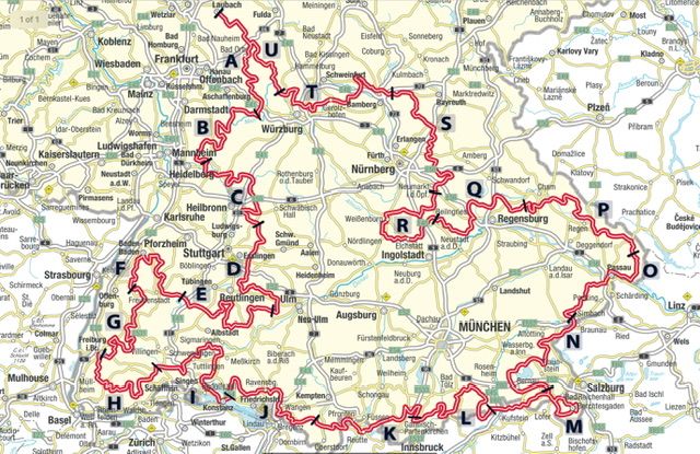
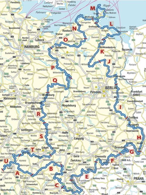
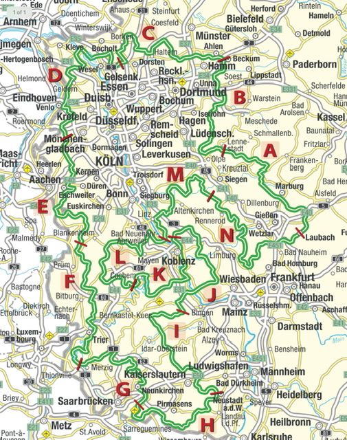
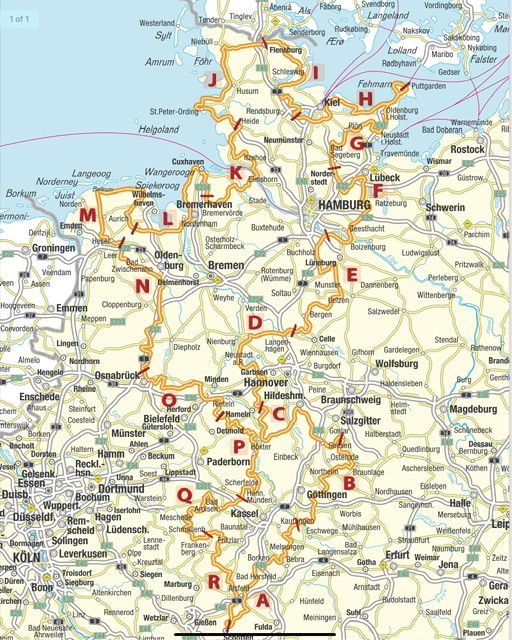
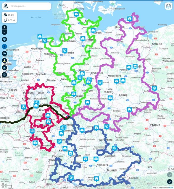
8,000 miles (plus excursions) all within the boundaries of Germany. I have already ridden right around the outer edges of huge country, lapping it in a clockwise direction. This will fill in most of the middle, which (I guess) was the intention of the fellow who conceived the German Motorcycle Route in the first place.
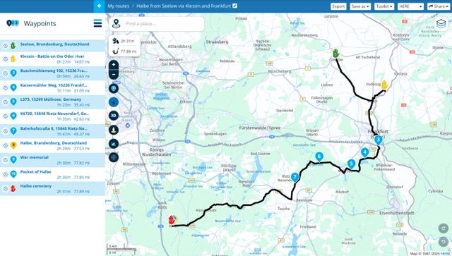
I also hope to plan in the finishing off of my recent visit to the Hürtgen Forest and to see the sites and sights of the Fall of Berlin and the dreadful events of Halbe Pocket:
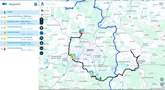
Then extending that excursion to take in Zossen, Potsdam and Oranienburg:
That does require some ‘planning’ and route creation, all be it fairly simple.
-
I'd suggest GPX Studio for this job, where you can easily
- open all tracks in one go
- select all
- merge
- export
Where did you get the MSD tracks from? Is there a more convenient way than opening every single one in Kurviger and exporting as a track?
@Martin-Wilcke said in Is there any plan to allow the stitching together of tracks?:
I'd suggest GPX Studio for this job, where you can easily
- open all tracks in one go
- select all
- merge
- export
Where did you get the MSD tracks from? Is there a more convenient way than opening every single one in Kurviger and exporting as a track?
Here:
https://www.motorradstrassen.de/touren/motorradstrasse-deutschland
Is there an easier way? Not unless someone stitches together the individual route segments, which I have now done.
Though inconvenient, it did give me the opportunity to look at the routes and use MyRoute’s excellent ability to display much of them on Google’s Street View. Thankfully, the Germans relented and allowed Google to turn it on, after years of (maybe understandable) resistance.
-
PS I used Garmin’s BaseCamp when I stitched the tracks together originally, way back in lockdown and Covid. They live on my Mac, which I haven’t turned on for three years, as I now do everything on my iPad Pro and in MyRoute.
Now that I actually might have a chance to ride the 8,000 miles next year, I repeated the entire download process and recreated it all in MyRoute. A waste of my time? Maybe so, but it I had other tasks to do in MyRoute at the same time and was using my iPad to research other stuff to maybe include in. It passed the time.
It was this (and this alone) which prompted my question as to whether MyRoute’s owners had any plans to add ‘track stitching together’ in some future update. If they don’t and / or or people don’t see too much of a value in it. So be it. I’m not too fussed.
-
@Con-Hennekens said in Is there any plan to allow the stitching together of tracks?:
Stitching tracks has little to do with planning routes. There is a whole lot of stuff you can look for on the internet though:
https://www.google.com/search?q=merge+gpx+tracksThank you.
I agree, it has very little to do with planning at all; zero in fact. To be brief, I want to follow (as closely as possible) the trail of the German Motor Cycle route’s 8,000 mile progress around Germany. To do that, I need to convert the tracks into routes. Of course I could just leave them as tracks and use those to navigate by.
The ‘planning’ part will come in when I see how I can mix in as a many UNESCO heritage sites as I can visit, whilst:
A. Remembering that my plan is to ride the four legs of the route, not to necessarily spend hours and hours looking at a Prussian palace or preserved iron works, as interesting as they might be.
B. To do the lot in say 60 days ie. Not take 100 or rush around it all in 20 days.
This is what I have so far:
The PDF maps from the Motorrad Strassen website. Plus the four routes (converted from tracks) with the UNSCO world heritage sites superimposed on top:
8,000 miles (plus excursions) all within the boundaries of Germany. I have already ridden right around the outer edges of huge country, lapping it in a clockwise direction. This will fill in most of the middle, which (I guess) was the intention of the fellow who conceived the German Motorcycle Route in the first place.
I also hope to plan in the finishing off of my recent visit to the Hürtgen Forest and to see the sites and sights of the Fall of Berlin and the dreadful events of Halbe Pocket:
Then extending that excursion to take in Zossen, Potsdam and Oranienburg:
That does require some ‘planning’ and route creation, all be it fairly simple.
I have had the same idea (riding the MSD) on my radar for some time now.
When following suggested trips, I always prefer tracks over routes as they stick closer to the original intention or, even better, use tracklogs - I like the idea of following someone's traces.
@Richard-18 said in Is there any plan to allow the stitching together of tracks?:
To do that, I need to convert the tracks into routes.
The MSD Webpage includes links to all MSD parts, which lead to routes provided by Kurviger. Where did you get the tracks?
@Richard-18 said in Is there any plan to allow the stitching together of tracks?:
...my question as to whether MyRoute’s owners had any plans to add ‘track stitching together’ in some future update. If they don’t and / or or people don’t see too much of a value in it.
Even if editing tracks may not be part of a core planning task in MRA (where planning focuses on routes), MRA offers track navigation as well, and there are some capabilities for maintaining tracklogs.
Therefore, IMHO, basic features such as splitting and merging tracks would be conceivable.
Hello! It looks like you're interested in this conversation, but you don't have an account yet.
Getting fed up of having to scroll through the same posts each visit? When you register for an account, you'll always come back to exactly where you were before, and choose to be notified of new replies (either via email, or push notification). You'll also be able to save bookmarks and upvote posts to show your appreciation to other community members.
With your input, this post could be even better 💗
Register Login-
71277.7k
-
112380
-
1550
-
029686
-
0292.0k
-
010443
-
0290
