MRA and the BMW Connected App
-
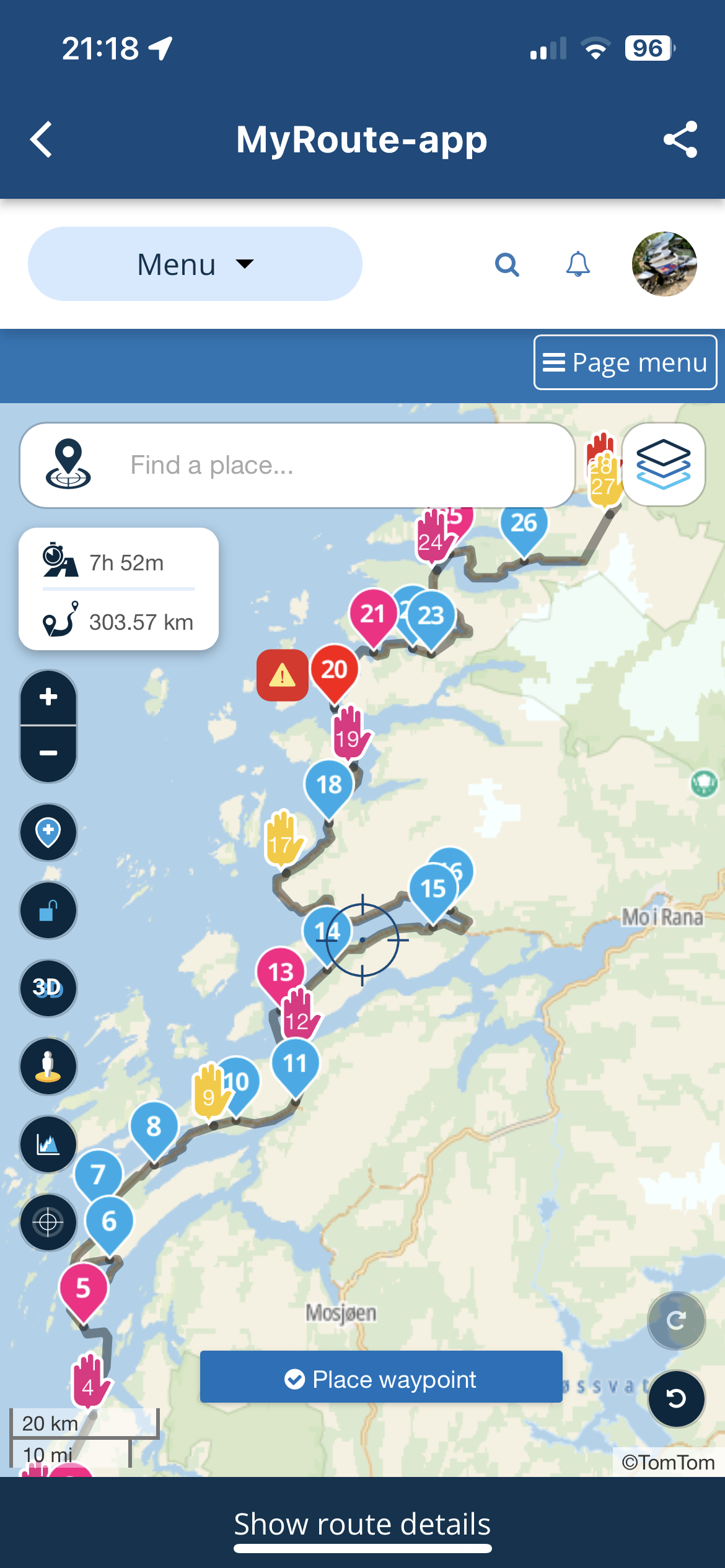
Been enjoying plotting routes for a trip from UK to Nordkapp and back home down Finland et al starting on 29th May, using my new Lifetime Gold Membership (Caveat: BMW Connected App uses TomTom maps, so you need Gold and to plot using those maps). I have a K1600GT where the new 10.25in TFT has 'map view' and the Connected App is nearly 100% functional with it, unlike with my last 3 GS(A)s.
I am also looking forward to MRA-app Next with Navigation for other vehicles, but currently I love being able to use a quality online tool to plot my routes accurately. The beauty of this too is the new simplicity of using the MRA phone app (iPhone in my case) to move the routes WITH WAY/VIA POINTS into the connected app. These waypoints are not exactly as they are set up in MRA. (They seem to take the 'default' TomTom name for the location of your plotted waypoint in MRA not any custom name you give it. NOTE: This has a further advantage when using the 'expand' function in MRA as the MRA default-named 'Waypoint' gets converted to something more meaningful. FURTHER NOTE: There is a fifty waypoint limit in the Connected App).
Below is the process after plotting the route, all on my phone using the two apps.
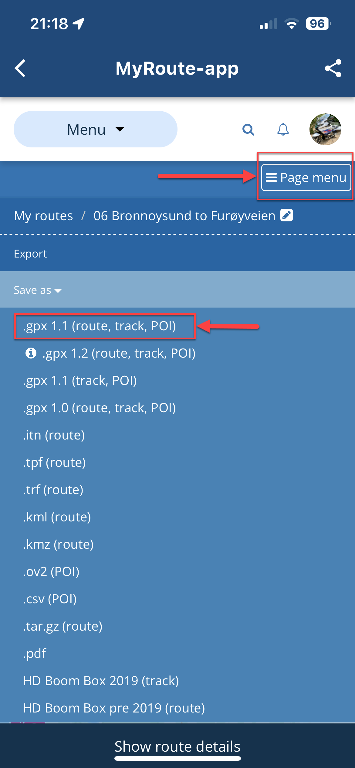
- Open the MRA app and going through Route Lab>Routes, open your route.
- Hit the 'Page menu' and select '.gpx 1.1 (route, track, POI)'
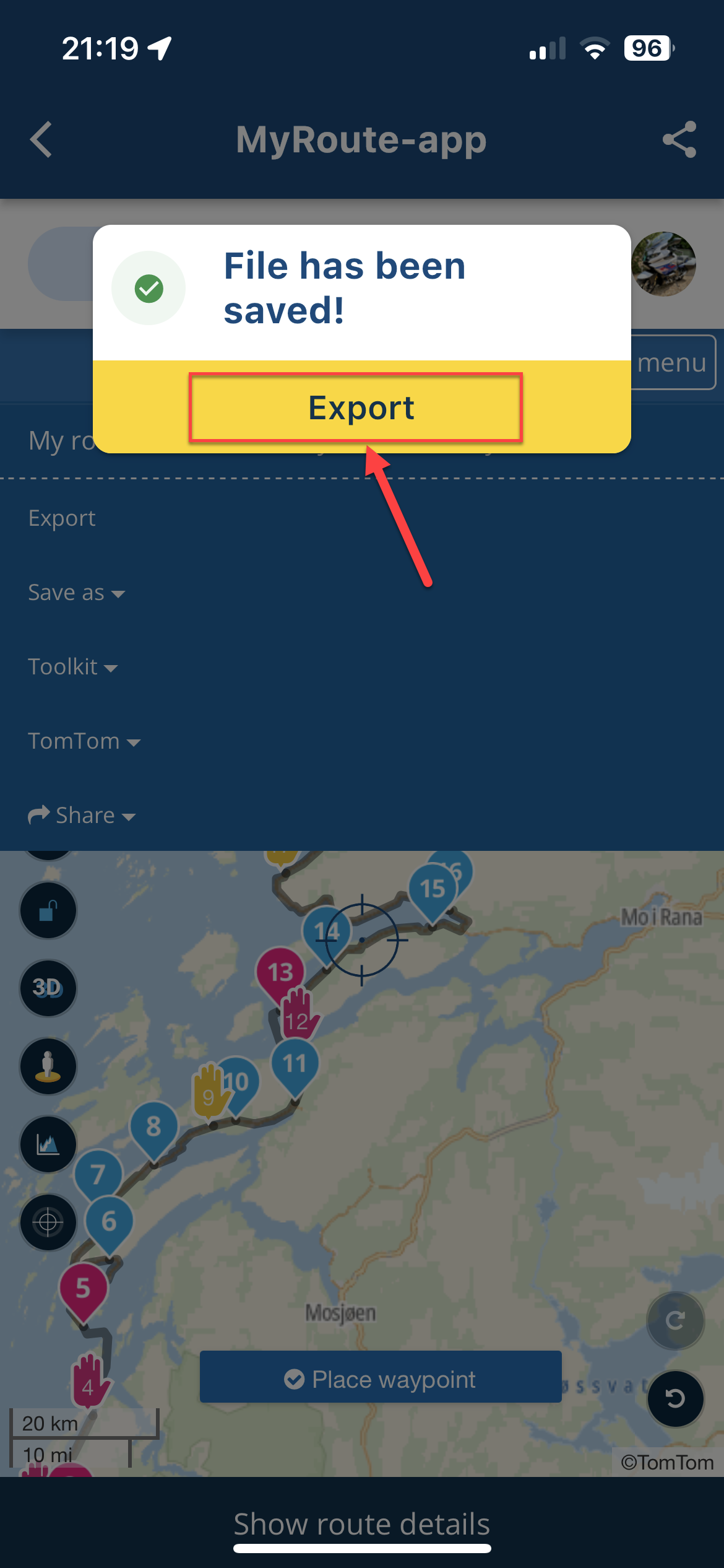
- This will prepare the file for export and present a dialog. Hit 'Export'
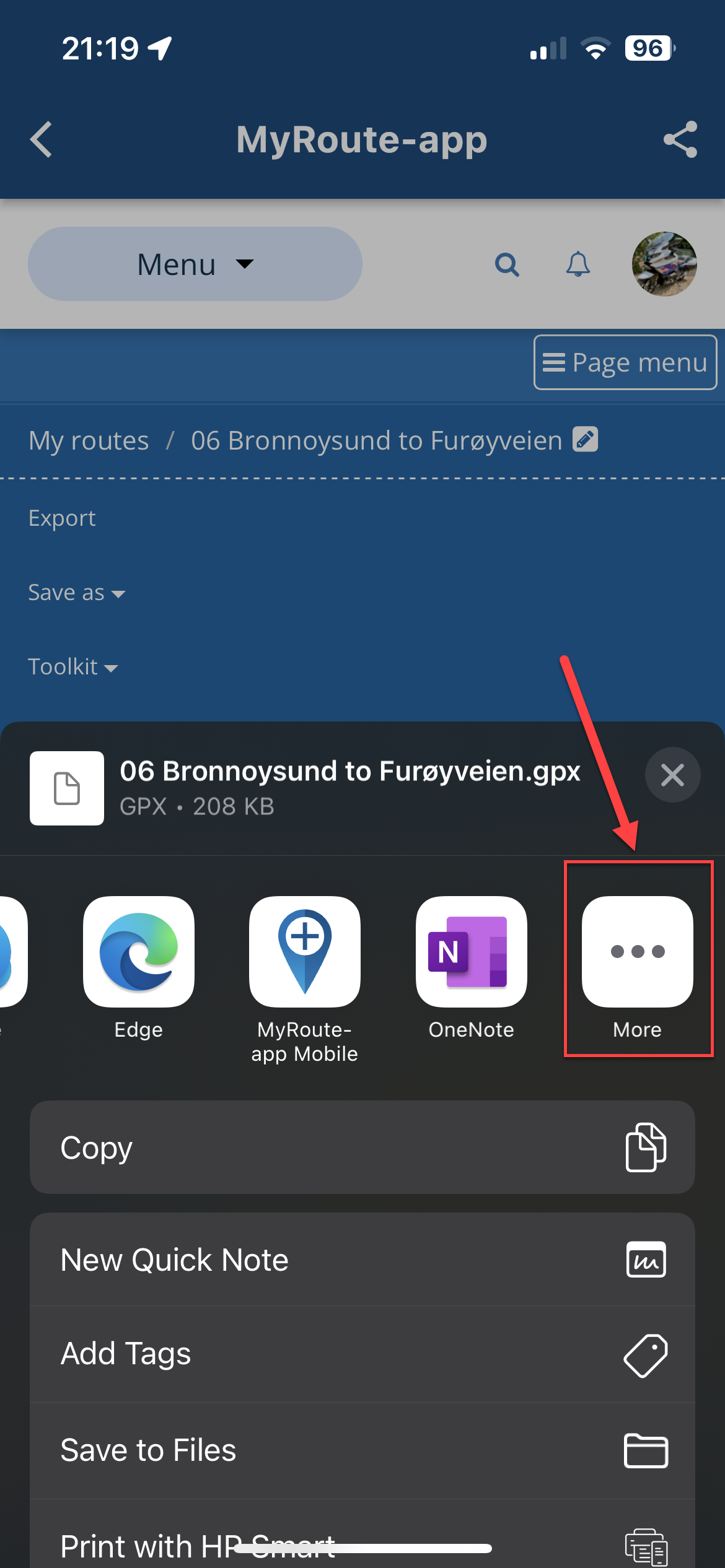
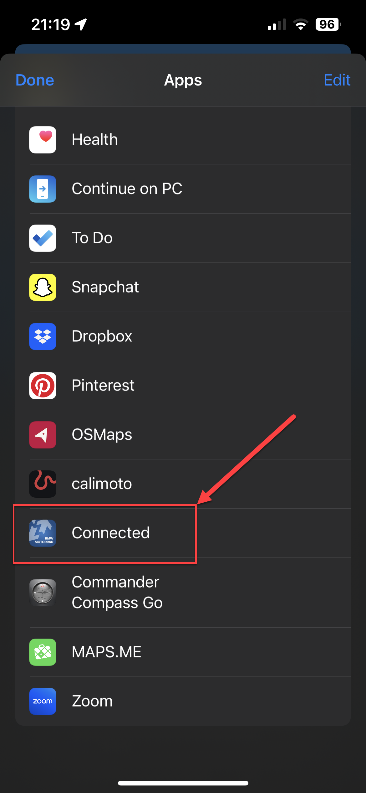
- This will display the 'options list'. Scroll fully right and select 'More'
- From the list, navigate to 'Connected' and click that.
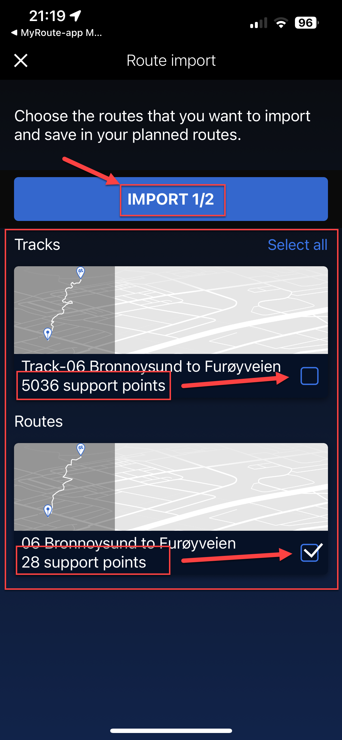
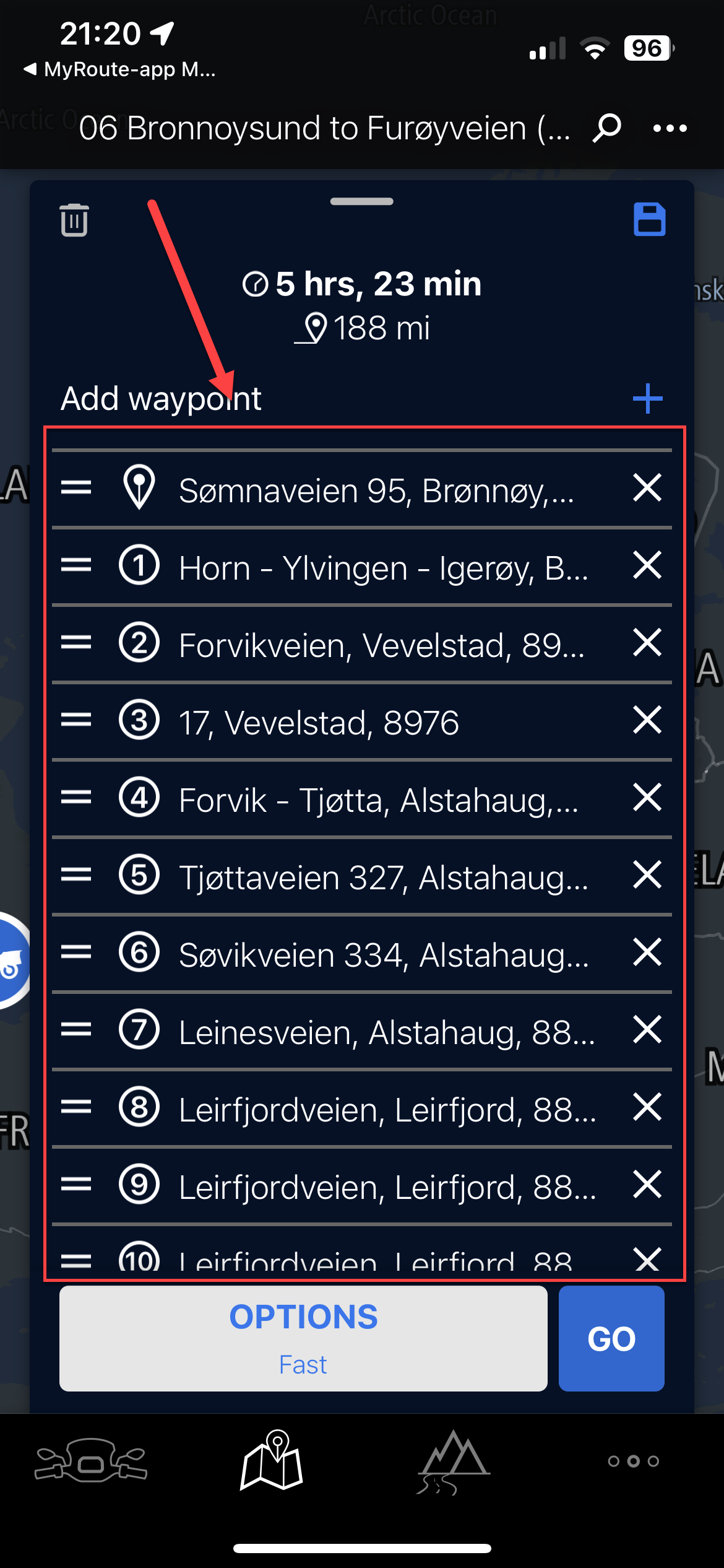
- This will load the two components of the data (Route and Track). You may get a third if you added something from the POI list in MRA. You can ignore this third one entirely. You will notice the track has many points (normally thousands), the route will have the same number of 'Support' points as the Way and Via points in your MRA route. Uncheck the track (and POI if you have a third), so you just have the 'Route' selected. Click 'Import'
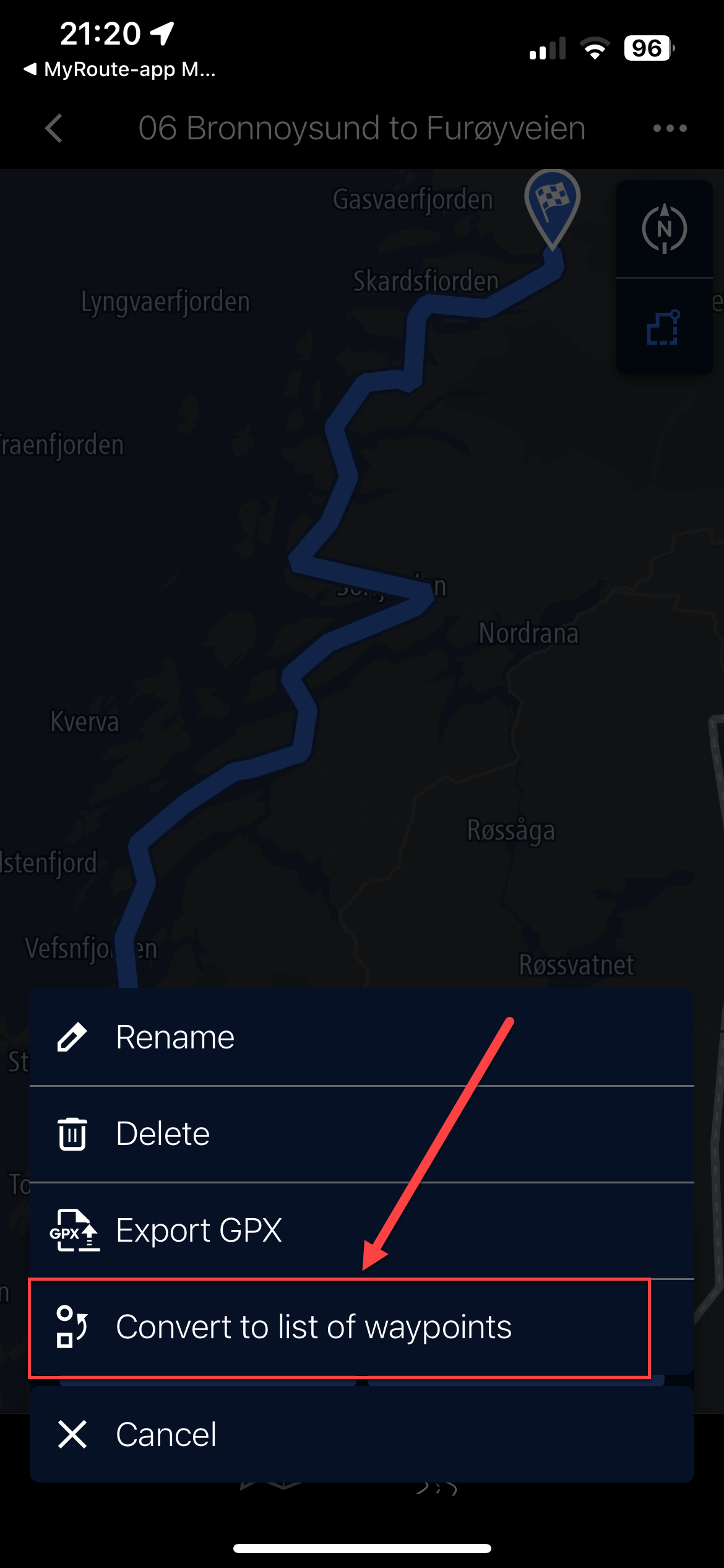
- This will import the route into the BMW Connected App as below, still showing 'Support Points'. Click on the route to open it.
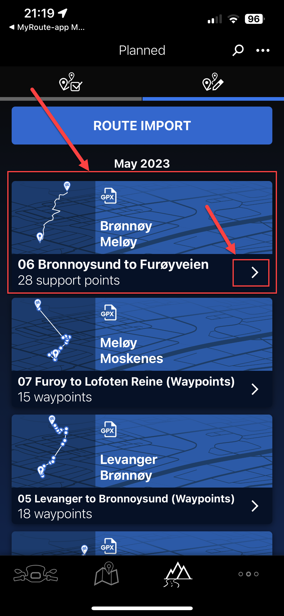
- This will show you a rough representation of the route but no waypoints will be shown. Hit the three buttons top right of this screen (...)
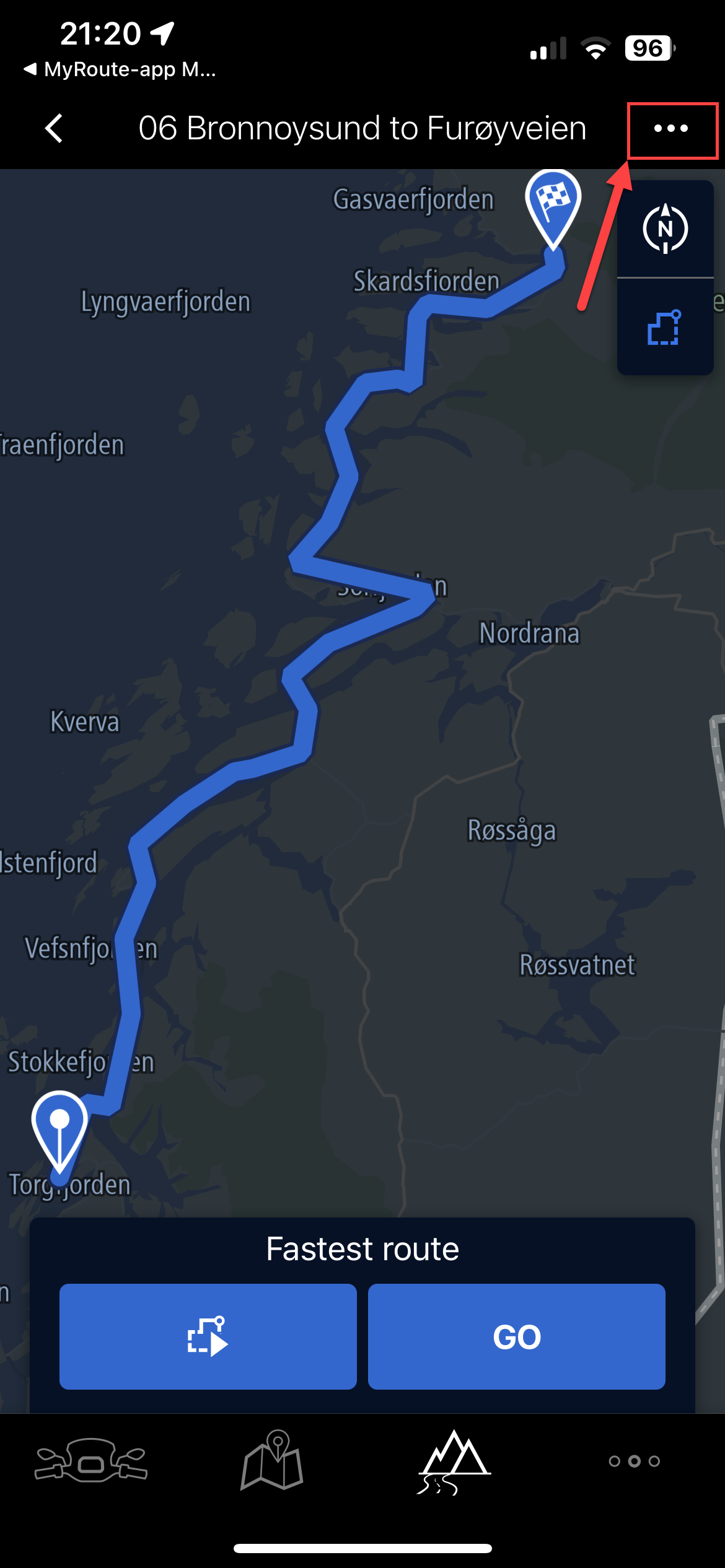
- Select 'Convert to list of waypoints'
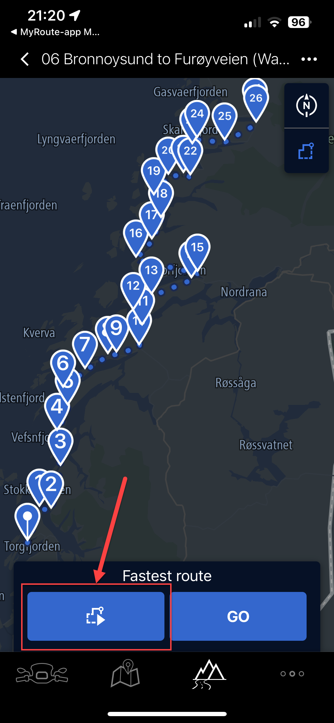
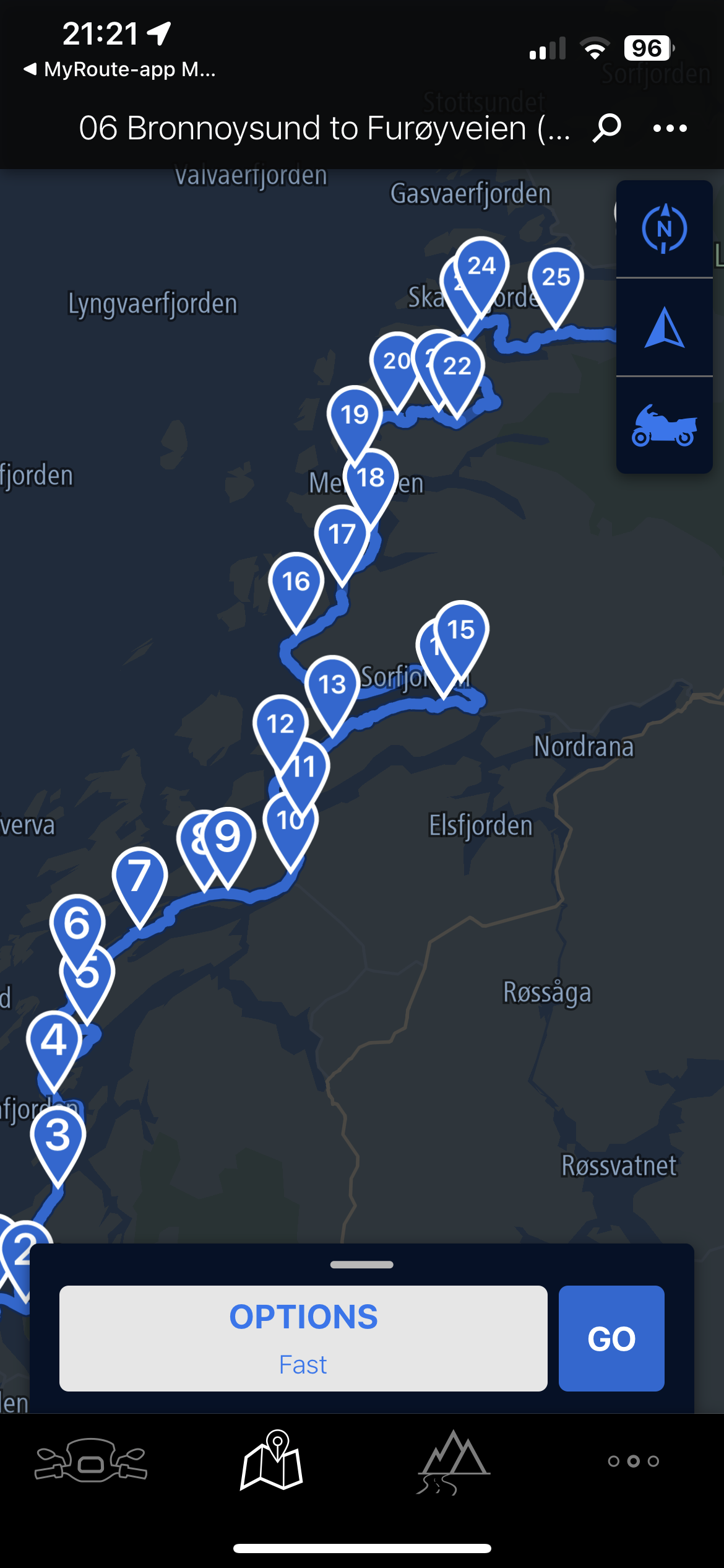
- This will literally plot single dot waypoints on the map in the connected app, with dots joining them. Hit the 'route' button. (as shown)
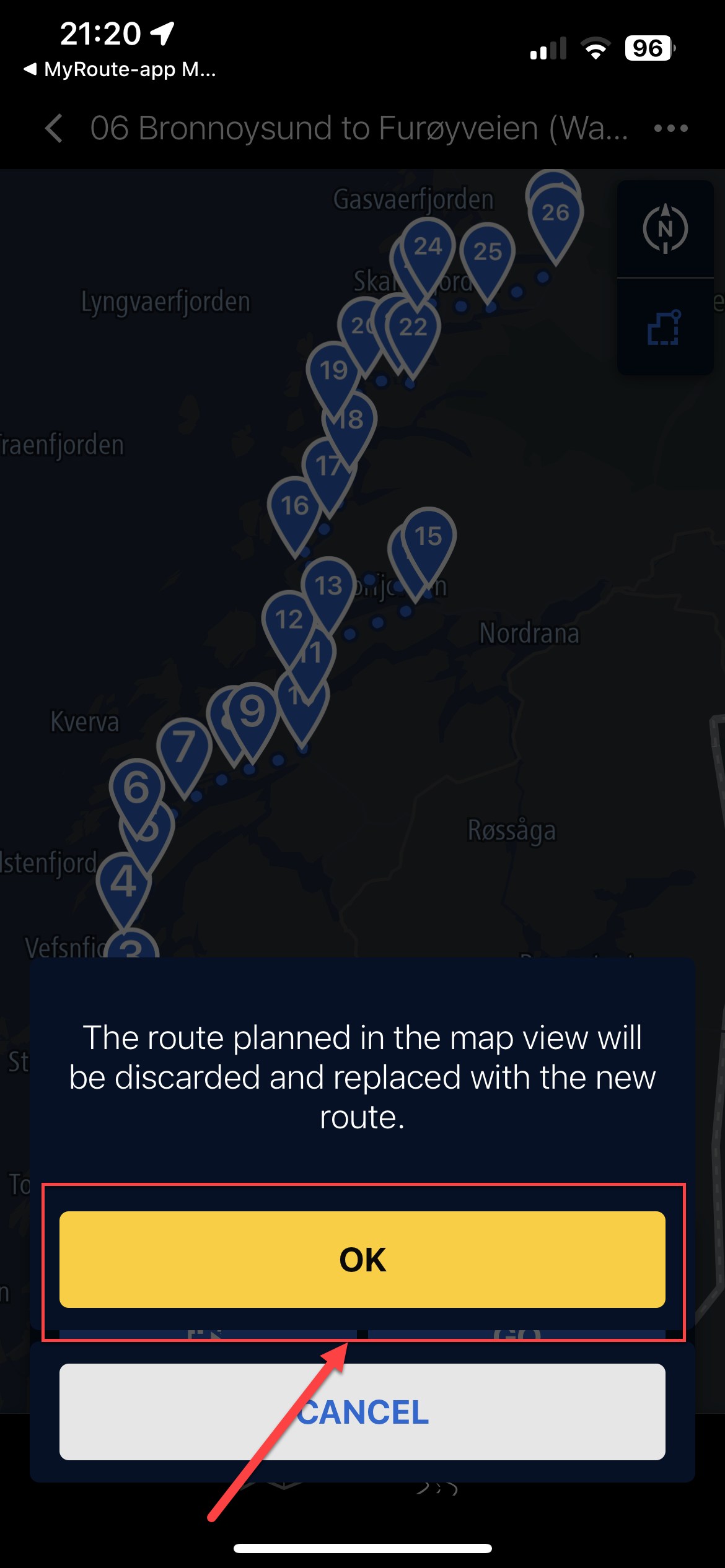
- It warns the current map will be discarded and replaced, select 'OK'
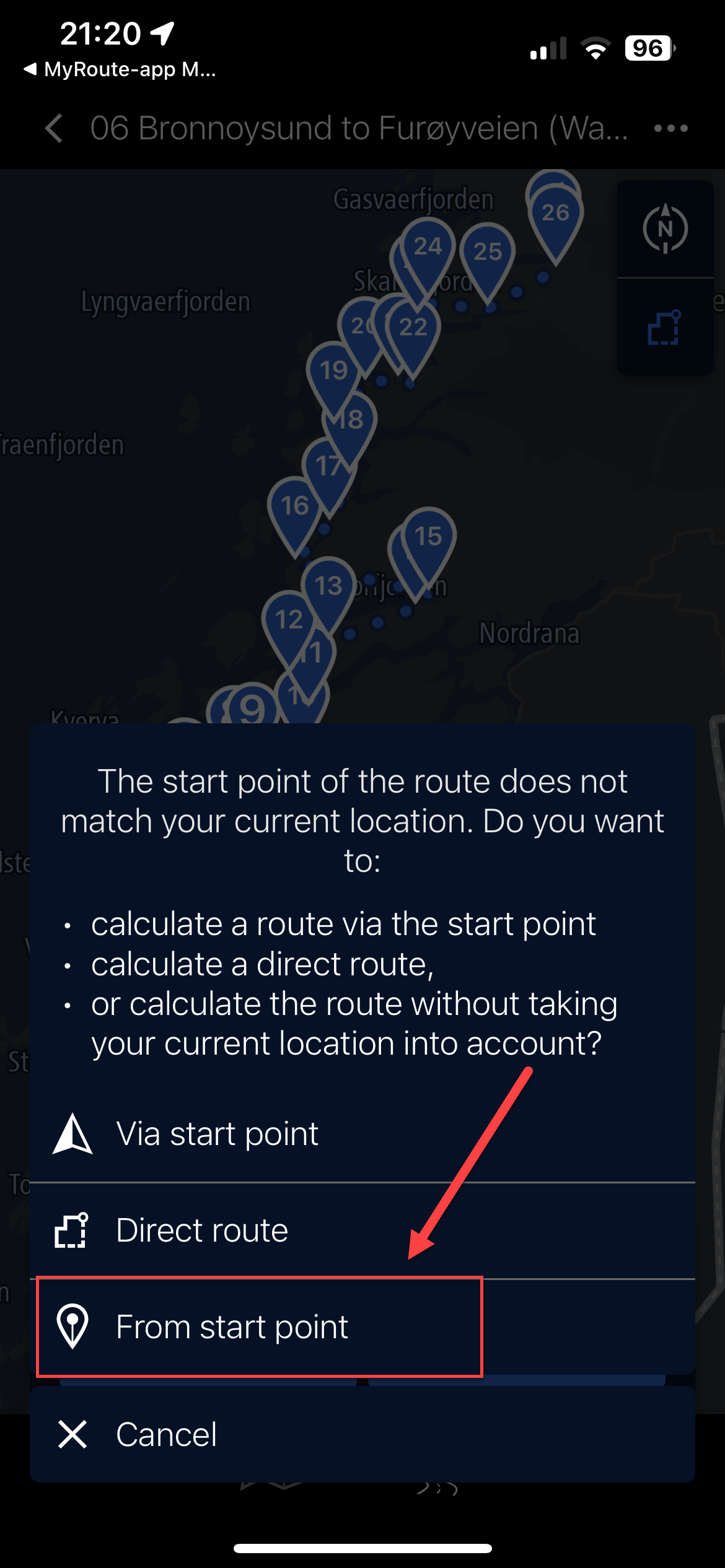
- If you are not near the start point, click 'From start point' and it'll plot the route from waypoint 1 to waypoint (max) on your imported route.
- Not sure if this is the clever point but the Connected app, using the same TomTom map points, grabs the internal waypoint (and name) from the data in the imported route and maps it. Making a full list of named waypoints matching your waypoints in MRA (not by name, but position). These all show as waypoints on the bike's TFT, so can be skipped, announce, etc.
- The route has now been fully built in the Connected App.
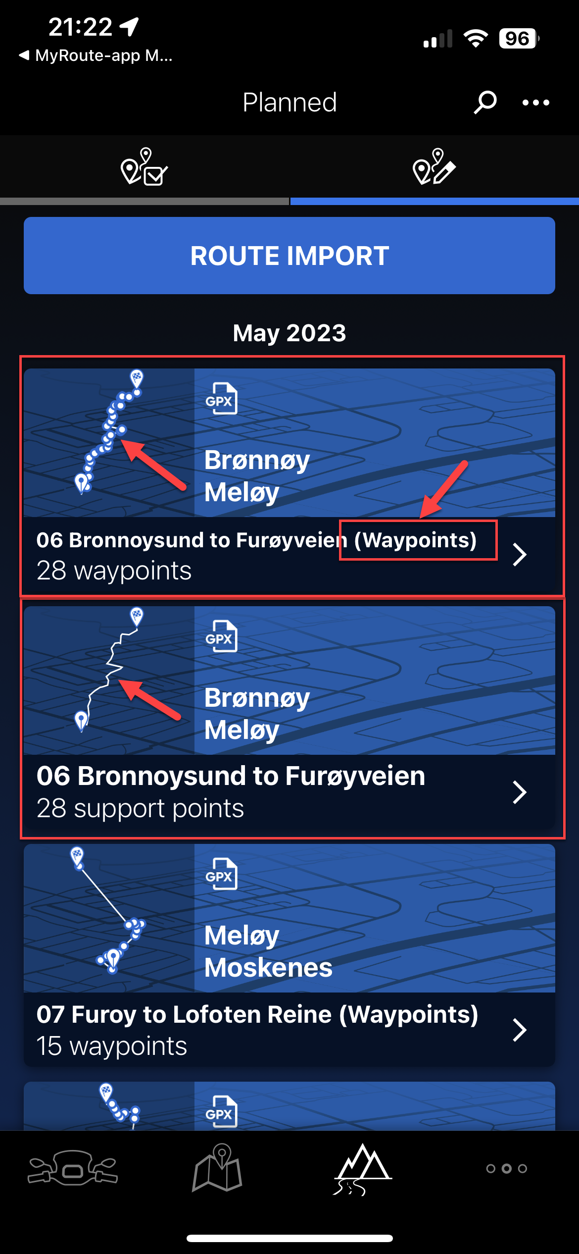
- The route has been saved as a copy and the word '(Waypoints)' has been added. You can keep the old one or delete it. Note too the thumbnail of the route is clearly shown with waypoints.
Lastly, you can of course use the Track with thousands of points and the route will be true, but you will have no ability to see waypoints and therefore if any mid-route issues arise, you cannot really manipulate it (skip), so would have to just re-plot a new route in the app.
Hope this helps those using the same two tools and Ride Safe.
UPDATE: 31st August 2024 (Connected App Version 5.4.0 - now with a black icon)
The limit of 50 waypoints still applies but interestingly, if you add more through the 'Expand' functionality in MRA Route Planner (Gold feature) and import the route as above it seems to 'honour' those waypoints whilst not allowing you to 'convert to list of waypoints' I just tried this for a route from home to Edinburgh with 75 'way/support' points and no matter the setting I chose in the Connected app (shortest, winding, etc.) the route remained the same distance and time
-
@Nick-Hodge Thank you for detailing your procedure. I’m sure that it’ll be useful for others.

-
Pinned by
 Nick Carthew
-
@Nick-Hodge this is of great help to others! Thanks
")
Exporting to other apps like you’ve shown is really one of the great features we developed in the app. -
@Nick-Hodge A very nice explanation of this part of the Connected App.
The link between MRA and Connected works very well! -
This is just what I was looking for, thanks!!! I was getting so frustrated that all my MyRoute-app routes were showing up more like tracks.
It seems like the BMW Motorrand app (and therefore, the TFT) will only support routes with 50 or fewer waypoints. Would someone please tell me if I am correct. I am trying to make a route following the famous Route 66 as close to the original way as possible, and it is very easy to use more than 50 waypoints on a relatively short route.
-
@Sam-Kramer I can’t answer your question directly but I’m guessing that 50 route points would probably be ample for a daily route.
-
@Sam-Kramer
Yup, 50 waypoints is indeed the maximum/ -
Referenced by
 Cleo
Cleo
-
@Sam-Kramer Sam
Indeed as indicated 50 waypoints is the max. Also I agree 50 is more than enough for a days ride. Just be sure there is one after each junction that is not the 'natural' route.
I've just returned from a 6,500 mile trip up to Nordkapp and back through Finland, et al broken into 28 daily routes and the process I outlined above worked really well. The only down side even though TomTom 'picks' a waypoint address for you when you convert to list of waypoints, it does not announce it as that name or even a custom name you may have given it in MRA. It simply announces "You have reached your stop, it is on the left [right]". (With predecessors at 2km and 900m before the waypoint).
However, be confident the above does work and I too will be doing route 66 next year, so enjoy!
-
@Nick-Hodge said in MRA and the BMW Connected App:
Also I agree 50 is more than enough for a days ride.
If you look at the RouteExpert database, I think there are not many routes with 50 or less Waypoints. So no, I don't think 50 is more than enough...
-
Someone mentioned shaping points to me and a light bulb came on in my brain...is this a way to get around the 50 waypoint limit of the Connected app?! (For this discussion, please accept that many of my routes have more than 50 waypoints.)
Someone gave me this explanation: Shaping points are the way the route will guide you, but there is no big deal if you miss it; a way point is a place you must pass over/near.
This makes me think different products use terms such as waypoints, via points, shaping points, location points, POI, etc., differently. So it is hard for me to separate the apples from the oranges in these forums and on YouTube videos.
For example, I have been using Nick Hodges's steps listed above to bring my MRA routes into my new 1250 RT's Connected app, and when I play around and intentionally don't convert the route to waypoints, the solid line route still goes the way I want to travel, even though there are no waypoints forcing the route to go the "long way around" that I have chosen. Is the Connected app using shaping points? I am really getting confused.
I bought this brand new RT with the possibility of replacing my much heavier 940 lb H-D Road Glide Special, but so far I can't get the navigation aspect of the BMW to perform anywhere close to my Harley (which converts MRA routes flawlessly up to 100 waypoints). I am hoping the Connected app will work as well if I can just figure out how to use it correctly, but I don't know if it can.
A separate but equally important problem I have having with the Connected app is losing the wi-fi connection three times in 20 minutes, but that's a problem for another day.
Thanks for all the help.
-
@Sam-Kramer, a shaping point is also a waypoint
") A Waypoint can be either a shaping point (or soft route point in Garmin terminology) or a via point (or hard route point). If you did not see any waypoints in your route, you were probably navigating a track instead of a route.
A Waypoint can be either a shaping point (or soft route point in Garmin terminology) or a via point (or hard route point). If you did not see any waypoints in your route, you were probably navigating a track instead of a route. -
Referenced by
 Jack van Tilburg
-
@Sam-Kramer I am in sort of the same position as you. I sold my (heavy) Harley and got a 1250 GS. I have been using the MyrouteApp for several years and over 50 thousend km on the Harley alone. Still trying to get used to this import of the routes as it was very easy on the Harley.
-
Hey Nick,
Thank you for this great explanation. After following you steps and a little experamenting, I got my route working fine. Love MyRouteApp and this just put it together with the connect app.
Good work! -
Hallo Nick,
Ik gebruik nu 2 jaar ook MRA (Gold) in combinatie met de BMW-app op mijn BMW R1250/RT met TFT scherm. Ik zet de routes uit op de laptop, heb ze dan ook in de app staan. Zodra ik routes vanuit MRA Download/exporteer opent de BMW-app en kan ik de routes importeren. Dit werkt heel goed. Wil ik een punt overslaan, bij weg op breking, dan kan ik via de multi-controler aangeven om dit punt over te slaan. Zijn net terug van een vakantie naar Zwitserland en Italië. het geheel heeft goed gewerkt.
Waar ik nog wel problemen mee heb, maar dat is geen MRA probleem, is de gesproken navigatie aanwijzing. Als ik alleen rij heb ik wel gesproken aanwijzingen zodra mijn vrouw achterop zit heb ik geen gesproken aanwijzing wel hebben we contact met elkaar.
W hebben al verschillende soorten headsets geprobeerd o.a. Sena10S maar het werkt nog niet. Heeft iemand hier een oplossing voor? -
I have a basic question. I use the MRA to plan all my riding. I then load it to the Connected App as shown here. Then my Phone plays back the route to be followed.
My question is, how do I reflect this in the MRA to get the KMs added to my Profile? I cannot run both at the same time... -
@Nick-Hodge Great explanation on how to use MRA and BMW CA Nick, worked perfectly on my 3500 mile UK - Dubrovnik and back tour this Sept.
Looking forward to your YT series on your month of adventures though? Is that something I can look forward to
???Declan (dexradio)
-
@Declan-Mc-Glone Thanks Declan. I hope to put it together and a later Pyrenees one, but I hate editing
Needless to say the June month to Nordkapp and back was a fantatstic trip, we were blessed with pretty good weather5 and next to no issues, certainly serious ones
-
@Wim-Dekker vraagje. Beperk je dan de routes die je maakt tot 50 Waypoints?. Als ik routes maak( of overneem) bevatten die meestal meer dan 50 way Points. Ik krijg die wel in mijn BMW app, maar zonder de info die ik in mra toevoeg aan bepaalde Waypoints.
Wat betreft je gesproken aanwijzingen, je moet kiezen tussen communicatie tussen de headsets, of de route aanwijzingen. Beiden gaat volgens mij niet. Is mijn ervaring -
@Boonants-Chris De routes die ik zelf maak hebben minder dan 50 waypoints. Dit is ook het geval met routes die ik overneem. Ik denk dat jij routepunten bedoeld i.p.v. waypoints. Het probleem met de info die je toevoegt heb ik ook. Wat ik soms wel doe is om in de BMW-app favorieten aanmaak op plaatsen die ik niet wil missen. Deze komen wel in de BMW-app.
-
@Wim-Dekker said in MRA and the BMW Connected App:
@Boonants-Chris De routes die ik zelf maak hebben minder dan 50 waypoints. Dit is ook het geval met routes die ik overneem. Ik denk dat jij routepunten bedoeld i.p.v. waypoints. Het probleem met de info die je toevoegt heb ik ook. Wat ik soms wel doe is om in de BMW-app favorieten aanmaak op plaatsen die ik niet wil missen. Deze komen wel in de BMW-app.
Ik probeer dit even te herleiden naar de functionaliteit van de MRA Planner. Die kent Via- of Vormingspunten.
De BMW Connected App kent dat onderscheid niet. Als je vanuit MRA exporteert krijg je het aantal "Steunpunten" dat overeenkomt met het aantal Via- en Vormingspunten samen.@Boonants-Chris The routes I create myself have fewer than 50 waypoints. This is also the case with routes that I take over. I think you mean waypoints instead of waypoints. I also have the problem with the info you added. What I sometimes do is create favorites in the BMW app at places that I don't want to miss. These will be included in the BMW app.
I am trying to trace this back to the functionality of the MRA Planner. It has Via or Shaping Points.
The BMW Connected App does not make that distinction. If you export from MRA you will receive the number of "Waypoints" that corresponds to the number of Via and Shaping Points together.