More maps in MRA Navigation Next App
-
In MyRoute it is possible to use several different kind of maps (e.g. Streetview, TomTom, Here/Garmin, Satellite, etc.). In MRA Naviation Next it is only possible to use the default HERE/Garmin map.
Feature request:
Are you planning to add these maps to the MRA Navigation Next app as well?BMW R1300 GS, BMW Connect Ride Next navigator; Quad Lock with Samsung Galaxy Ultra, iPad Pro (iPadOS 18.0 bèta version) MacBook Pro (MacOS Sequoia 15.2 bèta version), iMac (MacOS Monterey 12.7.6)
-
In MyRoute it is possible to use several different kind of maps (e.g. Streetview, TomTom, Here/Garmin, Satellite, etc.). In MRA Naviation Next it is only possible to use the default HERE/Garmin map.
Feature request:
Are you planning to add these maps to the MRA Navigation Next app as well?@Dikke-Wim not in the near future. Navigation is HeRe based but we might add different styles later. Now only dark / light & satellite (2D) maplayers are available.
-
@Dikke-Wim not in the near future. Navigation is HeRe based but we might add different styles later. Now only dark / light & satellite (2D) maplayers are available.
@Corjan-Meijerink Thanks for your answer. The satellite view is very nice.
-
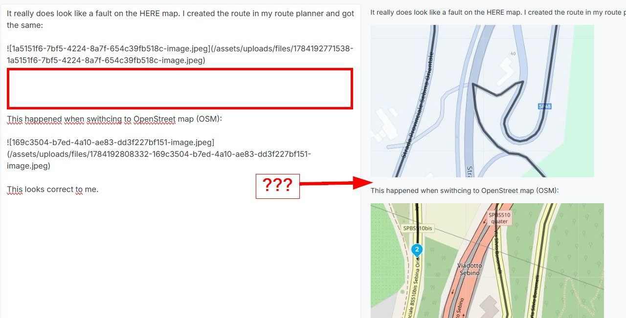
Hi, I also like the idea to switch the map for navigation. Especially Offroad, in the backcountry or even the south of Europe different Maps offer different details and sometimes streets. Also all Maps habe errors and if you can switch you can try to get the correct way.
As an example. A few years ago I traveled with my father in Italy. He with his TomTom and I with Garmin. We had three situations were the systems had very wrong ideas how to get to our destination. Both systems been wrong at some point. The TomTom tried to turn right under a bridge to get on the street above us. Garmin send us in streets that were closed and then ended suddenly.
I think it's not a priority feature, but one very welcome. Maybe including OpenStreetMap for navigation is helpful already?
-
Hi, I also like the idea to switch the map for navigation. Especially Offroad, in the backcountry or even the south of Europe different Maps offer different details and sometimes streets. Also all Maps habe errors and if you can switch you can try to get the correct way.
As an example. A few years ago I traveled with my father in Italy. He with his TomTom and I with Garmin. We had three situations were the systems had very wrong ideas how to get to our destination. Both systems been wrong at some point. The TomTom tried to turn right under a bridge to get on the street above us. Garmin send us in streets that were closed and then ended suddenly.
I think it's not a priority feature, but one very welcome. Maybe including OpenStreetMap for navigation is helpful already?
@nano In MyRoute (website) you can compare the TomTom route with the Garmin (HERE) route by using a special option in the toolkit. This way you can adjust the route in such a way that TomTom and Garmin (HERE) use the same route.
-
Hi, I also like the idea to switch the map for navigation. Especially Offroad, in the backcountry or even the south of Europe different Maps offer different details and sometimes streets. Also all Maps habe errors and if you can switch you can try to get the correct way.
As an example. A few years ago I traveled with my father in Italy. He with his TomTom and I with Garmin. We had three situations were the systems had very wrong ideas how to get to our destination. Both systems been wrong at some point. The TomTom tried to turn right under a bridge to get on the street above us. Garmin send us in streets that were closed and then ended suddenly.
I think it's not a priority feature, but one very welcome. Maybe including OpenStreetMap for navigation is helpful already?
As far as I am aware, MRA cannot currently Navigate Off-Road Tracks.
You can however source Off-Road GPX Files externally and import them into MRA as Route-Tracks.
You will not get any navigation prompts its just a “follow the line” set up.
The example below is UK Green Lane that It is only available to Walkers, Horses, Motorcycles and Bicycles not Cars or Horse Drawn Carriages.You may already be aware of it but the TET (Trans European Trails) has a fantastic source of Off-Road GPX Files.

-
Thank you for your answers.
@Dikke-Wim, I know, and I do that on a regular basis. At least for longer trips and when I am not certain what is the best possible road.
What I mean is that the same feature might be valuable for navigation as well, because possible different routing. It's not a must have, but we are talking here about ways to improve and add features and I believe it can be a valuable one.@Lynchy67, the follow the line setup is offroad more than enough, I think. In my opinion also in this case having the option to switch the map view or map data can be valuable. Usually, offroad tracks are not that well documented in maps. So, in case you are in a dead end you might want to search the map for a different way. Being able to switch maps for that can potentially be much help.
As I said this is only my thoughts on the topic how I believe the app can be improved with additional cool features. Nothing mandatory and in this case more like a feature that is used in edge cases. During normal weekend travelling I just read a road sign in case the navigation has some issues. In the end its not like we can’t also think ourselfes.

Hello! It looks like you're interested in this conversation, but you don't have an account yet.
Getting fed up of having to scroll through the same posts each visit? When you register for an account, you'll always come back to exactly where you were before, and choose to be notified of new replies (either via email, or push notification). You'll also be able to save bookmarks and upvote posts to show your appreciation to other community members.
With your input, this post could be even better 💗
Register Login-
0888
-
09213
-
0431.2k
-
010311
-
0359
-
07244
-
0297.8k
-
0244