11 day motorcycle trip Next test
-
Hello everyone, just back from an 11 day motorcycle trip around Ireland where I have been thoroughly testing the MRA Navigation Next app. You can see the routes in the following link: https://www.myrouteapp.com/es/social/folder/7482054?mode=share
My computer is a Samsung Tab Active 3 with Android version 13 (One UI 5.1)
I went on a trip with the Next version 3.2.10 and the update to 3.2.11-163 arrived while I was already in Ireland while traveling. I have to say that in this update the stability has improved a lot, at least for me.
During these days, I have been collecting bugs and possible improvements that I think could be interesting:
• Bugs:
- Accuracy, as other colleagues have already reported, should improve a lot, it generates mistakes when you have to perform a maneuver to follow a route, for example at junctions, lane changes, etc. Especially when you drive through a city or roads with intersections. The lag is obvious.
- Another of the main failures that I have found is that the route closes when you make a stop to refuel, drink coffee or eat and the app returns to the main menu. I think a colleague has also reported it. This is quite annoying as you have to reload the current route and jump to the next waypoint. Imagine when you are wearing gloves and you have already started the march. It should always keep navigating the route even if there is a device reboot, or at least ask if you want to continue or exit when you open the app.
- Sometimes when you switch apps or press orientation change (compass button), the cursor stays on the bottom edge of the screen and there is no way to get it to the center of the screen. It's annoying because the cursor is barely visible and there's no way to position it in the center unless you exit the app and reopen it.
- When you zoom, the cursor does not continue navigating with that zoom and stays in the position of the map where it is and does not continue the path, you must press change orientation and then the automatic zoom is set. When you are doing a route with curves and you want to see them closer and know the route in advance, it is useful that you can zoom and the cursor continues to navigate. I have made with Tasker a function that taps with one finger to zoom in and taps with two fingers to zoom out. In this example case the cursor should stay in the center and follow the navigation with the selected zoom.
- Battery consumption, on some occasions, Next consumes too much battery and it is only possible to solve it by restarting the device
• Improvements
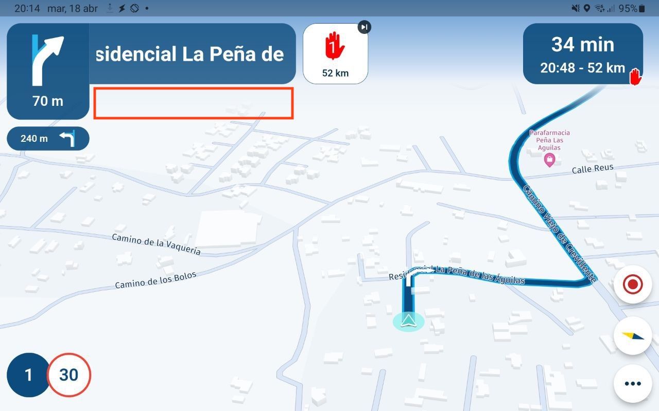
- The name of the next waypoint (not a shaping point) should appear, not just when you are approaching the waypoint, somewhere on the screen. If there is an instruction before that waypoint, the name is not displayed until you are very close. It would be nice to always see the name of the next waypoint. An example of where the waypoint name could be located would be where the red rectangle appears:
- Add altitude information on the screen
- Add information about the city where you are
- In the waypoints menu, insert a cursor or indicator to know between which two waypoints you are at that moment
- Having the possibility of browsing offline but having traffic information online, in this way data consumption would be less
- Have a rain radar to know the possibility of rain en route
P.S.: I have seen that you have released version 3.2.12, which I have not been able to test. If there are bugs fixed in this latest version, please excuse me.
Finally, let me tell you that I have been using BaseCamp and BMW Navigator V for several years and during this trip I have confirmed that MRA Navigation Next is going to be my definitive navigator and I will use Planner from now on to program my routes. Congratulations for the incredible work you are doing and for listening to our needs and putting them into practice.
-
Hello everyone, just back from an 11 day motorcycle trip around Ireland where I have been thoroughly testing the MRA Navigation Next app. You can see the routes in the following link: https://www.myrouteapp.com/es/social/folder/7482054?mode=share
My computer is a Samsung Tab Active 3 with Android version 13 (One UI 5.1)
I went on a trip with the Next version 3.2.10 and the update to 3.2.11-163 arrived while I was already in Ireland while traveling. I have to say that in this update the stability has improved a lot, at least for me.
During these days, I have been collecting bugs and possible improvements that I think could be interesting:
• Bugs:
- Accuracy, as other colleagues have already reported, should improve a lot, it generates mistakes when you have to perform a maneuver to follow a route, for example at junctions, lane changes, etc. Especially when you drive through a city or roads with intersections. The lag is obvious.
- Another of the main failures that I have found is that the route closes when you make a stop to refuel, drink coffee or eat and the app returns to the main menu. I think a colleague has also reported it. This is quite annoying as you have to reload the current route and jump to the next waypoint. Imagine when you are wearing gloves and you have already started the march. It should always keep navigating the route even if there is a device reboot, or at least ask if you want to continue or exit when you open the app.
- Sometimes when you switch apps or press orientation change (compass button), the cursor stays on the bottom edge of the screen and there is no way to get it to the center of the screen. It's annoying because the cursor is barely visible and there's no way to position it in the center unless you exit the app and reopen it.
- When you zoom, the cursor does not continue navigating with that zoom and stays in the position of the map where it is and does not continue the path, you must press change orientation and then the automatic zoom is set. When you are doing a route with curves and you want to see them closer and know the route in advance, it is useful that you can zoom and the cursor continues to navigate. I have made with Tasker a function that taps with one finger to zoom in and taps with two fingers to zoom out. In this example case the cursor should stay in the center and follow the navigation with the selected zoom.
- Battery consumption, on some occasions, Next consumes too much battery and it is only possible to solve it by restarting the device
• Improvements
- The name of the next waypoint (not a shaping point) should appear, not just when you are approaching the waypoint, somewhere on the screen. If there is an instruction before that waypoint, the name is not displayed until you are very close. It would be nice to always see the name of the next waypoint. An example of where the waypoint name could be located would be where the red rectangle appears:
- Add altitude information on the screen
- Add information about the city where you are
- In the waypoints menu, insert a cursor or indicator to know between which two waypoints you are at that moment
- Having the possibility of browsing offline but having traffic information online, in this way data consumption would be less
- Have a rain radar to know the possibility of rain en route
P.S.: I have seen that you have released version 3.2.12, which I have not been able to test. If there are bugs fixed in this latest version, please excuse me.
Finally, let me tell you that I have been using BaseCamp and BMW Navigator V for several years and during this trip I have confirmed that MRA Navigation Next is going to be my definitive navigator and I will use Planner from now on to program my routes. Congratulations for the incredible work you are doing and for listening to our needs and putting them into practice.
@bluetuz Good evening, I was wondering did you run the test offline maps or just with an internet connection. I'm going to Scotland soon and I'm in doubt driving with offline maps or the internet, what I read in the messages is not quite stable offline yet, and the internet I don't know how stable that is up in Scotland yet
-
@bluetuz Good evening, I was wondering did you run the test offline maps or just with an internet connection. I'm going to Scotland soon and I'm in doubt driving with offline maps or the internet, what I read in the messages is not quite stable offline yet, and the internet I don't know how stable that is up in Scotland yet
@G-Grote-Ganseij I did the NC500 last year with the old MRA navigation using data and didn't have any issues
-
@bluetuz Good evening, I was wondering did you run the test offline maps or just with an internet connection. I'm going to Scotland soon and I'm in doubt driving with offline maps or the internet, what I read in the messages is not quite stable offline yet, and the internet I don't know how stable that is up in Scotland yet
@G-Grote-Ganseij I'm also going to Scotland in June and I'm curious too. Data roaming is expensive in Scotland.
BMW R1300 GS, BMW Connect Ride Next navigator; Quad Lock with Samsung Galaxy Ultra, iPad Pro (iPadOS 18.0 bèta version) MacBook Pro (MacOS Sequoia 15.2 bèta version), iMac (MacOS Monterey 12.7.6)
-
@G-Grote-Ganseij I'm also going to Scotland in June and I'm curious too. Data roaming is expensive in Scotland.
@Dikke-Wim i did not find it used much, my provider (Sky Mobile) i get 8gig per month and it didn't use it so I had no extra charges, but I am talking the old MRA nav the Beta has much more info so may use more but plenty of coverage
-
@bluetuz Good evening, I was wondering did you run the test offline maps or just with an internet connection. I'm going to Scotland soon and I'm in doubt driving with offline maps or the internet, what I read in the messages is not quite stable offline yet, and the internet I don't know how stable that is up in Scotland yet
@G-Grote-Ganseij Hello, I downloaded the maps before leaving but I was always navigating online because Ireland is part of the EU and my operator allows me to use my data rate in the EU zone. I'm sorry I can't help you
-
Hello everyone, just back from an 11 day motorcycle trip around Ireland where I have been thoroughly testing the MRA Navigation Next app. You can see the routes in the following link: https://www.myrouteapp.com/es/social/folder/7482054?mode=share
My computer is a Samsung Tab Active 3 with Android version 13 (One UI 5.1)
I went on a trip with the Next version 3.2.10 and the update to 3.2.11-163 arrived while I was already in Ireland while traveling. I have to say that in this update the stability has improved a lot, at least for me.
During these days, I have been collecting bugs and possible improvements that I think could be interesting:
• Bugs:
- Accuracy, as other colleagues have already reported, should improve a lot, it generates mistakes when you have to perform a maneuver to follow a route, for example at junctions, lane changes, etc. Especially when you drive through a city or roads with intersections. The lag is obvious.
- Another of the main failures that I have found is that the route closes when you make a stop to refuel, drink coffee or eat and the app returns to the main menu. I think a colleague has also reported it. This is quite annoying as you have to reload the current route and jump to the next waypoint. Imagine when you are wearing gloves and you have already started the march. It should always keep navigating the route even if there is a device reboot, or at least ask if you want to continue or exit when you open the app.
- Sometimes when you switch apps or press orientation change (compass button), the cursor stays on the bottom edge of the screen and there is no way to get it to the center of the screen. It's annoying because the cursor is barely visible and there's no way to position it in the center unless you exit the app and reopen it.
- When you zoom, the cursor does not continue navigating with that zoom and stays in the position of the map where it is and does not continue the path, you must press change orientation and then the automatic zoom is set. When you are doing a route with curves and you want to see them closer and know the route in advance, it is useful that you can zoom and the cursor continues to navigate. I have made with Tasker a function that taps with one finger to zoom in and taps with two fingers to zoom out. In this example case the cursor should stay in the center and follow the navigation with the selected zoom.
- Battery consumption, on some occasions, Next consumes too much battery and it is only possible to solve it by restarting the device
• Improvements
- The name of the next waypoint (not a shaping point) should appear, not just when you are approaching the waypoint, somewhere on the screen. If there is an instruction before that waypoint, the name is not displayed until you are very close. It would be nice to always see the name of the next waypoint. An example of where the waypoint name could be located would be where the red rectangle appears:
- Add altitude information on the screen
- Add information about the city where you are
- In the waypoints menu, insert a cursor or indicator to know between which two waypoints you are at that moment
- Having the possibility of browsing offline but having traffic information online, in this way data consumption would be less
- Have a rain radar to know the possibility of rain en route
P.S.: I have seen that you have released version 3.2.12, which I have not been able to test. If there are bugs fixed in this latest version, please excuse me.
Finally, let me tell you that I have been using BaseCamp and BMW Navigator V for several years and during this trip I have confirmed that MRA Navigation Next is going to be my definitive navigator and I will use Planner from now on to program my routes. Congratulations for the incredible work you are doing and for listening to our needs and putting them into practice.
@bluetuz thanks for the great feedback and kind words! Hope you had a great trip.
Issues:
1: known as you mentioned
2: working on that now")
3: should be fixed in the latest update
4: that is correct, zoom buttons will be added later. You can achieve this already using a bluetooth keyboard.
5: we are investigating thisImprovements:
1: working on it!
2: might do that, not really sure yet how
3: like what?
4: that is pretty smart Like it a lot!
5: that won’t be possible. Also, if maps are downloaded offline they are always used from storage. Only routing will be done online (if not in offline mode) and that internet usage is minimal
6: great idea, not for nowThanks for all your feedback!
-
@bluetuz thanks for the great feedback and kind words! Hope you had a great trip.
Issues:
1: known as you mentioned
2: working on that now
3: should be fixed in the latest update
4: that is correct, zoom buttons will be added later. You can achieve this already using a bluetooth keyboard.
5: we are investigating thisImprovements:
1: working on it!
2: might do that, not really sure yet how
3: like what?
4: that is pretty smart Like it a lot!
5: that won’t be possible. Also, if maps are downloaded offline they are always used from storage. Only routing will be done online (if not in offline mode) and that internet usage is minimal
6: great idea, not for nowThanks for all your feedback!
@Corjan-Meijerink I like the number 3 in improvements. Very often I catch myself going through a town or city, and I do not really know where I am. The name of the town/city would be enough me. We do not want to overload the display.
-
Hello everyone, just back from an 11 day motorcycle trip around Ireland where I have been thoroughly testing the MRA Navigation Next app. You can see the routes in the following link: https://www.myrouteapp.com/es/social/folder/7482054?mode=share
My computer is a Samsung Tab Active 3 with Android version 13 (One UI 5.1)
I went on a trip with the Next version 3.2.10 and the update to 3.2.11-163 arrived while I was already in Ireland while traveling. I have to say that in this update the stability has improved a lot, at least for me.
During these days, I have been collecting bugs and possible improvements that I think could be interesting:
• Bugs:
- Accuracy, as other colleagues have already reported, should improve a lot, it generates mistakes when you have to perform a maneuver to follow a route, for example at junctions, lane changes, etc. Especially when you drive through a city or roads with intersections. The lag is obvious.
- Another of the main failures that I have found is that the route closes when you make a stop to refuel, drink coffee or eat and the app returns to the main menu. I think a colleague has also reported it. This is quite annoying as you have to reload the current route and jump to the next waypoint. Imagine when you are wearing gloves and you have already started the march. It should always keep navigating the route even if there is a device reboot, or at least ask if you want to continue or exit when you open the app.
- Sometimes when you switch apps or press orientation change (compass button), the cursor stays on the bottom edge of the screen and there is no way to get it to the center of the screen. It's annoying because the cursor is barely visible and there's no way to position it in the center unless you exit the app and reopen it.
- When you zoom, the cursor does not continue navigating with that zoom and stays in the position of the map where it is and does not continue the path, you must press change orientation and then the automatic zoom is set. When you are doing a route with curves and you want to see them closer and know the route in advance, it is useful that you can zoom and the cursor continues to navigate. I have made with Tasker a function that taps with one finger to zoom in and taps with two fingers to zoom out. In this example case the cursor should stay in the center and follow the navigation with the selected zoom.
- Battery consumption, on some occasions, Next consumes too much battery and it is only possible to solve it by restarting the device
• Improvements
- The name of the next waypoint (not a shaping point) should appear, not just when you are approaching the waypoint, somewhere on the screen. If there is an instruction before that waypoint, the name is not displayed until you are very close. It would be nice to always see the name of the next waypoint. An example of where the waypoint name could be located would be where the red rectangle appears:
- Add altitude information on the screen
- Add information about the city where you are
- In the waypoints menu, insert a cursor or indicator to know between which two waypoints you are at that moment
- Having the possibility of browsing offline but having traffic information online, in this way data consumption would be less
- Have a rain radar to know the possibility of rain en route
P.S.: I have seen that you have released version 3.2.12, which I have not been able to test. If there are bugs fixed in this latest version, please excuse me.
Finally, let me tell you that I have been using BaseCamp and BMW Navigator V for several years and during this trip I have confirmed that MRA Navigation Next is going to be my definitive navigator and I will use Planner from now on to program my routes. Congratulations for the incredible work you are doing and for listening to our needs and putting them into practice.
@bluetuz said in 11 day motorcycle trip Next test:
Hello everyone, just back from an 11 day motorcycle trip around Ireland where I have been thoroughly testing the MRA Navigation Next app. You can see the routes in the following link: https://www.myrouteapp.com/es/social/folder/7482054?mode=share
My computer is a Samsung Tab Active 3 with Android version 13 (One UI 5.1)
I went on a trip with the Next version 3.2.10 and the update to 3.2.11-163 arrived while I was already in Ireland while traveling. I have to say that in this update the stability has improved a lot, at least for me.
During these days, I have been collecting bugs and possible improvements that I think could be interesting:
• Bugs:
- Accuracy, as other colleagues have already reported, should improve a lot, it generates mistakes when you have to perform a maneuver to follow a route, for example at junctions, lane changes, etc. Especially when you drive through a city or roads with intersections. The lag is obvious.
- Another of the main failures that I have found is that the route closes when you make a stop to refuel, drink coffee or eat and the app returns to the main menu. I think a colleague has also reported it. This is quite annoying as you have to reload the current route and jump to the next waypoint. Imagine when you are wearing gloves and you have already started the march. It should always keep navigating the route even if there is a device reboot, or at least ask if you want to continue or exit when you open the app.
- Sometimes when you switch apps or press orientation change (compass button), the cursor stays on the bottom edge of the screen and there is no way to get it to the center of the screen. It's annoying because the cursor is barely visible and there's no way to position it in the center unless you exit the app and reopen it.
- When you zoom, the cursor does not continue navigating with that zoom and stays in the position of the map where it is and does not continue the path, you must press change orientation and then the automatic zoom is set. When you are doing a route with curves and you want to see them closer and know the route in advance, it is useful that you can zoom and the cursor continues to navigate. I have made with Tasker a function that taps with one finger to zoom in and taps with two fingers to zoom out. In this example case the cursor should stay in the center and follow the navigation with the selected zoom.
- Battery consumption, on some occasions, Next consumes too much battery and it is only possible to solve it by restarting the device
• Improvements
- The name of the next waypoint (not a shaping point) should appear, not just when you are approaching the waypoint, somewhere on the screen. If there is an instruction before that waypoint, the name is not displayed until you are very close. It would be nice to always see the name of the next waypoint. An example of where the waypoint name could be located would be where the red rectangle appears:
- Add altitude information on the screen
- Add information about the city where you are
- In the waypoints menu, insert a cursor or indicator to know between which two waypoints you are at that moment
- Having the possibility of browsing offline but having traffic information online, in this way data consumption would be less
- Have a rain radar to know the possibility of rain en route
P.S.: I have seen that you have released version 3.2.12, which I have not been able to test. If there are bugs fixed in this latest version, please excuse me.
Finally, let me tell you that I have been using BaseCamp and BMW Navigator V for several years and during this trip I have confirmed that MRA Navigation Next is going to be my definitive navigator and I will use Planner from now on to program my routes. Congratulations for the incredible work you are doing and for listening to our needs and putting them into practice.
Dear bluetuz,
Thank you for testing so completely, I can only underwrite your findings. Also coming from Base Camp and BMW navigator, this will be my main Routing tool.
I am sure , the team of MRA will present an incredible tool soon.
-
@Corjan-Meijerink I like the number 3 in improvements. Very often I catch myself going through a town or city, and I do not really know where I am. The name of the town/city would be enough me. We do not want to overload the display.
@UltraStar Exactly, that's what I was referring to. Simply a field where the city where you are appears
-
@bluetuz said in 11 day motorcycle trip Next test:
Hello everyone, just back from an 11 day motorcycle trip around Ireland where I have been thoroughly testing the MRA Navigation Next app. You can see the routes in the following link: https://www.myrouteapp.com/es/social/folder/7482054?mode=share
My computer is a Samsung Tab Active 3 with Android version 13 (One UI 5.1)
I went on a trip with the Next version 3.2.10 and the update to 3.2.11-163 arrived while I was already in Ireland while traveling. I have to say that in this update the stability has improved a lot, at least for me.
During these days, I have been collecting bugs and possible improvements that I think could be interesting:
• Bugs:
- Accuracy, as other colleagues have already reported, should improve a lot, it generates mistakes when you have to perform a maneuver to follow a route, for example at junctions, lane changes, etc. Especially when you drive through a city or roads with intersections. The lag is obvious.
- Another of the main failures that I have found is that the route closes when you make a stop to refuel, drink coffee or eat and the app returns to the main menu. I think a colleague has also reported it. This is quite annoying as you have to reload the current route and jump to the next waypoint. Imagine when you are wearing gloves and you have already started the march. It should always keep navigating the route even if there is a device reboot, or at least ask if you want to continue or exit when you open the app.
- Sometimes when you switch apps or press orientation change (compass button), the cursor stays on the bottom edge of the screen and there is no way to get it to the center of the screen. It's annoying because the cursor is barely visible and there's no way to position it in the center unless you exit the app and reopen it.
- When you zoom, the cursor does not continue navigating with that zoom and stays in the position of the map where it is and does not continue the path, you must press change orientation and then the automatic zoom is set. When you are doing a route with curves and you want to see them closer and know the route in advance, it is useful that you can zoom and the cursor continues to navigate. I have made with Tasker a function that taps with one finger to zoom in and taps with two fingers to zoom out. In this example case the cursor should stay in the center and follow the navigation with the selected zoom.
- Battery consumption, on some occasions, Next consumes too much battery and it is only possible to solve it by restarting the device
• Improvements
- The name of the next waypoint (not a shaping point) should appear, not just when you are approaching the waypoint, somewhere on the screen. If there is an instruction before that waypoint, the name is not displayed until you are very close. It would be nice to always see the name of the next waypoint. An example of where the waypoint name could be located would be where the red rectangle appears:
- Add altitude information on the screen
- Add information about the city where you are
- In the waypoints menu, insert a cursor or indicator to know between which two waypoints you are at that moment
- Having the possibility of browsing offline but having traffic information online, in this way data consumption would be less
- Have a rain radar to know the possibility of rain en route
P.S.: I have seen that you have released version 3.2.12, which I have not been able to test. If there are bugs fixed in this latest version, please excuse me.
Finally, let me tell you that I have been using BaseCamp and BMW Navigator V for several years and during this trip I have confirmed that MRA Navigation Next is going to be my definitive navigator and I will use Planner from now on to program my routes. Congratulations for the incredible work you are doing and for listening to our needs and putting them into practice.
Dear bluetuz,
Thank you for testing so completely, I can only underwrite your findings. Also coming from Base Camp and BMW navigator, this will be my main Routing tool.
I am sure , the team of MRA will present an incredible tool soon.@HOG-77 Yes, seeing the progress of the tool, I am also sure that it will be very powerful
-
@G-Grote-Ganseij Hello, I downloaded the maps before leaving but I was always navigating online because Ireland is part of the EU and my operator allows me to use my data rate in the EU zone. I'm sorry I can't help you
@bluetuz when I go on a trip I download the offline maps anyway, I'm just thinking whether I'm going to drive with the old myroute navigation or with the new myroute Next with the offline maps. but thanks anyway for the information
Hello! It looks like you're interested in this conversation, but you don't have an account yet.
Getting fed up of having to scroll through the same posts each visit? When you register for an account, you'll always come back to exactly where you were before, and choose to be notified of new replies (either via email, or push notification). You'll also be able to save bookmarks and upvote posts to show your appreciation to other community members.
With your input, this post could be even better 💗
Register Login-
013166
-
2974
-
111240
-
0431.2k
-
0459
-
0362
-
018369
-
0262