
How to?: Modify a "Route-Track"
-
Hi,
Does anybody know if it is possible to modify a downloaded Track with MRA gold?
Context:
I'm trying to use parts of a TET track that i've uploaded in MRA. I can ofcourse choose "Edit route track" but, this automatically places waypoints on the route line and makes a "Route" out of it, which completely destroys the offroad section.I already tried to somehowe import the downloaded Track in the route editor (Routing Options: Offroad) but, that is not an option.
Any tips are welcome.
Regards, Korneel -
Hi,
Does anybody know if it is possible to modify a downloaded Track with MRA gold?
Context:
I'm trying to use parts of a TET track that i've uploaded in MRA. I can ofcourse choose "Edit route track" but, this automatically places waypoints on the route line and makes a "Route" out of it, which completely destroys the offroad section.I already tried to somehowe import the downloaded Track in the route editor (Routing Options: Offroad) but, that is not an option.
Any tips are welcome.
Regards, Korneel
@kme
Hello Korneel,
The fact that the TET-Track is adjusted is because the route is calculated via the routing settings of the chosen map.
What you can do is:
Open the Track
Click on use route
A route is created from the track with waypoints.
Click on the 2nd route point and then click on the 3 dots to open the route point menu.
Then choose the skip option.
If you make the track visible via the left menu, you can set the waypoints so that it follows the track, but set every waypoint to skip.BMW BMW Connected Ride Navigator/Garmin Zumo XT3/XT2/XT//Tourstart/ MyRouteapp (The App)/...
Een dag niet gelachen is een dag niet geleefd / Een route is net zo goed als deze uitgezet is. -
@kme
Hello Korneel,
The fact that the TET-Track is adjusted is because the route is calculated via the routing settings of the chosen map.
What you can do is:
Open the Track
Click on use route
A route is created from the track with waypoints.
Click on the 2nd route point and then click on the 3 dots to open the route point menu.
Then choose the skip option.
If you make the track visible via the left menu, you can set the waypoints so that it follows the track, but set every waypoint to skip.
@hans-van-de-ven-mra-master
Hi Hans,
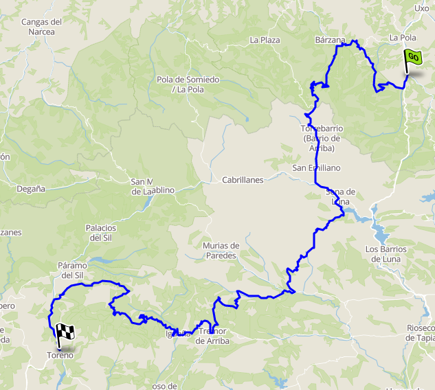
Thanks for your reply, however the method doesn't work (or I'm doing something wrong).This is one of the original Tracks (TET Spain Section 005) that I want to modify (and later combine with ohter Tracks section) in MRA:
When choosing <+ Edit route track> and <Routing options --> Offroad> MRA makes this:
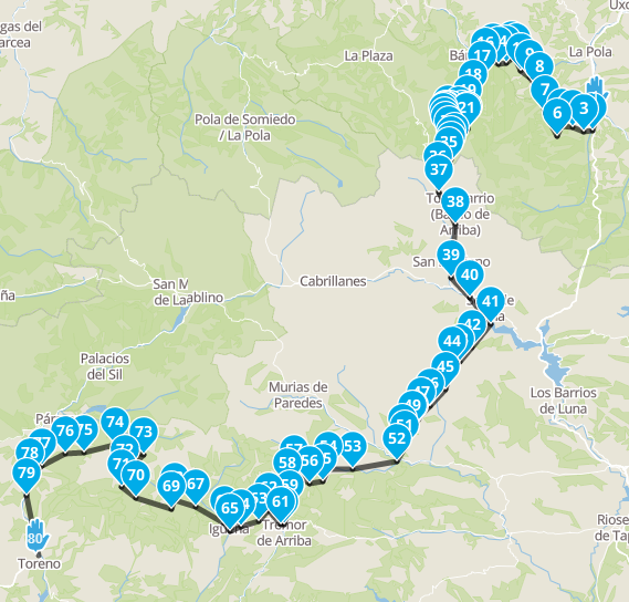
Now lets say I save this Route as a Track again and upload that to my Garmin (which I just use to plot a line of the Track on the map, so no route calculations / guidance or anything)... than the plotted Track is way too coarse. Meaning you'll end up searching / gambling on every junction and potentially missing the scenic route.
Below an example:
Actual Track before editing in MRA:
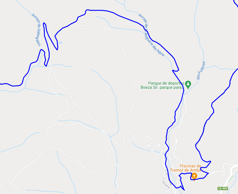
Track after editing in MRA:
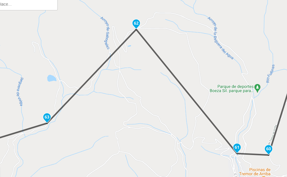
Any idea how this could be solved?
-
@hans-van-de-ven-mra-master
Hi Hans,
Thanks for your reply, however the method doesn't work (or I'm doing something wrong).This is one of the original Tracks (TET Spain Section 005) that I want to modify (and later combine with ohter Tracks section) in MRA:
When choosing <+ Edit route track> and <Routing options --> Offroad> MRA makes this:
Now lets say I save this Route as a Track again and upload that to my Garmin (which I just use to plot a line of the Track on the map, so no route calculations / guidance or anything)... than the plotted Track is way too coarse. Meaning you'll end up searching / gambling on every junction and potentially missing the scenic route.
Below an example:
Actual Track before editing in MRA:
Track after editing in MRA:
Any idea how this could be solved?
Hi KME,
I am an out and out fan boy of MRA as far as plotting Road Routes is concerned and there is nothing out there that comes anywhere close to its capabilities for normal road routes.
However as you have probably worked out for yourself some of the TET Routes run for hundreds of miles Off Road and On Road, to plot those in MRA Route Planner using the “Skip” option is just not a viable option in my opinion!My advice would be to take a look at OSMAND (OpenStreetMap Automatic Navigation Directions)
Whilst you will see that there is a free version available, you will soon realise that the way the maps are provided it is inevitable that you will have to pay eventually.
You can pay a one off fee of £7.99 UK Sterling for all the maps for Europe or a £12.99 UK Sterling one off fee for the whole world.There is a bit of a learning curve involved in getting to grips with OSMAND but it is worth it in my view.
Here is Segment 5 of Spain in Purple with full voice navigation (I never use this personally and it can be turned off).
I had to make this a low res image as the max file size is 2mb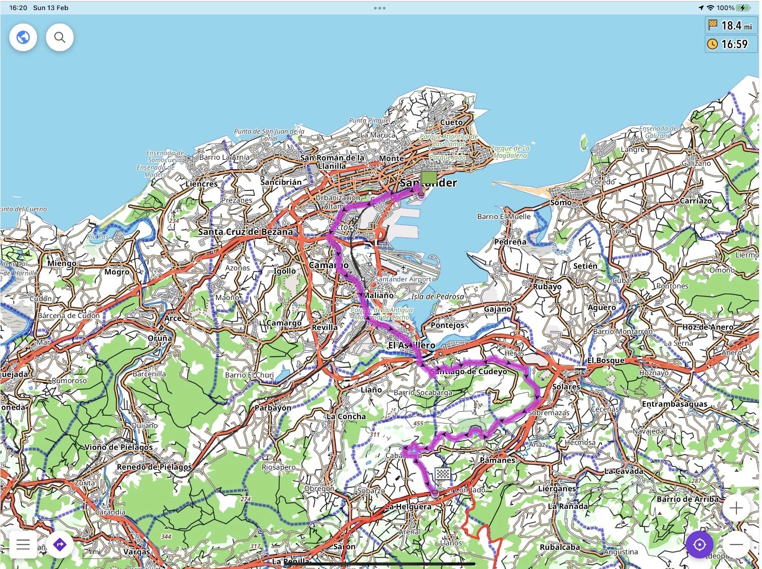
You don’t stop riding when you get old, you get old when you stop riding.
-
Hi KME,
I am an out and out fan boy of MRA as far as plotting Road Routes is concerned and there is nothing out there that comes anywhere close to its capabilities for normal road routes.
However as you have probably worked out for yourself some of the TET Routes run for hundreds of miles Off Road and On Road, to plot those in MRA Route Planner using the “Skip” option is just not a viable option in my opinion!My advice would be to take a look at OSMAND (OpenStreetMap Automatic Navigation Directions)
Whilst you will see that there is a free version available, you will soon realise that the way the maps are provided it is inevitable that you will have to pay eventually.
You can pay a one off fee of £7.99 UK Sterling for all the maps for Europe or a £12.99 UK Sterling one off fee for the whole world.There is a bit of a learning curve involved in getting to grips with OSMAND but it is worth it in my view.
Here is Segment 5 of Spain in Purple with full voice navigation (I never use this personally and it can be turned off).
I had to make this a low res image as the max file size is 2mb
@steve-lynch said in How to?: Modify a "Route-Track":
I am an out and out fan boy of MRA as far as plotting Road Routes is concerned and there is nothing out there that comes anywhere close to its capabilities for normal road routes.
However as you have probably worked out for yourself some of the TET Routes run for hundreds of miles Off Road and On Road, to plot those in MRA Route Planner using the “Skip” option is just not a viable option in my opinion!Yes, Off-road navigation requires an entirely different toolset.
-
@hans-van-de-ven-mra-master
Hi Hans,
Thanks for your reply, however the method doesn't work (or I'm doing something wrong).This is one of the original Tracks (TET Spain Section 005) that I want to modify (and later combine with ohter Tracks section) in MRA:
When choosing <+ Edit route track> and <Routing options --> Offroad> MRA makes this:
Now lets say I save this Route as a Track again and upload that to my Garmin (which I just use to plot a line of the Track on the map, so no route calculations / guidance or anything)... than the plotted Track is way too coarse. Meaning you'll end up searching / gambling on every junction and potentially missing the scenic route.
Below an example:
Actual Track before editing in MRA:
Track after editing in MRA:
Any idea how this could be solved?

Hello! It looks like you're interested in this conversation, but you don't have an account yet.
Getting fed up of having to scroll through the same posts each visit? When you register for an account, you'll always come back to exactly where you were before, and choose to be notified of new replies (either via email, or push notification). You'll also be able to save bookmarks and upvote posts to show your appreciation to other community members.
With your input, this post could be even better 💗
Register Login-
 0964
0964
-
 1826
1826
-
 08321
08321
-
 0558
0558
-
 012440
-
0387
-
0524
-
 013641